Alberta Rocky Mountain Sculpin Recovery Plan 2012-2022 - Alberta Species at Risk Recovery Plan No. 27
←
→
Page content transcription
If your browser does not render page correctly, please read the page content below
Alberta Rocky Mountain Sculpin Recovery Plan
                 2012-2022

        Alberta Species at Risk Recovery Plan No. 27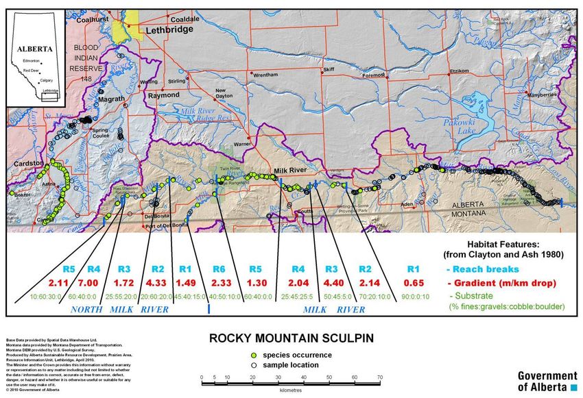
Alberta Rocky Mountain Sculpin
                    Recovery Plan 2012-2022

                                       Prepared by:

                  The Alberta Rocky Mountain Sculpin Recovery Team

                       Roy Audett, Milk River Ranchers’ Association
Michael Bryski, Aquatic Biologist, Water Management Operations, Alberta Environment and
                             Sustainable Resource Development
  Terry Clayton (Co-chair), Fish Biologist, Alberta Environment and Sustainable Resource
                                        Development
  Warren Cunningham, Councilor for the County of Warner and member of the Milk River
                                Watershed Council of Canada
                    Lori Goater, Southern Alberta Environmental Group
                   Ken Miller, Milk River Watershed Council of Canada
Shane Petry (Co-chair), Senior Species at Risk Biologist, Department of Fisheries and Oceans,
                                 Central and Arctic Region
 Richard Quinlan, Provincial Species at Risk Specialist, Alberta Environment and Sustainable
                                   Resource Development
         Bruce Stewart (Secretariat), Arctic Biological Consultants, Winnipeg, MB

                                      March 2013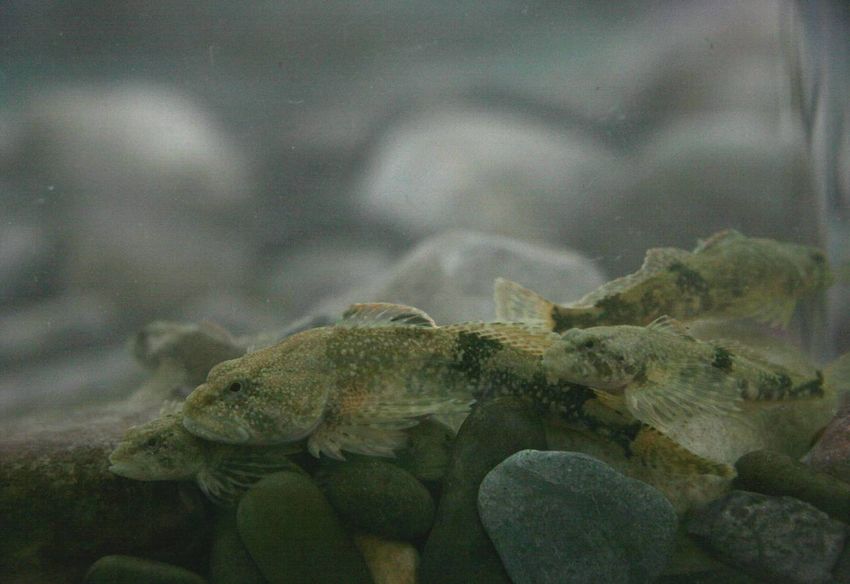
Publication No.: I/603
ISBN No. 978-1-4601-0229-9 (On-line Edition)
ISSN: 1702-4900 (On-line Edition)

Cover photos: Terry Clayton, Alberta Environment and Sustainable Resource Development,
Lethbridge, and Karen Scott, Fisheries and Oceans Canada, Winnipeg.

For copies of this report, contact:

Information Centre – Publications
Alberta Environment and Sustainable Resource Development
Main Floor, Great West Life Building
9920 – 108 Street
Edmonton, Alberta, Canada T5K 2M4
Telephone: (780) 422-2079

OR

Visit the Species at Risk Program web site at:

http://srd.alberta.ca/FishWildlife/SpeciesAtRisk/Default.aspx

This publication may be cited as:

The Alberta Rocky Mountain Sculpin Recovery Team. 2013. Alberta Rocky Mountain Sculpin
Recovery Plan: 2012-2022. Alberta Environment and Sustainable Resource Development,
Alberta Species at Risk Recovery Plan No. 27. Edmonton, AB. 61 pp.

                                                 ii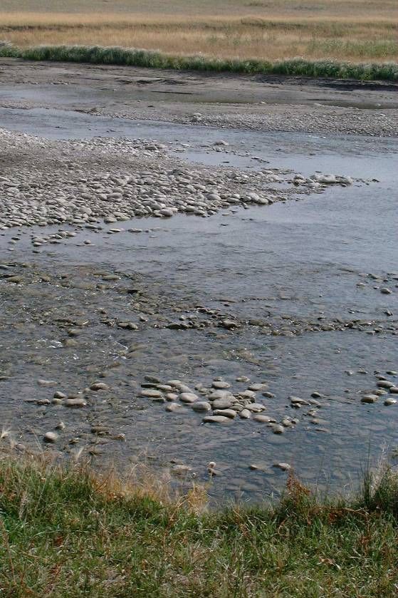
PREFACE

Albertans are fortunate to share their province with a diverse variety of wild species.
Populations of most species of plants and animals are healthy and secure. However, a small
number of species are either naturally rare or are now imperiled because of human activities.
Alberta recovery plans establish a basis for cooperation among government, industry,
conservation groups, landowners and other stakeholders to ensure these species and populations
are restored or maintained for future generations.

Alberta’s commitment to the Accord for the Protection of Species at Risk and to the National
Framework for the Conservation of Species at Risk, combined with requirements established
under Alberta’s Wildlife Act and the federal Species at Risk Act, has resulted in the development
of a provincial recovery program. An overall goal of the recovery program is to restore species
identified as Threatened or Endangered to viable, naturally self-sustaining populations within
Alberta or to maintain species at naturally low levels. The policy document: Alberta’s Strategy
for the Management of Species at Risk (2009-2014) provides broader program context for
recovery activities.

Alberta species at risk recovery plans are prepared under the Species at Risk Program within
Alberta Environment and Sustainable Resource Development. This may include involvement of
a recovery team composed of a variety of stakeholders including conservation organizations,
industry, landowners, resource users, universities, government agencies and others. Membership
is by invitation from the Director of Wildlife Management, and may include representation from
a diversity of interests unique to each species and circumstance. Conservation and management
of these species continues during preparation of the recovery plan.

Alberta recovery plans are provided as advice to the Minister responsible for fish and wildlife
management and to all Albertans. Alberta’s Endangered Species Conservation Committee
reviews draft recovery plans, and provides recommendations to the Minister. In some cases,
additional opportunities for review by the public may also be provided. Plans accepted and
approved for implementation by the Minister are published as government recovery plans.
Approved plans are a summary of the Department’s commitment to work with involved
stakeholders to coordinate and implement conservation actions necessary to restore or maintain
these species.

Recovery plans include three main sections: background information that highlights species
biology, population trends, and threats; a recovery strategy section that outlines goals, objectives,
and strategies to address the threats; and an action plan that profiles priority actions required to
maintain or restore the Threatened or Endangered species. Each approved recovery plan
undergoes an annual progress review. Implementation of each recovery plan is subject to the
availability of resources, from within and from outside government.

                                                 iii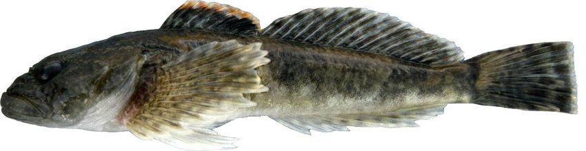
TABLE OF CONTENTS

ACKNOWLEDGEMENTS ....................................................................................................... VI
EXECUTIVE SUMMARY ...................................................................................................... VII
1.0 INTRODUCTION.................................................................................................................. 1
    1.1 Provincial and Federal Status ........................................................................................................................1
    1.2 Recovery Team ................................................................................................................................................1
2.0 SPECIES BIOLOGY............................................................................................................. 2
    2.1 Species Description..........................................................................................................................................2
    2.2 Environmental Setting ....................................................................................................................................3
    2.3 Population and Distribution Context.............................................................................................................6
    2.4 Biology and Life History..............................................................................................................................10
3.0 THREATS AND LIMITING FACTORS........................................................................... 18
    3.1 Limiting Factors ............................................................................................................................................18
    3.2 Threat Classification .....................................................................................................................................19
    3.3 Description of Threats...................................................................................................................................19
4.0 CRITICAL HABITAT ......................................................................................................... 32
5.0 KNOWLEDGE GAPS AND RESEARCH PRIORITIES ................................................ 33
6.0 RECENT RECOVERY AND CONSERVATION EFFORTS ......................................... 34
7.0 RECOVERY STRATEGY................................................................................................... 35
    7.1 Biological and Technical Feasibility of Recovery .......................................................................................35
    7.2 Guiding Principles.........................................................................................................................................36
    7.3 Recovery Goal................................................................................................................................................37
    7.4 Recovery Objectives......................................................................................................................................38
    7.5 Strategies for Recovery .................................................................................................................................38
8.0 ACTION PLAN..................................................................................................................... 41
    8.1 Introduction ...................................................................................................................................................41
    8.2 Research .........................................................................................................................................................42
    8.3 Monitoring .....................................................................................................................................................44
    8.4 Management and Regulation .......................................................................................................................45
    8.5 Education and Outreach...............................................................................................................................46
9.0 IMPLEMENTATION SCHEDULE ................................................................................... 49
10.0 SOCIO-ECONOMIC CONSIDERATIONS .................................................................... 52
11.0 MULTIPLE SPECIES AT RISK AND RELATED RECOVERY STRATEGIES...... 52
12.0 PLAN EVALUATION AND AMENDMENT.................................................................. 52
13.0 LITERATURE CITED ...................................................................................................... 54
14.0 GLOSSARY ........................................................................................................................ 61

                                                                                   iv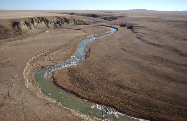
LIST OF FIGURES

Figure 1. Rocky Mountain sculpin (photo credit D. Watkinson, DFO, Winnipeg)........................ 2
Figure 2. Location of the Milk and St. Mary river basins in Alberta. ............................................ 4
Figure 3. Alberta distribution of the Rocky Mountain sculpin showing key habitat
           features.. ......................................................................................................................... 9
Figure 4. Rocky Mountain sculpins on gravel substrate............................................................... 14

                                                         LIST OF TABLES

Table 1. Fish species that occur in Canada in the St. Mary River upstream of the St. Mary
           Dam and/or in the Milk River, with ranges that overlap (Y) or do not overlap
           (N) that of the Rocky Mountain Sculpin. .................................................................... 13
Table 2. Threat to the Rocky Mountain Sculpin from dam construction. .................................... 20
Table 3. Threat to the Rocky Mountain sculpin from dam operation........................................... 20
Table 4. Threat to the Rocky Mountain sculpin from changes in flow. ....................................... 22
Table 5. Threat to the Rocky Mountain sculpin from Didymosphenia geminata......................... 25
Table 6. Threat to the Rocky Mountain sculpin from intentional fish stocking. .......................... 26
Table 7. Threat to the Rocky Mountain sculpin from unintentional species introductions.......... 27
Table 8. Threat to the Rocky Mountain sculpin from point source pollution............................... 29
Table 9. Threat to the Rocky Mountain sculpin from non-point source pollution. ...................... 30
Table 10. Threat to the Rocky Mountain sculpin from scientific sampling. ................................ 31
Table 11. Threat to the Rocky Mountain sculpin from climate change........................................ 31
Table 12. Threat to the Rocky Mountain sculpin from drought. .................................................. 32
Table 13. Recovery objectives, the strategies to address them, and their anticipated effects. ..... 39
Table 14. Implementation Schedule. ............................................................................................ 49

                                                                       v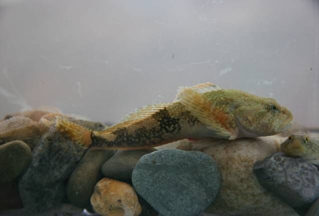
ACKNOWLEDGEMENTS

Alberta Environment and Sustainable Resource Development (AESRD) extends its sincere
appreciation to the many organizations that supported the development of this Alberta recovery
plan and to their representatives who contributed their knowledge and hard work. This report
was prepared by a joint provincial and national recovery team comprised of management
agencies and stakeholders. The team was co-chaired by Terry Clayton (AESRD) and Fred
Hnytka of Fisheries and Oceans Canada (DFO) until his retirement when Shane Petry (DFO)
replaced him as the federal co-chair. Recovery team members are thanked for contributing their
knowledge and for their commitment. Draft writing was done by D.B. Stewart of Arctic
Biological Consultants and by S. Pollard (currently with BC Ministry of the Environment), who
at different times acted as secretariat to the recovery team. Recovery team members included
Roy Audet, Michael Bryski, Warren Cunningham, Lori Goater, Ken Miller, Bruce Stewart,
Emma Hulit, and Richard Quinlan. They made many worthwhile contributions to this strategy
and their efforts are most appreciated. Funding and facilities to support recovery team meetings
was provided by AESRD and DFO. Doug Watkinson of DFO in Winnipeg, MB and Terry
Clayton of AESRD in Lethbridge kindly provided photographs of the Rocky Mountain sculpin.
The recovery team also benefited from the participation of Annabelle Crop Eared Wolf of the
Blood Tribe at the first meeting. Blair Watke of AESRD prepared the fine drainage basin maps.
The recovery team would especially like to thank Don McPhail of the University of British
Columbia, Dave Neely of the California Academy of Sciences, and Doug Watkinson for
providing unpublished results from their work. Doug Watkinson met with the recovery team to
share the results of his ongoing studies of Rocky Mountain sculpin, and provided constructive
reviews of the manuscript. Don Bell and Jeff Burrows of BC Environment generously provided
sculpin samples for future genetic and age comparisons. Drafts of this recovery plan benefited
from constructive reviews by Mark Skiba of DFO Winnipeg and Marie-Claude Geoffrion,
Vanessa Sutton-Pande, and Laurie Wood of DFO Ottawa.

                                               vi
EXECUTIVE SUMMARY

In December 2007, the Rocky Mountain sculpin (Cottus sp.) was listed under Alberta’s Wildlife
Act, which requires the completion of a recovery plan. In August 2006, the populations in the St.
Mary and Milk rivers of Alberta were listed as Threatened under the Species at Risk Act
(SARA). The SARA also requires a recovery plan. Both levels of government specify two years
as the required time frame between listing and provision of a recovery plan for a threatened
species.

The Rocky Mountain Sculpin Recovery team was formed in 2006 to expand on earlier work by
the Milk River Fish Species Recovery Team, which initiated studies of Milk River populations
of the Rocky Mountain sculpin. Ultimately, the recovery team was tasked with developing a
recovery plan that would consider both the St. Mary and Milk river populations, and satisfy both
federal and provincial requirements. The team represented a range of conservation, regulatory
and stakeholder interests, with membership from Fisheries and Oceans Canada; Alberta
Environment and Sustainable Resource Development; the Milk River Watershed Council of
Canada (MRWCC); the Southern Alberta Environmental Group; the Milk River Ranchers’
Association; the Counties of Cardston, Forty Mile and Warner; Villages of Coutts and Warner;
and Town of Milk River.

While there is no evidence that populations of the Rocky Mountain sculpin in Alberta have
declined since the species was first identified here, this small, bottom-dwelling fish is deemed to
be at risk due to its extremely limited range. Within Canada it only occurs in the St. Mary and
Milk rivers of Alberta, and in the Flathead River of British Columbia. Only the Alberta
populations, which COSEWIC (2005) considered a single designatable unit, are considered in
this recovery plan.

The goal and objectives of this ten year recovery plan are directed towards the conservation and
maintenance of the existing Alberta populations. The recovery plan describes the species and its
needs, incorporates a threats assessment, and outlines a broad recovery approach for the Rocky
Mountain sculpin based on the available information. The recovery plan goal is:

     “To protect and maintain self-sustaining populations of the Rocky Mountain
     Sculpin within its current range in the St. Mary and Milk rivers in Canada”.

 Key objectives of the strategy are to:

 1) Quantify and maintain current population levels of Rocky Mountain Sculpin in the St.
    Mary and Milk river watersheds (within the population’s range of natural variation), as
    determined from standardized surveys;
 2) Increase knowledge of the taxonomy, life history, basic biology and habitat requirements of
    the Rocky Mountain sculpin, with a view towards identifying and protecting critical habitat
    and;
 3) Increase our understanding of how human activities affect Rocky Mountain sculpin
    survival, so that potential threats to the species can be avoided, eliminated, or mitigated.

                                                vii
To help achieve this goal and meet the objectives, four general approaches are proposed: 1)
Research, 2) Monitoring, 3) Management and Regulatory Actions, and 4) Education and
Outreach. Within each of these, a number of individual strategies and actions are outlined that
capture the range of tools available to protect and manage the species and to reduce or eliminate
threats to its survival.
The Rocky Mountain Sculpin Recovery Plan 2012-2022 will be subject to periodic reviews
which may involve participation of some or all of the recovery team members. The recovery plan
has a designated life span of ten years, after which it will be reviewed and revised as needed. The
10-year time span of this recovery plan was chosen because of the management objective of
maintaining the current range and population of the Rocky Mountain sculpin, as opposed to a
designated increase in numbers or recovery into former habitats. In this regard, the plan may
differ from other species’ recovery plans for which the management objective is one of recovery,
rather than maintenance.
viii1.0 INTRODUCTION
1.1 Provincial and Federal Status
1.1.1 Alberta Provincial Status
The Alberta general status category of “May Be at Risk” was assigned to this species in 2000.
This led to a detailed status report being prepared in 2004 (Alberta Sustainable Resource
Development 2004). A subsequent review by the Scientific Sub Committee and Endangered
Species Conservation Committee was carried out with a resulting recommendation of
Threatened. The reason for the designation was that the species has a very restricted area of
occupancy, with the only locations in Alberta where this species is found being the Milk River
basin and upper St. Mary River basin of southern Alberta. Dispersal and exchange with adjacent
populations was assessed as being limited. In 2007 a Wildlife Regulation amendment was made
to list the species in Schedule 6, Part 4 as an “Endangered fish”, with a further categorization of
a Threatened species.
1.1.2 Canada National Status
A COSEWIC assessment was completed in May 2005 resulting in a status recommendation of
Threatened. Their reason for designation was that the species has a very restricted area of
occurrence in the St. Mary and Milk rivers in Canada where it has been impacted by habitat loss
and degradation from water diversion, conditions that have been exacerbated in recent years by
drought. In 2006 Schedule 1 of the Species at Risk Act was amended to list the rocky mountain
sculpin as a Threatened species.
Both the federal and provincial status reviews were done during a period when the taxonomic
nomenclature for rocky mountain sculpin was undergoing changes. The species had previously
been referred to as “St. Mary sculpin” and “Eastslope sculpin” but has since been renamed
Rocky Mountain sculpin.
1.2 Recovery Team
The development of this recovery plan was co-led by Alberta Environment and Sustainable
Resource Development and Fisheries and Oceans Canada – Central and Arctic Region and
involved participation of several individuals, organizations and government agencies. The Rocky
Mountain Sculpin Recovery Team was formed in 2006. It continued work begun by the Milk
River Fish Species Recovery Team, which was organized in 2004 to develop a recovery plan for
the Western Silvery Minnow (Hybognathus argyritis) and to initiate recovery efforts for other
potential “species at risk”, including the Rocky Mountain sculpin. The Rocky Mountain Sculpin
Recovery Team was tasked with developing a recovery plan that would consider both the St.
Mary and Milk river populations. The team represented a broad range of conservation, regulatory
and stakeholder interests, with membership from Fisheries and Oceans Canada; Alberta
Environment and Sustainable Resource Development; the Milk River Watershed Council of
Canada (MRWCC); the Southern Alberta Environmental Group; the Milk River Ranchers’
1Association; the Counties of Cardston, Forty Mile and Warner; Villages of Coutts and Warner;
and Town of Milk River. All recovery team meetings were held in Lethbridge, Alberta.
2.0 SPECIES BIOLOGY
2.1 Species Description
The Rocky Mountain sculpin is a bottom-dwelling fish characterized by a large head, heavy
body that tapers towards the tail, and no air bladder. Fish with a total length (TL) from tip of
snout to tip of tail of up to 114 mm have been caught in the Milk River (R.L.&L. Environmental
Services Ltd. 2002).
Figure 1. Rocky Mountain sculpin (photo credit D. Watkinson, DFO, Winnipeg).
The taxonomic identity of the Rocky Mountain Sculpin is uncertain (COSEWIC 2005). Sculpins
in the St. Mary and Milk river populations belong to an undescribed species of the genus Cottus
that is widespread in the upper Missouri River system (Taylor and Gow 2008; D. Neely, pers.
comm. 2008). Recent morphological and molecular genetic analyses by Taylor and Gow (2008)
and Neely (pers. comm.) have demonstrated that a separate population of the same species
occupies portions of the Flathead River system in British Columbia, and that these fish are not
Cottus bairdi punctulatus as suggested by Troffe (1999) and in the Alberta status report (ASRD
2004). These analyses also support the distinction of the Rocky Mountain sculpin from shorthead
sculpin (C. confusus), Columbia mottled sculpin (C. bairdi hubbsi), and other sculpin species in
western North America (COSEWIC 2005; Taylor and Gow 2008; see also Peden et al. 1989).
Efforts are underway to resolve the taxonomy of the western sculpin complex by analyzing
samples from Alberta, British Columbia and Montana (D. Neely, pers. comm.).
The Rocky Mountain sculpin (Cottus sp.) is a small, freshwater fish belonging to the
predominantly marine sculpin family (Cottidae). It has also been referred to as the St. Mary
shorthead sculpin (ASRD 2004), and the Eastslope sculpin (COSEWIC 2005; Taylor and Gow
2008). These fish are locally abundant in cool, clear reaches of the St. Mary and Milk rivers of
Alberta. Their taxonomic relationship to other sculpins in North America is uncertain. However,
the natural rarity of this taxon in Canada, in terms of both distribution and abundance, makes the
sculpin vulnerable to extirpation. Elsewhere, freshwater sculpin populations have been most
2impacted by alterations to flow regimes particularly where riverine conditions have been
replaced by lake conditions. Loss of the Rocky Mountain sculpin from either river would be a
significant loss to the species complex.
2.2 Environmental Setting
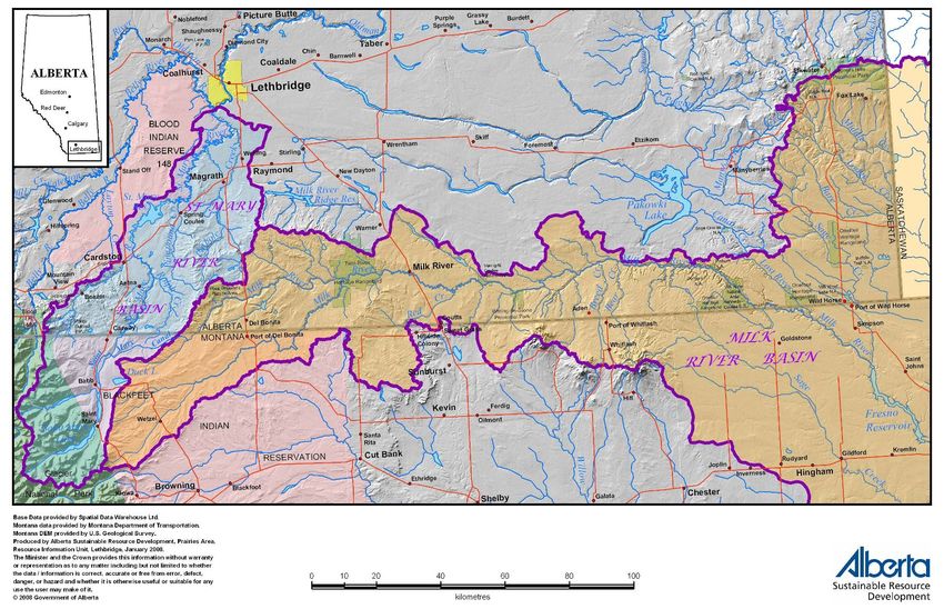
Both the St. Mary and Milk rivers originate in Montana along the eastern slopes of the Rocky
Mountains and flow north and northeast, respectively, into Alberta (Figure 2) (ISMMRAMTF
2006). The St. Mary River discharges into the Oldman River near Lethbridge, Alberta, and
eventually via the South Saskatchewan and Nelson rivers into Hudson Bay. The North Milk
River flows about 90 km through southern Alberta before its confluence with the Milk River,
which continues east parallel to the international boundary for another 235 km before crossing
back into United States (T. Clayton, pers. comm. 2008). It is a tributary of the Missouri River
and eventually drains via the Mississippi River into the Gulf of Mexico. Both the St. Mary and
Milk rivers pass through lowlands that are viable for agriculture, particularly with irrigation.
2.2.1 St. Mary River
The St. Mary River has a total drainage area of about 3 600 km², of which about 2 400 km² is in
Alberta (ISMMRAMTF 2006). The river rises at Gunsight Lake in Montana’s Glacier National
Park and flows northeast about 65 km through St. Mary and Lower St. Mary lakes before
crossing the international border. It then meanders north about 55 km through mainly shrub-
grassland to the St. Mary Reservoir in Alberta. In the United States, the drainage basin receives
about 1 200 mm of precipitation on average annually, mostly as snow (ISMMRAMTF 2006).
Within Alberta the average annual precipitation in this drainage ranges from 470 mm in the
Foothills Fescue Natural Subregion in the south to 394 mm in the Mixedgrass Natural Subregion
in the north (Natural Regions Committee 2006).
Flow in the St. Mary River is maintained during the summer by melt water from the high
elevations of Glacier National Park (ISMMRAMTF 2006). At the international border, the
average monthly flow is < 6 m³/s (cubic metres per second) (or 211 cfs = cubic feet per second)
from December through March (WSC 2008c). Flow increases abruptly in the spring to peak in
June at 73.0 m³/s (2 578 cfs). It then decreases abruptly over the summer and gradually over the
fall. Winter flow is sustained by ground-water base flow. Land use practices that may impair
fish habitat are limited in the St. Mary River drainage in both Montana (Mogen and Kaeding
2005a) and Alberta.
Lee Creek is a small tributary stream of the St. Mary River (Mogen and Kaeding 2005b). The
creek originates in Montana as snow melt and flows north 13 km before crossing the
international border. It then meanders 64 km through the mostly shrub-grassland habitat of
southern Alberta before entering the St. Mary River, near the town of Cardston, upstream from
the St. Mary Reservoir. The average monthly flow in Lee Creek at Cardston rarely exceeds 1
m³/s (35 cfs) from August through February (WSC 2008a). Flow increases over the spring to
peak in June at 5.77 m³/s (204 cfs) and then declines abruptly back to the seasonal low flow
values by August. Timber is harvested from parts of the Lee Creek drainage on the Blackfeet
Reservation in Montana, and along its Tough Creek tributary in Alberta (Mogen and Kaeding
2005b; T. Clayton, pers. comm. 2008).
3Figure 2. Location of the Milk and St. Mary river basins in Alberta.
4The natural flow regime of the St. Mary River has been altered since ca. 1900, when a diversion
canal with a capacity of 14.2 m³/s (500 cfs), was constructed to carry water from near the
crossing of the international boundary to the vicinity of Magrath, Alberta (ISMMRAMTF 2006).
By 1921, the canal capacity had been increased to 22.7 m³/s (800 cfs). Known as the “Canadian
St. Mary Canal”, it generally operated from April through to the end of October until it was
replaced by the St. Mary Reservoir and a larger canal in the early 1950’s (see also Clements
1973 and English 1977 and Gilpin 2000). Since 1917, water has also been diverted from the St.
Mary River in northwestern Montana via the “St. Mary Canal” into the North Milk River
(ISMMRAMTF 2006). This water flows eastward via the Milk River through southern Alberta
before entering northeastern Montana, where it is used for irrigation.
Water management within the St. Mary and Milk rivers is governed by the 1909 Boundary
Waters Treaty (the Treaty) between the United States and Canada, which is administered by the
International Joint Commission (IJC) (ISMMRAMTF 2006; see also Dolan 2007; Halliday and
Faveri 2007a,b; Rood 2007). Over the past two decades, the St. Mary Canal has transported an
average of about 2.08 x 10⁸ m³ of water annually into the North Fork of the Milk River (U.S.
Bureau of Reclamation 2004). Talks between Canada and the United States to resolve this issue
were ongoing in May 2010. At present the operating capacity of the St. Mary Canal is about 18.4
m³/s (650 cfs), significantly less than its original design capacity of 24.1 m³/s (850 cfs). Montana
plans to replace or rehabilitate the aging canal infrastructure and thereby return the canal to its
original capacity (K. Miller, pers. comm. April 2010; see also Alberta Environment 2004; U.S.
Bureau of Reclamation 2004). This increased capacity would only be used during the period of
peak runoff each year. Its use could lead to a surge of flow into the North Milk and Milk rivers
in June. Studies are planned to examine the effects of higher flows on erosion in Canadian
reaches of both rivers. Sites of particular interest for restoration and/or protection are located at
Hilmer Bridge, north of Del Bonita on the North Milk River, and at Goldsprings Park and Weir
Bridge on the Milk River.
2.2.2 Milk River
The Milk River is a northern tributary of the Missouri-Mississippi Basin, with a 6 500 km²
watershed (http://www3.gov.ab.ca/env/water/basins/BasinForm.cfm?Basins=11). It flows north
from Montana into Alberta, eastward through the southern portion of the province, and then
south back into Montana. The average annual flow entering Alberta is 1.06 x 10⁸ m³ and leaving
Alberta is 1.67 x 10⁸ m³. The Town of Milk River is one of the few communities in the Milk
River Basin.
As the Milk River in Alberta flows east from the Montana Border, it crosses the Foothills
Fescue, Mixedgrass, and Dry Mixedgrass subregions of the Grassland Natural Region (Natural
Regions Committee 2006; Milk River Watershed Council Canada 2008). It flows within the
confines of a defined valley with limited road access. The surrounding land is semi-arid, short
grass prairie that is used primarily for cattle grazing. The river is shallow and turbid, with
dynamic hydraulic conditions and poorly developed riparian zone that lacks higher aquatic plants
due to the highly mobile stream bed (D. Watkinson, pers. comm. 2006). Rainfall in the Milk
River basin averages only 333 mm annually, 72% of which falls during the growing season
(Natural Regions Committee 2006). Periods of high runoff occur briefly in late March and April
5due to snowmelt and in June and July due to intensive, localized rain storms (McLean and
Beckstead 1980).
The Milk River has been severely impacted by changes in its seasonal flow regimes. Water
diverted from the St. Mary River in Montana augments flows in the Alberta portion of the Milk
River from late March or early April through late September or mid-October (ISMMRAMTF
2006). Under natural pre-diversion conditions summer flows in Canada ranged from 1 to 2 m³/s
(35 to 71 cfs) in the North Milk River to between 2 and 10 m³/s (71 and 353 cfs) at the Milk
River’s eastern crossing of the international border (McLean and Beckstead 1980). Since the
diversion, flows in the Milk River at the Town of Milk River have ranged from 10 to 20 m³/s
(353 to 706 cfs) from May to September, and have averaged 15 m³/s (530 cfs) between June and
August. The effects of flow augmentation are much greater in the North Milk River, which has a
relatively small drainage area (238 km² at the North Milk River gauge 11AA001), than they are
downstream at the eastern crossing of the international border, where the river receives runoff
from a much larger area (6 800 km² at gauge 11AA031) (McLean and Beckstead 1980). As the
Milk River flows through Alberta the concentration of suspended sediment in the water
increases, and with it the turbidity (Spitzer 1988). These levels tend to decline over the
augmentation period despite flows that remain fairly constant. Flow augmentation of the Milk
River is actively managed at the St. Mary Diversion Dam in Montana in response to major runoff
events to prevent or reduce erosion, scouring and risk of canal failure, and to optimize use of the
water for irrigation.
When the diversion of water from the St. Mary River is terminated in late September to mid-
October, the river reverts to natural flows for the remainder of the winter season (ISMMRAMTF
2006), albeit within a somewhat modified river channel (McLean and Beckstead 1980; Milk
River Watershed Council Canada 2008). Ramping down of the diverted flow occurs over about a
week, and flows in the river decline over the next several weeks. The decline is most rapid in
upstream reaches of the river. Under severe drought conditions, such as those of 2001-2002,
there may be little or no surface flow and the lower Milk River can be reduced to a series of
isolated pools until spring, although subsurface flows may continue (K. Miller, pers. comm.
2006). At the Town, the average flow rate over the period 1912 to 2006 was less than 2 m³/s (71
cfs) in November and February, and less than 1 m³/s (35 cfs) in December and January (WSC
2008b).
Some areas of the Milk River experience protracted periods with little or no surface flow (K.
Miller, pers. comm.). Upstream from its confluence with the North Milk River to the Montana
Border, surface flow in the Milk River occasionally dries up from July or August until March.
The Milk River mainstem east of Aden Bridge dries up less frequently, perhaps on the order of
every 15 or 20 years; most recently in 1988 and 2001.
2.3 Population and Distribution Context
2.3.1 Distribution
The Rocky Mountain sculpin is only found in North America. It occurs in the upper Missouri
system from Alberta (i.e., the Milk River) south to southern Montana (in the mainstem to at least
6Great Falls), and probably the Bighorn system of Wyoming (D. Neely, pers. comm.). It also
occurs in Alberta’s St. Mary River, which is a headwater tributary of the Nelson River
watershed, and in the lower 24 km of British Columbia’s Flathead River and associated
tributaries, which are part of the Columbia River watershed (Peden and Hughes 1984; D. Neely,
pers. comm.).
Within Alberta, the Rocky Mountain sculpin distribution appears to be limited to the St. Mary
River system above the St. Mary Reservoir, and the upper Milk and North Milk rivers (Figure 3).
It is the only sculpin that occurs in these waters (ASRD 2004). The species’ current distribution
has likely been determined by postglacial dispersal and preference for cooler upstream waters
(ASRD 2004; Fullerton et al. 2004). Its distribution may have changed since the St. Mary Canal
was constructed in 1917, as the canal enabled fish to move downstream from the St. Mary River
into the Alberta portion of the Milk River (Willock 1969).
The sculpin’s Alberta distribution in the St. Mary River system appears to be limited to the lower
35 km of Lee Creek, the lower 500 m of Aetna Creek, and the St. Mary River upstream of the St.
Mary Reservoir (Paetz 1993; R.L.&L. Environmental Services Ltd. 2002; COSEWIC 2005; D.
Watkinson, unpubl. data). Whether the species inhabited lower reaches of the St. Mary River
prior to construction of the reservoir is unknown. However, the abrupt decline in the species’
abundance beginning at the reservoir, suggests that it may have been extirpated from the
reservoir, and possibly from areas downstream. As such the St. Mary Reservoir likely represents
a major obstacle to downstream dispersal of sculpins in the St. Mary River. The reservoir has
very steep banks and almost no littoral zone (English 1977).
Rocky Mountain sculpin occur in the North Milk River from the Alberta/Montana border
downstream to its confluence with the Milk River, and within the Milk River downstream to
within 85 km of the border (Willock 1969; Clayton and Ash 1980; R.L.&L. Environmental
Services Ltd. 1987, 2002; Paetz 1993; ASRD 2004; COSEWIC 2005; T. Clayton and D.
Watkinson, pers. comm. 2008). Tributary use has not been observed as most tributaries of the
North Milk and Milk rivers are ephemeral (T. Clayton, pers. comm. 2007). Since the species was
first reported in the Milk River in the 1960s (Willock 1969), records of its occurrence have been
extended downstream at least 130 km (Clayton and Ash 1980). Whether this a real change in
distribution or a sampling artifact is unknown.
2.3.2 Population Size and Trends
An overall population estimate is not available for the Rocky Mountain sculpin in Alberta, but
the species is abundant in summer and fall in the St. Mary River mainstem upstream from the St.
Mary Reservoir; in the lower 13 km of Lee Creek; in the North Milk River; and in the Milk
River from Deer Creek upstream to the North Milk River confluence (Paetz 1993; R.L.&L.
Environmental Services Ltd. 1987, 2002; P.&E. Environmental Consultants Ltd. 2002; D.
Watkinson, pers. comm. 2010). The genetic and movement data necessary to test for the
existence of discrete subpopulations within the species’ Alberta distribution are unavailable
(COSEWIC 2005).
The sculpin’s abundance is fairly even throughout its Alberta range in the St. Mary River and in
the lower reaches of Lee Creek (R.L.&L. Environmental Services Ltd. 2002; D. Watkinson,
7unpubl. data). From 2006 to 2009, electrofishing of 2 787 habitat quatrates in the St. Mary River
found an average abundance of 0.62 fish/m² in habitats shallower than 1 m (D. Watkinson,
unpubl. data). Prorating these values over the area of suitable habitat from the US border to the
St. Mary Reservoir suggests that this reach of river supports a population of 750 000 Rocky
Mountain sculpins.
Within the Milk River the abundance of Rocky Mountain sculpin appears to decline
progressively downstream from the North Milk River until it is absent near the Pinhorn Ranch.
Despite severe drought conditions in 2001, this sculpin remained one of the most abundant fish
species in some sections of the Milk River in 2002 (P.&E. Environmental Consultants Ltd.
2002). The species is typically more numerous in samples taken during October and November
than July and August, but this is likely an artifact of the higher flow and turbidity conditions
encountered during the summer (T. Clayton, pers. comm. 2008). Rocky Mountain sculpin are
present in the Milk River upstream from the confluence with the North Milk River (D.
Watkinson, pers. comm. 2008), but the species’ abundance there is likely limited by low flow
conditions that occur periodically and can extend from late summer through to spring. The
potential for fish from the St. Mary River to move downstream via the canal into the Milk River
system is a complicating factor in determining population sizes and trends in abundance for both
populations. Elsewhere, the Flathead River in British Columbia may support a substantial
population of Rocky Mountain sculpin (Peden and Hughes 1984). No information is available on
the sizes or trends of populations in the United States.
The Rocky Mountain sculpin has no direct economic importance but it does have intrinsic value
as a contributor to Canada’s biodiversity. Because of its preference for cool waters and clean
substrates this fish may serve as a bio-monitor of environmental conditions in the rivers it
inhabits (ASRD 2004).
8Figure 3. Alberta distribution of the Rocky Mountain sculpin showing key habitat features. Distribution records are from the AESRD Fisheries
and Wildlife Management Information System as of May 2010.
92.4 Biology and Life History
Information on the biology and life history of the Rocky Mountain sculpin in Alberta is available
from studies of the St. Mary River by Roberts (1988) and the Milk River by R.L.&L.
Environmental Services Ltd. (2002), and from ongoing work on both systems by T. Clayton
(Alberta Environment and Sustainable Resource Development) and D. Watkinson (Fisheries and
Oceans Canada). Where gaps remain, information from other sculpin populations that inhabit
similar habitats has been cited. This includes, in particular, work on Rocky Mountain sculpins
that inhabit the West Gallatin River tributary of the Missouri River in southwestern Montana
(Bailey 1952) and the Flathead River of British Columbia (Hughes and Peden 1984; Peden et al.
1989). It may also include information from closely related shorthead and mottled sculpins.
Growth
Rocky Mountain sculpins in the Milk River can grow to at least 114 mm TL (R.L.&L.
Environmental Services Ltd. 2002). Newly hatched young in Montana ranged from 5.8 to 8.1
mm TL, and began feeding at about 9 mm (Bailey 1952). Sculpins in the Flathead River of BC
averaged 19.2 mm total length (TL) by mid-September of their first summer (young-of-the-year,
age 0+) and ranged from 36 to 43 mm TL by the end of their second summer (age 1+) (McPhail
2007). Most males were sexually mature by their third summer (age 2+), and most females by
their fourth summer (age 3+). Young-of-the-year in the St. Mary and Milk rivers appear to grow
faster, attaining lengths of 30 to 40 mm TL by the end of their first summer (age 0+) (Hughes
and Peden 1984; Roberts 1988; D. Watkinson, unpubl. data). This difference does not appear to
be the result of mistaking age 1+ fish for young-of-the-year as suggested by McPhail (2007). The
smallest mature female examined from the St. Mary or Milk rivers was 52.3 mm TL (Roberts
1988).
Reproduction
Gravid female Rocky Mountain sculpin have been observed in the St. Mary River of Alberta in
mid-May at a water temperature of 7.5 °C (Roberts 1988). At the same time, males in the Lee
Creek tributary were guarding eggs in 15°C water. Spawning by sculpins in southwest Montana
has been documented in June at water temperatures ranging from 7.8 to 12.8°C (Bailey 1952).
Fecundity is directly related to size, and ranges from 100 to about 750 eggs per female in the St.
Mary and Milk river populations (Roberts 1988; D. Watkinson, unpubl. data). Rocky Mountain
sculpin in the St. Mary River seldom exceed 87 mm TL, so their egg counts are typically less
than 400. Little else is known about the reproduction of these fish in Alberta.
Based on studies in southwestern Montana, some male sculpins are likely polygynous, having
multiple mates (Bailey 1952). They construct nests under rocks or sometimes on aquatic
vegetation, wood, or debris. Breeding males are dark with a yellow-orange margin on the first
dorsal fin (McPhail 2007). More than one female may be attracted to lay a cluster of adhesive
eggs on the underside of the nest rock, and a single nest can have up to 1 884 eggs (Bailey 1952).
In the nest, the pale yellow to orange-yellow eggs are about 2.5 mm in diameter. After spawning,
the male fans the developing eggs for several weeks to keep them silt-free. The incubation period
is temperature dependant. Based on observations of spawning and hatching dates the incubation
in the West Gallatin River was 21 to 28 days, at afternoon water temperatures that ranged from
107.8 to 17.2°C. Eggs taken artificially and held at temperatures between 8.9 and 10.0°C, began hatching 30 days after fertilization and continued for another 10 days. Absorption of the egg sac takes about two weeks (Bailey 1952). Longevity and spawning periodicity are unknown, but a male sculpin collected in Howell Creek, BC was in its seventh growing season (age 6+) (McPhail 2007), and shorthead sculpins in Idaho (Gasser et al. 1981) spawn annually following maturity. Genetic studies of mottled sculpin suggest that only a small proportion of the potential breeders in a sculpin population may breed successfully in a given year (Fiumera et al. 2002). Hybridization can occur between Rocky Mountain sculpin and slimy sculpin (Cottus cognatus). It has been documented in an area of the Flathead River below a hydroelectric dam where the release of hypolimnetic water has altered thermal regimes and habitat structure (Zimmerman and Wooten 1981; see also Taylor and Gow 2008). Ecological Role Sculpins forage at night and eat mostly bottom-dwelling invertebrates. Young-of-the-year sculpins in southwestern Montana fed mainly on midge larvae (Bailey 1952). As the fry grew, the larvae of other bottom dwelling aquatic insects were added to their diet. During the open water period adult Rocky Mountain sculpins in the St. Mary and Milk rivers ate primarily midge larvae (O. Diptera, F. Chironomidae) and caddisfly nymphs (O. Trichoptera) (D. Watkinson, unpubl. data). They also ate mayfly nymphs (O. Ephemeroptera), nematodes (Ph. Nematoda), invertebrate eggs, trout-perch (Percopsis omiscomaycus), molluscs (Ph. Mollusca), amphipods (O. Amphipoda), water mites (SO. Hydracarina), beetles (O. Coleoptera), and crane fly larvae (F. Tipulidae). Other taxa that have been reported from the adult diet include the molluscs Physa sp. and Pisidium sp., and two fish species, longnose dace (Rhinichthys cataractae) and rainbow trout (Oncorhynchus mykiss) (Bailey 1952; Paetz 1993; Hughes and Peden 1984; ASRD 2004). Adults will eat fry and eggs of their own species (Bailey 1952). Rocky Mountain sculpins in Alberta may be quite sedentary. The estimated home range of sculpins in a small Montana stream was less than 46 m of longitudinal stream channel, with maximum observed dispersal upstream of 180 m and downstream of 153 m (McCleave 1964; see also Bailey 1952). During 1 hour observation periods both small (
The recent identification of trout-perch, yellow perch, walleye, and lake whitefish in the Milk
River system by the MULTISAR (Multi-Species at Risk) Program, a basin-wide terrestrial and
aquatic species identification and stewardship program, suggests that fish may be immigrating
from Montana or that introductions may be occurring (T. Clayton, pers. comm. 2007). Bull trout
and pearl dace (Margariscus margarita) have been entrained in the St. Mary Canal (Mogen and
Kaeding 2002), but have not been reported from the Milk River in Canada. [Note: The Lake
Chub, which is common in both rivers but was not identified among the entrained species, is
sometimes misidentified as pearl dace.] Slimy sculpin (Cottus cognatus) reported by Wells
(1977) from the Milk River were probably misidentified, Rocky Mountain sculpin (Roberts
1988).

Competition of the Rocky Mountain sculpin with other fish species has not been documented in
Alberta. Rocky Mountain sculpins in the Flathead River of British Columbia occupied habitats
downstream from those occupied by slimy sculpin, with little overlap in their distributions
(Hughes and Peden 1984). Likewise, there is little or no distributional overlap of Rocky
Mountain sculpin with the spoonhead sculpin (Cottus ricei), which occurs in the Belly, Waterton,
Oldman and Castle rivers, in Willow Creek, and in the St. Mary River below the St. Mary
Reservoir (T. Clayton, pers. comm. 2007).

Predation of Rocky Mountain sculpin in the Milk and St. Mary rivers has not been documented.
However, garter snakes (Thamnophis sp.) do eat these fish (D. Watkinson, pers. comm.).
Sauger, walleye, northern pike and burbot likely predate various life stages of Rocky Mountain
sculpin, while eggs and larvae may be consumed opportunistically by other fish species.

                                              12
Table 1. Fish species that occur in Canada in the St. Mary River upstream of the St. Mary Dam and/or in the
Milk River, with ranges that overlap (Y) or do not overlap (N) that of the Rocky Mountain
Sculpin; dashes indicate species that have not been reported.
St. Mary River/Lee
Common Name Scientific Name Milk River
Creek
Brassy Minnow Hybognathus hankinsoni ----- Y
Brook Stickleback Culaea inconstans Y Y
Bull Trout Salvelinus confluentus Y -----
Burbot Lota lota Y Y
Cutthroat Trout Oncorhynchus clarkii -----¹ Y
Cutthroat x Rainbow Trout Oncorhynchus clarkii x Y -----
hybrid Oncorhynchus mykiss
Rocky Mountain Sculpin Cottus sp. NA NA
Fathead Minnow Pimephales promelas Y Y
Flathead Chub Hybopsis gracilis ----- Y
Iowa Darter Etheostoma exile ----- N
Lake Chub Couesius plumbeus Y Y
Lake Whitefish Coregonus clupeaformis Y Y
Longnose Dace Rhinichthys cataractae Y Y
Longnose Sucker Catostomus catastomus Y Y
Mountain Sucker Catostomus platyrhynchus Y Y
Mountain Whitefish Prosopium williamsoni Y Y
Northern Pike Esox lucius Y Y
Northern Redbelly Dace Phoxinus eos ----- N
Rainbow Trout Oncorhynchus mykiss Y -----
Sauger Sander canadensis ----- Y
Spottail Shiner Notropis hudsonius Y -----
Stonecat Noturus flavus ----- Y
Trout-perch Percopsis omiscomaycus Y Y
Walleye Sander vitreus Y Y
White Sucker Catostomus commersonii Y Y
Western Silvery Minnow Hybognathus argyritis ----- Y
Yellow Perch Perca flavescens ----- N
¹ Genetically pure cutthroat trout may no longer exist in the St. Mary River.
132.4.1 Habitat
Habitat Preferences
In Alberta, Rocky Mountain sculpin are associated with cool, clear headwaters (Willock 1969).
They tend to be more common in silt-free rocky substrates near stream margins with low to
moderate water velocities than in mid-stream areas where velocities are higher (Paetz 1993)
(Figure 4). Where rocky cover is absent, such as near the Town of Milk River, these fish use
instream sedges and bank-side shrubs that trail in the water for cover.
Figure 4. Rocky Mountain sculpins on gravel substrate (photo credit T. Clayton, AESRD, Lethbridge).
The distribution of Rocky Mountain sculpin in the St. Mary and Milk rivers is strongly correlated
with stream gradient and substrate type (Clayton and Ash 1980; R.L.&L. Environmental
Services Ltd. 2002; D. Watkinson, unpubl. data). During June through October these fish
frequented shallow runs and riffles that contained gravel, cobble, or boulders. Areas with
moderate flow velocities (0.1-1.8 m/s), shallow water (0.1-1.0 m), and mainly gravel and cobble
substrates with thin silt cover (0.0-0.02 m) were preferred (R.L.&L. Environmental Services Ltd.
2002; D. Watkinson, unpubl. data). Young-of-the-year and adults occupied habitat with similar
ranges in flow velocity (< 1.5 m/s), depth, and substrate but proportionately more young-of-the-
year occupied shallower areas with lower water velocities, and silt substrates (D. Watkinson,
pers. comm.). The larger fish showed a slight preference for substrates with more interstitial
spaces (i.e., less embeddedness).
14Rocky Mountain sculpins occupy habitat with water temperatures up to 23.6°C, basic pH in the typical range of 8.0 to 8.6, conductivity of 100 to 920 (μS/cm), turbidity of 0.34 to 10.3 NTU— but typically less than 3.5 NTU, and dissolved oxygen levels of at least 7.4 mg/L (R.L.&L. Environmental Services Ltd. 2002). Turbidity was seldom sufficient to provide visual cover. In the Milk River, there is an abrupt change in gradient at the confluence with Deer Creek (Clayton and Ash 1980). Rocky Mountain sculpins were common upstream of this confluence, where the stream gradient ranges from 1.3 to 7 m/km (0.13% to 0.70%), and absent downstream where the gradient is about 0.65 m/km (0.065%) (Clayton and Ash 1980). They were as common at creek mouths as in the river itself (Willock 1969). Habitat use by specific life stages is not well known. Adults in the Flathead River were abundant in summer at similar water depths and velocities as those used by sculpins in the St. Mary and Milk rivers (McPhail 2007). During the day they sheltered in the substrate and at night emerged to forage along river edges in the shallows (
overwintering habitat in the St. Mary River. Low flow conditions also occur there but are not as
pronounced, with surface flow occurring uninterrupted year-round.

Spawning and rearing habitat are not likely to be limiting for Rocky Mountain sculpins in the
Milk River, since flow augmentation provides a continuous source of fresh, cool water (R.L.&L.
Environmental Services Ltd. 2002). Changes to the current flow regime related to the St. Mary
Diversion could affect the availability of these habitat types in the Milk River but would be less
likely to affect the St. Mary River. Lee Creek would not be affected by changes to the St. Mary
diversion.

Ongoing habitat studies have found Rocky Mountain sculpin to be common and widely
distributed in the St. Mary River, from the International Border to the Highway 5 crossing (D.
Watkinson, pers. comm. 2010). Fish use of the various habitat types is currently being
documented for specific life stages of the Rocky Mountain sculpin.

Habitat Trends and Limitations
Completion of the St. Mary Canal in the United States in 1917 (ISMMRAMTF 2006), and of the
St. Mary Dam and Reservoir in Alberta in 1951 (Gilpin 2000), significantly altered the hydraulic
conditions of both the St. Mary and Milk river systems and thereby the availability of sculpin
habitat. Flow diversion from the St. Mary River has increased seasonal flows in the Milk River
while reducing flows in the St. Mary River. Given the relative size of the systems, the effects
have been more pronounced in the Milk River, where flow has increased ten fold (McLean and
Beckstead 1980). Construction of the St. Mary dam and reservoir replaced lotic (riverine)
habitats with lentic (lake) habitats that are unsuitable for the Rocky Mountain sculpin. Sculpin
have not been reported from the impoundment or downstream, where they may have been
extirpated by habitat degradation and fragmentation. The effects of flow diversion on upstream
reaches of the St. Mary River are less pronounced and have not been quantified for Rocky
Mountain sculpin habitat. Lee Creek is currently unaffected by flow regulation and any flow
diversion is local.

Since 1917, the general character of the Milk River has remained essentially unchanged although
channel widening, increased cut-off activity and higher sediment yield have been documented
(McLean and Beckstead 1980). The effects are most prominent in the smaller channel of the
North Milk River, where the flood frequency has doubled and the magnitude of the flood flows
has increased dramatically since diversion. Flow augmentation continues to erode river banks
and reduce fine-sediment bottom habitats in the Milk River (McLean and Beckstead 1980; D.
Watkinson, pers. comm. 2006).

Habitat availability in the Milk River varies from year to year depending on flow, particularly
when it is not being augmented during late summer, fall, and winter. A water storage dam and
reservoir proposed for a location 30 km upstream from the Town of Milk River is in the very
early planning stages. The impact of such a development has not been assessed but given that
reservoirs are not suitable habitat for the Rocky Mountain sculpin, some adverse effects on the
species should be anticipated. Should they occur, renovations to the St. Mary Canal might alter
flow regimes in the Milk River, affecting sculpin habitat (Alberta Environment 2004; U.S.

                                                16
Bureau of Reclamation 2004). The effects of any habitat alteration on Rocky Mountain sculpin
could be negative or positive.
Habitat Protection
The Rocky Mountain sculpin is afforded varying degrees of direct or indirect habitat protection
through existing statutes and programs.
Federally, the Fisheries Act (R.S. 1985, c. F-14) prohibits carrying on any work or undertaking
that results in the harmful alteration, disruption or destruction of fish habitat except as
authorized by the Minister (S. 35) and similarly prohibits the deposit of deleterious substances
into waters frequented by fish (i.e., fish habitat) (Ss.36.3). The Canadian Environmental
Protection Act (1999, c. 33), which is in place to prevent pollution and protect the environment
and human health, focuses on regulating and eliminating the use of substances harmful to the
environment. The Canadian Environmental Assessment Act (1992, c.37) ensures that prescribed
federal regulatory actions including the authorized destruction of fish habitat are subjected to an
environmental review process. The Species at Risk Act (2002, c.29) prohibits the destruction of
any part of critical habitat once it has been identified in a recovery plan or action plan for any
listed Endangered, Threatened or Extirpated wildlife species (Ss.58.1).
At the provincial level, Alberta’s Wildlife Act (R.S.A. 2000, W-10), requires that the Minister
(responsible for this act) establish an Endangered Species Conservation Committee that will
advise on issues relating to species at risk in Alberta, such as assigning status and preparing and
adopting recovery plans. The Environmental Protection and Enhancement Act
(Chapter/Regulation: E-12 RSA 2000) protects land, water, and air by requiring those operating
or proposing developments to meet their environmental responsibilities. It includes a legislated
environmental assessment process. The Alberta Public Lands Act (R.S.A. 2000, c. P-40) enables
the designation of different types of Crown land use including agricultural, oil and gas and other
resource uses. The Alberta Water Act (Chapter/Regulation: W-3 RSA 2000) focuses on
managing and protecting the province’s water, and regulates the allocation of water resources.
Under the “Water for Life” strategy, Alberta supports the formation of Watershed Planning and
Advisory Councils and the development of Watershed Management Plans. These plans identify
water needs and may influence the licensing of water diversions by the Government of Alberta.
The needs of fish are considered in the development of these plans but fish protection is not their
primary purpose. The Milk River Watershed Council of Canada plans to complete a State of the
Watershed Report in 2008, and a Basin Management Plan 2 years later (T. Clayton, pers. comm.
2008). The Oldman Watershed Council provides advice on water management in the St. Mary
River watershed (S. Petry, pers. comm. 2007).
At writing, 56% of the land bordering the Milk and the North Milk rivers was publicly owned;
the rest was held privately (T. Clayton, pers. comm. 2006). Only 11% of the public and 14% of
the private lands had conservation plans associated with them that included riparian protection.
The remaining land was used mainly for grazing, or for small areas of municipal development
(e.g., Town of Milk River). Six percent of the public land along the river was designated as park
land, for public use and access during the summer but with restrictions on development. Much of
the land bordering Lee Creek (79%) and the St. Mary River (75%) was held privately (T.
17You can also read