An automated UAV-assisted 2D mapping system for First Responders - Zenodo
←
→
Page content transcription
If your browser does not render page correctly, please read the page content below

Enrique Caballero corresponding author et al.                                              Automated UAV mapping for FRs

    An automated UAV-assisted 2D
  mapping system for First Responders

           Enrique Caballero ∗                                                 Angel Madridano
             Drone Hopper,                                                       Drone Hopper,
             Madrid, Spain                                                       Madrid, Spain
    †e.caballero@drone-hopper.com                                         amadrida@drone-hopper.com

            Dimitrios Sainidis                                      Konstantinos Konstantoudakis
       Visual Computing Lab (VCL),                                        Visual Computing Lab (VCL),
  Information Technologies Institute (ITI),                          Information Technologies Institute (ITI),
Centre for Research and Technology - Hellas                        Centre for Research and Technology - Hellas
                 (CERTH),                                                           (CERTH),
           Thessaloniki, Greece ‡                                              Thessaloniki, Greece
            dsainidis@iti.gr                                             k.konstantoudakis@iti.gr

                    Petros Daras                                                   Pablo Flores
       Visual Computing Lab (VCL),                                              Drone Hopper,
  Information Technologies Institute (ITI),                                     Madrid, Spain
Centre for Research and Technology - Hellas                            pablo.flores@drone-hopper.com
                 (CERTH),
            Thessaloniki, Greece
              daras@iti.gr

ABSTRACT

Recent advances in the Unmanned Aerial Vehicles (UAVs) sector have allowed these systems to carry multiple
sensors, thus increasing their versatility and adaptability to a wide range of tasks and services. Furthermore, the
agile performance of these vehicles allows them to adapt to rapidly changing environments making them an effective
tool for emergencies. A single UAV, or a swarm working in collaboration, can be a handy tool for First Responders
(FRs) during mission planning, mission monitoring, and the tracking of evolving risks. UAVs, with their onboard
sensors, can, among other things, capture visual information of the disaster safely and quickly, and generate an
up-to-date map of the area. This work presents an autonomous system for UAV-assisted mapping optimized for FRs,
including the generation of routes for the UAVs to follow, data collection, data processing, and map generation.

Keywords

2D Mapping, UAVs, Swarm, First Responders, Emergency Operations

INTRODUCTION

The high applicability of UAVs in diverse tasks is linked to their ability to carry a wide range of equipment and
sensors in the air quickly. Moreover, it is not only their quick deployment that has led to their expansion but in the
case of rotor-type UAVs such as quadcopters or multirotors their high maneuverability and flexibility to adapt to
different conditions have made them a high-added-value tool for a wide range of sectors such as:
  ∗ corresponding   author
  † https://drone-hopper.com/
  ‡ http://vcl.iti.gr/

                                             WiP Paper – Technologies for First Responders
                             Proceedings of the 18th ISCRAM Conference – Blacksburg, VA, USA May 2021
                                Anouck Adrot, Rob Grace, Kathleen Moore and Christopher Zobel, eds.
Enrique Caballero corresponding author et al.                                             Automated UAV mapping for FRs

    • surveying and mapping (Gutiérrez et al. 2016; Klapa et al. 2019; Park and Jung 2020; Marques Junior et al.
      2020)

    • surveillance and monitoring tasks (Al-Kaff, Gómez-Silva, et al. 2019; Kanistras et al. 2013; Savkin and
      Huang 2019; Y. Li et al. 2019; Al-Kaff, Moreno, Escalera, et al. 2017)

    • search and rescue operations (Kundid Vasić and Papić 2020; Silvagni et al. 2017; Menegol et al. 2018; Ismail
      et al. 2018; Perez-Grau et al. 2017)

    • infrastructure inspections (Al-Kaff, Moreno, San José, et al. 2017; Banić et al. 2019; Choi and E. Kim 2015;
      Ramon-Soria et al. 2019)

    • emergency operations (Zhao et al. 2019; Yang et al. 2018; Panda et al. 2019; Datta et al. 2018; Gkotsis et al.
      2019; Al-Kaff, Madridano, et al. 2020)

    • precision agriculture (Milics 2019; Tsouros et al. 2019; Mogili and Deepak 2018)

    • handling, transport and delivery of materials (Jo and Kwon 2017; Al-Turjman and Alturjman 2020; Song
      et al. 2018)

Nowadays autonomous and teleoperated mobile systems, and in particular UAVs, are being used in emergencies
such as search and rescue missions, monitoring and surveillance. Consequently, research efforts have oriented to
the field of emergency response establishing innovative technologies that will eventually help First Responders
(FRs). However, in many cases, FRs continue to operate with outdated technology which poses a great risk to their
lives and the lives of the victims they are trying to help. Any action that would increase their situational awareness
could have a great impact in crisis response situations. Therefore, it is important to also focus research efforts on
the development of new technologies to improve the security and operational capacity of FRs.
In case of accidents or natural disasters, (explosions, earthquakes, floods, fires) it is impossible to assess the situation
from afar and also very dangerous to send human personnel to the affected location. Hence, having the tools capable
of gathering and presenting information related to the disaster is crucial. UAVs with their on-board cameras and
other sensors, can be deployed, quickly and safely, over a large area to provide real-time visual feed and execute
different tasks such as 2D mapping. With this information at hand, FR teams can establish different strategies to
approach the situation depending on the intelligence provided by the drones.
In this paper we present a pipeline for automated mapping of an area of interest, using either a single UAV or a swarm
of UAVs, tailored for use by First Responders before or during a response operation. This covers mission generation,
optimized flight path calculation for the UAVs, cross-module communication, and orthomosaic map generation.
The presented system requires minimal training and monitoring on the part of FRs, making it appropriate for use in
time-critical circumstances. Used before FR deployment in an area, it can provide a view of the current state, which
may be significantly different from that shown on offline digital maps. This can be invaluable to mission planning
and the safety of both FRs and civilians. Alternatively, it can be used during the course of a mission to monitor both
its progress as well as evolving hazards (e.g. fire, flooding, or road blockages). The presented system was developed
as part of a larger project, the EU-funded FASTER1, which aims to develop innovative technologies for FRs.
The main contribution of this work is to present a UAV-assisted 2D mapping pipeline that is largely automated,
requiring minimal technical knowledge, time and effort on the part of the users. These features aim to make it
suitable for use by FRs before or during their missions when time is essential and personnel focus and effort are at
a premium. In the following pages, we describe each part of the automated pipeline, present the results of early
testing and validation, and discuss future work and improvements
The rest of the document is structured as follows: Section State of Art includes the state of the art on techniques
such as 2D mapping and its application using UAVs; Section Proposal includes the proposal, which establishes the
developments achieved to allow the generation of a 2D map from the visual information captured by the drone’s
camera, as well as the architecture necessary for information exchange between different modules involved in the
operation; Section Testing and validation presents early testing and validation results, including participation in a
large scale multi-disciplinary FR exercise; Finally, section Conclusions and Future Works discusses the conclusions
of the presented work and establishes the future lines of research to convert this work in progress into a crucial
technological tool for the FRs.
   1https://www.faster-project.eu/

                                         WiP Paper – Technologies for First Responders
                         Proceedings of the 18th ISCRAM Conference – Blacksburg, VA, USA May 2021
                            Anouck Adrot, Rob Grace, Kathleen Moore and Christopher Zobel, eds.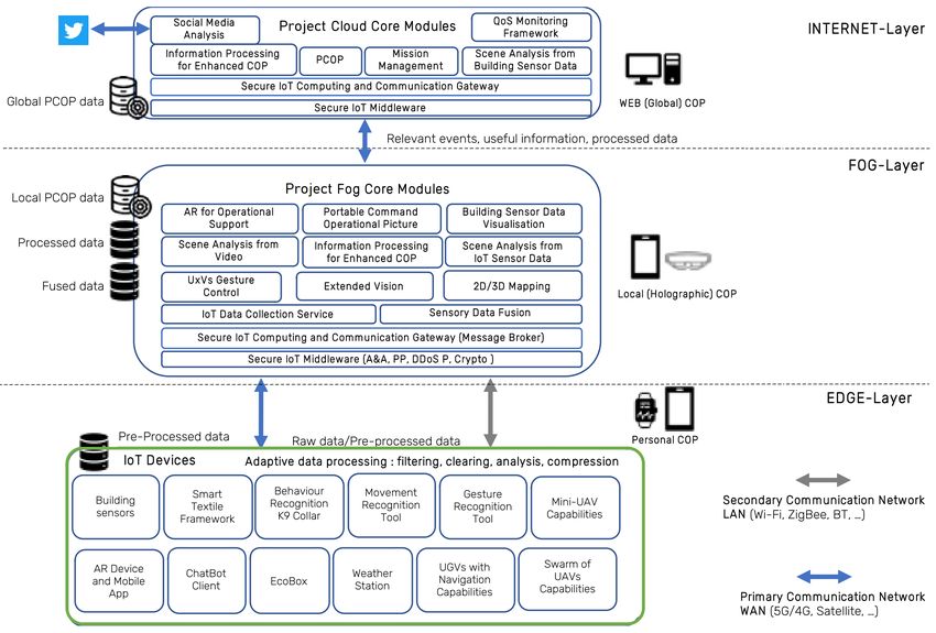
Enrique Caballero corresponding author et al.                                             Automated UAV mapping for FRs

STATE OF ART
The mapping of environments through the use of robotic systems is a growing area of research within robotics and
Artificial Intelligence (AI), and an important aspect in the construction of completely autonomous mobile systems
(Panchpor et al. 2018; Almadhoun et al. 2019; Sualeh and G.-W. Kim 2019).
Acquisition of reliable information about physical objects using UAV photogrammetry has become a widespread
and cost-effective solution (J. Li et al. 2016; Ebolese et al. 2019; Sonnemann et al. 2016). 2D mapping can be
classified as either world-centered or robot-centered. In World-centered 2D mapping, the frame of coordinates
is represented globally and it generates an accurate interpretation of the environment. However, robot-centered
2D mapping is represented in a space of measurements determined by the sensors embarked in the robot thus, its
description will also be according to said measurements (Thrun et al. 2002).
Another classification that the literature collects about mapping methods considers the format of representation
and allows mapping based on grids, features and topology (Wang 2013). Firstly, there is the grid-based map,
which uses discrete cells either occupied or free, to represent the environment and determine the resolution of the
map according to the size of the cell. Higher resolutions allow for more accurate representation, at the cost of
higher computing power. Secondly, there are feature-based maps, which use characteristic points, such as edges,
corners or planes of the environment to generate a representation of the world, with the possibility of adding or
removing features independently. Those maps can be generated by using different sensors simultaneously. This
has the advantage over grid-based maps, of generating a more detailed representation, but the disadvantage of
showing only notable features, which prevents updating the map in cases of high noise density. Finally, there are
the topological-based maps, modeled as a graph in which a node is established for each place in the environment,
and edges or paths are established between them. Their easy construction and use contrast with the difficulties in
obtaining information about obstacles.
In the present work, linked to the FASTER project, another type of cartographic representation is employed, known
as an orthophoto (Habib et al. 2007). This type of representation consists of combining multiple images to generate
a larger one using photogrammetry, a technique to extract depth information from overlapping photographs. This
representation based on the grouping of images does not consist of a simple overlap but uses Structure for Motion
(SfM) (Westoby et al. 2012) to reconstruct the scene and avoids problems arising from a basic overlap, such as
image distortion in areas where the overlap occurs and improving the representation in rough terrain. SfM makes
it possible to eliminate distortions resulting from different perspectives, allowing distances to be preserved and
measurements to be accurate (Chiabrando et al. 2015; Lucieer et al. 2014).
For this work, as detailed in the following section, image acquisition is carried out by a ZED 2 camera2 on board
a UAV and, by using the open-source platform OpenDroneMap (ODM) 3 to be able to generate georeferenced
orthophotos, essential for the generation of 2D maps. The ODM software, based on photogrammetry, is intended
for area mapping using UAVs and allows the generation of orthophotos by extracting the EXIF header from each
image, which contains information about the camera sensor and GPS location. This information coupled with the
SfM-based OpenSfM 4 library, generate a point cloud, which depending on the processing performed can be denser
or more discreet. Finally, a 3D mesh is generated and textured by adding images to the faces of the mesh. A 3D
model is the output of this procedure, and the orthophoto is a top-down projection of the 3D model.

PROPOSAL
The following section describes the different methods and developments that are part of the proposal. First and
foremost, the global architecture developed within the FASTER project is described, the work of which is included
within in this paper. This architecture makes it possible to centralize in a single command post all the information
coming from and to the different agents involved in the operation. In addition, the division of this architecture into
different levels allows the command center to receive only processed data that generate useful information for the
FR teams.
A planning algorithm is also presented, which takes as input the available UAVs, their on-board vision equipment
characteristics, (like sensor size, field of view, etc) and the coordinates of the area of interest and outputs flight paths
for each drone to follow. Those flight paths contain waypoints at which photos must be captured. Those images are
then combined to create 2D map of the affected area which FRs must operate in. To exploit this information and the
UAV swarm technology, we are working on the development of a User Interface that allows the RFs to establish
points of interest on the cartographic representation to send the UAVs to increase the information obtained from a
specific area or to monitor and support the work carried out on the ground.
   2https://www.stereolabs.com/zed-2/
   3https://www.opendronemap.org/
   4https://github.com/mapillary/OpenSfM

                                       WiP Paper – Technologies for First Responders
                       Proceedings of the 18th ISCRAM Conference – Blacksburg, VA, USA May 2021
                          Anouck Adrot, Rob Grace, Kathleen Moore and Christopher Zobel, eds.
Enrique Caballero corresponding author et al.                                        Automated UAV mapping for FRs

Overall System Architecture

The overall FASTER project system architecture is IoT-based, with the principles of scalability and modularity,
having individual modules and services. The main project components: edge devices modules, broker modules,
processing modules and Human Machine Interface Systems modules are depicted in Figure 1. The system includes a
host of technologies and applications for FRs, including drone applications, augmented reality situational awareness,
wearables, communication aids, AI modules, and more, as well as a command center front end to display all data
and provide a front end for various tasks, including UAV mapping.
System components are divided into three layers: The EDGE layer contains modules running on edge devices,
either carried by the first responders or placed in their immediate vicinity. The INTERNET layer is an assortment
of cloud services. The FOG layer is a local cloud network: modules and services that run on devices not carried by
the FRs themselves, but on the local network established in the area of operation. By placing most services on the
FOG layer, connected subsystem can function even without an Internet connection. This makes the overall system
more resilient to connectivity issues that may arise in disaster response scenarios. Inter-module communication is
accomplished via message brokers.
The FASTER project has multiple UAV-related applications, including: extending communication capabilities,
aerial transportation of tools and 2D mapping, among others. UAV applications, as seen in Figure 2, are deployed in
the EDGE Layer, while sensor data is transmitted and processed through the upper layers. Each of the UAVs can
make one or more tasks depending on its architecture. Depending on the sense module, it will forward information
to one FOG module or another. For example, UAVs tasked with mapping will forward the photographs they take to
the 2D mapping module.
The 2D mapping module, presented in this present Work In Progress, has two main submodules (see Figure 3): The
Path Algorithm and the 2D Map Generation. These two will be briefly described below.
When working in tandem these two submodules provide the end user with an effortless experience in creating a
2D map of a desired area. The two submodules are placed on the FOG-Level, but can also be offloaded to the
INTERNET-level, in case of assured connectivity. Hence, they can be installed and run on a remote computer. The
Path Algorithm module listens for a mapping request from the Comand Center, and then calculates the routes for
each drone in the swarm. The 2D Map Generation collects the aerial photographs taken by the UAVs, computes the

                                Figure 1. Overall FASTER project system Architecture

                                      WiP Paper – Technologies for First Responders
                      Proceedings of the 18th ISCRAM Conference – Blacksburg, VA, USA May 2021
                         Anouck Adrot, Rob Grace, Kathleen Moore and Christopher Zobel, eds.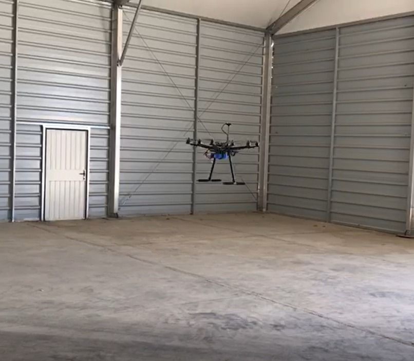
Enrique Caballero corresponding author et al.                                       Automated UAV mapping for FRs

                                          Figure 2. Swarm of Drones scheme

2D map and presents it in the Command Center with accurate GPS coordinates. Mapping requests, UAV waypoints,
photos, and the produced 2D map are exchanged between different modules via the Kafka broker, and include
appropriate metadata to help with their organization, processing, and display. Metadata include a unique mission Id
for each mapping mission, the IDs of UAVs taking part in the mission, GPS coordinates, timestamps, and more.

Path Algorithm

Generating a 2D-map requires the use of Structure from Motion (SfM) algorithm (Westoby et al. 2012), which
takes overlapping images as input and matches features, such as edges, between them. The exact percentage of this
required overlap is not easy to find since it depends on many different variables. To model the desired area, four
spatial coordinates that represent actual points on the Earth’s surface are required. These four points also need to
approximate a rectangle. The desired area is divided into small rectangles that represent the effective footprint
of the drone’s camera. As the effective footprint represents the camera’s footprint with the overlap factored out,
a side-by-side tiling of such rectangles will cover the area of interest with the desired overlap percentage. If the
division is not perfect, it gets rounded up to the next integer. If there is a swarm of drones with different camera

                                            Figure 3. 2D Mapping scheme

                                      WiP Paper – Technologies for First Responders
                      Proceedings of the 18th ISCRAM Conference – Blacksburg, VA, USA May 2021
                         Anouck Adrot, Rob Grace, Kathleen Moore and Christopher Zobel, eds.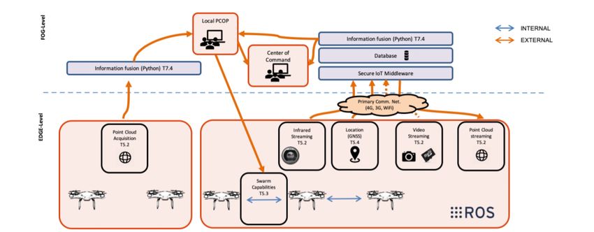
Enrique Caballero corresponding author et al.                                          Automated UAV mapping for FRs

  Figure 4. Path Algorithm: Compute effective footprint based on camera parameters. Tile the plane using effective
  footprint. Round up in needed. Compute centroids of tiles. Create route from one cetroid to the next. Split route
  according to number of drones.

resolutions, the smallest resolution is used for the division to ensure the area is fully covered. Since most drones
have similar sensor sizes, this method, although not the most effective, is simple and sufficient to produce accurate
results. After the division, the centroids of the small rectangles are the waypoints of the mission. Finally, these
waypoints are split continuously into however many drones are available to generate missions for each. After the
mission is generated, each drone has to fly a certain path and take pictures at each waypoint. A schematic overview
of this procedure is presented in Figure 4.

2D Mapping

ODM5 was chosen as the primary tool for 2D mapping firstly because it is an open-source project meaning it is
freely available and highly customizable and secondly because it meets the needs for the project. An exhaustive
exploration of how the parameters affect the result was started, both in terms of the quality of the outputs and in
terms of time needed to run. Early experimentation was performed on WebODM 6, which is the same core engine
with a friendly user interface. In later stager, command line ODM was used, due to it being both more customizable
than WebODM and achieving better performance.
As mentioned previously, ODM is highly customizable, allowing the setting of many different parameters, as
described in OpenDroneMap: The Missing Guide (Toffanin 2019). These parameters not only affect the final output
a range of different ways, they also change significantly the time it takes to run and complete tasks. Understanding
the impact of different parameter sets was a two-step process. Firstly, the theoretical effect of each parameter on the
output was considered, and likely default values were identified for different scenarios. After that, thorough testing
of the most important parameters was carried out, determining the best parameter combinations for achieving
optimal output quality, again in different scenarios.
The parameters assessed include:

    • crop: This attempts to smooth the final orthophoto by removing outliers from the edges of the polygon.
      However is large missions (more than 50 waypoints) it can be beneficial to remove cropping entirely, to lower
      the processing time.
    • mesh-size: It, refers to the number of triangles the final mesh contains. A larger mesh size equates to a
      more detailed 3D model and subsequently a better looking orthophoto in the expense of higher run0rime and
      memory usage.
    • orthophoto resolution: It specifies the final resolution in cm/pixel. For example an area of 100 by 100
      meters and resolution set to 10 cm/pixel produces an orthophoto of 1,000 by 1,000 pixels. This can be
      calculated as follows: 100 meters is 10,000 centimeters so 10,000 / 10 cm/pixel = 1,000 pixels
    • fast-orthophoto: When this option is enabled, the dense point cloud generation, which is an expensive
      process in terms of resources, is skipped. So the final output is computed using only the sparse point cloud.
      Consequently, it should be avoided when modeling areas that require finer detail, such as urban centers.
   5https://github.com/OpenDroneMap/ODM
   6https://github.com/OpenDroneMap/WebODM

                                      WiP Paper – Technologies for First Responders
                      Proceedings of the 18th ISCRAM Conference – Blacksburg, VA, USA May 2021
                         Anouck Adrot, Rob Grace, Kathleen Moore and Christopher Zobel, eds.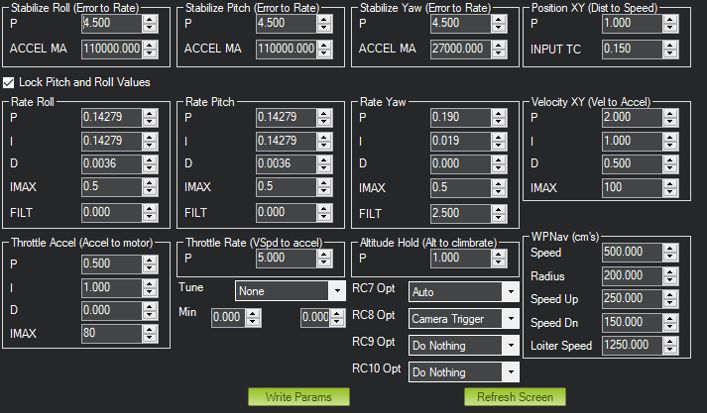
Enrique Caballero corresponding author et al.                                             Automated UAV mapping for FRs

    • resize-to: Resizes the images prior to feature extraction and only for that specific step of the pipeline, without
      affecting the original images nor degrading the final result. Resizing can be used in data-sets with lots of
      distinct features to reduce run-time.
    • min-num-features: Specifies the minimum number of features the algorithm tries to find between images.
      Increasing this option increases the chances of a properly generated reconstruction, whilst also increasing the
      run-time.
    • texturing-nadir-weight: The higher this option is set, the more nadir images are used for texturing vertical
      areas. This is beneficial when lots of buildings exist in the area of interest
Implementation
The presented mapping process is divided into two steps: the flight path calculator and the generation of the 2D map
(orthophoto). Briefly described, the process starts with the Control Center front end sending spatial coordinates of
the affected area to the 2D mapping module. The module then handles all the computing and data collection needed
and finally sends the 2D map in digital form to every member of the First Responder team. First responders, after
receiving the 2D map, can plan and coordinate their rescue mission accordingly.
The estimated time of completion of the whole process is proportional to the size of the desired area and can vary
greatly depending on many factors. Setting up the drone for flight should take a trained user 1 to 2 minutes. Then
the Control Center Application allows for an operator to design a mission in less that a minute. While the drone (or
drones) executes the mission it sends aerial photographs to the mapping module. This depends on the connection
between the controller and the drone, and the upload speed of the network. Good connection and upload speed
could result in all photos being uploaded before the drone lands, however obstacles between the drone and controller
and slow internet connection could result in major delays. Finally the process of 2D mapping generation depends
on a number of factors. Those factors are, the total number of photos, the altitude of the mission (high altitude
photos tend to result in faster 2D mapping generation), the desired resolution of the 2D map (in cm/pixel), and the
difficulty of the desired area. Areas very little distinctive features (such as a large forest, where the scene is repeated
over a large distance) is difficult to reconstruct due to the lack of distinctive features.
All the modules described here need to exchange information with one another to collectively generate a result.
The whole pipeline has been automated for First Responder easiness of use. For information interchange between
modules an Apache Kafka message broker was used. Messages are normally exchanged in JSON format, which
makes them easily readable by different platforms and operating systems.

UAV development
Regarding UAV used for this purpose, the configuration selected was the best one for the intended characteristics:

    • Payload with the following characteristics
          – ZED 2, stereo camera with a Resolution of 3840 x 1080. Depth Field of View (FOV) of 110° (H) x 70°
            (V) x 120° for depth sensing purposes
          – NVIDIA® Jetson Nano™ is a small, powerful computer for embedded applications and AI IoT that
            delivers the power of modern AI. It was implemented in order to perform camera operations and to
            implement future collaboration of UAVs through swarming capabilities.
          – 3D printed in-house Casing to hold both camera and Jetson Nano
    • Autonomy of 15 minutes with payload (more than enough to handle the task of 2D mapping)

                        Component                                Model
                           Motors             Racerstar Racing Edition 2212 BR2212 980KV
                            ESC             30A Brushless Motor ESC For Airplane Quadcopter
                           Frame                                  S550
                           Battery              Desire power V8 Series 4s 6000mAh 30C
                      Flight Controller                     PixHawk Cube 2.1
                         Propellers                          CCWCW 10x4.5
                     Telemetry module               Holybro 433Mhz 915Mhz 500mW
                         RC Module                             Futaba T6K

                                  Table 1. UAV specifications for the intended mission

                                      WiP Paper – Technologies for First Responders
                      Proceedings of the 18th ISCRAM Conference – Blacksburg, VA, USA May 2021
                         Anouck Adrot, Rob Grace, Kathleen Moore and Christopher Zobel, eds.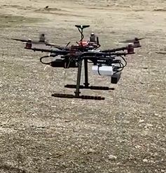
Enrique Caballero corresponding author et al.                                          Automated UAV mapping for FRs

For the correct functioning of the UAV, the necessary flights for the basic parameter setting were performed.

    • Compass calibration and first contact manual flights were performed in the hangar (5).

                                      Figure 5. First Manual Flight in the hangar

    • Adjustment flights were performed in the hangar with favorable results. Flights were performed in AltHold
      (throttle controlled by autopilot to maintain altitude, pilot directly controls the roll and pitch lean angles and
      the heading), PosHold (pilot can control vehicle’s location horizontally and vertically with the control sticks)
      and Loiter (maintain the current location, heading and altitude).

    • Once these modes were verified, a gain adjustment of PIDs (Leva 2018) was performed (Figure 6 depicts
      main tuning parameters configuration )

                                                Figure 6. PID adjustments

    • After installing the payload, deployment was performed at Villanueva del Pardillo airfield with a clear sky,
      temperature at 16ºC and wind speeds between 0 and 3 m/s. A first flight was performed in AltHold mode
      to verify that the payload does not affect the flight capabilities of the aircraft. Subsequently, a flight in
      Loiter mode was performed to verify that the satellite-assisted navigation was correct. Subsequent flights in
      auto-mode with the automatically generated missions (will be described in Testing and validation) were done.
      Some minor corrections over the automatic generation of the mission were made to meet ODM requirements
      (that is, prior to taking photos, always point the aircraft towards geographical north).

                                      WiP Paper – Technologies for First Responders
                      Proceedings of the 18th ISCRAM Conference – Blacksburg, VA, USA May 2021
                         Anouck Adrot, Rob Grace, Kathleen Moore and Christopher Zobel, eds.
Enrique Caballero corresponding author et al. Automated UAV mapping for FRs
Figure 7. Custom UAV ready for a mapping mission during the Figure 8. UAV during takeoff in the
Madrid exercise Madrid exercise
TESTING AND VALIDATION
The proposed mapping system was evaluated in numerous test missions, including a diverse range of mapping
area, altitude, terrain types, and different UAV models. In its most recent version, it participated in a large-scale,
multi-disciplinary FR exercise in Madrid, Spain, on 17 November, 2020, alongside other FR-oriented tools and
approximately 25 local FRs, as well as another 10 FRs from other areas. The proposed solution was the first tool to
be used during the exercise, since it provided an updated map of the disaster zone.
The operational scenario was a devastated area with lack of communications, therefore no internet access was
granted. Local PCOP was deployed, meaning that 2D mapping capability was available. The area to be mapped
consisted on a rectangle (disaster area) of approximately 5,700 m2 . The performance can be seen in Table 2:
Covered Area 5700 m2
Deployment Time 5 minutes
Operation Time 3 minutes
Data Communication Time 3 minutes
Processing Time 10 minutes
Total Time 21 minutes
Table 2. Operation performance
The hexacopter described above was used in this exercise to perform the first assessment of the zone, employing the
automated mapping procedure presented in this work (Figures 9 and 10 depicts operational scenario from that day).
Output from the exercise is shown in Figure 11.
Mapping actions pipeline during the exercise
During the exercise, the progress flow of the mapping tool was the following: in the first step, once the First
Responder has selected the area to be mapped, the flight path calculator obtains an optimum waypoint structure
(i.e a flight plan). The GCS is already waiting for a flight plan therefore it is automatically digested in the format
Mission Planner (GCS software selected) wants to have it.
Figure 9. Automatic obtention of Flight Plan Figure 10. Optimized flight plan and waypoints
After the mission is finished, GCS communicates with UAV’s Jetson Nano in order to download the photos and
upload them to ODM module and when the computations are finished, the orthophoto is displayed
WiP Paper – Technologies for First Responders
Proceedings of the 18th ISCRAM Conference – Blacksburg, VA, USA May 2021
Anouck Adrot, Rob Grace, Kathleen Moore and Christopher Zobel, eds.Enrique Caballero corresponding author et al. Automated UAV mapping for FRs
Figure 11. Generated orthomosaic 2D map
Comments and feedback
During the exercise FR participants shared their impression on the tools used in their operations, including the
presented mapping tool. In the days following the exercise, more in-depth feedback and comments were collected
into a a blog, where the main conclusions were described. Some feedback from the FRs is:
"The drone provided a large number of updates regarding visual casualty and damage information, and the best
points of entry. The Control Center created an updated 2D map of the area. The resulting map was used to plan
where to send search and rescue professionals, and was also useful in identifying infrastructure issues (a tower
with a victim inside was assessed)."7 from ERICAM (Emergency and Immediate Response of the Community of
Madrid);
"Throughout the simulation we had the opportunity to test different technologies. On the one hand, the drones that
flew over the area, which were very useful for a real time reconnaissance of the surface". from ESDP (Spanish
School for Rescue and Detection with Canines)8
During the last debriefing call with the end users, Spanish and Italian partners make a summary of the tool:
"This technology proves to be a great tool for the management of resources, both human and material, thus achieving
greater effectiveness and efficiency in the management of the response that disaster emergency coordinators must
provide. PCOP works without an internet connection providing timely information on a unique frame from local
level on emergency data coming from different sources. Cutting planning and operating time helps saving lives."
"Drones are essential in an emergency scenario because they permit first responders to have an overview of the
area hit from an event, flying over places that could not be reachable otherwise. The criticality arises from the fact
of having to interface with a remote-control system and therefore always maintaining the possibility of being able to
intervene safely on the flight and on the management of the drones."
"The experience using the 2D mapping tool is satisfying and the result is excellent since on the GCOP it’s possible to
view the drone moving on the territory and, in the end, excellent images are obtained to allow effective visualization
of the situation on the ground. Information in real time in order to have a map about the real situation and locate
the rescue dog on the field (collapsed structure in this case)."
"It would be interesting to complement 2D mapping with the use of thermal cameras, a thermographic camera
(infrared or thermal imaging cameras or thermal imagery) which could mark heat sources, making it possible not
only to locate possible survivors, but also victims and possible sources of danger caused by fires. Another suggestion
would be to add a loudspeaker and a microphone and a loud share a message to the victims, this is a functionality
that we usually made in person, but it would be interesting for points of difficult access to use the drone. It is very
useful to be able to discriminate, thanks to Artificial Intelligence, those objects or areas likely to intervene as well
as movements of the ground or detection of human remains that can indicate points where there may be a victim."
Feedback was generally positive, with users highlighting the importance of having an updated on-the-fly map in
disaster response situations. They stressed the necessity of being able to intervene in the middle of a mission, taking
manual control of the UAV. Requested additional features included thermal mapping for improved victim detection,
as well as a UAV-mounted loudspeaker that would allow first responders to issue instructions to civilians. The
collected feedback will be instrumental in designing the future updates of the presented 2D mapping tool.
7http://www.faster-project.eu/sp-blog/2021/02/01/ericam-en-el-piloto-de-madrid/
8http://www.faster-project.eu/sp-blog/2021/02/02/participacion-de-esdp-en-el-piloto-de-madrid/
WiP Paper – Technologies for First Responders
Proceedings of the 18th ISCRAM Conference – Blacksburg, VA, USA May 2021
Anouck Adrot, Rob Grace, Kathleen Moore and Christopher Zobel, eds.Enrique Caballero corresponding author et al. Automated UAV mapping for FRs
CONCLUSIONS AND FUTURE WORKS
This paper shows the development carried out to demonstrate that collaborative UAVs are a powerful and promising
tool in the field of emergencies and natural disasters thanks, among other aspects, to its flexibility and speed to
place in the air a set of on-board sensors that allow, in this case, to acquire updated visual information of a disaster
environment such as an earthquake.
Together with this analysis, the present work collects those developments in path planning and 2D mapping, which
allow, on the one hand, to design the optimal set of trajectories to cover an area of interest completely and efficiently,
depending on the characteristics of the on-board sensors in the UAVs.
On the other hand, to carry out, from the images captured by the UAVs, an overlapping of them to generate an
updated cartographic representation of the disaster environment that provides the FRs with useful and updated
information of the place of the operation.
Finally, the latest advances and developments that allow undertaking, in real scenarios, the complete operation,
together with the results obtained in the first demonstration of this technology, are included.
Regarding future work, there exists the necessity to improve the following aspects:
• Path Algorithm: validate multi-UAV functionality developed by CERTH in next official exercise. To
accomplish this future step:
1. Preparation of one extra multicopter UAVs to validate the pipeline with an 3 UAV operation
2. Make lab tests to all the UAVs with CERTH functionality
3. Integration, calibration and testing of the rest of UAVs
4. Flight tests in the aerodrome
5. Validation of the workflow during pilots and corresponding updated feedback
• UAV development: Make enhancements on UAV architecture. Through testing, one of the legs of UAV’s
landing gear is seen by the camera. ODM algorithm erases unexpected objects on images, but it is still
something to be solved.
• First Responders application: Make an user interface to enable the end users to perform all the activities
without the guidance of technical staff
ACKNOWLEDGMENTS
This research has been supported by the European Commission funded program FASTER, under H2020 Grant
Agreement 833507. In addition, the authors would like to thank Almudena Sanchez and Fernando Fernandez from
ADM-POL (Madrid Municipal Police), Ana Maria Cintora from SUMMA and Susana Izquierdo from ESDP for
their collaboration during the pilot and their diligence.
REFERENCES
Almadhoun, R., Taha, T., Seneviratne, L., and Zweiri, Y. (2019). “A survey on multi-robot coverage path planning
for model reconstruction and mapping”. In: SN Applied Sciences 1.8, p. 847.
Banić, M., Miltenović, A., Pavlović, M., and Ćirić, I. (2019). “Intelligent machine vision based railway infrastructure
inspection and monitoring using UAV”. In: Facta Universitatis, Series: Mechanical Engineering 17.3, pp. 357–
364.
Chiabrando, F., Donadio, E., and Rinaudo, F. (2015). “SfM for orthophoto to generation: A winning approach for
cultural heritage knowledge”. In: The International Archives of Photogrammetry, Remote Sensing and Spatial
Information Sciences 40.5, p. 91.
Choi, S. and Kim, E. (2015). “Image acquisition system for construction inspection based on small unmanned aerial
vehicle”. In: Advanced Multimedia and Ubiquitous Engineering. Springer, pp. 273–280.
Datta, S. K., Dugelay, J.-L., and Bonnet, C. (2018). “IoT based UAV platform for emergency services”. In:
2018 International Conference on Information and Communication Technology Convergence (ICTC). IEEE,
pp. 144–147.
WiP Paper – Technologies for First Responders
Proceedings of the 18th ISCRAM Conference – Blacksburg, VA, USA May 2021
Anouck Adrot, Rob Grace, Kathleen Moore and Christopher Zobel, eds.Enrique Caballero corresponding author et al. Automated UAV mapping for FRs
Ebolese, D., Lo Brutto, M., and Dardanelli, G. (2019). “UAV SURVEY FOR THE ARCHAEOLOGICAL MAP OF
LILYBAEUM (MARSALA, ITALY).” In: International Archives of the Photogrammetry, Remote Sensing &
Spatial Information Sciences.
Gkotsis, I., Kousouraki, A.-C., Eftychidis, G., Kolios, P., and Terzi, M. (2019). “Swarm of UAVs as an emergency
response technology”. In: Risk Analysis Based on Data and Crisis Response Beyond Knowledge: Proceedings
of the 7th International Conference on Risk Analysis and Crisis Response (RACR 2019), October 15-19, 2019,
Athens, Greece. CRC Press, p. 353.
Gutiérrez, G., Erny, G., Friedman, A., Godsey, M., and Gradoz, M. (2016). “Archaeological topography with small
unmanned aerial vehicles”. In: SAA Archaeol. Rec 16, pp. 10–13.
Habib, A. F., Kim, E.-M., and Kim, C.-J. (2007). “New methodologies for true orthophoto generation”. In:
Photogrammetric Engineering & Remote Sensing 73.1, pp. 25–36.
Ismail, A., Tuyishimire, E., and Bagula, A. (2018). “Generating dubins path for fixed wing uavs in search missions”.
In: International Symposium on Ubiquitous Networking. Springer, pp. 347–358.
Jo, D. and Kwon, Y. (2017). “Development of rescue material transport UAV (unmanned aerial vehicle)”. In: World
Journal of Engineering and Technology 5.4, pp. 720–729.
Al-Kaff, A., Gómez-Silva, M. J., Moreno, F. M., Escalera, A. de la, and Armingol, J. M. (2019). “An appearance-based
tracking algorithm for aerial search and rescue purposes”. In: Sensors 19.3, p. 652.
Al-Kaff, A., Madridano, Á., Campos, S., Garcıa, F., Martın, D., and Escalera, A. de la (2020). “Emergency Support
Unmanned Aerial Vehicle for Forest Fire Surveillance”. In: Electronics 9.2, p. 260.
Al-Kaff, A., Moreno, F. M., Escalera, A. de la, and Armingol, J. M. (2017). “Intelligent vehicle for search, rescue
and transportation purposes”. In: 2017 IEEE International Symposium on Safety, Security and Rescue Robotics
(SSRR). IEEE, pp. 110–115.
Al-Kaff, A., Moreno, F. M., San José, L. J., Garcıa, F., Martın, D., Escalera, A. de la, Nieva, A., and Garcéa, J. L. M.
(2017). “VBII-UAV: Vision-based infrastructure inspection-UAV”. In: World Conference on Information Systems
and Technologies. Springer, pp. 221–231.
Kanistras, K., Martins, G., Rutherford, M. J., and Valavanis, K. P. (2013). “A survey of unmanned aerial vehicles
(UAVs) for traffic monitoring”. In: 2013 International Conference on Unmanned Aircraft Systems (ICUAS). IEEE,
pp. 221–234.
Klapa, P., Bożek, P., and Piech, I. (2019). “Charting topographic maps based on UAV data using the image
classification method”. In: Geomatics, Landmanagement and Landscape.
Kundid Vasić, M. and Papić, V. (2020). “Multimodel Deep Learning for Person Detection in Aerial Images”. In:
Electronics 9.9, p. 1459.
Leva, A. (2018). “PID-based controls in computing systems: a brief survey and some research directions”. In:
IFAC-PapersOnLine 51.4, pp. 805–810.
Li, J., Bi, Y., Lan, M., Qin, H., Shan, M., Lin, F., and Chen, B. M. (2016). “Real-time simultaneous localization and
mapping for uav: a survey”. In: Proc. of International micro air vehicle competition and conference, pp. 237–242.
Li, Y., Zhang, Y., and Cai, L. (2019). “Optimal location of supplementary node in UAV surveillance system”. In:
Journal of Network and Computer Applications 140, pp. 23–39.
Lucieer, A., Jong, S. M. d., and Turner, D. (2014). “Mapping landslide displacements using Structure from Motion
(SfM) and image correlation of multi-temporal UAV photography”. In: Progress in Physical Geography 38.1,
pp. 97–116.
Marques Junior, A., Maria De Castro, D., Guimarães, T. T., Inocencio, L. C., Veronez, M. R., Mauad, F. F., and
Gonzaga Jr, L. (2020). “Statistical assessment of cartographic product from photogrammetry and fixed-wing
UAV acquisition”. In: European Journal of Remote Sensing 53.1, pp. 27–39.
Menegol, M. S., Hübner, J. F., and Becker, L. B. (2018). “Coordinated UAV search and rescue application with
JaCaMo”. In: International Conference on Practical Applications of Agents and Multi-Agent Systems. Springer,
pp. 335–338.
Milics, G. (2019). “Application of uavs in precision agriculture”. In: International Climate Protection. Springer,
pp. 93–97.
Mogili, U. R. and Deepak, B. (2018). “Review on application of drone systems in precision agriculture”. In:
Procedia computer science 133, pp. 502–509.
WiP Paper – Technologies for First Responders
Proceedings of the 18th ISCRAM Conference – Blacksburg, VA, USA May 2021
Anouck Adrot, Rob Grace, Kathleen Moore and Christopher Zobel, eds.Enrique Caballero corresponding author et al. Automated UAV mapping for FRs
Panchpor, A. A., Shue, S., and Conrad, J. M. (2018). “A survey of methods for mobile robot localization and
mapping in dynamic indoor environments”. In: 2018 Conference on Signal Processing And Communication
Engineering Systems (SPACES). IEEE, pp. 138–144.
Panda, K. G., Das, S., Sen, D., and Arif, W. (2019). “Design and deployment of UAV-aided post-disaster emergency
network”. In: IEEE Access 7, pp. 102985–102999.
Park, J. K. and Jung, K. Y. (2020). “Construction of 3D Geospatial Information for Development and Safety
Management of Open-pit Mine”. In: Journal of the Korean Society of Surveying, Geodesy, Photogrammetry and
Cartography 38.1, pp. 43–48.
Perez-Grau, F., Ragel, R., Caballero, F., Viguria, A., and Ollero, A. (2017). “Semi-autonomous teleoperation of
UAVs in search and rescue scenarios”. In: 2017 International Conference on Unmanned Aircraft Systems (ICUAS).
IEEE, pp. 1066–1074.
Ramon-Soria, P., Perez-Jimenez, M., Arrue, B., and Ollero, A. (2019). “Planning System for Integrated Autonomous
Infrastructure Inspection using UAVs”. In: 2019 International Conference on Unmanned Aircraft Systems
(ICUAS). IEEE, pp. 313–320.
Savkin, A. V. and Huang, H. (2019). “Asymptotically optimal deployment of drones for surveillance and monitoring”.
In: Sensors 19.9, p. 2068.
Silvagni, M., Tonoli, A., Zenerino, E., and Chiaberge, M. (2017). “Multipurpose UAV for search and rescue
operations in mountain avalanche events”. In: Geomatics, Natural Hazards and Risk 8.1, pp. 18–33.
Song, B. D., Park, K., and Kim, J. (2018). “Persistent UAV delivery logistics: MILP formulation and efficient
heuristic”. In: Computers & Industrial Engineering 120, pp. 418–428.
Sonnemann, T. F., Ulloa Hung, J., and Hofman, C. L. (2016). “Mapping indigenous settlement topography in the
Caribbean using drones”. In: Remote Sensing 8.10, p. 791.
Sualeh, M. and Kim, G.-W. (2019). “Simultaneous localization and mapping in the epoch of semantics: a survey”.
In: International Journal of Control, Automation and Systems 17.3, pp. 729–742.
Thrun, S. et al. (2002). “Robotic mapping: A survey”. In: Exploring artificial intelligence in the new millennium
1.1-35, p. 1.
Toffanin, P. (2019). OpenDroneMap: The Missing Guide. first. UAV4GEO.
Tsouros, D. C., Bibi, S., and Sarigiannidis, P. G. (2019). “A review on UAV-based applications for precision
agriculture”. In: Information 10.11, p. 349.
Al-Turjman, F. and Alturjman, S. (2020). “5G/IoT-enabled UAVs for multimedia delivery in industry-oriented
applications”. In: Multimedia Tools and Applications 79.13, pp. 8627–8648.
Wang, X. (2013). 2D Mapping Solutionsfor Low Cost Mobile Robot.
Westoby, M., Brasington, J., Glasser, N., Hambrey, M., and Reynolds, J. (2012). “‘Structure-from-Motion’
photogrammetry: A low-cost, effective tool for geoscience applications”. In: Geomorphology 179, pp. 300–314.
Yang, T., Li, P., Zhang, H., Li, J., and Li, Z. (2018). “Monocular vision SLAM-based UAV autonomous landing in
emergencies and unknown environments”. In: Electronics 7.5, p. 73.
Zhao, N., Lu, W., Sheng, M., Chen, Y., Tang, J., Yu, F. R., and Wong, K.-K. (2019). “UAV-assisted emergency
networks in disasters”. In: IEEE Wireless Communications 26.1, pp. 45–51.
WiP Paper – Technologies for First Responders
Proceedings of the 18th ISCRAM Conference – Blacksburg, VA, USA May 2021
Anouck Adrot, Rob Grace, Kathleen Moore and Christopher Zobel, eds.You can also read