BROADBAND FCC Is Taking Steps to Accurately Map Locations That Lack Access - Report to Congressional Committees
←
→
Page content transcription
If your browser does not render page correctly, please read the page content below
United States Government Accountability Office
                 Report to Congressional Committees

September 2021
                 BROADBAND

                 FCC Is Taking Steps
                 to Accurately Map
                 Locations That Lack
                 Access
                 Accessible Version

GAO-21-104447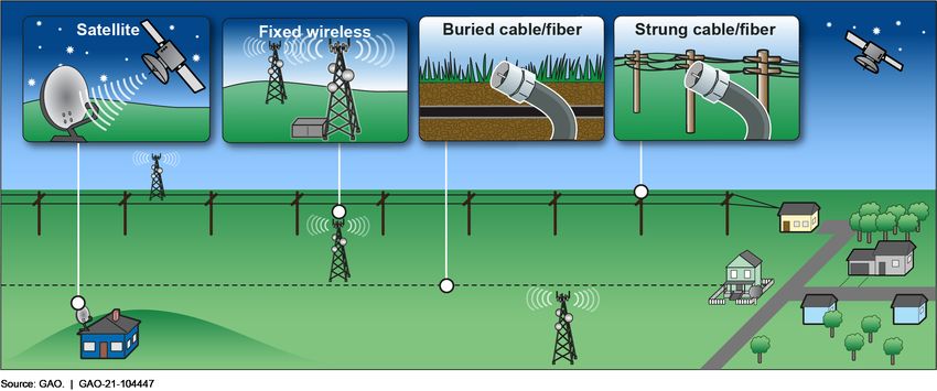
September 2021
GAO Highlight                                BROADBAND
Highlights of GAO-21-104447, a report to     FCC Is Taking Steps to Accurately Map Locations
congressional committees
                                             That Lack Access

Why GAO Did This Study                       What GAO Found
Broadband is critical for commercial,        The Federal Communications Commission (FCC) was tasked in the 2020
educational, and social functions.           Broadband Deployment Accuracy and Technological Availability Act
While most Americans have access to
broadband, many still do not—a gap
                                             (Broadband DATA Act) to create a location fabric, which is a dataset of all
known as the digital divide. To help         locations or structures in the U.S. that could be served by broadband,
close this divide, federal programs          over which broadband deployment data can be overlaid. The purpose of
provide funding to support broadband         this data collection effort is to improve the granularity and precision of
deployment in unserved areas.                FCC’s broadband deployment mapping, which will allow FCC to more
According to FCC, these programs rely        precisely assess where Americans still lack access to broadband. As a
on data FCC collects from broadband
                                             start, FCC has hired a data architect and met with data companies and
providers to identify which areas are
and are not served to target their           states to identify options. FCC has issued a request for proposals for a
limited funds. However, GAO has              product to meet FCC’s location fabric needs. Additionally, FCC officials
raised concerns about FCC’s data for         said that the data company that generates the location fabric will be
lacking accuracy and overstating             responsible for developing a process for state, local, and tribal entities,
service. FCC has been measuring              and others to question and correct fabric location data to improve their
broadband deployment by counting an          accuracy, as required by the law.
entire census block as served if a
provider reports that it offers service to   Stakeholders GAO interviewed identified challenges FCC faces with
at least one location in the census          developing a location fabric, including incomplete or conflicting data
block. This method can overstate the         sources, but said that such challenges can be overcome by using multiple
extent of broadband deployment if the        sources of data. For example, according to stakeholders, there is no one
data show that a census block has
                                             source of location data that will be sufficient for FCC and its contract data
broadband but not all locations in the
census block are actually served. FCC        company to develop a precise location fabric; therefore, it is necessary to
began an effort in 2017 to improve its       integrate four main types of data to have a complete location fabric, as
broadband data, and, in 2020, the            shown in the figure. These data can be sourced from federal, state, local,
Broadband DATA Act required FCC to           and commercial sources. State-level pilots have shown that overlaying
develop a location fabric.                   these data increases the accuracy of the location fabric and addresses
The Broadband DATA Act included a            the limitation that some sources have incomplete data. FCC will need to
provision for GAO to assess key data         manage other challenges as well, such as use restrictions.
sources that may be used to develop a
location fabric. This report (1)             Figure: Mapping Broadband Serviceable Locations Using the Four Key Data Types
describes FCC’s progress in
developing a location fabric; and (2)
describes challenges stakeholders
identified that FCC faces in developing
a location fabric. GAO reviewed
relevant documents; surveyed officials
in 54 states and territories; and
interviewed officials from data
companies, broadband providers,
federal agencies, and states.

View GAO-21-104447. For more information,
contact Andrew Von Ah at (202) 512-2834 or
VonahA@gao.gov.

                                                                                        United States Government Accountability Office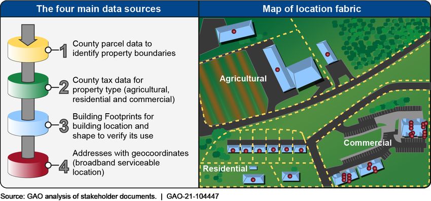
Contents
GAO Highlight                                                                                               2
                                   Why GAO Did This Study                                                   2
                                   What GAO Found                                                           2
Letter                                                                                                      1
                                   Background                                                               5
                                   FCC Has Taken Steps to Develop a Location Fabric, Including
                                     Outreach to Stakeholders and a Request for Proposals from
                                     Potential Contractors                                                10
                                   Stakeholders Identified Limitations with Data and Their Use as
                                     Key Challenges in Developing a Location Fabric                       13
                                   Agency Comments                                                        21
Appendix I: Interviewees                                                                                  23
                                   Data Companies                                                         23
                                   Broadband Providers                                                    23
                                   Telecommunications Industry Associations                               23
                                   States                                                                 23
                                   Other Experts                                                          23
                                   Federal Agencies                                                       24
Appendix II: Selected State Broadband Mapping Efforts                                                     25
Appendix III: Contact and Staff Acknowledgments                                                           28
                                   Contact                                                                28
                                   Staff Acknowledgments                                                  28
Table
                                   Table 1: Selected States with State-Level Broadband Mapping
                                           Efforts, as of June 2021                                       25
Figures
                                   Figure 1: Types of Fixed Broadband                                       6
                                   Figure 2: Comparison of FCC’s Current Census Block Method to
                                            the New Polygon-Reporting Method for Collecting
                                            Broadband Deployment Data                                     10
                                   Figure 3: Mapping Broadband Serviceable Locations Using the
                                            Four Key Data Types                                           17

                                   Page i                                      GAO-21-104447 Broadband Mapping
Page ii GAO-21-104447 Broadband Mapping
Abbreviations
Broadband DATA Act                  Broadband Deployment Accuracy and
                                    Technological Availability Act
COVID 19                            Coronavirus Disease 2019
DOT                                 Department of Transportation
e911                                enhanced 911
FCC                                 Federal Communications Commission
NTIA                                National Telecommunications and
                                    Information Administration
USDA                                U.S. Department of Agriculture
USPS                                U.S. Postal Service

This is a work of the U.S. government and is not subject to copyright protection in the
United States. The published product may be reproduced and distributed in its entirety
without further permission from GAO. However, because this work may contain
copyrighted images or other material, permission from the copyright holder may be
necessary if you wish to reproduce this material separately.

Page iii                                               GAO-21-104447 Broadband Mapping
441 G St. N.W.
Washington, DC 20548
Letter
September 28, 2021
The Honorable Maria Cantwell
Chair
The Honorable Roger Wicker
Ranking Member
Committee on Commerce, Science, and Transportation
United States Senate
The Honorable Frank Pallone, Jr.
Chair
The Honorable Cathy McMorris Rodgers
Republican Leader
Committee on Energy and Commerce
House of Representatives
Access to broadband has become critical for economic opportunity, jobs,
education, and civic engagement—as was highlighted during the
outbreak of the Coronavirus Disease 2019 (COVID 19), when many in-
person activities were replaced by remote activities that relied on
broadband access.1 As we have reported—and media reports continue to
highlight—people in unserved and underserved areas, low-income
families, some minority groups, and tribal communities are
disproportionately affected by a lack of broadband access. This disparity
is often referred to as “the digital divide.” Through programs such as the
Federal Communications Commission’s (FCC) Universal Service Fund
High-Cost Program and the Department of Agriculture’s (USDA)
ReConnect program, the federal government provides funding to expand
broadband infrastructure, in an effort to close the digital divide.
These programs rely on the broadband availability and quality (i.e. speed)
of service data (together “deployment” data) that the FCC collects from
broadband providers to target limited funds to areas with the greatest
need. Specifically, these broadband deployment data show where
broadband is available and where it is not. However, we have previously
reported that FCC’s broadband deployment data for fixed broadband—
1For more information on the COVID-19 pandemic, see GAO, COVID-19: Sustained
Federal Action Is Crucial as Pandemic Enters Its Second Year, GAO-21-387 (Washington,
D.C.: Mar. 31, 2021).
Page 1 GAO-21-104447 Broadband MappingLetter that is, broadband provided to single locations such as customers’ homes or businesses—have overstated existing service.2 In 2014, FCC began collecting broadband availability data by census blocks.3 The agency counts an entire census block as served if a provider reports that it offers service to even one location in the census block. This method can overstate the extent of broadband deployment, since none of the other locations in that census block may be served. This situation is especially the case in rural areas, where a census block can cover a large geographic area. Having accurate deployment data is critical for programs that rely on FCC’s data to make decisions about federal investment to support expanding broadband access. For example, for USDA’s ReConnect program, at least 90 percent of households served by projects receiving a loan or grant through the program must be in a rural area without sufficient access to broadband.4 If the broadband deployment data used to determine whether those areas are eligible for funding are inaccurate, the ability of those programs to effectively target their funding is jeopardized. In other words, inaccurate deployment data raise the potential for too much—or not enough—federal support to be allocated. 2GAO, Broadband Internet: FCC’s Data Overstate Access on Tribal Lands, GAO-18-630 (Washington, D.C.: Sept. 7, 2018) and Broadband: Observations on Past and Ongoing Efforts to Expand Access and Improve Mapping Data, GAO-20-535 (Washington, D.C.: June 25, 2020). Fixed broadband is in contrast to mobile broadband, which is provided by a wireless network wherever a customer has access to a signal and can connect using a mobile device, such as a smartphone. Mobile broadband is not within the scope of this review, as the Broadband DATA Act’s requirements for FCC’s location fabric are specific to fixed broadband services. 3A census block is a statistical area bounded by visible features such as roads, streams, and railroad tracks, and by nonvisible boundaries such as property lines, city, township, school district, county limits, and short line-of-sight extensions of roads. They are the building blocks for which the Census Bureau tabulates data. 4Section 779 of the Consolidated Appropriations Act, 2018 appropriated $600 million to USDA to create a pilot program USDA named the ReConnect Program. The statute requires that at least 90 percent of households served by the program be in a rural area without sufficient access to broadband, defined for this pilot program as 10 Mbps downstream, and 1 Mbps upstream, which shall be reevaluated, as necessary, on an annual basis by USDA. Pub. L. No. 115-141, § 779, 132 Stat. 348, 399. The Consolidated Appropriations Act, 2019, Further Consolidated Appropriations Act, 2020, and the Coronavirus Aid, Relief, and Economic Security Act (CARES Act) each appropriated funds to USDA for the ReConnect Program under the same terms and conditions as the original appropriation. Pub. L. No. 116-6, § 762, 133 Stat. 13, 88; Pub. L. No. 116-94, § 787, 133 Stat. 2534, 2657 (2019); Pub. L. No. 116-136, § 11004, 134 Stat 281, 510 (2020). We have ongoing work to examine the ReConnect program. Page 2 GAO-21-104447 Broadband Mapping
Letter

In 2017, FCC began an effort to improve its broadband deployment data.
In 2020, the Broadband Deployment Accuracy and Technological
Availability Act (Broadband DATA Act) was enacted, requiring FCC to
issue final rules that require twice yearly collection and dissemination of
granular broadband deployment data, and to establish processes through
which the accuracy of the data can be verified.5 The Broadband DATA
Act also required FCC to develop a map-ready dataset (i.e., a dataset
whose information can be integrated onto a map) of all broadband
serviceable locations in the United States and its territories.6 Such a
dataset, which would contain location data that can be used to pinpoint
specific locations in the U.S., is referred to as a location “fabric” in the
Broadband DATA Act and does not show where broadband service is
deployed, as it does not include any deployment data. Rather, it shows all
locations where broadband service could be deployed to provide service,
which we will refer to as broadband serviceable locations.7 This location
fabric, once developed, will serve as the foundation upon which all data
relating to fixed broadband deployment data, which are collected
separately from providers, shall be reported (and, in the case of reporting
that uses shapefiles, overlaid) to show whether there is broadband
access at each specific location.8 This location fabric will represent a
more precise and granular means of mapping existing and needed
broadband deployment sites than would be possible through FCC’s
current maps because the location fabric will show the availability of
broadband to individual locations rather than by Census blocks, as FCC’s
data have previously shown.

The Broadband DATA Act included a provision for us to assess key data
sources used for purposes of the location fabric to identify and geocode
locations where fixed broadband internet access service can be installed.
This report (1) describes FCC’s progress in developing a location fabric;
and (2) describes challenges stakeholders identified that FCC faces in
developing a location fabric.

5Pub.    L. No. 116-130, § 802(a), 134 Stat. 228, 229-30.
6FCC  regulations define broadband internet access service as a mass-market retail
service by wire or radio that provides the capability to transmit data to and receive data
from all or substantially all internet endpoints. 47 C.F.R. § 8.1.
7Broadband    serviceable locations include homes, businesses, or farms, but not locations
like trailheads or buildings where fixed broadband is not needed or may not even be
possible due to a lack of electricity.
8A   shapefile is a file format for storing, depicting, and analyzing geospatial data.

Page 3                                                      GAO-21-104447 Broadband Mapping
Letter

To describe FCC’s progress in developing a location fabric, we reviewed
relevant statutes, regulations, and our prior work related to broadband
mapping, as well as FCC documents and filings in its broadband mapping
proceeding, and FCC documents pertaining to the fabric’s procurement,
such as a request for information about approaches FCC could take in
creating the location fabric. We also interviewed FCC officials on their
progress with developing the location fabric.

To describe stakeholders’ perspectives on the challenges they identified
that FCC faces in developing a location fabric, we:

·   Identified potential geographic data sources from the federal
    government, state governments, and the telecommunications industry
    by reviewing documents from industry and state-sponsored mapping
    pilots and efforts. We then asked the officials associated with these
    data sets, as stakeholders knowledgeable about available relevant
    data, for their perspectives on using similar data sources and
    methodologies for developing a location fabric similar to FCC’s.
·   Surveyed all 50 states, the District of Columbia, and three territories to
    determine whether any states and territories have developed a fabric
    of locations where broadband could be deployed, or broadband
    serviceable locations and if so, what data sources these entities used.
    We identified the state official with broadband leadership
    responsibilities as the person in each state to survey using a list from
    the Department of Commerce’s National Telecommunications and
    Information Administration’s (NTIA) State Broadband Leadership
    Network.9 We pretested the survey with three state broadband
    agencies. We received responses from 44 of these entities,
    representing over an 80 percent response rate.10 To develop the
    survey questions, we conducted initial interviews with state broadband
    officials in Georgia, New York, and South Carolina to discuss their
    experiences with data collection. We also interviewed officials from
    Alabama, Arkansas, Colorado, New Mexico, Pennsylvania, Vermont,
    and Washington, about their experiences as indicated in their survey
    results. Specifically, we interviewed officials from a selection of states

9The  State Broadband Leadership Network is organized by the National
Telecommunications and Information Administration and consisted of state officials from a
variety of state offices, such as the public utility commission and the economic
development office.
10Specifically, we surveyed 54 entities: all 50 states, the District of Columbia, and the
territories of American Samoa, Puerto Rico, and the U.S. Virgin Islands. We received
responses from 41 states, two territories, and the District of Columbia.

Page 4                                                   GAO-21-104447 Broadband Mapping
Letter
that indicated on their survey that they had a location fabric of
broadband serviceable locations. We selected those states whose
responses indicated their mapping approaches might have similarities
to the approach FCC was pursuing. We also reviewed key literature
on the data used for location-fabric development to ascertain the
advantages and disadvantages of different potential location fabric
data sources to identify the key data sources to include on our survey.
We administered the survey from January through April 2021.
· Interviewed officials from FCC, NTIA, and three agencies that
maintain national address databases: (1) the Department of
Transportation (DOT); (2) the U.S. Postal Service (USPS); and (3) the
U.S. Census Bureau. We also conducted semi-structured interviews
with representatives from data companies; broadband providers;
telecommunications industry associations; and other experts.11 We
identified stakeholders with relevant knowledge in broadband
deployment mapping from our prior work that discussed broadband
deployment data and mapping. These stakeholders are listed by
interviewee type in appendix I. We selected the industry providers and
associations to represent both large and small broadband providers of
different types of technologies for providing broadband. Our interviews
with stakeholders are not generalizable to the entire population of
possible stakeholders.
We conducted this performance audit from July 2020 to September 2021
in accordance with generally accepted government auditing standards.
Those standards require that we plan and perform the audit to obtain
sufficient, appropriate evidence to provide a reasonable basis for our
findings and conclusions based on our audit objectives. We believe that
the evidence obtained provides a reasonable basis for our findings and
conclusions based on our audit objectives.
Background
American consumers receive fixed broadband service from
telecommunications companies that own and operate cable, fiber,
terrestrial fixed-wireless technologies, or satellite technologies that
provide broadband access to single locations such as customers’ homes
11We spoke to three other experts in order to gain more background and context. One of
these stakeholders researches broadband policy, another stakeholder is an academic who
leads geospatial information projects, and the third advocates on behalf of communities to
improve their broadband access.
Page 5 GAO-21-104447 Broadband MappingLetter
or businesses (see fig. 1). Such service typically ensures quick
availability. In 2015, the FCC updated its fixed broadband benchmark
speed for advanced telecommunications capability to 25 megabits per
second when downloading and 3 megabits per second when uploading,
or “25/3 Mbps.”12
Figure 1: Types of Fixed Broadband
As broadband use has increased, the federal government has
emphasized the importance of ensuring Americans have access to
broadband. For example, FCC is required to determine whether
advanced telecommunications capability such as broadband is being
deployed to all Americans in a reasonable and timely fashion on an
annual basis.13 One focal point in this effort to ensure Americans have
access to broadband has been the desire to close the “digital divide,”
between those who have access to the social and economic benefits that
broadband can provide and those who do not. As we have reported,
people disproportionately affected by this lack of broadband access often
12FCC made this update as part of its annual inquiry into whether “advanced
telecommunications capability is being deployed to all Americans in a reasonable and
timely fashion” pursuant to Section 706 of the Telecommunications Act of 1996 (codified
at 47 U.S.C. § 1302(b)).
1347 U.S.C. § 1302(b).
Page 6 GAO-21-104447 Broadband MappingLetter live in rural or economically disadvantaged areas where low returns on investment have not attracted new or expanded broadband infrastructure deployments by providers.14 Furthermore, after March 2020, the effects of the digital divide increased with the outbreak of COVID-19 in the United States. The limitations placed on large gatherings caused many Americans to rely solely upon broadband internet to continue their jobs, schooling, and socializing. For those Americans without broadband, or those who must deal with unaffordable or under-performing broadband service, the effect of these limitations was magnified. Working to close the digital divide, a number of federal agencies provide funding for broadband deployment to areas that are unserved and underserved by broadband—in other words, those areas of the country that do not have any internet service at all or the service available is slower than the current broadband benchmark speed. FCC’s Universal Service Fund is the largest program, which includes components designed to ensure access to affordable communications for schools, libraries, rural health care providers, low-income consumers, and those in rural and high-cost areas. The largest component of the Universal Service Fund is the high-cost program—which includes the Connect America Fund and the Rural Digital Opportunity Fund—that targets financial support to rural high-cost areas for the deployment and maintenance of voice and broadband- capable networks.15 The Connect America Fund distributes about $5 billion to broadband providers annually to reduce the high costs of constructing voice and broadband networks in remote areas. The Rural Digital Opportunity Fund helps to defray broadband provider deployment and maintenance costs in rural areas. Additionally, USDA also supports broadband deployment through grant and loan programs managed by the Rural Utilities Service, including the ReConnect program.16 These efforts 14GAO-18-630 and GAO-20-535. 15Inaddition to the high-cost program, the Universal Service Fund includes programs to serve schools and libraries (E-Rate), low-income households (Lifeline), and healthcare providers (Rural Health Care). 16The USDA Rural Utilities Service has four programs that finance broadband deployment: the Rural Broadband Access Loan and Loan Guarantees Program, the Telecommunications Infrastructure Loans and Loan Guarantees Program, the Community Connect Grants Program, and the ReConnect Program. Many recipients of loans from these programs also receive Universal Service Fund Connect America Fund program subsidies that they use to repay their USDA loans. Page 7 GAO-21-104447 Broadband Mapping
Letter

provide grants and loans to providers in rural areas to offset the costs of
establishing reliable broadband access and maintaining access to high-
speed internet service. A provider may receive funding from more than
one program, such as receiving funding through ReConnect to expand
broadband into an unserved area and support from the FCC’s high-cost
program to offset ongoing costs of providing service.

These programs rely on geographic information about the existing
deployment of broadband for targeting their funds to the areas that need
them most, according to FCC.17 In 2014, FCC began to collect broadband
deployment data for the entire United States. These data report fixed
broadband deployment by census blocks.18 However, we and others have
raised concerns about the methodology that FCC uses to collect the
broadband deployment data.19 Specifically, in 2018, we found that FCC
considers an entire census block to be served if a provider reports that it
does, or could offer, service to at least one household in the census
block. This has led to broadband deployment being overstated, especially
in rural—as well as tribal—areas, because service may not be available in
other locations in the Census block. FCC has also noted this possibility to
overstate service. We recommended that FCC develop and implement
methods for collecting and reporting accurate and complete data on
broadband access, especially on tribal lands where service is known to
be lacking.20 In response, FCC officials said they planned to address this

17Inre Establishing the Digital Opportunity Data Collection; Modernizing the FCC Form
477 Data Program, Second Report and Order and Third Further Notice of Proposed
Rulemaking, 35 FCC Rcd 7460 (2020).
18These  “Form 477 data” are named for the form broadband providers use to submit
information on local services they provide.
19As  described later, the Broadband DATA Act directs FCC to reform the Form 477
collection process in a manner that enables the comparison of data and maps produced
before enactment of the Broadband DATA Act, maintains the public availability of data
relating to the deployment of broadband internet access service, and harmonizes
reporting requirements regarding the deployment of broadband internet access service. §
802(b)(6), 134 Stat. at 235.
20GAO-18-630.    We made three recommendations to FCC in this report: (1) develop and
implement methods for collecting and reporting accurate and complete data on broadband
access specific to tribal lands, (2) develop a formal process to obtain tribal input on the
accuracy of provider-submitted broadband data that includes outreach and technical
assistance to help tribes participate in the process, and (3) obtain feedback from tribal
stakeholders and providers on the effectiveness of a statement FCC made to providers in
2012 on how to fulfill their tribal engagement requirements to determine whether FCC
needs to clarify the agency’s tribal engagement statement. As of August, 2021, FCC had
not implemented these recommendations.

Page 8                                                 GAO-21-104447 Broadband Mapping
Letter

recommendation by targeting data collection in tribal areas through the
agency’s current efforts to improve its deployment data.

In 2019, FCC adopted new data collection and mapping procedures with
the goal of gathering more granular, nationwide data on broadband
deployment.21 This new initiative required that fixed broadband providers
submit data on their coverage in a geospatial form, specifically as
polygons–i.e., shapes whose outlines closely correspond to just the
locations where their broadband is deployed in a specific area. In the
existing FCC data collection, broadband providers report their coverage
to FCC in more general terms, using census blocks to identify where
providers have deployed fixed broadband service. Since then, FCC has
sought to develop a baseline broadband-serviceable location fabric,
which would locate and specify all locations in the United States that
could be served by fixed broadband. In other words, this location fabric
would be a geospatially accurate digital map that would plot broadband
serviceable structures across the country. With the location fabric serving
as a baseline, fixed broadband providers will report their broadband
deployment data in reference to the locations in the fabric, either in the form
of polygons covering locations with service, or by submitting lists
identifying those locations. This will result in a more precise view of which
locations are currently served and unserved by broadband than is
possible with the current census-block reporting approach. Figure 2
illustrates the current approach, where broadband deployment is reported
by census block, as compared to the new approach, where providers
report broadband deployment using polygons that could be laid over a
location fabric.

21NTIA  also has a broadband map called the National Broadband Availability Map, which
is a GIS platform used to visualize and analyze federal, state, and commercial broadband
data sets. This map, however, is not based on an underlying location fabric of serviceable
locations.

Page 9                                                 GAO-21-104447 Broadband Mapping
Letter

Figure 2: Comparison of FCC’s Current Census Block Method to the New Polygon-Reporting Method for Collecting
Broadband Deployment Data

                                       In March 2020, the Broadband DATA Act was enacted and had the effect
                                       of superseding some aspects of FCC’s 2019 effort. The Broadband DATA
                                       Act required FCC to issue final rules on location fabric development and
                                       data collection for fixed broadband deployments using either polygons or
                                       a list of addresses or locations. In response, FCC issued rules in July
                                       2020 on how it will collect location-specific data on broadband
                                       deployment from providers. In December 2020, FCC received $98 million
                                       in appropriations enabling it to carry out its responsibilities under the
                                       Broadband DATA Act.22

                                       FCC Has Taken Steps to Develop a Location
                                       Fabric, Including Outreach to Stakeholders and

                                       22The Broadband DATA Act prohibited FCC from using funds from the Universal Service
                                       Fund programs to pay for any costs associated with implementing the act. Pub. L. No.
                                       116-130, § 805, 134 Stat. at 238.

                                       Page 10                                             GAO-21-104447 Broadband Mapping
Letter
a Request for Proposals from Potential
Contractors
Since receiving appropriations for its efforts, FCC has made progress
toward developing a fabric of broadband serviceable locations by taking a
number of steps.
· In February 2021, FCC established the Broadband Data Task Force,
which it charged with creating and developing the broadband
serviceable locations fabric. FCC then hired a data architect to
address known challenges surrounding the development of an IT
platform for the new location fabric and deployment data from
providers.
· To collect more information on issues related to developing a location
fabric, FCC issued a request for information in March 2021 that asked
interested stakeholders in the telecommunications industry to provide
their perspectives on anticipated project deliverables, contract
requirements, data usage rights, and evaluation criteria. The request
for information also identified specific requirements related to the
location fabric for compliance with the Broadband DATA Act. FCC
officials told us that they hired a project manager, and that this official
is developing a project plan that will coordinate workflow to implement
the Broadband DATA Act.
· In June 2021, FCC issued a request for proposals, which asks data
companies to submit initial products for a fabric of locations for FCC
within 4 months of the contract’s signing date, according to FCC
officials.23 Responses to the request were due on July 1, 2021.
According to FCC officials, the data company that it selects to develop
its location fabric will be given a 1-year contract with the option of
working with FCC for 4 additional years to update the location fabric
with new data at least twice a year, depending on the data sources it
uses. FCC officials said that the data updates and maintenance costs
for the fabric of locations would be built into the procurement contract
over the 5-year period. They said the agency plans to use the rest of
the appropriations to build the other IT platforms associated with the
new collection and assist smaller broadband providers and other
23FCC, Broadband Location Serviceable Fabric Statement of Objectives (Washington,
D.C.: June 1, 2021).
Page 11 GAO-21-104447 Broadband MappingLetter
stakeholders in complying with the new reporting requirements and
challenge processes established for the collection.24
Most of the data companies we spoke with stated that it is possible to
develop solutions to meet FCC’s location fabric needs. These companies
stated that creating a nationwide location fabric would be possible by
integrating commercial datasets that are already in existence. The
companies said that an advantage of a commercial location fabric product
is that their developers have spent resources to compare available
datasets and to harmonize, validate, and refine the data products they
assemble. The data companies also stated that commercial entities are
often better able to continuously update the product. These companies
also said that they have spent a significant amount of time building their
datasets. For example, one data company stated that its dataset required
substantial investment and that the learning curve to identify each of the
sources and join them together was considerable.
In addition to the data companies, there are two state-level location-fabric
development efforts where officials discussed the benefits of purchasing a
map-ready dataset from a data company. For example, the State of
Georgia purchased a product from a data company because state
officials determined that collecting data themselves was too costly and
time consuming, according to Georgia officials. Additionally, US Telecom,
a telecommunications industry association, also purchased its location
fabric from a data company to pilot a method of broadband mapping in
Virginia and Missouri that combined several types of data in a manner
similar to what FCC was tasked to do by the Broadband DATA Act. Even
with these data products, officials from Georgia and US Telecom told us
their state-level efforts have been complicated, long-term, and have
involved significant computing power and labor hours spent integrating
data from multiple sources that were inconsistent or incomplete. Appendix
II includes more information on selected state broadband-mapping efforts
to date.
FCC officials said they have met with data companies and states to learn
from their location fabric development efforts and to inform FCC’s
decisions. Additionally, FCC officials said they will have a process where
state, local, and tribal entities can question or “challenge” location fabric
data to incorporate their feedback as required by the Broadband Data
24We will discuss the challenge process further later in the draft.
Page 12 GAO-21-104447 Broadband MappingLetter
Act.25 This challenge process will allow state, local, and tribal
governments, along with other community organizations and others, to
question and correct any inaccuracies in the data used in FCC’s location
fabric and report data inaccuracies. The data company that produces the
location fabric will also be responsible for incorporating data from the
challenge process as directed by FCC.26
Stakeholders Identified Limitations with Data
and Their Use as Key Challenges in
Developing a Location Fabric
According to Stakeholders, Limitations with Location Data
Are a Challenge but Could Be Addressed by Integrating
Multiple Types of Data
According to stakeholders we interviewed, a key challenge for FCC will
be addressing limitations in the location data for the location fabric. No
single dataset is sufficient for developing a fabric of all locations in the
U.S. where broadband could be deployed, according to the various data
companies, broadband providers, telecommunications industry
associations, and states we interviewed. Many of these stakeholders
identified four key data types that each have advantages and limitations.
However, these stakeholders also told us that when combined in various
ways, these data can create a fabric of all broadband serviceable
locations, and having a combination of data types would help address
limitations with the data, which we describe further below. The four types
of data are:
· Address data. These data contain information typically associated
with locating properties for the purpose of mail delivery or travel. In
some jurisdictions, address data have been enhanced, producing
25The Broadband DATA Act requires FCC to establish a user-friendly challenge process
through which consumers, state, local, and tribal governmental entities, and other entities
or individuals may submit coverage data to FCC to challenge the accuracy of the
coverage maps, any information submitted by a provider regarding the availability of
broadband internet access service, or the information included in the Fabric. Pub. L. No.
116-130, § 802(b)(5), 134 Stat. 228, 233-34 (2020).
26FCC, Broadband Location Serviceable Fabric Statement of Objectives (Washington,
D.C.: June 1, 2021).
Page 13 GAO-21-104447 Broadband MappingLetter
“geocoded” address data. For example, “e911 address data,” are
address data that can be plotted using latitude and longitude
coordinates in geospatial information systems, a process that
improves dispatching of first responders.27 Geocoded address data
are useful to locate specific residences and businesses and associate
them with specific broadband serviceable locations. According to a
broadband mapping expert, addresses must be geocoded using
longitude and latitude information to be useful in location fabric
development.
· Parcel data. Parcel data identify property boundaries associated with
a particular property and are useful for determining which structures
on a property may need or currently receive broadband service.
· County property tax assessor data. These data contain information
about the property taxes and use of a property, such as whether it is
residential, agricultural, or commercial. Tax data can help verify
broadband service needs or current access.
· Building footprints. Building footprint data—or renderings of the
base of building structures—involve imagery taken from orbiting
satellites or aerial craft and may be useful in the location fabric
development and validation process for determining what a building is
based on its size and shape. Building footprints can help with
specifying types of structures and identifying likely broadband access
points on a property. One data company said that the shape, size,
appearance, context, and location of the building footprint should
provide sufficient evidence to determine which buildings require
broadband service and which do not.
Stakeholders from data companies, telecommunications industry
associations, and states we interviewed said that there are completeness,
accuracy, and consistency limitations with each of these types of data.
Completeness. Many of the data companies, broadband providers,
telecommunications industry associations, and state and federal agencies
we interviewed said that address, parcel, and building footprint data are
not always complete with respect to all possible locations. One data
company said that creating its data product required the company to
27Enhanced 911, or e911 location data often include addresses and geocoded data such
as the latitude and longitude of the specific location to assist with 911 first responder
dispatch routing. One data company said that some jurisdictions consider e911 datasets
proprietary and will not share with third parties. For more information, see GAO, Next
Generation 911: National 911 Program Could Strengthen Efforts to Assist States,
GAO-18-252, (Washington D.C.: Jan. 31, 2018).
Page 14 GAO-21-104447 Broadband MappingLetter establish relationships with the over 3,000 county governments as well as hundreds of specialized vendors to develop a complete dataset. According to a data company, there are some locations where there may be little to no available information about some of the structures. Therefore, some broadband serviceable locations may not be readily identified in the data that FCC’s contracted data company acquires from any data collection source of any data type. Several stakeholders pointed out that this is likely the case in some rural or tribal jurisdictions. Further, some jurisdictions—especially in rural and tribal areas—may not possess current data on the number of structures that exist, where precisely the structures are, or what the status of those structures may be, and many of these locations do not use standard addresses or may only have a post office box as a mailing address. Finally, as noted by a data company, some jurisdictions have hand-written records, which are not easily read or digitized, possibly creating gaps in the data that will require investigation and follow-up to complete. Accuracy. Several stakeholders also told us that each of the data types have their own data accuracy issues. One data company said that the quality of jurisdictions’ data is not uniform. Therefore, irregularities may arise in the data due to the way records are kept. For example, the data company mentioned that address data does not always link correctly to the correct broadband serviceable location in rural areas where the mail delivery point may be at the end of the road, or on multi-tenant properties where there are several broadband serviceable locations at one postal address. Further, according to officials from NTIA, geocoding structures is not always a simple process, since different geocoding tools may locate structures at different places. For instance, according to a data company, if a geocoding tool does not have precise longitude and latitude coordinates for a structure, it may estimate the structure’s location in the middle of a nearby road or the relevant piece of land when it might be elsewhere on the property. Therefore, reconciliation would be necessary across geocoded datasets. Moreover, some address data may not be geocoded at all, according to a data company. Meanwhile, in terms of record keeping styles, another data company pointed out that parcel data are not always accurate in terms of boundary lines and are sometimes kept in hard copy, which, when digitized, may show distortions in property boundaries due to book binding.28 These and other possible anomalies may also exist in datasets collected by data companies, requiring the data 28“Book binding” refers to the marrying of pages together, in this case, within a hard-copy volume of a tax assessor record book. The folding of the pages near the bindings will cause the anomalies described. Page 15 GAO-21-104447 Broadband Mapping
Letter

be corrected and standardized in order to improve accuracy before
integrating them into the location fabric, according to data companies.

Consistency. Stakeholders we spoke to stated that there may be
inconsistencies in the data. For example, one reason for inconsistency in
address data is that there is no standard approach for geocoding
addresses. Further, two data companies said that parcel and county tax
data may be reported using a wide variety of unique administrative codes
and other non-standard information that could complicate integrating tax
data with other location data. For example, despite being typically
collected by the same county tax offices, tax data and parcel data may
not always link together. As the data aggregated by the data company
selected by the FCC will likely need to come from multiple sources, each
having different administrative codes and terminologies, these differences
would need to be identified and addressed in order for the data to be
linked together, according to FCC and state officials. For example, one
data company stated that some jurisdictions may have fully digitized and
geocoded data, while others may have only digitized and geocoded
portions of their data or none at all. This will depend on what those
jurisdictions have required from their data collection programs and
maintenance efforts. In integrating multiple datasets with these
differences, the data company retained by FCC will need to develop a
single set of the consistent data elements so that the aggregated data
collection can function as FCC’s data company may expect, according to
FCC and state officials.

A few data companies and states told us it is possible to overcome the
limitations of one data type by combining it with one or more of the other
data types. For instance, many of the completeness issues can be
overcome if current satellite images are available to render building
footprints to identify structures that may not be identified in some
counties’ address, parcel, or property tax data. Likewise, property tax and
parcel data may offer clues as to whether broadband is plausibly needed
at some structures, compensating for the lack of similar information in
address data. Property tax and parcel data may also help to eliminate
discrepancies raised by building footprints where the satellite images are
unclear or are not current. Having multiple data types to rely on can also
improve accuracy through validation between sources. Consistency of
reporting styles, important codes, and terminology, however, may remain
an outstanding issue unless the data company retained by FCC performs
work to harmonize the codes and terminology. Still, according to data
companies and other stakeholders, performing that analysis could be
easier where multiple data types are available.

Page 16                                       GAO-21-104447 Broadband Mapping
Letter
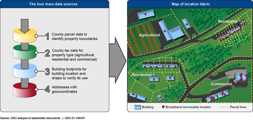
Such an approach has been piloted by some states and US Telecom, the
industry association that piloted a mapping technique as discussed
previously. For example, US Telecom told us that it contracted with a data
company that established a pilot location fabric by layering all four of the
above mentioned data types together in the states of Virginia and
Missouri. First, the data company used parcel data as a foundation to
assess the buildings and property boundaries. Second, the data company
used property tax assessor data to identify general activities at the
property, such as whether it was a residence, business, or farm. Thus,
the assessor data formed the basis for assessing broadband service
needs. Third, the data company analyzed building footprints through
satellite imagery to pinpoint the location of each building that was
expected to need or receive broadband service. Last, address data were
used to allow reference to the location fabric data by outside sources.
When the data did not align, the data company’s personnel visually
reviewed the data sources to manually identify the specific location and
where its geocoordinates should be placed. Figure 3 shows this approach
of identifying broadband serviceable locations using data with geocoded
addresses, parcel boundary lines, county tax data, and building footprints.
Figure 3: Mapping Broadband Serviceable Locations Using the Four Key Data Types
Page 17 GAO-21-104447 Broadband MappingLetter Other pilot location fabrics followed a similar methodology. For example, stakeholders from a different data company said they had recently developed a suite of machine learning algorithms that combines data from all four key types and renders them into a geospatial mapping platform. This company told us that FCC’s need for a highly accurate location fabric depends on integrating the four data types. A further example is the State of Georgia, which used parcel data, geocoded addresses, and building footprints for validation for its state-level location fabric. FCC’s oversight of its contractor will include making sure the contractor addresses these data limitations. FCC’s procurement documents require the data company that develops the location fabric to provide FCC with data quality reports explaining how the data company will use multiple types of data to produce the most accurate location fabric possible.29 The chosen contractor will have to show its product’s data accuracy and the most common errors with both the initial location fabric and estimates for how accuracy might improve over time through the challenge process and other twice-yearly updates. FCC officials said they will be working with their contractor to address such technical issues with the data as well as limitations with using data, as discussed below. Private and Government Use Limitations Will Pose Further Challenges An overarching challenge will be data use limitations, both from commercial and governmental data sources, according to stakeholders. The Broadband DATA Act requires that FCC deliver a publicly accessible version of its nationwide location fabric. Having a public version is also necessary, since the Broadband DATA Act also requires FCC to make the data public for its planned challenge process, in which anyone can challenge data they believe are inaccurate. This process will help ensure providers’ data are accurate and will allow for the opportunity to provide such input on an ongoing basis. However, stakeholders pointed out that many commercial and governmental datasets prohibit unrestricted use of their data. The data company retained by FCC may face the challenge of having to negotiate licensing arrangements and pay fees for the appropriate data rights, if it could acquire them at all. FCC officials told us 29FCC, Broadband Location Serviceable Fabric Statement of Objectives (Washington, D.C.: June 1, 2021). Page 18 GAO-21-104447 Broadband Mapping
Letter

that they are studying the licensing issues and costs across all data
sources.

There are commercial, local, and federal data sources for all four kinds of
data as described above. However, each has its own data use limitations,
according to stakeholders. Commercial data companies do not want
others to gain access to their data for free since their data are their
product. As is typical of commercial datasets, use restrictions may be
directly connected to licensing fees. Negotiations with the companies that
maintain these data will likely focus on protection of the company’s
advantage versus its competitors, according to the three data companies
we interviewed. Moreover, in terms of local and other non-federal
government data, data companies and state officials said that some
jurisdictions may not be able to share their information at all, due to
privacy laws, while others may charge high fees for their data. Each case
may require FCC to develop solutions that will respect local concerns and
prepare contingencies for situations where acquisition is particularly
difficult.

Federal data sources—such as the U.S. Postal Service, the U.S. Census
Bureau, and the U.S. Department of Transportation—could be useful to
FCC as an additional check on the accuracy of data its contractor uses
from local-level sources, but also may have use limitations, according to
federal officials. For example, FCC officials said they would like to work
with Census to improve FCC’s mapping, since Census data could help
ensure reliability of location information. FCC officials have had
discussions with officials from both USPS and Census about their
agencies’ data. Of the three federal data sources that we reviewed, all
have large amounts of information on addresses, but two have data use
limitations, which FCC does not have the authority to override, so they
cannot be used to make a location fabric that must be publicly
accessible.30 Two of the databases we identified possess personally
identifiable information, such as names, and federal law requires that
agencies treat this information as confidential. The two federal address
databases described below could be useful for location fabric
development and validation, but statutory use restrictions pose
challenges for FCC being able to make effective use of them for the
location fabric and any future challenge process.

30The Broadband DATA Act requires that the location fabric be accessible to public
organizations for the challenge process and for broadband providers to report deployment.

Page 19                                               GAO-21-104447 Broadband Mapping
Letter

U.S. Postal Service. The U.S. Postal Service told us that it maintains a
dataset of about 160 million addresses, with a very high percentage of
these having geocoded data. USPS has stated that its dataset is
constantly updated with new addresses and regularly enhanced with geo-
location points that map to mailboxes or front doors. However, federal law
prohibits USPS from disclosing any list of names or addresses of postal
patrons to the public.31 USPS has arrangements with some federal
agencies that allows them to access its address data for validation
purposes, while still not making the full dataset publicly available.32 For
instance, the Department of Housing and Urban Development pays
USPS to license data that helps the department verify the locations of
vacant properties. Further, USPS makes address information products
available to companies that produce commercially marketed validation
apps,33 which at least one state used in its location fabric development
pilot. FCC’s procurement documents included an optional work
requirement to validate address data using the USPS address validation
tool.

U.S. Census Bureau. According to Census officials, the Census
Bureau’s Master Address File and Topologically Integrated Geographic
Encoding and Reference System contains over 155 million addresses,
the majority of which have been geocoded across 14 million unique
geographic areas. This database has also benefited from Census’ close
work with local, state, and tribal authorities to enhance location data on
tribal lands, according to Census officials. However, federal law also
restricts the Census Bureau from sharing these data to protect Census
respondent confidentiality.34

Additionally, DOT maintains the National Address Database, which
contains about 60.5 million residential, business, and other addresses
3139   U.S.C. § 412.
32Through  its authority in 39 U.S.C. § 411, which allows USPS and executive agencies to
furnish property and services to each other, USPS may disclose a list of names or
addresses to another federal agency through interagency agreements that contain a valid
non-disclosure agreement. The interagency agreement must also comply with 5 U.S.C. §
552a(n), which prohibits the sale or rental of an individual’s name and address. 39 C.F.R.
§ 266.3(b)(3)(iii).
3339 C.F.R. § 266.3, USPS may make mailing or other list of names or addresses
available to the public under its authority contained in 39 U.S.C. 401(3) and when the
agreement is subject to a valid non-disclosure agreement.
3413   U.S.C. § 9.

Page 20                                                GAO-21-104447 Broadband Mapping
Letter

and is available to the public.35 However, the database does not include
data for all states. Specifically, the database is comprised of data
submitted by about half (26) of the states, and DOT officials said its role
in the database is limited to compiling address data and that it relies on
the quality control processes established at state, local, or tribal
governments. Nevertheless, the database grows weekly and according to
DOT officials, 10 new participant states were preparing their submissions
as of June 2021. FCC has discussed data sharing with DOT as the
National Address Database has already been published and is available
to FCC for unrestricted use. However, FCC officials said the
incompleteness of this data source makes it less useful since many states
do not report to it.36 Moreover, the Broadband DATA Act requires FCC to
refresh its data at least twice a year, and according to FCC officials, the
National Address Database does not currently include requirements for
participating states to update their data, although DOT officials said a
majority of its state partners update their submitted data either quarterly
or twice a year.

FCC’s procurement documents ask bidders to submit alternative
proposals based on three tiers of data rights with different price points.
According to FCC, this process will allow FCC to balance contract cost
and data use limitations when evaluating the proposals it receives from
data companies before deciding which location fabric product to
purchase.

Agency Comments
We provided a draft of this product to FCC, Census, DOT, NTIA, and
USPS for review and comment. We received technical comments from
FCC, Census, DOT, and USPS, which we incorporated as appropriate.
NTIA did not have any comments.

We are sending copies of this report to the appropriate congressional
committees, the Acting Chair of the FCC, the Secretary of Commerce, the
Secretary of Transportation, the Postmaster General, and other interested

35Recognizingthe need to maintain accurate and up-to-date addresses for transportation
safety, DOT maintains this database as a part of Next Generation 911.
36As we mentioned, the DOT National Address Database contains about 60.5 million
addresses. When compared to the Census’ Master Address File and the Postal Service’s
equivalent, the National Address Database appears to contain significantly fewer
addresses than the other two sources.

Page 21                                              GAO-21-104447 Broadband Mapping
You can also read