Appendix B Technical Supplement to the Economics Discipline Report - Draft Supplemental Environmental Impact Statement
←
→
Page content transcription
If your browser does not render page correctly, please read the page content below
Appendix B
Technical Supplement to the
Economics Discipline Report

          Draft Supplemental Environmental Impact Statement   December 2013
                                                                   Page B-1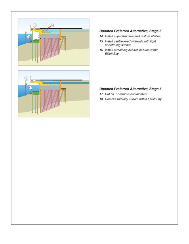
Technical Supplement to the
Economics Discipline Report
                                   FINAL
                     December 2013

                               Submitted to:

                              City of Seattle
              Department of Transportation
                 700 5th Avenue, Suite 3900
                          Seattle WA 98124

                               Prepared by:
                             Tetra Tech, Inc.
TECHNICAL SUPPLEMENT TO THE ECONOMICS DISCIPLINE REPORT
Agreement No. T09-24
FINAL
December 2013
The Elliott Bay Seawall Project is a joint effort between the City of Seattle Department of Transportation
(SDOT), and the U.S. Army Corps of Engineers. To conduct this project, SDOT contracted with:
Tetra Tech, Inc.
1420 5th Avenue, Suite 550
Seattle WA 98101
In association with:
Anchor QEA
BergerABAM
Coast & Harbor
EnviroIssues
Fehr & Peers
Floyd|Snider
GHD
JA Brennan
LPES
Magnusson Klemencic Associates
Mimi Sheridan
Nelson\Nygaard
Northwest Archaeological Associates
Power Engineers
Risk Strategics
Shannon & Wilson
Washington2 Advocates
William P. Ott Construction Consultants
ZGF ArchitectsCity of Seattle
Technical Supplement to the Economics Discipline Report
TABLE OF CONTENTS
Title Page No.
INTRODUCTION ............................................................................................................................. 1
CHAPTER 1. Project Description ....................................................................................................... 3
1.1 Background .................................................................................................................. 3
1.2 Updates to the Preferred Alternative ............................................................................ 3
1.2.1 Seawall ..........................................................................................................................3
1.2.2 Habitat Improvements ..................................................................................................5
1.2.3 Upland Improvements ..................................................................................................5
1.2.4 Construction Schedule ..................................................................................................5
1.2.5 Construction Methods ..................................................................................................6
1.2.6 Construction Sequence .................................................................................................8
CHAPTER 2. Affected Environment................................................................................................. 11
CHAPTER 3. Construction Effects ................................................................................................... 13
3.1 Temporary Employment Impacts during Waterfront Business Closure Period ........... 13
3.1.1 Affected Businesses ....................................................................................................13
3.1.2 Employment Effects of Closure..................................................................................14
3.1.3 Comparison to FEIS ...................................................................................................15
3.2 Evaluation of Loss in Sales Tax Revenue due to Business Closures ............................ 15
3.3 Qualitative Assessment of the Impacts on Local Businesses in Pioneer Square ........... 16
3.3.1 Pioneer Square Profile ................................................................................................16
3.3.2 Effects of the Updated Preferred Alternative ..............................................................17
3.4 Impacts on Local Businesses that Remain Open during Summer Construction .......... 17
3.4.1 Summary ....................................................................................................................18
CHAPTER 4. Operational Effects ..................................................................................................... 21
CHAPTER 5. References .................................................................................................................. 23
LIST OF TABLES
No. Title Page No.
Table 1-1 Proposed Changes to the Preferred Alternative ........................................................................... 4
LIST OF FIGURES
No. Title Page No.
Figure 1-1 Typical construction Sequence for the Updated Preferred Alternative ...................................... 9
December 2013
Technical Supplement to the Economics Discipline Report Page iACRONYMS, ABBREVIATIONS, AND DEFINITIONS AWVRP Alaskan Way Viaduct Replacement Project DEIS Draft Environmental Impact Statement EBSP Elliott Bay Seawall Project FEIS Final Environmental Impact Statement MID/DSA Metropolitan Improvement District/Downtown Seattle Association SDOT Seattle Department of Transportation SEIS Supplemental Environmental Impact Statement SEPA State Environmental Policy Act USGBC U.S. Green Building Council WADOR Washington Department of Revenue December 2013 Page ii Technical Supplement to the Economics Discipline Report
INTRODUCTION
This technical memorandum describes the economic effects of the Updated Preferred Alternative. The
evaluation of effects considers the following:
    •   Limited evaluation of the temporary reduction in employment caused by closure of
        businesses on historic piers during construction, noting whether it is within the range
        described in the Final Environmental Impact Statement (FEIS).
    •   Evaluation of loss in sales tax revenue due to business closures.
    •   Qualitative assessment of the impacts on local businesses in Pioneer Square from seawall
        construction.
    •   Reevaluation of impacts on local businesses that remain open during summer construction
        in terms of economic impacts.
This memorandum focuses on direct local impacts of the Updated Preferred Alternative, which are
different than those described in the FEIS. Along the waterfront, the evaluation is concerned with
economic effects from late May 2014 through the end of construction, or the period in which the
Updated Preferred Alternative’s construction phasing differs from the FEIS. The evaluation of effect on
Pioneer Square begins in July 2014, the earliest point at which traffic revisions differ from the FEIS and
may affect the neighborhood.
The Updated Preferred Alternative is the result of ongoing design refinements and public coordination
since publication of the FEIS. Proposed changes to the Preferred Alternative relevant to economics are
described in the bullets below.
    •   Summer Shutdowns
        –   There will be no summer shutdown during summer 2014 or 2015, and potentially into
            2016. Construction will continue through the summer, but access will be maintained
            and parking provided as feasible.
    •   Business Closures
        –   Most businesses on Piers 54 to 57 will close from October 2014 through June 2015,
            simplifying temporary access requirements during the period. This closure would
            eliminate many challenges related to maintaining pier access across an expansive
            construction zone and would thereby allow construction to proceed more efficiently.
    •   Construction Schedule
        –   Central Seawall construction is anticipated to be substantially complete by mid-2016.
            However, if unanticipated delays were to occur, it is possible that the final construction
            activities could continue after that date until the project is completed.
These changes in the Updated Preferred Alternative drive the evaluation of economic effects described
in the following subsections.

                                                                                         December 2013

Technical Supplement to the Economics Discipline Report                                           Page 1
This page intentionally left blank. December 2013 Page 2 Technical Supplement to the Economics Discipline Report
CHAPTER 1. PROJECT DESCRIPTION
1.1     BACKGROUND
The Elliott Bay Seawall Project (EBSP) Final Environmental Impact Statement (EIS) was published in
March 2013; it evaluated a No Action Alternative and three potential build alternatives for the project.
As required by the Washington State Environmental Policy Act (SEPA), the build alternatives represented
different ways of accomplishing the project purpose of protecting the shoreline and upland areas from
damage due to coastal storms and seismic events, and improving the nearshore ecosystem of Elliott Bay.
The three build alternatives (Alternative A, Alternative B, and Alternative C) encompassed a range of
design ideas to establish “bookends” for the project, thereby capturing a suite of potential options and
effects.
Alternative C was identified by the City as the Preferred Alternative and continued into final design and
construction. Since publication of the FEIS, several changes have been proposed to the project design
and construction methods. The City has determined that the proposed changes have the potential to
result in significant adverse impacts that were not evaluated in the FEIS, and therefore is preparing a
Supplemental Environmental Impact Statement (SEIS) to review only those project elements that have
changed from the Preferred Alternative.
This addendum supplements the Economic Discipline Report from the FEIS. It discusses the potential
impacts on economics from the Updated Preferred Alternative. Material already covered in the FEIS,
including affected environment, impact analysis, and mitigation, is not reproduced in this document.

1.2     UPDATES TO THE PREFERRED ALTERNATIVE
The Preferred Alternative consists of three major components, including a new seawall, improvements
to aquatic habitat, and enhanced upland areas. The Updated Preferred Alternative proposes changes to
two of these components: the seawall and aquatic habitat. The proposed changes are summarized
below; please see Chapter 2 of the SEIS for more detail.
Table 1-1 provides an overview of the differences between the Preferred Alternative and the Updated
Preferred Alternative. Figure 1-1 at the end of this chapter depicts a typical construction sequence for
the Updated Preferred Alternative.

1.2.1 Seawall
The seawall would be replaced as planned under the Preferred Alternative. However, the extent of the
setback would change somewhat in Zones 1 and 2. The 15-foot setback in Zone 1 would be eliminated;
instead, the existing gravity wall would be demolished down to the appropriate level to provide support
for the habitat beach. In Zone 2, the setback would range from 10 to 15 feet landward, similar to the
setback in Zone 3. The setback in all other zones would remain the same.

                                                                                         December 2013

Technical Supplement to the Economics Discipline Report                                          Page 3
1. PROJECT DESCRIPTION
TABLE 1-1 PROPOSED CHANGES TO THE PREFERRED ALTERNATIVE
Project Feature Preferred Alternative Updated Preferred Alternative
Project Design
No setback in Zone 1 and slightly
Seawall improvements 15-foot landward setback in Zone 1
reduced setback in Zone 2
Southern terminus at S. Washington
Roadway improvements Southern terminus at S. Main Street
Street
Modifications to minimize adverse
Extended habitat benches between each effects, accommodate operational
Habitat improvements
of the piers constraints at Colman Dock, and avoid
conflicts with navigation
Construction Schedule
Target completion date: mid-2016
Target completion date: mid-2016
Construction completed Two summer shutdown periods
Work may continue through summers to
(Memorial Day – Labor Day 2014 and
ensure timely completion of the project
2015)
Closure of most businesses on Piers 54
Waterfront business Potential temporary closure of two to 57, currently planned for the nine
closures businesses month off-peak period between October
2014 and June 2015
Temporary access bridges to all piers Reduced number of temporary access
Pier access
required throughout construction bridges during construction
Construction Methods
Ferry-queuing provided on Alaskan Way, Beginning in summer 2014, ferry-
north of Colman Dock, between queuing would switch to south of
Ferry Queuing
Madison Street and Yesler Way Colman Dock, between Yesler Way and
S. Jackson Street
Containment provided by sheet pile,
turbidity curtain, and/or other methods
as feasible and appropriate to protect
Sheet pile containment wall would be water quality
Temporary containment installed prior to jet grouting and
removed at the end of construction
Containment wall would be cut to allow
a portion to remain as vertical support
for the habitat bench in some areas
Geotextile used to support aquatic Geotextile and sheet piles to support
Zone 1 beach stability
materials and increase stability of aquatic materials and increase stability
existing soils of existing soils
Up to continuous dewatering in all
Intermittent dewatering in excavation
Water management excavation areas behind containment
zone landward of existing seawall
wall
December 2013
Page 4 Technical Supplement to the Economics Discipline Report1. PROJECT DESCRIPTION
Project Feature Preferred Alternative Updated Preferred Alternative
Jet grouting from on top of the existing
Jet grouting from on top of the existing
Soil improvement roadway or within the excavated work
roadway prior to excavation
zone in most areas along the seawall
See revised typical construction
Construction sequence See Figure 2-10 in the Final EIS
sequence example in Figure 1-1
1.2.2 Habitat Improvements
In response to conflicts with adjacent uses, the overall extent and design of the expanded habitat
benches would be changed in the Updated Preferred Alternative.
The habitat beach located in Zone 1 is in close proximity to the Washington Street Boat Landing, which is
a historic property listed in the National Register of Historic Places. To minimize the adverse effect to
this property, the size of the beach, height of the confining rock sills, and extent of the riparian plantings
would be slightly reduced. The beach would also be shifted slightly southward to provide a larger
setback from Colman Dock. In addition, aesthetic design elements or treatments may be incorporated
into the natural features of the beach in a form consistent with its purpose to enhance riparian and
intertidal habitat.
To reduce potential conflict with existing boat moorage businesses in Zone 3, the waterward extent of
the expanded habitat bench north of Pier 56 would be reduced. Also in Zone 3, the expanded habitat
bench north of Pier 54 would be removed because it is located on privately owned property.
In Zone 6, the expanded habitat bench north of Pier 69 would be eliminated from the project design to
minimize potential impacts to existing moorage space managed by the Port of Seattle. The expanded
habitat bench north of Pier 66 is being evaluated for its potential to affect future moorage
opportunities.
Despite the changes, the habitat enhancements are still expected to meet the project purpose of
improving the nearshore habitat of Elliott Bay.
1.2.3 Upland Improvements
The Updated Preferred Alternative would not change the project’s upland improvements.
1.2.4 Construction Schedule
Construction of the Central Seawall began in November 2013. Due to the seawall’s importance as
critical infrastructure and as a foundation for other independent waterfront improvement projects, the
City is committed to completing Central Seawall replacement in 2016.
Because project construction is a complex and dynamic process, it is susceptible to schedule changes
due to changed field conditions, availability of materials, extreme weather events, and many other
factors. To ensure that the project is completed on time, construction is now likely to continue through
December 2013
Technical Supplement to the Economics Discipline Report Page 51. PROJECT DESCRIPTION
the summers of 2014 and 2015. The most critical construction activities would continue as needed
during the summer months to recover any time lost to unanticipated schedule delays; additional
efficiencies would also be gained by eliminating the need for demobilization and remobilization.
Summer activities could range from minor utility and roadway work to jet grouting and seawall
reconstruction. The City would strive to minimize impacts on waterfront businesses, residents, and
visitors by limiting summer activities to the greatest extent feasible that is consistent with timely project
completion, and by implementing the access and wayfinding measures described in Chapter 8 of the
Final EIS.
As described in the EIS, access to the piers will generally be provided throughout project construction.
However, most businesses on Piers 54, 55, 56, and 57 are now expected to close for a period of
approximately nine months, currently planned to extend from October 2014 through June 2015. This
closure would eliminate many challenges related to maintaining pier access across an expansive
construction zone and would thereby allow construction to proceed more efficiently. The Great Wheel
and Argosy Cruises would remain open during this period, along with some office spaces (Argosy Cruises
may move its passenger access to nearby piers). Limited access to Piers 54 through 57 would be
provided during the business closure period for those businesses that remain open; access to all
facilities on these piers would be available before and after the closure period. Access to the piers
located outside of the business closure area would be maintained throughout project construction by
way of temporary structures or revised access points.
With these modifications, Central Seawall construction is anticipated to be substantially complete by
mid-2016, the target completion date identified in the EIS. However, if unanticipated delays were to
occur, it is possible that final construction activities could continue after that date until the project is
completed.
1.2.5 Construction Methods
1.2.5.1 Ferry Queuing during Construction
A new access route for Colman Dock is proposed as part of the Updated Preferred Alternative. Beginning
in summer 2014, the U-turn at Madison Street would be eliminated; instead, all ferry-bound traffic
would enter Colman Dock from the south. The new route would provide ferry-queuing spaces on
Alaskan Way to the south. This change would relocate the ferry-queuing lanes to an area outside of the
active work zone, and it could provide more queuing space than the Preferred Alternative. Relocating
ferry-queuing lanes to the south would also provide additional space for parking within the project area.
1.2.5.2 Temporary Containment
Use of the temporary containment wall has changed in two aspects since the FEIS.
• The temporary containment wall would be used where feasible. However, other types of
containment (such as a turbidity curtain) would be used to isolate construction activities
from Elliott Bay when a containment wall is not feasible.
December 2013
Page 6 Technical Supplement to the Economics Discipline Report1. PROJECT DESCRIPTION
• Rather than being removed completely, the containment wall would be cut off just below
the top of the habitat improvements in portions of Zone 4 and Zone 3.
1.2.5.3 Zone 1 Beach Stability
In coordination with Washington State Ferries, an analysis was done to address concerns related to the
protection of Colman Dock from potential instability of the Zone 1 beach. The City concluded that
additional geotechnical reinforcement would be necessary to strengthen the existing sediments and
therefore increase the stability of the habitat beach. Before a geogrid reinforcement is placed, two
parallel rows of sheet pile would be driven into the glacially overridden Quaternary deposits or dense
soils. The geogrid and sheet piles would be buried beneath the mudline. The sheet pile rows would be
positioned beneath the northern slope of the habitat beach, and each row would be approximately 100
to 200 feet in length. Vibratory pile drivers would be used for most of the installation, with only limited
need for impact pile driving. In combination with the geogrid reinforcement, the sheet piles would
stabilize the Zone 1 habitat beach, increasing stability during a seismic event and reducing potential
impacts to adjacent structures.
1.2.5.4 Water Management
To create drier conditions for construction, the contractor has determined that a larger area would be
dewatered. Dewatering generally involves pumping the water to a location where it can be settled
and/or treated before discharge. The water treatment would occur onsite. Due to space limitations,
treatment may be staged on land, as space allows, or on a barge, which would most likely be located at
Piers 62/63 (although its location could change based on construction requirements). Once treated to
meet the water quality requirements specified by the Department of Ecology, the water would be
discharged to Elliott Bay. In some cases, water may be discharged to the King County wastewater
treatment system or disposed of offsite.
1.2.5.5 Soil Improvement
To enhance constructability and overall understanding of site conditions, substantial portions of the
construction work zone would be excavated before jet grouting begins. This technique would reduce the
number of potential obstructions, eliminate void spaces, and provide more reliability for the final jet
grout column layout compared to jet grouting from the roadway surface. Jet grouting would still occur
from the roadway surface in some areas where major excavation is not reasonable.
1.2.5.6 Use of Barges
In addition to the activities described in the FEIS, barges may also be used for staging of some
construction processes. For example, tanks and ancillary water treatment equipment could be placed on
a barge. This would allow these types of operations to occur in close proximity to the project area, but
outside of the confined construction work zone.
December 2013
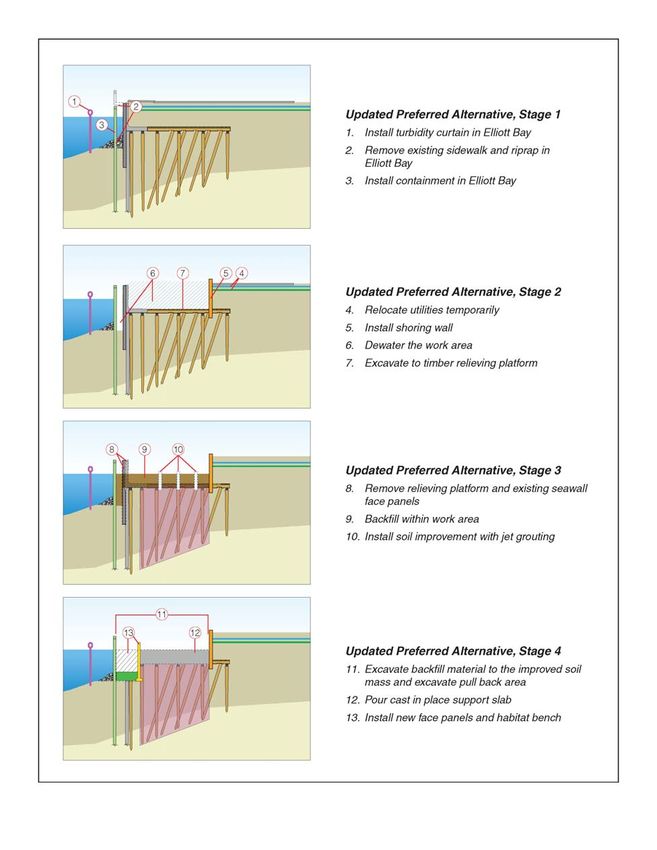
Technical Supplement to the Economics Discipline Report Page 71. PROJECT DESCRIPTION 1.2.6 Construction Sequence As design has progressed and construction techniques have been further developed by the project team and the contractor, a modified construction sequence has been developed to increase efficiency. The main construction steps described in the FEIS will continue to occur, but they may be in a different order in the overall construction sequence. Figure 1-1 provides a typical overview of how the seawall would be built with the revised approach. Construction would generally follow these steps in sequence through the active work zone; however, the sequence and execution would vary between the different seawall types. It is also important to note that not all of the steps would occur at each location, and the construction sequencing may change depending on the site conditions and other factors encountered and evaluated during construction. December 2013 Page 8 Technical Supplement to the Economics Discipline Report
1. PROJECT DESCRIPTION

            Figure 1-1 Typical construction Sequence for the Updated Preferred Alternative

                                                                                       December 2013

Technical Supplement to the Economics Discipline Report                                       Page 9
1. PROJECT DESCRIPTION
Figure 1-1 Typical construction Sequence for the Updated Preferred Alternative (continued)
December 2013
Page 10 Technical Supplement to the Economics Discipline ReportCHAPTER 2. AFFECTED ENVIRONMENT
There are no changes to the affected environment since the FEIS.
December 2013
Technical Supplement to the Economics Discipline Report Page 112. AFFECTED ENVIRONMENT
This page intentionally left blank.
December 2013
Page 12 Technical Supplement to the Economics Discipline ReportCHAPTER 3. CONSTRUCTION EFFECTS
3.1 TEMPORARY EMPLOYMENT IMPACTS DURING WATERFRONT BUSINESS
CLOSURE PERIOD
Temporary employment impacts are evaluated based on a limited evaluation of the temporary
reduction in employment caused by closure of businesses on historic piers during construction, noting
whether it is within the range described in the FEIS. At the time of FEIS preparation, it was assumed that
continuous access to the piers would be provided throughout the project construction, and businesses
would remain open during construction. However, under the current revision to the construction
phasing plan, most businesses on Piers 54 to 57 are now expected to close for a period of approximately
nine months, currently planned to extend from October 2014 through June 2015.
This new closure period constitutes a change from the FEIS. The following discussion evaluates the
economic effects of this new closure period on affected business employment during the 9-month
period currently planned to extend from October 2014 through June 2015.
3.1.1 Affected Businesses
Businesses on Piers 54 through 57 include a mix of offices, retail, food service, and commercial
recreation businesses. Effects on office building tenants/businesses are not evaluated because these
businesses are not expected to be affected by the closure period. The businesses most affected by the
closure period include the food and beverage, restaurant, retail shop, and commercial recreation
businesses on Piers 54 to 57. For the purpose of discussion, these businesses are divided into three
categories: 1) food/dining, 2) retail, and 3) attractions. There is approximately 65,000 square feet of
business space on the piers in these categories, with about 25,000 square feet of retail, 31,500 square
feet of food/dining, and 8,500 square feet of attractions. Attractions are not expected to require
closure.
These businesses draw customers to the waterfront and are especially busy during the peak tourism
season of July through September. Based on information provided by pier owners (Seattle Historic
Waterfront Association 2013), it was estimated that these visitor-dependent businesses capture
approximately 44 percent of their annual revenue during the 3-month peak summer season, and the
remaining 56 percent is captured during the other 9 months of the year.
It was estimated that the food/dining and retail businesses expected to be included in the temporary
closure on Piers 54 through 57 generate between $26 and $43 million in annual revenue1. Based on a
business survey conducted for the FEIS, it was estimated that on average there are between 0.0025 and
0.007 employees per square foot of business space on the waterfront, with a midpoint of 0.00475
employees per square foot. A second source, the Institute of Transportation Engineers (USGBC 2008),
estimated 0.007 employees per square foot, and 0.002 employees per square foot at retail stores. The
1
Based on available data, a range is used to present a conservative analysis.
December 2013
Technical Supplement to the Economics Discipline Report Page 133. CONSTRUCTION EFFECTS Quality Restaurant (Sit Down) category was selected to represent the affected food/dining businesses. This category best reflects the types of businesses in the area, which focus on lunch and dinner and a sit down dining experience and would not be considered fast food or chain restaurants. The Institute of Transportation Engineers’ land use code for Specialty Retail store was selected to represent the retail businesses, as most affected retail shops sell specialty goods and are not chains. Because of the limited number of businesses that responded to the FEIS business survey, both sources were used to estimate employment effects in order to corroborate the estimated effects. 3.1.2 Employment Effects of Closure Based on evaluation of the Updated Preferred Alternative construction phasing, it was estimated that the closure period would affect approximately 51,600 square feet of these businesses, closing 27,000 square feet of food/dining business and 24,600 square feet of retail businesses. These estimates were based on pier maps and basic estimates by business type. Closure of the businesses is expected to last for 9 months, during which affected businesses would not earn revenue, would likely reduce staff levels (keeping only key employees), and would experience a reduction in operating costs (labor, inventory, utilities, etc.). Employment effects would be temporary during the closure period. Businesses would likely reduce staff and maintain the minimum staffing level over the 9-month period. Based on the estimate of affected square footage and the employees per square foot multiplier from the waterfront business survey, it was estimated that the closure period would result in temporary layoff of 245 employees, 128 in food/dining, and 117 in retail jobs in the closure area. Based on the USGBC estimates of employees per square foot by business type, it was estimated that 201 food/dining employees and 45 retail employees would be affected, for a total of 246 affected employees. While the two methods result in slightly different proportions of food/dining and retail effects, the total estimate of effects differs by just one employee between the two estimation methods. It is assumed that some key employees would remain on staff throughout the closure period, while others would be terminated for the duration. It is expected that these job losses would be temporary, and hiring would occur immediately following the closure period. Because terminated employees are likely to look for another job in the food or retail industry during the closure period, employees hired after the closure period may not be the same employees which were terminated. Following the closure period, businesses will reopen beginning July 1, 2015, for peak tourist season. Initially, businesses would need to hire, restock, and prepare for reopening, meaning there may be a period of reduced revenue during the initial ramp-up after the closure period. Also, as noted in the Updated Preferred Alternative description, construction will not cease during the summers of 2014 and 2015. Instead, construction will continue until the project is complete in 2016. During the summer periods, it is expected that construction will take place to the north and south of Piers 54 through 57, and that additional parking spaces will be lined in front of the piers during this period to improve access to the reopened businesses. December 2013 Page 14 Technical Supplement to the Economics Discipline Report
3. CONSTRUCTION EFFECTS

3.1.3 Comparison to FEIS
At the closure period (fall 2014 through spring 2015), effects would be as described above, where
businesses experience lost revenue and temporary reduction in employment. These effects during the 9-
month closure period are estimated to be above and beyond the effect estimated in the FEIS for the
same period.
Following the closure period (summer 2015), differences in the level of effects between the FEIS and the
Updated Preferred Alternative are not expected to be substantial, but may be a net adverse effect.
Though all businesses will be open and access provided, construction will continue through the summers
to the north and/or south of the historic piers (no summer shutdown), which may increase congestion
along the waterfront and reduce business patronage. The additional parking spaces to be added in front
of Piers 54 through 57 will help to improve vehicular access to the businesses.

3.2     EVALUATION OF LOSS IN SALES TAX REVENUE DUE TO BUSINESS
        CLOSURES
The FEIS evaluated the adverse and beneficial sales tax effects on the regional economy from project
construction. In the Updated Preferred Alternative, the business closure period between October 2014
and the end of June 2015 would be expected to result in additional adverse sales tax effects due to
complete closure of a number of businesses that is expected to last for 9 months, rather than the FEIS
assumption which estimated business reduction rather than total closure. This evaluation primarily
considers the effects of the 9-month closure period on sales tax receipts from Piers 54 through 57.
Effects during summer periods are discussed as well.
Sales tax on the waterfront is a combination of state and local taxes. At a total combined rate of 9.5
percent, the sales tax rate reflects the Washington State sales tax rate of 6.5 percent, the City of
Seattle’s tax rate of 2.6 percent, and the Regional Transit Authority’s rate of 0.4 percent (WADOR 2013).
For the purposes of evaluation, it was assumed that sales tax revenue was attributable to the
food/dining, retail, and attraction businesses on the waterfront, as most office space tenants do not
engage in business that would require collection of retail sales tax.
Sales tax effects are expected to be proportional to the effects on revenue during the 9-month closure
period. For businesses that are closed completely, no sales tax revenue is generated during the period.
All businesses expected to close on Piers 54 to 57 would be in the food/dining and retail industries, all of
which would affect sales tax receipts during the closure period.
In order to provide a revenue base for sales tax losses, estimates of the effects on gross receipts were
based on seasonality and the reduction in quantity of business with adjustments for expected reduction
in variable operating costs and reopening costs. The base estimate of lost revenue was between $14 and
$24 million. This value was then adjusted downward based on estimated operating cost savings of
between $3.2 and $5.3 million after accounting for reopening costs. The adjusted adverse impact from
lost revenue over the 9-month closure period could be between $11 and $19 million.
Based on these estimated revenue losses during the closure period, it is expected that sales tax losses
would range from $1.4 million to $2.3 million. Under the construction phasing assumptions of the FEIS,
                                                                                           December 2013

Technical Supplement to the Economics Discipline Report                                            Page 15
3. CONSTRUCTION EFFECTS
sales tax losses would have been approximately $500,000 over the same period for Piers 54 to 57,
making approximately $860,000 to $1.8 million of the closure period sales tax losses over and above the
effects estimated in the FEIS.
In addition to sales tax losses during the closure period, the lack of construction shutdowns during
summer 2014, 2015, and potentially 2016 would be expected to result in further marginal reductions in
sales tax revenue over those periods relative to the FEIS, which assumed that construction would cease
during summer 2014 and 2015, and that construction would be completed prior to summer 2016. The
value of these losses would be expected to be proportional to the effects on revenue to businesses over
these periods, discussed below in Section 3.4.
While these losses would be above and beyond those experienced in the FEIS, they would still be more
than offset by the sales tax gained through regional spending for project construction (FEIS Chapter 4.2).
3.3 QUALITATIVE ASSESSMENT OF THE IMPACTS ON LOCAL BUSINESSES IN
PIONEER SQUARE
Based on revisions to the construction phasing and traffic design following the publication of the FEIS,
the team qualitatively evaluated the economic effects of project construction on the Pioneer Square
neighborhood. This evaluation considers the potential effects of the revised construction phasing and
traffic revisions planned to begin in July 2014 and continue through the end of the construction period.
As part of the Updated Preferred Alternative, SDOT intends to move Colman Dock ferry queuing to a
single route along Alaskan Way south of Yesler Street, turning east at S. Jackson Street. Additional traffic
modeling was completed to analyze the effects of this revision on system traffic congestion, and these
results informed this economic evaluation.
3.3.1 Pioneer Square Profile
Pioneer Square is located south of the commercial core, extending south from approximately Columbia
Street/Yesler Way to S. Royal Brougham Way/S. Dearborn Street. The neighborhood extends as far east
as Fourth Avenue.
The neighborhood is characterized by historic buildings, independent boutiques, art galleries,
restaurants, bars, cafes, office space, and multi-family residences. The neighborhood borders Seattle’s
SoDo neighborhood, Century Link Stadium, and Safeco Field. It is located adjacent to regional and local
public transportation, with daily pedestrian counts of between 2,000 and 4,000 per day along
neighborhood arterials. In recent years, the neighborhood has attracted a number of technology
companies, which in turn has led to a growth in residents. Between 2000 and 2010, Pioneer Square and
the adjacent International District have experienced a 40 percent increase in the number of residents. In
2011, the top three employment sectors in the neighborhood were retail and services sector jobs
(5,717; 84 percent), followed by government jobs (575; 8 percent), and then wholesale trade,
transportation, and utilities (184, 3 percent). Small, street-level businesses dominate the retail/services
sector, with 32 percent of street-level businesses in retail, 27 percent in restaurants/bars/cafes, and
another 28 percent in other personal, professional, or other services (MID/DSA 2012).
December 2013
Page 16 Technical Supplement to the Economics Discipline Report3. CONSTRUCTION EFFECTS
3.3.2 Effects of the Updated Preferred Alternative
Potential effects of project construction on Pioneer Square are expected to be a function of pedestrian
access, vehicular access, congestion, and parking availability. The evaluation considered these factors in
qualitatively assessing the level of effect in Pioneer Square. Based on July 2014 traffic revisions to
relocate ferry queuing south along Alaskan Way and then east along S. Jackson Street, Pioneer Square
effects are summarized as follows:
• Increased volumes in the Pioneer Square area would result in slightly more congested
operations than those described in the FEIS. The volume increases are not expected to
change overall intersection delay.
• The intersection of First Avenue S. and S. Jackson Street would have a volume increase on
both its southbound and westbound approaches, causing a small amount of additional delay
to the intersection. However, planning level analysis shows that the intersection will operate
within the mild to moderate threshold as defined in Chapter 4 of the FEIS.
• Operations along First Avenue S. could be affected by varying levels of pedestrian activity at
the intersections.
Based on these traffic modeling results, effects on vehicular access/congestion in Pioneer Square are
expected to be minor, and Pioneer Square businesses would not be expected to be adversely affected.
With regard to parking and pedestrian access, parking supply will remain at reduced levels, as initiated
by the Alaskan Way Viaduct Replacement Project (AWVRP), throughout seawall construction. However,
in addition to the parking mitigation described in section 3,1 if the EIS, the ongoing parking mitigation
program for the AWVRP is scheduled to continue 2 years beyond the end of seawall construction,
mitigating adverse parking effects for EBSP as well. The program partners with private garages and is
designed to provide off-street parking at City on-street rates. It also provides other related benefits such
as marketing, outreach, validation programs, way-finding signage, pedestrian lighting, and a
complementary website. With no further reduction in parking supply, pedestrian access would not be
limited further by the traffic revision.
With these considerations, it is expected that overall economic effects on Pioneer Square from seawall
construction, and specifically from traffic revisions related to ferry queuing, will be minor. Traffic
impacts do not appear to result in significant adverse effects and would not be expected to result in
adverse business impacts. The ongoing parking mitigation program for the AWVRP will continue to
increase off-street parking supply at reasonable rates in the neighborhood.
3.4 IMPACTS ON LOCAL BUSINESSES THAT REMAIN OPEN DURING SUMMER
CONSTRUCTION
Under the Updated Preferred Alternative, summer construction may include summer 2014, includes
summer 2015, and may include summer 2016. If construction were required in all three summers, the
2014 summer shutdown would not occur as planned in the FEIS, and the overall length of construction
would be increased relative to the FEIS. It follows that adding two additional summers of construction
December 2013
Technical Supplement to the Economics Discipline Report Page 173. CONSTRUCTION EFFECTS
and an overall lengthening of the construction period would result in an additional level of adverse
effects above and beyond those in the FEIS.
Summer 2014
Under the Updated Preferred Alternative, season 1 construction may not be completed by summer
2014. If construction activities continue as needed during the summer no summer construction
shutdown would occur. The analysis assumes that parking would still be provided in front of Piers 54, 55,
56, and 57 during summer 2014. Pedestrian access to the historic piers would be provided, but on-going
construction activities might deter overall waterfront visitation. Availability of additional parking would
be expected to offset some, but not all, of the potential adverse effect.
Summer 2015
As noted in the Updated Preferred Alternative description, construction will not cease during summer
2015. Due to the planned business closure that concentrates construction between Piers 54 to 57 during
October 2014 and June 2015, construction is expected to be completed in this area by the summer
season. Consequently, the analysis assumes that construction would be located outside of this zone
during summer 2015...
Following the closure period, businesses will reopen beginning July 1, 2015, for peak tourist season.
Initially, businesses would need to hire, restock, and prepare for reopening. This may result in a period
of reduced revenue during the initial ramp-up after the closure period.
During this period, construction is expected to continue to the north and the south of the historic piers.
Access would be maintained to the historic piers and the businesses would operate normally, with
parking provided in front of the piers. Pedestrian access to the historic piers would be provided, but on-
going construction activities might deter overall waterfront visitation. Availability of additional parking
would be expected to offset some, but not all, of the potential adverse effect.
Summer 2016
In the event that construction is not completed during spring 2016, some construction may be required
into summer 2016. It is assumed that any construction during this period would be similar to summer
2015, with construction activities not occurring in front of the historic piers, with maintained access and
parking spots in front of the piers. Access to the historic piers could be somewhat impeded during this
summer, and on-going construction activities might deter visitation. Availability of additional parking
would be expected to offset some, but not all, of the potential adverse effect.
3.4.1 Summary
While providing parking through these periods may offset some visitation loss, it likely will not offset all
the potential reduction in business during the 2014, 2015, and 2016 summer seasons. The specific
effects on the businesses might include a lower overall revenue stream, which may or may not require
reduction in employees before the 2014-2015 closure period, and may reduce the number of employees
hired back on during summer 2015. There would also be an additional drop in sales tax revenue from
December 2013
Page 18 Technical Supplement to the Economics Discipline Report3. CONSTRUCTION EFFECTS
the waterfront businesses. From a regional perspective, it’s likely that other neighborhoods would see
an increase in patronage that would make the additional summer construction negligible regionally.
The differences in the level of effects between the FEIS and the Updated Preferred Alternative are not
expected to be substantial, but may result in a net adverse effect relative to the FEIS. Reduced
patronage of the waterfront businesses due to ongoing construction in summer 2014, 2015, and 2016,
in addition to the overall increase in construction period will contribute to these adverse effects. This
conclusion is based on the following considerations:
• (Effect: minor adverse) All businesses will be open during the peak summer tourist seasons
of 2014, 2015, and 2016, and vehicular and pedestrian access will be maintained. However,
multiple consecutive summers of ongoing construction may marginally decrease the
visitation of the waterfront over the construction period.
• (Effect: minor adverse) Continuation of construction through the summer may increase
vehicular or pedestrian congestion along the waterfront or decrease local resident use of
the waterfront. Still, summer volumes are driven largely by tourists, who are expected to
choose to visit the waterfront even though construction is ongoing.
• (Effect: minor beneficial) New parking spaces will be added in front of Piers 54 through 57 to
improve parking supply and vehicular access to the businesses.
• (Effect: minor adverse) Overall project construction may extend into the summer of 2016,
adding additional peak season months when visitors may be affected by construction
congestion or less than ideal access to the waterfront.
December 2013
Technical Supplement to the Economics Discipline Report Page 193. CONSTRUCTION EFFECTS
This page intentionally left blank.
December 2013
Page 20 Technical Supplement to the Economics Discipline ReportCHAPTER 4. OPERATIONAL EFFECTS
There is no change in operational effects since the FEIS.
December 2013
Technical Supplement to the Economics Discipline Report Page 214. OPERATIONAL EFFECTS
This page intentionally left blank.
December 2013
Page 22 Technical Supplement to the Economics Discipline ReportCHAPTER 5. REFERENCES
Metropolitan Improvement District/Downtown Seattle Association (MID/DSA). September 2012. 2012
Neighborhood Profile – Pioneer Square/International District. MID Business Development &
Market Research Team in cooperation with Downtown Seattle Association. Accessed online via
http://downtownseattle.com/files/file/PSQ-Intl-District.pdf.
Seattle Historic Waterfront Association. May 2013. Washington Shorelines Hearings Board Petition for
Review. Submitted to the City of Seattle.
U.S. Green Building Council (USGBC). May 2008. Building Area per Employee by Business Type. Summary
of Institute of Transportation Engineers’ data. Accessed online via
http://www.usgbc.org/Docs/Archive/General/Docs4111.pdf.
Washington Department of Revenue (WADOR). 2013. Website: Section II – State and Local Retail Sales
Tax. Accessed online via http://dor.wa.gov/content/fileandpaytaxes/fileoramendmyreturn/
retailing/retailingact_statesalestax.aspx
December 2013
Technical Supplement to the Economics Discipline Report Page 235. REFERENCES
This page intentionally left blank.
December 2013
Page 24 Technical Supplement to the Economics Discipline ReportYou can also read