APPENDIX P Plan Change 5 Peacocke Integrated Transport Assessment Hamilton City Council
←
→
Page content transcription
If your browser does not render page correctly, please read the page content below
APPENDIX P

                     Plan Change 5 Peacocke
                Integrated Transport Assessment

                         Hamilton City Council

ISSUE 1, 3 AUGUST 2021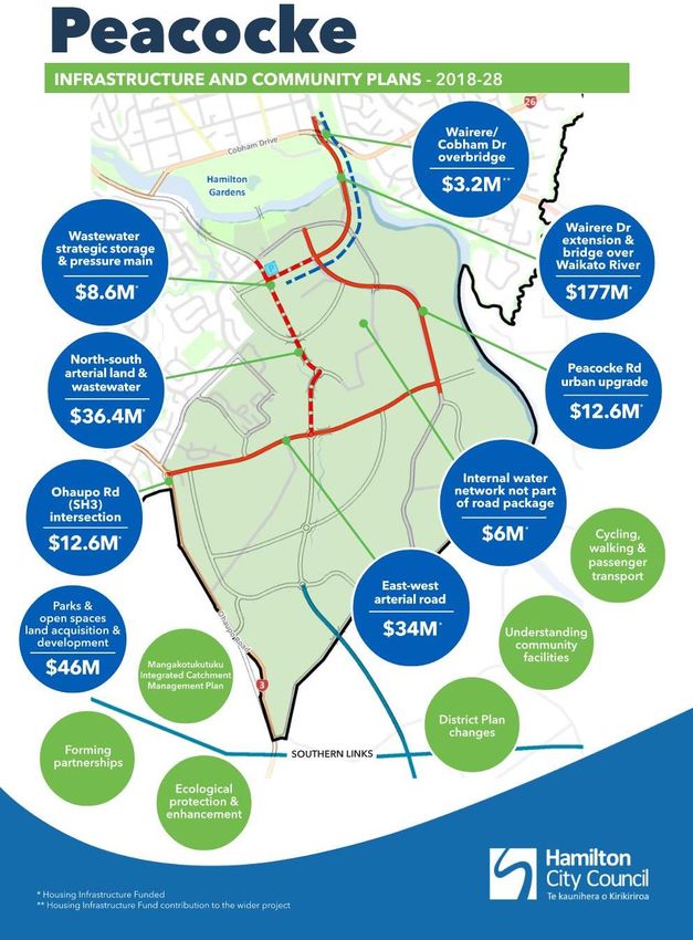
Plan Change 5 Peacocke
                                Integrated Transport Assessment

                                          Hamilton City Council

Prepared by:

               Alastair Black

Approved by:

               Alasdair Gray

ISSUE 1, 3 AUGUST 2021

2 Alfred Street
PO Box 14178
Hamilton, 3214
Tel: 07 853 8997
TABLE OF CONTENTS
1.       Introduction and Purpose ................................................................................................. 1
           Purpose ............................................................................................................................ 1
           Plan Change Overview ..................................................................................................... 1
           Document Structure .......................................................................................................... 1

2.       Background ....................................................................................................................... 2
          Current Structure Plan ...................................................................................................... 2
          Hamilton Southern Links ................................................................................................... 6
          Development Trends and Challenges ............................................................................... 8

3.       Strategic Framework ......................................................................................................... 9
          Summary .......................................................................................................................... 9
          Government Policy Statement on Land Transport 2021-2031 (GPS) .............................. 10
          Vision Zero ..................................................................................................................... 11
          Waka Kotahi Investment Proposal 2021-2031 (WKIP) .................................................... 12
          Waikato Regional Land Transport Plan 2021-2051 ......................................................... 13
          Waka Kotahi Keeping Cities Moving ............................................................................... 16
          Hamilton-Waikato Metro Spatial Plan .............................................................................. 16
          Access Hamilton ............................................................................................................. 17
          Waipa District Council ..................................................................................................... 18
             Summary ..................................................................................................................... 20

4.      The Proposed Structure Plan ......................................................................................... 21
          Integration with Land Use ............................................................................................... 21
          Hierarchy and Layout ...................................................................................................... 21
          Speed Management ....................................................................................................... 22
          Cross-Sections ............................................................................................................... 23
     4.4.1. Arterial Corridors...................................................................................................... 23
     4.4.2. Collector Corridors ................................................................................................... 23
     4.4.3. Local Corridors ........................................................................................................ 24
          Rear Lanes ..................................................................................................................... 25
          Public Transport.............................................................................................................. 26
          Infrastructure and Staging ............................................................................................... 27

5.       Location Specific Assessments ..................................................................................... 29
          North-South Major Arterial .............................................................................................. 29
          Southern Links Modelling ................................................................................................ 29
          Hall Road Upgrade ......................................................................................................... 30

6.       Proposed Objectives and Policies ................................................................................. 31
          ITA Requirements ........................................................................................................... 31
          Active Modes and Universal Access ............................................................................... 31
          Accessible Parking ......................................................................................................... 31

7.       Conclusion....................................................................................................................... 33

Appendix 1: Hall Road Intersection ........................................................................................... 34

Documents/14_275_Peacocke/2021-08-03-PC5-Peacocke-ITA-Issue1.Docx
1. INTRODUCTION AND PURPOSE
     Purpose
Hamilton City Council (HCC) engaged Gray Matter to assess the transport impacts of the proposed
Plan Change for the Peacocke Structure Plan area and to provide technical advice on transport
related issues and provisions. Plan Change 5 (PC5) comprises a review of the current structure
plan and the indicative transport network, increase in development density, a greater focus on mode
shift to non-vehicular modes of transport, public transport and freight, and greater recognition of
ecological and significant natural areas (SNAs).

This Integrated Transport Assessment (ITA) informs the proposed changes to the structure plan. Its
purpose is to:

    =    Review transport policy and objectives in context of the District Plan and local, regional and
         national transport strategies;
    =    Assess the likely transport effects; and
    =    Review the Plan Change rules for practicability and effectiveness.

    Plan Change Overview
The outcome sought by the Peacocke Plan Change is a revised structure plan and district plan
provisions that will assist in creating an attractive and sustainable community in Peacocke.

The project objectives are to

    =    Develop a revised structure plan and planning provisions that deliver on the relevant wider
         programme benefits.
    =    Develop the project outcomes in partnership with internal and external stakeholders and key
         land-owners.
    =    Enhance the environment, specifically in relation to water quality and biodiversity outcomes
         that are consistent with the outcomes sought in the Mangakootukutuku ICMP and the draft
         Biodiversity Strategy.
    =    Increase public transport, cycling and walking modes as set out in Access Hamilton, including
         the ability to assist in achieving the following Access Hamilton KPIs:
             o    20% of all trips are by Public Transport within 10 years.
             o    40% of all short trips (less than 2km) are by walking or cycling.
    =    Develop a land use pattern that provides housing choice while creating accessible new
         community nodes.
    =    Ensure landscape and urban design excellence.

The transport mode shift objectives Access Hamilton are challenging.

    Document Structure
This report includes the following:

    =    Background – a summary of the current structure plan and Hamilton Southern Links.
    =    Strategic framework – national, regional and local policy that impacts the transport network.
    =    Transport issues – a description of current transport issues affecting the Peacocke area.

2021-08-03-Pc5-Peacocke-Ita-Issue1                                                                   1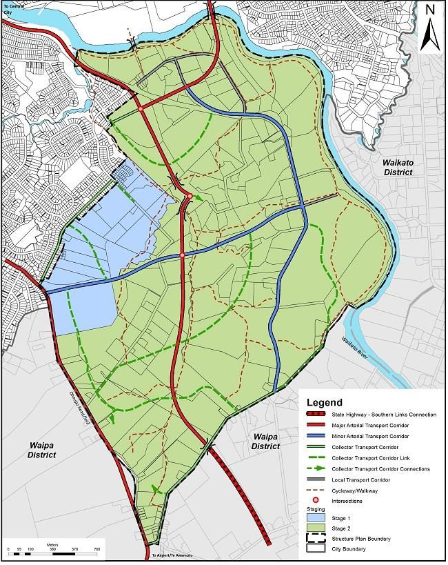
=    Proposal – proposed structure plan details including discussion and assessment of the
         proposed transport network, hierarchy, cross-sections, and timing for construction of the
         strategic transport network.
    =    Specific assessments for the north-south arterial, traffic modelling and the SH3/Hall Road
         intersection.
    =    Proposed objectives and policies
    =    Conclusion and recommendations.

2. BACKGROUND
     Current Structure Plan
The current planned transport network for Peacocke includes a north-south major arterial corridor
and minor arterial corridors in both the north-south and east-west directions. It aims to provide
access to surrounding areas, with connections to the Waikato River for walking and cycling. The
arterial network was determined through the Southern Links project and will not change. Parts of the
transport network are currently being constructed to support growth in Peacocke.

The current transport related objectives specific to Peacocke and the citywide transport objectives
and policies are set out below. They seek to integrate land use and transport through increasing
density around nodes and transport corridors as well as reducing the dependency on the vehicle for
travel. Many of these themes have been reinforced and further developed as part of the plan change.
For example, reducing the dependency on the vehicle and encouraging travel by public transport
has become stronger by prioritising walking, cycling and public transport over the private vehicle.

Table 1 Operative District Plan –Objectives and policies related to Peacocke Structure Plan (left) and Transport (right)

2021-08-03-Pc5-Peacocke-Ita-Issue1                                                                                         2
2021-08-03-Pc5-Peacocke-Ita-Issue1 3
2021-08-03-Pc5-Peacocke-Ita-Issue1 4

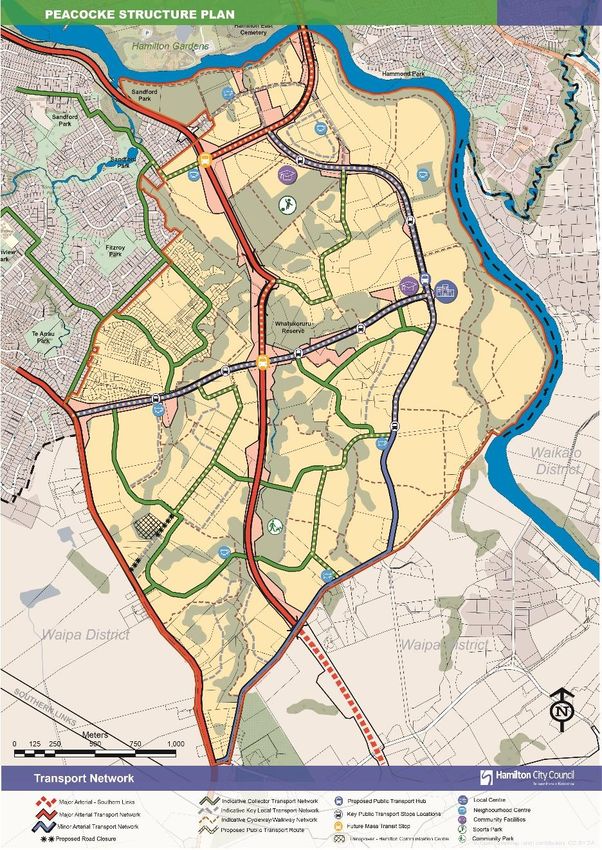
The figure below shows the current structure plan staging and transport network.

                                                           Peacocke Road

                                                   North-south major arterial
    Whatukooruru Drive

                                                   Hall Road

                                                   Peacocke Road

    SH3

                                     Raynes Road

Figure 1:     Current structure plan transport network1 and key features

The key transportation features include2:

      =   Walkway and cycleway route linking all parts of Peacocke to the Central City via the
          Mangakootukutuku Gully and Waikato River corridor. Due to ecological reasons the provision
          of walking and cycling through the Mangakootukutuku Gully has been altered in favour of
          more accessible travel routes along the tops and edges of the gully network.
      =   ‘City Link’ major arterial route which traverses through the central portion of Peacocke and
          links with Cobham Drive at the Cobham Bridge, to provide a direct route to the Central City
          and hospital.
      =   ‘Eastern Link’ major arterial route which branches from the City Link route and crosses the
          Waikato River near Echo Bank Place linking with Cobham Drive and the Hamilton Ring Road,
          thus providing a direct route to the eastern side of the City.

1 https://www.hamilton.govt.nz/our-council/council-
publications/districtplans/ODP/appendix2/Pages/Peacocke-Structure-Plan.aspx
2 https://www.hamilton.govt.nz/our-council/council-publications/districtplans/ODP/chapter3/Pages/3-4-

Peacocke.aspx

2021-08-03-Pc5-Peacocke-Ita-Issue1                                                                      5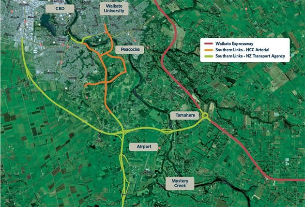
=    ‘City Link’ major arterial route forms part of the ‘Southern Links’ network that will likely connect
         with Kahikatea Drive in the west, and the Waikato Expressway in the east which provides
         strong connectivity in all directions (this link is shown on the figure in the following section).
    =    Minor arterial network that provides a link between the western and eastern sides of the
         growth cell, and the main north-south corridor for the eastern part of the growth cell.
    =    Collector road network that links individual residential neighbourhoods with each other and
         with the arterial roading network.

    Hamilton Southern Links
Southern Links is the state highway and local arterial road network in the southern part of Hamilton.
The detailed objectives are described in the Notice of Requirement. They are summarised as:

    =    Improve transport connections for strategic and economic growth, access to markets,
         transport efficiency and road safety;
    =    Develop and appropriate road hierarchy in the sub-region and recommendations for the
         periphery of the study areas
    =    Improve options for public transport and walking/ cycling
    =    Improve amenity and safety through reduced conflict and crash potential along the existing
         SH1, SH3, SH21 and existing key arterial and collector roads within Hamilton City and key
         local roads.
When completed, the Southern Links network will:

    =    Link SH1 from Kahikatea Drive in Hamilton City to Tamahere and the Waikato Expressway
         in the south;
    =    Link SH3 from Hamilton Airport to central and east Hamilton;
    =    Establish a key transport network within the Peacocke growth cell; and
    =    Provide the building blocks for further urban development in the region.

Delivery of Southern Links will likely be influenced by the Hamilton-Waikato Metro Spatial Plan –
Transport Programme Business Case which is expected to be complete in early/mid-2022.

2021-08-03-Pc5-Peacocke-Ita-Issue1                                                                         6
Figure 2:      Southern Links Network3

Figure 3:      Southern Links Designation and the existing road network in relation to Peacocke.

3   https://www.hamilton.govt.nz/our-city/regional-alliances/southernlinks/Pages/default.aspx

2021-08-03-Pc5-Peacocke-Ita-Issue1                                                                 7
Development Trends and Challenges
HCC’s Access Hamilton Strategy aims to create a more accessible city with mode share for public
transport, walking and cycling increased from 14% to 29% by 2028 and the percentage of short trips
(
3. STRATEGIC FRAMEWORK
     Summary
The Peacocke transport network is supported by a framework of transport related strategies and
policies seeking to meet national, regional and local objectives. This section provides an overview
of relevant strategies and policies, along with a brief summary of how the Peacocke area and Plan
Change objectives is influenced by or can support each policy. We have included:

    =    Government Policy Statement on Land Transport 2021-2031;
    =    Vision Zero;
    =    Waka Kotahi Investment Proposal 2021-2031;
    =    Waikato Regional Land Transport Plan 2021-2031;
    =    Waka Kotahi Keeping Cities Moving;
    =    Hamilton-Waikato Metro Spatial Plan;
    =    Access Hamilton; and
    =    Waipa District Council structure plans.

HCC has other strategies and plans in place for speed management, walking and cycling, and
recently completed a Biking and Micro-mobility Programme Business Case.

The Transportation Network objectives of the Plan Change are set out below. The citywide transport
objectives and policies (provided at Table 1) are applicable but are not changing so are not repeated
here.

Table 2 Proposed Transport Network Objectives
   Reference                                     Objective                                  Relevant Policies
 DEV01-PSP:          An integrated and efficient pattern of land use and transportation   DEV01-PSP: P40
 O17                 so as to sustainably manage the impact of development on             DEV01-PSP: P41
                     existing and planned transport infrastructure.                       DEV01-PSP: P42
                                                                                          DEV01-PSP: P43
 DEV01-PSP:          The transport system in Peacocke provides a high level of            DEV01-PSP: P39
 O18                 connectivity within the structure plan area and to surrounding       DEV01-PSP: P40
                     neighbourhoods.                                                      DEV01-PSP: P42
                                                                                          DEV01-PSP: P43
                                                                                          DEV01-PSP: P49
                                                                                          DEV01-PSP: P51
 DEV01-PSP:          The transport network reduces car dependency and encourages          DEV01-PSP: P39
 O19                 mode shift by:                                                       DEV01-PSP: P40
                        1. Providing a well-connected transport network that              DEV01-PSP: P41
                             prioritises walking and cycling.                             DEV01-PSP: P44
                        2. Designing the transport network to provide safe, direct        DEV01-PSP: P45
                             and universally accessible routes for people walking and
                                                                                          DEV01-PSP: P46
                             cycling throughout the structure plan area.
                                                                                          DEV01-PSP: P47
                        3. Integrating with land use to support the provision of a
                             frequent public transport service.                           DEV01-PSP: P48
                                                                                          DEV01-PSP: P49
                                                                                          DEV01-PSP: P50
                                                                                          DEV01-PSP: P51
                                                                                          DEV01-PSP: P52

2021-08-03-Pc5-Peacocke-Ita-Issue1                                                                         9
Reference Objective Relevant Policies
DEV01-PSP: The transport network is designed to be a high amenity DEV01-PSP: P43
O20 environment that incorporates stormwater management. DEV01-PSP: P53
Government Policy Statement on Land Transport 2021-2031 (GPS)
HCC’s, its neighbours and Waka Kotahi’s objectives are underpinned by the Government Policy
Statement on Land Transport. The GPS has four strategic priorities which are shown below along
with the Transport Outcomes Framework.
Figure 4: Government Policy Statement 2021 (left = strategic priorities; right = Transport Outcomes
Framework)
The transport objectives of the Plan Change are well-aligned with the GPS through the integration
and land use and transport, supporting connectivity, reducing car dependency and encouraging
mode shift. Development of the Peacocke structure plan area provides opportunity to support every
GPS outcome above as discussed below:
Table 3 GPS Outcome and Peacocke support
Proposed Transport
GPS Outcome Opportunity to Support
Objectives, Policy
Inclusive access Providing for and supporting a range of transport modes Objective 25.14.2.1
that meet the needs of everyone. Policy 25.14.2.1a
Requiring specific assessment demonstrating prioritising Policy 25.14.2.1b
walking and cycling, universal access DEV01-PSP: O17
DEV01-PSP: O19
DEV01-PSP: P45
DEV01-PSP: P46
DEV01-PSP: P50
Resilience and Multiple transport links and mode choices, increasing Objective 25.14.2.1
security ability of the network to recover from disruption and Policy 25.14.2.1b
maintain an acceptable operational level of service. DEV01-PSP: O17
DEV01-PSP: P51
2021-08-03-Pc5-Peacocke-Ita-Issue1 10Proposed Transport
GPS Outcome Opportunity to Support
Objectives, Policy
Economic Excellent multi-modal connections to transport nodes and Objective 25.14.2.1
prosperity surrounding areas. Policy 25.14.2.1a
Developing the network to encourage the right traffic on DEV01-PSP: O18
the right routes supporting freight movement on the DEV01-PSP: P40
arterial network
Environmental Minimising effects on significant natural areas, except Objective 25.14.2.1
sustainability where crossed by the transport network. Policy 25.14.2.1c
Supporting the transition to less carbon emissions by DEV01-PSP: O17
providing for and encouraging zero-emission transport DEV01-PSP: P53
modes.
Healthy and safe Providing a safe transport network and supporting healthy Objective 25.14.2.1
people travel choices. Policy 25.14.2.1a
Policy 25.14.2.1b
DEV01-PSP: O19
DEV01-PSP: P47
DEV01-PSP: P52
Vision Zero
The national Road to Zero strategy for 2020-2030 outlines a plan to stop people being killed or
injured on our roads It is based on the Vision Zero approach and supporting the GPS outcome
seeking healthy and safe people.
As a city, Hamilton has a Vision Zero aspiration for road safety – “This means we will not accept the
death of any person on our transport system. We will design and deliver infrastructure that
recognises humans are fallible and that when we make a mistake, we should not pay for it with our
life”4.
In accordance with Vision Zero principles and recognising that a safe transport system is vital to the
success of the Peacocke Structure Plan area and the wider city, streets will be designed to protect
pedestrians, cyclists and other vulnerable road users, and prevent death and serious injuries for all
road users. This will lead to a more vibrant, healthy urban environment.
One of the main differences between the traditional approach to transport design and the Vision Zero
approach is the reduced tolerance for death and serious injury resulting from the operation of the
transport network. One of the main methods for achieving this is by designing roads so motorists will
drive more slowly, i.e. survivable speeds. Some of the tools for achieving this include:
= Providing narrow carriageways.
= Providing narrow intersections: allow larger vehicles to use the whole intersection and cross
the centreline or centre of the carriageway.
= Limiting forward visibility, through geometry and/or planting.
= Increasing side friction, through planted berms, kerb buildouts etc.
= Using vertical deflection (raised crossings and raised tables).
4Refer to Hamilton City Council Website: https://www.hamilton.govt.nz/our-
services/transport/accesshamilton/Pages/default.aspx
2021-08-03-Pc5-Peacocke-Ita-Issue1 11Changes to the Peacocke Structure Plan better support Vision Zero through Objective O18 which
states “Designing the transport network to provide safe, direct and universally accessible routes …”
and prioritise walking, cycling and public transport over the private vehicle (refer to Objectives O18,
O19 and Policies P49, P50).
Development of an integrated walking and cycling network will separate vulnerable road users from
vehicles on collector roads (e.g. Policy P52) making these modes safer and more attractive to
support mode shift.
The proposed changes to the Structure Plan provide guidance on design speed, width of the
carriageway and footpaths and introduce requirements separated cycleways on the collector
network, guidance on the design of rear lanes and how the interact with the public transport network.
Specific design of features such as intersections and pedestrian facilities will need to be considered
during detailed design of individual developments.
Waka Kotahi Investment Proposal 2021-2031 (WKIP)
The Waka Kotahi Investment Proposal5 sets out the programme of activities that they propose for
inclusion in the National Land Transport Plan (NLTP). Waka Kotahi uses Arataki: our plan for the
land transport system 2021–31, their 10-year view of what is needed across New Zealand’s land
transport system, to deliver the GPS priorities and the government’s longer-term outcomes. It is
framed by five step changes where there is a need for change. The step changes and how they
relate to the Peacocke Structure Plan are outlined below:
Table 4 Waka Kotahi step changes / drivers, and Peacocke support
Waikato Proposed Transport
Opportunity to Support
Context Objectives, Policy
Improving Building a safe transport network that is integrated with land Objective 25.14.2.1
safety use and deliver safe travel speeds Policy 25.14.2.1a
Policy 25.14.2.1b
DEV01-PSP: O17
DEV01-PSP: O19
DEV01-PSP: P47
DEV01-PSP: P52
Better travel Prioritises walking, cycling and PT by providing higher density Objective 25.14.2.1
options around key transport corridors and activity centres. Policy 25.14.2.1b
Develops a well-connected network that is continuous and safe DEV01-PSP: O17
Design infrastructure that makes walking and cycling safe and DEV01-PSP: O18
attractive DEV01-PSP: O19
Work together to develop travel options for the north-south DEV01-PSP: P41
arterial through the Metro Spatial Plan and Keeping Cities
DEV01-PSP: P45
Moving
DEV01-PSP: P46
DEV01-PSP: P48
DEV01-PSP: P50
Better freight Provides efficient connections with the wider network through Objective 25.14.2.1
connections the Southern Links network. Policy 25.14.2.1a
Develops the network to encourage the right traffic on the right Policy 25.14.2.1b
routes, i.e. supporting freight movement on the arterial network DEV01-PSP: O18
DEV01-PSP: P40
5 https://www.nzta.govt.nz/planning-and-investment/national-land-transport-programme/waka-kotahi-
investment-proposal-2021-31/
2021-08-03-Pc5-Peacocke-Ita-Issue1 12Waikato Proposed Transport
Opportunity to Support
Context Objectives, Policy
Climate Supporting and encouraging environmentally friendly modes, Objective 25.14.2.1
change protecting significant natural areas, reducing emissions by Policy 25.14.2.1b
optimising transport and supporting low-emission travel Policy 25.14.2.1c
options.
DEV01-PSP: O19
DEV01-PSP: P50
Working Implement a walking and cycling networks that link to the Objective 25.14.2.1
together existing networks Policy 25.14.2.1a
Work together through the Metro Spatial Plan to deliver DEV01-PSP: O17
infrastructure to support mode shift and development of
Peacocke and Southern Links networks
The Peacocke Plan Change is well-aligned with the step-changes and drivers of the WKIP through
a focus on integrating land use and transport to drive mode shift. However, only two projects related
to Peacocke are included in the WKIP:
= Waka Kotahi’s part of Hamilton Southern Links
o Identified as contributing to the GPS priority of “Better Travel Options”. The focus of
this priority is to provide people with better travel options to access places for earning,
learning and participating in society, measured through use of public transport,
walking and cycling along with environmental indicators;
o Investigation proposed for 2021-24; and
o Property purchase proposed for 2021-24, 2024-27 and 2027-31.
= SH3/ Raynes Road intersection
o Identified as contributing to the GPS priority of “Improving Safety”. The focus of this
priority is to develop a transport system where no-one is killed or seriously injured,
measured by the number of deaths and serious injuries on our roads; and
o Implementation proposed for 2021-24.
Waikato Regional Land Transport Plan 2021-2051
The Waikato Regional Land Transport Plan (WRLTP) 2021-2051 outlines the strategic direction for
land transport in the Waikato Region. It describes what the region is aiming to achieve for the land
transport system in the context of a growing Hamilton-Waikato metro-spatial area. The Regional
Transport Committee endorsed the WRLTP in June 2021.
The Plan Change is well-aligned with the WRLTP as discussed in the following table.
Table 5 WRLTP Objectives and Peacocke support
Proposed Transport
WRLTP Objectives Peacocke Response
Objectives, Policy
An efficient and resilient land Peacocke is consistent with Southern Objective 25.14.2.1
transport system that advances Links and provides an arterial network Policy 25.14.2.1a
regional economic wellbeing, and that provides for the movement of people DEV01-PSP: O17
facilitates the movement of people and freight.
DEV01-PSP: O18
and freight on strategic corridors
in the upper North Island.
2021-08-03-Pc5-Peacocke-Ita-Issue1 13Proposed Transport
WRLTP Objectives Peacocke Response
Objectives, Policy
A planned transport response that Peacocke is consistent with Southern Objective 25.14.2.1
supports liveable urban areas and Links and planned urban development Policy 25.14.2.1a
future growth areas. Prioritises walking, cycling and PT by Policy 25.14.2.1b
providing higher density around key DEV01-PSP: O17
transport corridors and activity centres.
DEV01-PSP: O18
Design focus on providing low speed
DEV01-PSP: O19
urban environments.
DEV01-PSP: P44
DEV01-PSP: P46
A safe, accessible transport Design focus that prioritises walking, Objective 25.14.2.1
system in the Waikato region, cycling and PT in a low speed urban Policy 25.14.2.1a
where no one is killed or seriously environment. DEV01-PSP: O19
injured.
DEV01-PSP: P47
DEV01-PSP: P52
A transport system that provides Prioritises walking, cycling and PT by Objective 25.14.2.1
an inclusive range of integrated, providing higher density around key Policy 25.14.2.1a
safe, accessible, quality travel transport corridors and activity centres. Policy 25.14.2.1b
choices for people to meet their
DEV01-PSP: O17
social, economic and cultural
needs. DEV01-PSP: O19
DEV01-PSP: P41
DEV01-PSP: P45
DEV01-PSP: P46
DEV01-PSP: P48
DEV01-PSP: P49
DEV01-PSP: P50
An environmentally sustainable, Supporting and encouraging Objective 25.14.2.1
energy efficient and low-carbon environmentally friendly modes. Policy 25.14.2.1c
transport system that delivers Integrating with significant natural areas to DEV01-PSP: O19
emissions reductions and protect their core functions DEV01-PSP: P44
enhances communities’ long-term Reducing emissions by optimising
resilience to the effects of climate DEV01-PSP: P50
transport and supporting low-emission
change. travel options.
Collaboration around spatial and Prioritises walking, cycling and PT by Objective 25.14.2.1
place-based planning results in a providing higher density around key Policy 25.14.2.1a
safe and efficient transport system transport corridors and activity centres. DEV01-PSP: O17
that supports thriving and healthy Consistent with the Southern Links DEV01-PSP: O18
urban and rural communities and designation which means its consistent
economic wellbeing. with regional objectives
2021-08-03-Pc5-Peacocke-Ita-Issue1 14Table 6 WRLTP Policies relevant to Peacocke
Proposed Transport
WRLTP Objectives Peacocke Response
Objectives, Policy
Develop multi-modal transport solutions Peacocke is consistent with Objective 25.14.2.1
that support agreed national, regional Southern Links and provides an Policy 25.14.2.1a
and spatial planning outcomes for arterial and local transport networks Policy 25.14.2.1b
housing and growth. that support planned urban
DEV01-PSP: O17
development.
DEV01-PSP: O18
DEV01-PSP: P44
DEV01-PSP: P45
DEV01-PSP: P46
DEV01-PSP: P47
Support key urban development projects Consistent with development of Objective 25.14.2.1
that support Hamilton-Waikato metro infrastructure within Peacocke. Policy 25.14.2.1a
spatial outcomes. Southern Links to be considered in DEV01-PSP: O18
Hamilton-Waikato Metro Spatial DEV01-PSP: P39
Plan Transport Programme
DEV01-PSP: P40
Business Case.
DEV01-PSP: P51
Provide an inclusive transport system, Prioritises walking, cycling and PT Objective 25.14.2.1
including: by providing higher density around Policy 25.14.2.1b
= public transport in and between key transport corridors and activity DEV01-PSP: O17
centres. centres.
DEV01-PSP: O18
Engagement with WRC has
= rapid and high frequency public DEV01-PSP: O19
identified PT corridors and locations
transport on core corridors in DEV01-PSP: P41
for proposed PT hubs and bus
greater Hamilton. stops on minor arterials DEV01-PSP: P42
= passenger rail between Hamilton DEV01-PSP: P44
and Auckland. DEV01-PSP: P45
= alternative delivery modes to DEV01-PSP: P46
improve rural access. DEV01-PSP: P48
= safe and accessible walking and DEV01-PSP: P50
cycling networks. DEV01-PSP: P52
Promote initiatives that support travel Prioritises walking, cycling and PT Policy 25.14.2.1a
behaviour change, mode shift and by providing higher density around DEV01-PSP: O17
compact urban form. key transport corridors and activity DEV01-PSP: O19
centres.
DEV01-PSP: P41
Defines the PT network
DEV01-PSP: P42
Directs development of continuous
DEV01-PSP: P44
and safe walking and cycling
network DEV01-PSP: P48
DEV01-PSP: P49
Look for funding opportunities to - -
advance access and mobility outcomes.
Uptake new technology to enhance Detailed design can implement Policy 25.14.2.1b
transport outcomes. measures such as PT priority at
intersections
Encouraging urban form that supports Urban form locates density around DEV01-PSP: O17
low carbon and low emission transport collector corridors and activity DEV01-PSP: P39
options. centre to prioritise movement by DEV01-PSP: P40
walking, cycling and PT.
DEV01-PSP: P41
2021-08-03-Pc5-Peacocke-Ita-Issue1 15Waka Kotahi Keeping Cities Moving
“Keeping Cities Moving” is Waka Kotahi’s plan for mode shift. The objective is to grow the share of
travel by public transport, walking and cycling in order to help cities thrive. The transport network
needs to provide mode choices and help people move around easily.
Waka Kotahi’s plan (page 6) looks to support thriving urban areas in three ways:
= shaping urban form;
= making shared and active modes more attractive; and
= influencing travel demand and transport choices.
The Peacocke Structure Plan provides opportunities to implement all three of the above methods to
support a thriving urban area. The transport objectives of the Plan Change (i.e. O17, O18 and O19)
are well-aligned with Keeping Cities Moving as they seek an integrated and efficient pattern of land
use and transport, providing a high level of connectivity and reducing car dependence and
encouraging mode shift.
The area specific plan for the Waikato (Hamilton-Waikato Regional Mode-shift Plan) lists Peacocke
as a key area for the transport intervention “place shaping”, or “ensuring layout and design of new
urban areas supports the use of public transport, walking and cycling”. As examples, the transport
policies of the Plan Change direct:
= connectivity and integration of transport and land use (P39 and P40);
= development of walkable neighbourhoods (P45);
= delivery of high quality and accessible PT (P42 and P46);
= a continuous and safe walking and cycling network (P45 and P49); and
= prioritises pedestrians and cyclists over vehicles (P50).
Hamilton-Waikato Metro Spatial Plan
The Hamilton-Waikato Metro Spatial Plan6 has the vision for the Hamilton-Waikato metro area as “a
place where our people can easily access employment, education and health facilities, serviced by
reliable and efficient transport connections and great places.” The plan’s vision is supported by six
transformational moves. These are listed below, along with the relevance of the Peacocke area.
Table 7 Metro Spatial plan
Proposed Transport
Transformational Move Peacocke support
Objectives, Policy
Waikato River: celebrating the Waikato River as Multiple connections to the DEV01-PSP: O18
the defining ecological feature connecting the river and gully network for DEV01-PSP: O20
metro area to the heart of a blue-green network walking and cycling (although DEV01-PSP: P53
supporting environmental and recreational use access to gully network is
and creating a sense of place. limited for ecological reasons).
Stormwater devices integrated
into a green network with
pedestrian access
6 https://futureproof.org.nz/h2a/metrospatialplan/
2021-08-03-Pc5-Peacocke-Ita-Issue1 16Proposed Transport
Transformational Move Peacocke support
Objectives, Policy
A radical transport shift: a multimodal Provides a multi-modal Objective 25.14.2.1
transport network, connecting the metro area network, that prioritises public Policy 25.14.2.1a
and facilitating a radical shift to using public transport services and Policy 25.14.2.1b
transport through the establishment of a rapid separates cyclists from
DEV01-PSP: O17
and frequent public transport network shaped vehicles.
around where and how our communities will DEV01-PSP: O18
Higher development density
grow. supports use of alternative DEV01-PSP: P44
modes DEV01-PSP: P49
DEV01-PSP: P50
DEV01-PSP: P52
A vibrant metro core and lively metropolitan Reliable links to Hamilton city Objective 25.14.2.1
centres: growing Hamilton central city as our centre and the local centre Policy 25.14.2.1a
civic, administrative, cultural and commercial within Peacocke. DEV01-PSP: O17
metro core, alongside lively metropolitan Arterial connections provide for DEV01-PSP: O18
centres, well connected by public transport and vehicle connectivity with strong
safe walking and cycling networks, where people DEV01-PSP: O19
walking and cycling links
can afford to live, work and play. provided DEV01-PSP: P39
DEV01-PSP: P40
DEV01-PSP: P41
A strong and productive economic corridor: Peacocke arterial network Objective 25.14.2.1
establishing an economic corridor that links the connected to city wide and Policy 25.14.2.1a
highly productive employment areas between planned regional network DEV01-PSP: O18
Ruakura, Hamilton central city and north to supporting economic and
DEV01-PSP: P40
Horotiu. movement functions.
Iwi aspirations: enhancing the environmental Protection of significant natural DEV01-PSP: O18
health and wellbeing of the Waikato River in areas. DEV01-PSP: O20
accordance with the Te Ture Whaimana o Te DEV01-PSP: P53
Awa o Waikato – Vision and Strategy for the
Waikato River, while supporting iwi in embracing
social and economic opportunities within the
metro area with a specific emphasis on
Hopuhopu and Ruakura.
Thriving communities and Efficient land use and transport Objective 25.14.2.1
neighbourhoods: enabling quality denser network planning and DEV01-PSP: O17
housing options that allow our natural and built integration. DEV01-PSP: O19
environments to coexist in harmony increasing
housing affordability and choice to meet the
needs of growing and changing communities.
Access Hamilton
Access Hamilton7 was first developed in 2010 and was refreshed in 2018 to ensure the city can
respond to higher than expected growth in the best way possible to achieve the following outcomes
areas:
7 https://www.hamilton.govt.nz/our-services/transport/accesshamilton/Pages/default.aspx
2021-08-03-Pc5-Peacocke-Ita-Issue1 17Figure 5: Access Hamilton Transport Outcome Areas Access Hamilton identifies investment opportunities in transport activities across a range of modes. It has a strong focus on improving accessibility for pedestrians and cyclists and public transport users and supporting new growth areas. Investment in the transport system aims to deliver a reduction in serious injuries by 30% by 2028 and 60% by 2048, with an overarching goal of zero deaths. It also aims to create a more accessible city with mode share for public transport, walking and cycling increased from 14% to 29% by 2028 and the percentage of short trips (
Houchens Road
                                                           intersection with SH3

                                                               Indicative future
                                                               roading link

Figure 6: Houchens Road Structure Plan (Waipa District Plan, Appendix S13 -Houchens Road
   Structure Plan)

While the structure plan shows an indicative roading link to SH3, the assessment was based on an
upgrade of the SH3/Houchens Road intersection and did not require a second access to SH3. This
is reflected in the Waipa District Plan8 which only describes mitigation at the SH3/ Houchens Road
intersection. This intersection may only be practicable after constructing sufficient stages of Southern
Links that allows revocation of state highway status from SH3/ Ohaupo Road.

8   Waipa District Plan, Rules 15.4.2.70 – 15.4.2.81

2021-08-03-Pc5-Peacocke-Ita-Issue1                                                                   19
Figure 7: Airport (Waipa District Plan, Appendix S1 – Future Growth Cells)
Summary
In summary, the Plan Change is well aligned with the national, regional and local strategic transport
frameworks. These frameworks seek improvement access for all users, provide safe transport
networks, provide for economic growth and environmental sustainability/ climate change.
The current transport provisions of the District Plan support the strategic framework, but the
Peacocke Plan Change seeks to go further through the objectives and policy seeking integration of
land use and transport with a focus on higher density development near key transport corridors and
activities nodes along with prioritising pedestrians and cyclists over vehicles. The policy framework
providing supporting detail including requirements for the transport network to provide for public
transport services and infrastructure, separation of cyclists from vehicles on the collector network
and providing a continuous and safe walking and cycling network.
2021-08-03-Pc5-Peacocke-Ita-Issue1 204. THE PROPOSED STRUCTURE PLAN
Integration with Land Use
The vision for the Peacocke area is that it will become a high-quality urban environment that is based
on urban design best practice, social well-being, and environmental responsibility. It is important
land development in the Peacocke area occurs in such a way that it takes advantage of its location,
responds to and respects the important ecological values of the area and integrates with the
transport network to ensure a high level of accessibility is maintained into and throughout the area.
The success of Hamilton's transport system relies on creating a new approach for multi-modal
(different types of transport) movement. The Peacocke area will be developed in line with Hamilton’s
vision set out in Access Hamilton and consistent with Vision Zero. In a transport sense this means
developing an integrated transport system that supports the proposed land use, comprising a multi-
modal transport network that provides access to frequent public transport on key routes and a direct
and accessible walking and cycling network, that is safe and enjoyable to use. The network will be
constructed to meet best practice principles related to safety, coherence, directness, attractiveness
and amenity which will assist in encouraging mode shift, in particular for shorter trips of less than
2km.
Key transport features that distinguish Peacocke from the current District Plan provisions are:
= Wider footpaths on local corridors;
= Provided separated cycle lanes on the collector network;
= Identification of public transport routes so that infrastructure can be provided at the time of
subdivision;
= Bus stops are to be provided in-lane to minimise delays to the public transport services;
= Provide for increased use of rear lanes for property access; and
= Provide for higher density along identified public transport corridors and around the local
centre and other areas of activity/amenity to support public transport services.
The Transportation Network objectives of the Plan Change are set out in Section 3.1 above. DEV01-
PSP-O17 specifically addresses integration with the objective of “An integrated and efficient pattern
of land use and transportation so as to sustainably manage the impact of development on existing
and planned transport infrastructure.”
Hierarchy and Layout
The key transport features of the proposed structure plan are well aligned with the current structure
plan. The proposed transport network includes:
= Major and minor arterial networks that align with the current structure plan and Hamilton
Southern Links;
= Extending the minor arterial south of the Peacocke Local Centre through to the Peacocke
Road/ Raynes Road intersection;
= Revisions to alignment and location of the collector network; and
= More direction on public transport routes and locations for bus stops on the minor arterial
network.
2021-08-03-Pc5-Peacocke-Ita-Issue1 21Figure 8: Proposed Structure Plan
Speed Management
The principles of the HCC Speed Management Plan seek that:
= Where there are high numbers of people walking, biking and crossing the road the speed
environment will be 30km/h;
= Residential local roads will be constructed for a 40km/h environment; and
= New roads will be constructed appropriate to the function and to create a safe and appropriate
environment.
The proposed design speed environments are 30km/h on local residential corridors and 40km/h on
the collector network. Peacocke has a lower design speed environment than other local roads to
support mode shift and contribute to Vision Zero. These design speed environments are support by
the cross-sections developed for Peacocke. The proposed structure plan is consistent with the
principles of the HCC Speed Management Plan.
2021-08-03-Pc5-Peacocke-Ita-Issue1 22Cross-Sections 4.4.1. Arterial Corridors The major and minor arterial corridors within the structure plan area were designated through the Hamilton Southern Links project, except for the proposed extension south of the Peacocke local centre. The design and construction of arterial corridors is led by HCC, and it is not necessary for details to be provided in this Structure Plan. SH3 is a major arterial in the HCC transport corridor hierarchy and identified as a Regional Strategic corridor in the One Network Road Classification. The form and function of this corridor will likely be reviewed following construction of Southern Links. 4.4.2. Collector Corridors Collector corridors perform both a movement and property access function. Collector corridors connect local neighbourhoods and provides connections to the wider arterial network. Cycling and walking facilities within the collector corridor should be separated to ensure a safe and efficient pedestrian and cycling network that promotes active modes of transport. Property access is not restricted but will need to specifically consider inclusion of the separated cycle facilities to minimise disruption of cycle travel and improve road safety. The proposed cross-sections depart from the District Plan standards (Appendix 15, Table 15-6a)ii)) due to the introduction of separated cycle lanes. The District Plan anticipate 1.5m wide on-road cycling, but the Structure Plan requires a 2m cycle lane with 0.6m buffer (2.7m total width) to the parking/ berm. The Structure Plan specifically identifies the public transport corridors on some collector corridors as they require slightly wider movement lanes (3.4m). On other collectors 3.2m wide lanes are adequate. The proposed cross-sections are shown below, noting that the 2.5m wide berm/ parking lane/ bus shelter will likely alternate along the road so that parking is provided on both sides. Figure 9: Proposed Collector Cross-Section 2021-08-03-Pc5-Peacocke-Ita-Issue1 23
Figure 10: Proposed Collector Cross-Section for Identified PT Routes

4.4.3. Local Corridors
The principal transport function of local corridors is to provide property access, with low traffic
volumes and low vehicle speeds. Walking and cycling are prioritised as the fundamental units of
movement, with through traffic discouraged. Movements by heavy vehicles are expected to by
emergency vehicles, rubbish and refuse collection trucks and deliveries/ moving trucks, so the local
corridors need to adequately provide for manoeuvering of these large vehicles. These local corridors
also have an important function in enhancing the urban environment by providing amenity through
landscaping and street trees, stormwater management and providing space for other infrastructure.

The District Plan (Appendix 15, Table 15-6a)ii)) currently provides for two different local corridor
cross-sections, 16m where there are 10-20 lots and 20m where there are more than 20 lots. This
Structure Plan simplifies this by providing a single cross-section standard to support transport
functions. It acknowledges additional width may be required to provide for stormwater management
and landscaping. The Plan Change supports the use of rear lanes which reduces the need for two
local corridors standards. This simplification is supported by new subdivision standards that control
block length and depth which support development of more walkable neighbourhoods. For example,
the rules9 limit block length to 250m and block perimeter to 750m.

The proposed 16.8m width of local transport corridors within Peacocke departs from the District Plan
standard for low volume local corridors by:

=     Providing wider footpaths to support active modes. 1.8m width footpaths are required compared
      to the District Plan standard of 1.5m; and
=     Increasing the berm width from 2.0m to 2.1m to better accommodate parked cars.

9   Rule SUB-PREC1-PSP: R18 Block Structure and roading

2021-08-03-Pc5-Peacocke-Ita-Issue1                                                                24
Figure 11: Proposed Local Corridor Cross-Section
Rear Lanes
The Structure Plan promotes the use of rear lanes to provide an alternative for vehicle access to
properties which minimises the number of vehicles crossings along pedestrian and cycling routes.
This has significant benefits for pedestrians and cyclists by reducing the number of potential conflict
points, this is especially important on collector corridors where separated cycle lanes are provided.
The Structure Plan adopts the District Plan standard for design of rear lanes and specifies a minimum
width of 7m10. The subdivision rules11 limit the maximum number of residential units served by a rear
lane to 20 units.
In an ideal Vision Zero environment vehicle crossings across the separated cycle lane would be
avoided. Design of the arterial network avoids direct property access where traffic volumes and
speeds will be higher. However, this is not practicable for the collector network where a degree of
property access is required. It is proposed to minimise the number of vehicle crossings through the
separated cycle lanes through the proposed provisions12 which requires that “In the Peacocke
Structure Plan area, on collector roads where a shared path or separated cycleway are provided,
there shall be a minimum distance of 50m between vehicle crossings.”
Where vehicle crossings are provided there are a number of ways to design the interface to
prioritising pedestrians and cyclists over manoeuvering vehicles. The proposed assessment criteria13
require that these crossings are “designed to maximise the safety of pedestrians and cyclists”. The
NACTO Urban Bikeway Design Guide provides the following guidance.
10 Rule 25.14.4.1h)vii)
11
SUB-PREC1-PSP: R20 Provision of parking and access
12 Rule 25.14.4.1a)v)
13 Rule 1.33 P5 l) Subdivision in the Peacocke Structure Plan
2021-08-03-Pc5-Peacocke-Ita-Issue1 25Figure 12: Guidance on Cycle Lane/ Vehicle Crossing Interface14
Public Transport
Public transport routes have been identified within the structure plan based on the development of a
public transport network by Waikato Regional Council (WRC). These routes will be supported by
enabling higher density development on these corridors, which will support the creation of a viable,
frequent public transport service.
Engagement with Waikato Regional Council included discussion on:
= Cross-sections for collector corridors;
= Location for proposed public transport hubs and bus stops on minor arterials;
= Routes for key/ frequent services; and
= Routes for local services.
The proposed public transport network is shown below.
14 https://nacto.org/publication/urban-bikeway-design-guide/
2021-08-03-Pc5-Peacocke-Ita-Issue1 26Figure 13: Public Transport Corridors The introduction of separated cycle lanes and in-lane bus stops means it is challenging to retro-fit bus stop infrastructure, so it needs to be provided at the time of subdivision. It is proposed to identify the proposed collector road for public transport services within the District Plan to recognise that these corridors require a slightly wider movement space and specific design and construction of bus stop infrastructure at the time of subdivision. The proposed policy and rule framework (SUB-PREC1-PSP: P8, P9 and P16, SUB-PREC1-PSP: R25) directing the provision of public transport infrastructure are supported by existing and proposed assessment criteria (for example criteria G1e) and P5m)). Infrastructure and Staging HCC is currently delivering much of the strategic transport infrastructure necessary to support the Peacocke Structure Plan through funding received from the Government’s Housing Infrastructure Fund. Delivery of the north-south major arterial network is not funded in the 2021-2031 LTP. The Plan Change provides a staging programme to ensure that urbanisation does not occur out of sequence with the delivery of key strategic infrastructure. 2021-08-03-Pc5-Peacocke-Ita-Issue1 27
This excludes delivery of the north-south arterial will be influenced by the Hamilton-Waikato Metro
Spatial Plan – Transport Programme Business Case (PBC) which is expected to be complete in
early/mid-2022.

Figure 14: 2018-2028 Peacocke Delivery15

15   https://www.hamilton.govt.nz/our-city/city-development/peacocke/upcoming-works/Pages/default.aspx

2021-08-03-Pc5-Peacocke-Ita-Issue1                                                                       28
5. LOCATION SPECIFIC ASSESSMENTS
    North-South Major Arterial
The Southern Links north-south major arterial corridor was designated with width to support a four-
lane road corridor. Currently there is no funding for construction of this corridor within HCC’s LTP.

Through the current Peacocke Strategic Transport project HCC is working is establish a walking and
cycling route along the designation. This will support HCC’s objectives for mode shift by creating a
dedicated walking and cycling corridor that provides a direct route from the centre of the structure
plan area to the north. Waka Kotahi have indicated that financial assistance is unlikely. HCC have
indicated that it is unlikely to be an investment priority for the Biking and Micro-mobility Programme.
A walking and cycling connection may therefore not be realised before the north-south arterial is
construction (more than 10 years away).

The long-term allocation of space in this corridor will be influenced by the Hamilton-Waikato
Metropolitan Spatial Plan – Transport Programme Business Case which is due for completion in
early/mid-2022. In the medium/ long-term, the priority is likely to shift towards providing for walking,
cycling and public transport. For example, the four lanes could be allocated as two for public transport
and two for general traffic.

The current structure plan indicates collector intersections with the north-south major arterial. The
location of these connections has changed as a result of changes in the network layout. These
interactions are not shown on the Southern Links designation. The form of any connection has not
been determined and a wide range of options exist from full access (e.g. a roundabout) through to
limited access via left-in/left-out arrangement, only providing access for walking and cycling, or no
access.

The Structure Plan continues to provide for this major arterial transport corridor without constraining
future decisions on the form or allocation of space.

     Southern Links Modelling
Development of this plan change has not included traffic modelling. Carrying out modelling of the
network was not considered necessary as the arterial network was extensively modelled during
investigation and designation of the Southern Links network. This modelling was based on a 2041
land use with 8,028 households and a population of 22,07716. It confirmed the location and form of
the transport network as well as testing intersections on the arterial network.

Council’s Detailed Business Case17 supporting the application to the Housing Infrastructure Fund
anticipated development of 8,400 homes over the next 30 years. This is approximately 5% more
dwellings than modelled in the Southern Links investigation. More recently modelling has been
completed to support implementation of strategic transport infrastructure for Peacocke and to refine
design of the network and arterial intersections.

Due to changes in how the structure plan responses to issues related to ecology, significant natural
areas (SNA) and stormwater requirements, the Plan Change anticipates that Peacocke will
accommodate between 7,500 and 8,000 new homes. This is consistent with the Southern Links
modelling. The reduction in developable area means that net density within Peacocke targets 20-50
dwellings per hectare, with higher density concentrated around nodes and public transport corridors.

16   Southern Links Scheme Assessment, Appendix E: Transport
17   Hamilton – Peacocke Detailed Business Case, Housing Infrastructure Fund, November 2017

2021-08-03-Pc5-Peacocke-Ita-Issue1                                                                   29
In summary, the expected population in Peacocke remains generally consistent with the earlier
Southern Links modelling. The transport focus of the plan change is on integration of land use and
transport to achieve mode shift to walking, cycling and public transport. This should mean that
vehicular demand from the Structure Plan area is similar or less than originally planned for.
Hall Road Upgrade
Hall Road is currently a local no-exit road that forms a T-intersection with Ohaupo Road (SH3). The
current traffic volume is approximately 300veh/day with 15,300veh/day and 11% on Ohaupo Road.
SH3 is a Limited Access Road18, meaning that any vehicle crossings or intersections to SH3 need
to be authorised by Waka Kotahi.
The current District Plan shows Hall Road as a local corridor. The current structure plan identifies it
as a collector with no direct connection to SH3, but connections to Whatukooruru Drive through
Stage 1B, and to and across the north-south arterial.
Within an increase in traffic from development on Hall Road, there is a significant risk of an increase
in crashes and delays at the intersection. Due to the topography, there are no practicable options to
safety provide for more intensive use of the intersection. Therefore, development on Hall Road will
need to either be delayed until other internal connections are provided, or alternative access is
provided. For example, a left-in/left-out arrangement may be acceptable when a roundabout is in
place at the SH3/ Raynes Road intersection.
The proposed infrastructure staging sets out that the Hall Road upgrade needs to be dealt with as
part of developing Stages D, E and H. HCC does not deliver the collector network and the developer
of these stages will need to investigate options and deliver the infrastructure are part of their
development.
18 https://maphub.nzta.govt.nz/public/?appid=d4ae73824516451cbc9000850a9a1919
2021-08-03-Pc5-Peacocke-Ita-Issue1 30You can also read