REVIEW OF POTENTIAL STRATEGIC SITES FOR BRIDGNORTH - Shropshire Council Strategic Review
←
→
Page content transcription
If your browser does not render page correctly, please read the page content below
Shropshire Council

REVIEW OF POTENTIAL
STRATEGIC SITES FOR
BRIDGNORTH
Strategic Review

APRIL 2021            INTERNAL
Shropshire Council

REVIEW OF POTENTIAL STRATEGIC SITES
FOR BRIDGNORTH
Strategic Review

TYPE OF DOCUMENT (VERSION) INTERNAL

PROJECT NO. 70077973

DATE: APRIL 2021

                                      INTERNAL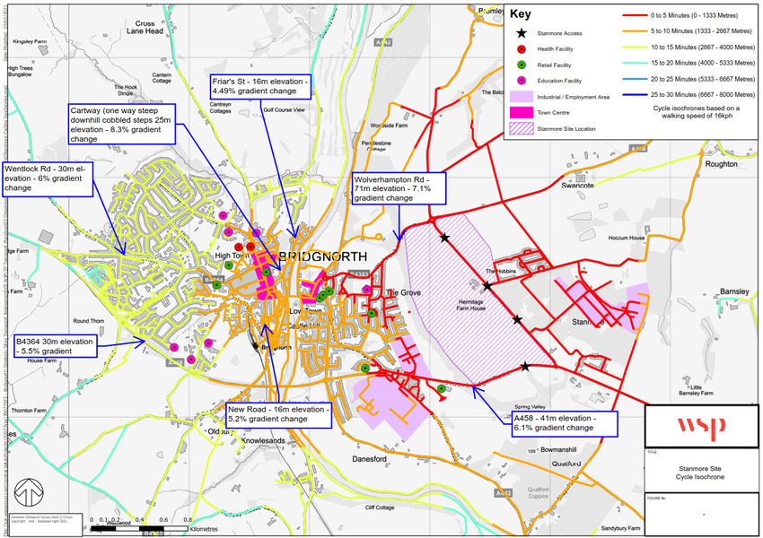
Shropshire Council

REVIEW OF POTENTIAL STRATEGIC SITES
FOR BRIDGNORTH
Strategic Review

WSP
2 London Square
Cross Lanes
Guildford, Surrey
GU1 1UN
Phone: +44 148 352 8400

WSP.com

                                 INTERNAL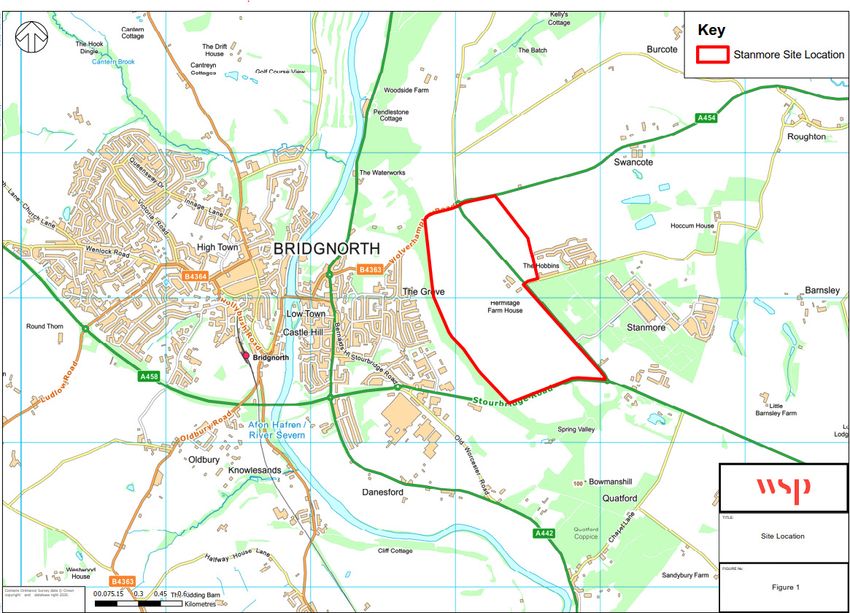
QUALITY CONTROL

Issue/revision    First issue     Revision 2         Revision 3   Revision 4

Remarks           Draft           Version 2

Date              February 2021   April 2021

Revision          v1d             v2b

Prepared by       ST              ST

Checked by        TP              MJP

Signature

Authorised by     TP              TP

Signature

Project number    70077973        70077973

Report number     01              01

File reference    70077973-01vd   70077973-02vb

REVIEW OF POTENTIAL STRATEGIC SITES FOR BRIDGNORTH                INTERNAL | WSP
Project No.: 70077973                                                   April 2021
Shropshire Council
CONTENTS

1      INTRODUCTION                                                       1

2      WORK TO DATE                                                       2

2.1    BACKGROUND INFORMATION                                             2
2.2    INTRODUCTION                                                       2
2.3    TASLEY GARDEN VILLAGE                                              3
2.4    STANMORE VILLAGE                                                   4

3      TASLEY GARDEN VILLAGE                                              6

3.1    INTRODUCTION                                                       6
3.2    DEVELOPMENT PROPOSALS                                              6
3.3    RESIDENTIAL TRIP GENERATION                                        7
3.4    EMPLOYMENT TRIP GENERATION                                         8
3.5    RESIDENTIAL TRIP DISTRIBUTION                                      9
3.6    EMPLOYMENT TRIP DISTRIBUTION                                      10
3.7    HIGHWAY ACCESS                                                    10
3.8    HIGHWAY CAPACITY                                                  12
3.9    PUBLIC TRANSPORT ACCESS                                           13
3.10   PEDESTRIAN AND CYCLE ACCESS                                       15
3.11   ACCESSIBILITY TO LOCAL FACILITIES                                 16

4      STANMORE VILLAGE                                                 26

4.1    INTRODUCTION                                                      26
4.2    DEVELOPMENT PROPOSALS                                             26
4.3    PARK AND RIDE PROPOSAL                                            27
4.4    RESIDENTIAL TRIP GENERATION                                       27
4.5    EMPLOYMENT TRIP GENERATION                                        28

       REVIEW OF POTENTIAL STRATEGIC SITES FOR BRIDGNORTH   INTERNAL | WSP
       Project No.: 70077973                                      April 2021
       Shropshire Council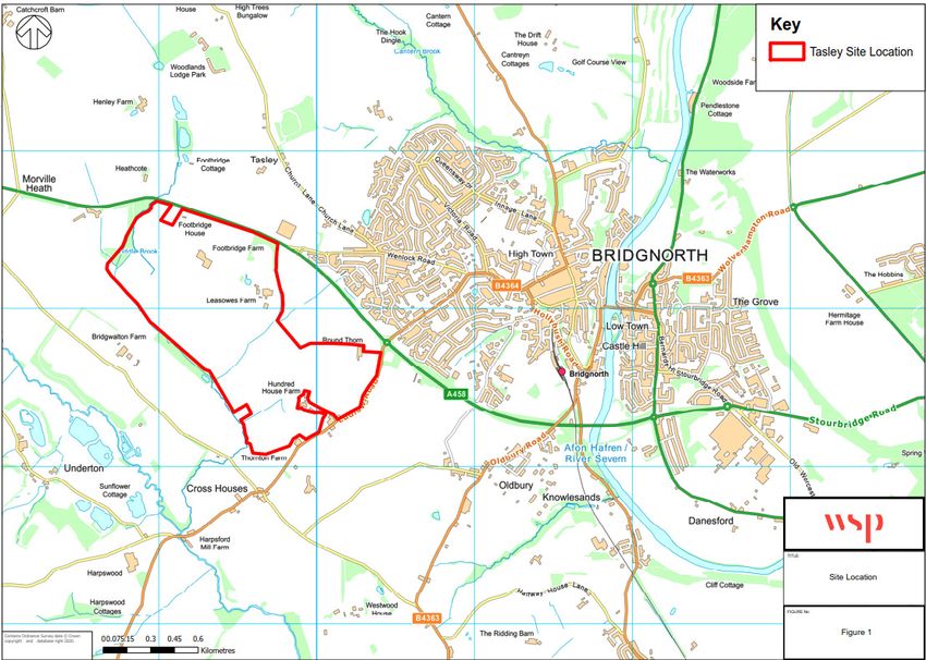
4.6    RESIDENTIAL TRIP DISTRIBUTION                                     28
4.7    EMPLOYMENT TRIP DISTRIBUTION                                      29
4.8    HIGHWAY ACCESS                                                    29
4.9    HIGHWAY CAPACITY                                                  29
4.10   PUBLIC TRANSPORT ACCESS                                           30
4.11   PEDESTRIAN AND CYCLE ACCESS                                       32
4.12   ACCESSIBILITY TO LOCAL FACILITIES                                 34
4.13   SUMMARY                                                           47

5      TRAFFIC SURVEYS                                                  48

5.2    COVID-19 PANDEMIC                                                 51

6      REPORT SUMMARY                                                   53

6.1    TRIP GENERATION                                                   53
6.2    TRIP DISTRIBUTION                                                 53
6.3    ACCESS                                                            54
6.4    HIGHWAY CAPACITY                                                  55
6.5    PUBLIC TRANSPORT                                                  56
6.6    ACCESSIBILITY TO LOCAL AMENITIES                                  56

       Appendices
       Appendix A - Local Facilities Plan

       Appendix B – Tasley Garden Village Isochrones

       Appendix C – Stanmore Garden Village Isochrones

       REVIEW OF POTENTIAL STRATEGIC SITES FOR BRIDGNORTH   INTERNAL | WSP
       Project No.: 70077973                                      April 2021
       Shropshire Council
1        INTRODUCTION
1.1.1.   Shropshire Council (SC) are currently preparing the Local Plan to guide future development. As part
         of the Call for Sites exercise, two sites located around Bridgnorth were submitted for consideration to
         accommodate residential development. SC require an assessment of the two strategic sites from a
         highways and transport perspective to inform the Local Plan Review for the Bridgnorth allocation. This
         report considers the traffic, transport and highway implications of both sites.
1.1.2.   As a result of the ‘Regulation 18’ Preferred Sites Consultation, a ‘Garden Village’ extension at
         Stanmore was identified as the preferred allocation for meeting much of the housing and employment
         needs of Bridgnorth during the emerging Local Plan period. However, since this consultation took
         place, a further significant site promotion for a ‘Garden Village’ extension at Tasley has been received
         by SC.
1.1.3.   These two sites, alongside a series of other smaller site promotions were the subject of a site
         assessment process, which forms part of the wider Sustainability Appraisal of the Local Plan, in order
         to identify the proposed allocations for inclusion within the Pre-Submission Draft Local Plan.

         REVIEW OF POTENTIAL STRATEGIC SITES FOR BRIDGNORTH                                    INTERNAL | WSP
         Project No.: 70077973                                                                       April 2021
         Shropshire Council                                                                        Page 1 of 58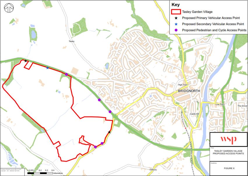
2 WORK TO DATE
2.1 BACKGROUND INFORMATION
2.1.1. Bridgnorth is the third largest town located in the County of Shropshire and is a market town with a
population of around 12,000 people.
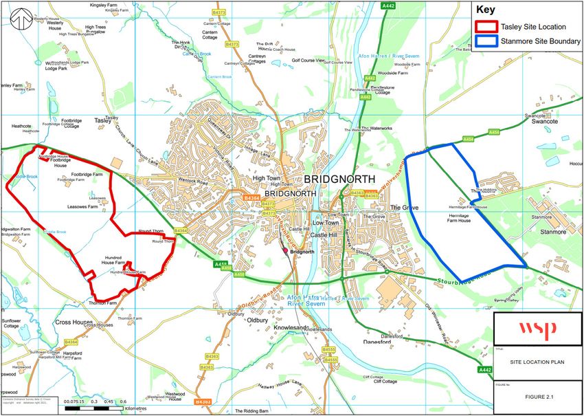
2.1.2. The Stanmore site is located to the east of Bridgnorth; the Tasley site located to the west, as shown
in Figure 2-1.
Figure 2-1 - Site Location Plan: Stanmore and Tasley sites
2.2 INTRODUCTION
2.2.1. These two sites, alongside a series of other smaller site promotions, were the subject of a site
assessment process undertaken by SC in November 2018 ‘Bridgnorth Place Plan Area Site
Assessments’. The exercise was repeated by SC in August 2020.
2.2.2. Within the site assessment process, the following points were noted:
Highways - Vehicles
“The land at the ‘Garden Village at Stanmore’ benefits from direct access onto an A road.
Similarly, the ‘Garden Village at Tasley’ benefits from direct access onto an A road.
Due to the scale of both developments, it is likely that both would have a significant impact on the
surrounding highway network and mitigation measures would be required to manage this growth.
REVIEW OF POTENTIAL STRATEGIC SITES FOR BRIDGNORTH INTERNAL | WSP
Project No.: 70077973 April 2021
Shropshire Council Page 2 of 58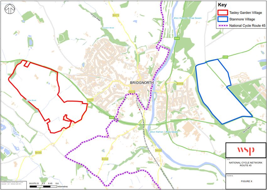
Specifically, both sites would need to introduce traffic calming measures within the vicinity of the
           site and make all necessary improvements to the wider highway infrastructure. However, given
           the scale of the development proposed it is considered that these improvements are viable and
           achievable;
         Highways - Pedestrians and Cyclists
          Both sites are a similar distance from Bridgnorth centre;
          Direct access onto an A road is a benefit for vehicles but can be a disadvantage when considering
           pedestrian and cycle access to the site. Promoting sustainable modes of travel is a key
           consideration. Furthermore, if a site cannot demonstrate that some trips will be via sustainable
           modes, this will increase the dependency on vehicles and increase the impact on the surrounding
           network.
          The land at the ‘Garden Village’ at Stanmore is separated from the built form of Bridgnorth by
           Hermitage Ridge. Necessary improvements to pedestrian and cycle facilities to create safe links
           between the site and the built form of Bridgnorth are essential in order to reduce the potential
           segregation between the existing settlement and the site. This would require careful consideration
           given the gradient and nature of roads and footpaths between Bridgnorth and the site.
          The land at the ‘Garden Village’ at Tasley is separated from the built form of Bridgnorth by the
           A458. Necessary improvements to pedestrian and cycle facilities to create safe links between the
           site and the built form of Bridgnorth are essential in order to reduce the potential segregation
           between the existing settlement and the proposed development. This would require careful
           consideration to ensure that the infrastructure provided is safe and attractive to pedestrians and
           cyclists.
          It should be noted that both sites offer the potential for enhanced public transport links into the
           town. It should also be noted that both site promotions are of a scale that a level of self-containment
           would be expected, through provision of a mixed-use development including a local centre, primary
           school, housing and employment. Whilst this self-containment can reduce the number of trips from
           the site into Bridgnorth, ultimately the reason for the development is to meet the needs of Bridgnorth
           and a site adjacent to its built form will benefit strongly from the ability to sustainably access the
           services and facilities available within the town.
2.2.3.   In regard to highway issues, the site assessment process concluded the following: “It is considered
         that the land at the ‘Garden Village’ proposal at Tasley provides more opportunities to make
         localised improvements to the surrounding network to ensure the new development is not
         segregated from the existing settlement of Bridgnorth, in particular there appears to be more
         opportunities for improvements to pedestrian and cycle facilities.”

2.3      TASLEY GARDEN VILLAGE
         March 2020
2.3.1.   A Development Statement for the site was prepared on behalf of Taylor Wimpey and the principal
         landowners in March 2020 in support of the allocation of a new Garden Village at Tasley.
2.3.2.   A Transport Issues report was prepared by Croft Transport Planning on behalf of Taylor Wimpey in
         March 2020. The report provided information specifically relating to the pedestrian accessibility
         aspects of the development proposals as well as assisting the local planning authority in the positive
         allocation of the site within the emerging SC Local Plan Partial Review.

         REVIEW OF POTENTIAL STRATEGIC SITES FOR BRIDGNORTH                                     INTERNAL | WSP
         Project No.: 70077973                                                                        April 2021
         Shropshire Council                                                                         Page 3 of 58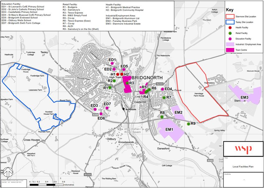
June 2020
2.3.3.   A Technical Note (TN) was prepared by PJA on behalf of Stanmore Properties and Apley Estate in
         June 2020. The TN reviewed the proposals for Tasley Garden Village from a highways’ perspective.
         The review focused on information contained within the ‘Transport Issues Report’ prepared by Croft
         Transport Planning in June 2020.
         August 2020
2.3.4.   In addition, the site, amongst others, has been included in the ‘Bridgnorth Place Plan Area Site
         Assessments’ published in August 2020, referred to as site BRD030. It was concluded that the site
         should be ‘considered within the next stage of the site assessment process due to conclusions
         reached regarding the sites availability, size and/or suitability.’
2.3.5.   Tasley Garden Village (BRD030) falls under Schedule S3.1 (i): Mixed Use Allocations: Bridgnorth
         Principal Centre. The land uses comprise:
            1,050 dwellings;
            16ha employment land;
            New local centre;
            20ha of green infrastructure and a 19ha linear park.
2.3.6.   In Stage 3 of the assessment, relating to Tasley Garden Village, it is stated that:
         “‘The site has good vehicular access potential, directly onto the A458 and Ludlow Road. If allocated,
         during the Planning Application process, consideration will need to be given to the most appropriate
         forms of access, this will be determined on the projected number of vehicles using the access, and
         the interaction with the access to land already in the Local Plan. As part of a strategic settlement it is
         assumed that these sites will be designed to promote cycling and walking for local trips and that local
         facilities will be provided to maximise sustainable travel. However, the parts of site that are closest to
         Bridgnorth High Town are well located for sustainable travel to facilities in this area in the initial phases
         of development of the strategic settlement when new facilities have not yet been introduced. The
         master plan will need to include direct walking and cycling routes that link to existing PRoW and into
         the town, including a footbridge crossing of the A458. These walking routes will also provide access
         to the existing Bridgnorth town bus service that currently operate within High Town, although
         appropriate bus provision on the site should also be considered.’
         November 2020
2.3.7.   A supporting Transport Document was prepared by WYG on behalf of Taylor Wimpey Strategic Land
         in November 2020 for the Tasley Garden Village site. This document identifies the key transport
         considerations associated with the development of the site.

2.4      STANMORE VILLAGE
         August 2019
2.4.1.   In August 2019, PJA prepared a short note on behalf of Stanmore Properties Ltd and Apley Estate,
         recommending a route that would connect Stanmore Village centre to Bridgnorth via Hermitage Ridge.
         The note indicated that the proposed route would vastly improve accessibility levels between the site
         and Bridgnorth Town Centre.

         REVIEW OF POTENTIAL STRATEGIC SITES FOR BRIDGNORTH                                         INTERNAL | WSP
         Project No.: 70077973                                                                            April 2021
         Shropshire Council                                                                             Page 4 of 58
March 2020
2.4.2. A Vision Document titled ‘A Vision for Stanmore Garden Village’ was prepared by MACE in March
2020 on behalf of the Stanmore Consortium. The document set out the site constraints and
development opportunities, the vision for Stanmore Garden Village and the proposed concept
masterplan.
March 2020
2.4.3. A high level Transport Appraisal was prepared by PJA on behalf of Stanmore Properties Ltd and Apley
Estate in March 2020 for the Stanmore Village site. The report appraised the site in transport terms,
based on the findings from a site visit, traffic count and desktop review. The document set out the key
issues and opportunities for the site.
2.4.4. The land use comprises:
850 dwellings;
16ha employment land (approximately 68,000sq.m of buildings);
5ha local centre;
36ha of green infrastructure.
August 2020
2.4.5. Stanmore Village was one of a number of sites considered in the ‘Bridgnorth Place Plan Area Site
Assessments’ published in August 2020. That Assessment indicated that the site should be
‘considered within the next stage of the site assessment process due to conclusions reached
regarding the sites availability, size and/or suitability.’
2.4.6. In Stage 3 of the Bridgnorth Place Plan Area Site Assessment, relating to Stanmore, it is stated that:
“‘The site is some distance from the built form of Bridgnorth, separated physically and functionally by
agricultural land and the Hermitage Ridge. Whilst it is considered that provision of a new local centre
and park and ride on the site would contribute to mitigation, the ability to provide effective pedestrian
and cycle links are more complex due to the gradient and presence of ancient woodland along
Hermitage Ridge. The site is located within the Green Belt. The NPPF specifies that Green Belt
boundaries should only be altered where exceptional circumstances are fully evidenced and justified,
before concluding that such circumstances exist all other reasonable options should be examined
fully. An alternative site has been identified which is not located within the Green Belt and could
achieve much of the development needs and aspirations for Bridgnorth through a comprehensive and
sustainable development. This site is of sufficient scale that it can deliver appropriate traffic calming
and pedestrian links into the town and extensive on site services and facilities to serve its new
community.”
REVIEW OF POTENTIAL STRATEGIC SITES FOR BRIDGNORTH INTERNAL | WSP
Project No.: 70077973 April 2021
Shropshire Council Page 5 of 583 TASLEY GARDEN VILLAGE
3.1 INTRODUCTION
3.1.1. The site is a very large (128.10 hectares), predominantly greenfield site, consisting of a significant
number of agricultural fields and some farmsteads.
3.1.2. The site is located to the south-west of Bridgnorth, approximately 1.5km from the town centre. The
location of the proposed Garden Village is shown in Figure 3-1.
Figure 3-1 - Site Location Plan - Tasley Garden Village
3.1.3. The site is bounded by B4364 Ludlow Road to the south-eastern side of the site and to the north-
eastern side of the site by A458. Generally open agricultural land bounds the site to the west and
south.
3.2 DEVELOPMENT PROPOSALS
3.2.1. As stated in the draft Shropshire Local Plan and the November 2020 Supporting Transport Document,
prepared by WYG, the development proposals (up to 2038) comprise:
1,050 dwellings;
16ha employment land;
New local centre (comprising of a range of retail and community uses);
REVIEW OF POTENTIAL STRATEGIC SITES FOR BRIDGNORTH INTERNAL | WSP
Project No.: 70077973 April 2021
Shropshire Council Page 6 of 58 A Primary School;
20ha of green infrastructure; and
A 19ha linear park.
3.2.2. The Supporting Transport Document prepared by WYG (November 2020) states that, “The proposals
would create a highly sustainable community, with new jobs on the site along with access to education,
retail and employment opportunities on the site which will reduce the need to travel. There is sufficient
land available within the site to introduce a public transport hub close to the local centre, which could
serve the development and enhance public transport connectivity across Bridgnorth. It could from a
complementary part of any future Council Park and Ride aspiration. The proposed development would
be sustainable in its provision on-site of a range of local services and facilities.”
3.3 RESIDENTIAL TRIP GENERATION
3.3.1. The ‘Transport Issues Report’ prepared by Croft Transport Planning in March 2020 proposed the
following residential trip rates, provided in Table 3-1.
Table 3-1 - Vehicular Residential Trip Rates (Croft Transport Planning, March 2020) - Per Unit
Vehicular Trip Rate (per Unit) Vehicle Trips (1,050 units)
Peak Period
Arrivals Departures Two-way Arrivals Departures Two-way
AM Peak Hour (08:00 - 09:00) 0.110 0.358 0.468 116 376 492
PM Peak Hour (17:00 - 18:00) 0.338 0.148 0.486 355 155 510
3.3.2. The Transport Technical Note (TN) prepared by PJA in June 2020, in response to the ‘Transport
Issues Report’ prepared by Croft Transport Planning in March 2020 raised a number of concerns
relating to the trip rates. PJA considered that “these trip rates are not wholly representative of the
proposed development site.” PJA concluded that “the site could generate more trips during peak
periods than previously forecast.”
3.3.3. The ‘High Level Transport Appraisal’ prepared by WYG in November 2020, proposed the following
trips rates, provided in Table 3-2.
Table 3-2 - Vehicular Residential Trip Rates (WYG, November 2020) - Per Unit
Vehicular Trip Rate (per Unit) Vehicle Trips (1,050 units)
Peak Period
Arrivals Departures Two-way Arrivals Departures Two-way
AM Peak Hour (08:00 - 09:00) 0.135 0.375 0.510 142 394 536
PM Peak Hour (17:00 - 18:00) 0.323 0.142 0.465 339 149 488
3.3.4. A comparison of the Croft Transport Planning trip rates in Table 3-1 against the trip rates proposed
by WYG in Table 3-2 indicate that they are very similar. Using the WYG trip rates results in slightly
higher development traffic flows in the AM peak hour and comparable levels of vehicle trips in the PM
peak hour.
REVIEW OF POTENTIAL STRATEGIC SITES FOR BRIDGNORTH INTERNAL | WSP
Project No.: 70077973 April 2021
Shropshire Council Page 7 of 583.3.5. Following a review of the TRICS trip rates provided in the ‘High Level Transport Appraisal’ prepared
by WYG, it is considered that the trip rates provided in Table 3-2 would be generally representative
of the residential component on the development site.
3.3.6. Based on the trip rates illustrated in Table 3-2, it is anticipated that the residential element of the site
(1,050 dwellings) would result in approximately 536 two-way trips during the morning peak hour, and
488 two-way trips during the evening peak hour.
3.4 EMPLOYMENT TRIP GENERATION
3.4.1. The ‘Transport Issues Report’ prepared by Croft Transport Planning in March 2020 proposed the
following employment trip rates, provided in Table 3-3.
Table 3-3 - Vehicular Employment Trip Rates (Croft Transport Planning, March 2020) - Per Ha
Vehicular Trip Rate (per Ha) Vehicle Trips (16 Hectares)
Peak Period
Arrivals Departures Two-way Arrivals Departures Two-way
AM Peak Hour (08:00 - 09:00) 10.481 3.931 14.412 168 63 231
PM Peak Hour (17:00 - 18:00) 2.551 9.964 12.515 41 159 200
3.4.2. The Transport TN prepared by PJA in June 2020 again raised a number of concerns relating to the
trip rates. PJA considered that “these trip rates are not wholly representative of the proposed
development site.” PJA concluded that “the site could generate more trips during peak periods than
previously forecast.”
3.4.3. The ‘High Level Transport Appraisal’ prepared by WYG in November 2020, proposed the same trip
rates as Croft Transport Planning, provided in Table 3-4.
Table 3-4 - Vehicular Employment Trip Rates (WYG, November 2020) - Per Ha
Vehicular Trip Rate (per Ha) Vehicle Trips (16 Hectares)
Peak Period
Arrivals Departures Two-way Arrivals Departures Two-way
AM Peak Hour (08:00 - 09:00) 10.481 3.931 14.412 168 63 231
PM Peak Hour (17:00 - 18:00) 2.551 9.964 12.515 41 159 200
3.4.4. Following a review of the employment trip rates suggested by both PJA and WYJ, it is considered that
the trip rates provided in Table 3-4 may not accurately represent the employment component on the
proposed development site.
3.4.5. WSP agree with the following points raised in the Transport TN prepared by PJA in June 2020:
“It is not considered that the site is a ‘freestanding’ location, however it is noted that TRICs
recommend a site-by-site approach should be taken. For the Free-standing site included within the
employment trip generation, it is not considered that this is comparable to the proposed
development location, as it is over 1.5km from the nearest settlement.”;
REVIEW OF POTENTIAL STRATEGIC SITES FOR BRIDGNORTH INTERNAL | WSP
Project No.: 70077973 April 2021
Shropshire Council Page 8 of 58 In the ‘General Guide to Site Compatibility by Main Location Type’ produced by TRICS, free
standing sites are listed as not compatible with ‘Suburban Area’ and ‘Neighbourhood Centre.’ Both
of these sub-categories have been selected for residential and employment trip rates; and
In addition, a site within Greater London has also been included for the employment trips, which is
likely to have greater public transport accessibility than the proposed development site.”
3.4.6. An independent TRICS assessment has therefore been undertaken by WSP, to remove the free-
standing site and the site in Greater London. The vehicular trip rates are provided in Table 3-5.
Table 3-5 - Vehicular Employment Trip Rates - per Ha
Vehicular Trip Rate (per Ha) Vehicle Trips (16 Hectares)
Peak Period
Arrivals Departures Two-way Arrivals Departures Two-way
AM Peak Hour (08:00 - 09:00) 10.355 3.616 13.971 166 58 224
PM Peak Hour (17:00 - 18:00) 2.590 9.340 11.930 41 149 191
3.4.7. Using the updated trip rates results in a slightly lower trip generation compared with the results
included in Table 3-3 and Table 3-4. Hence the adoption of the higher trip rates and generation would
therefore provide robust trip forecasts for subsequent junction modelling.
3.4.8. Using the trip rates illustrated in Table 3-4, it is anticipated that the employment element of the site
(16 hectares) would result in approximately 231 two-way trips during the morning peak hour, and 200
two-way trips during the evening peak hour.
3.5 RESIDENTIAL TRIP DISTRIBUTION
3.5.1. WSP consider that the anticipated trip distribution for the site should be projected using available
census data. In this regard, whilst no information is provided within the ‘Transport Issues Report’
prepared by Croft Transport Planning in March 2020, it is assumed that the trip distribution has been
determined using 2011 census data. The report includes an indicative trip distribution to key local
destinations:
Ludlow (via Ludlow Road): Up to 10% of trips;
Shrewsbury (via the A458 NW): Between 15% and 20% of trips;
Stourbridge / Wolverhampton / Birmingham (via the A458 SE): Between 35% and 40% of trips;
Telford (via the A442 N): Around 15% of trips; and
Kidderminster (via the A442 S): Around 20% of trips.
3.5.2. The Transport TN prepared by PJA in June 2020 raised various concerns relating to the trip
distribution, as follows:
“No consideration has been given to trips from either the residential or employment element of the
site routing to locations in Bridgnorth Town Centre. For residential and employment trips,
approximately 30% of census journey to work trips from Shropshire 031 are to MSOAs covering
the town centre. This will increase the number of trips forecast to route through junctions which are
known to experience congestion during weekday peak periods in Bridgnorth Town Centre. As a
result, it is considered the Croft Assessment overestimates the number of trips routing towards
Stourbridge, Wolverhampton, Birmingham, and Kidderminster;
REVIEW OF POTENTIAL STRATEGIC SITES FOR BRIDGNORTH INTERNAL | WSP
Project No.: 70077973 April 2021
Shropshire Council Page 9 of 58 No trips are forecast to use the A454. Based on census journey to work data, it is forecast that 13%
of residential trips and 4% of employment trips could use the A454 (either via A454 or A442 and
Wolverhampton Road) towards Wolverhampton. This could also increase the number of trips
forecast to route through junctions which are known to experience congestion during weekday peak
periods in Bridgnorth Town Centre; and
Only one trip distribution/assignment has been presented.....the employment and residential
elements of the site are likely to have different distributions.”
3.5.3. The ‘High Level Transport Appraisal’ prepared by WYG in November 2020 followed a slightly different
approach. 2011 census data was used as a starting point, and then manually adjusted to reflect the
following factors:
Employment and school destinations within the site itself will lead to internalisation of some
movements, reducing the need for residents to travel into Bridgnorth;
The site is located within walking and cycling distance of Bridgnorth; and
There is a constraint on how much employment can grow in Bridgnorth town centre, and the
residents within the development would likely either seek employment further afield, or travel to /
from local employment by sustainable modes.
3.5.4. In order to reflect these factors, the trip distribution has been manually adjusted to reduce the
proportion of local car trips, and increase the proportion of car trips to other destinations. In doing so,
it was indicated that this would increase the robustness of the assessments. The traffic distribution
assumed in the High Level Transport Appraisal’ prepared by WYG in November 2020 is as follows:
A442 to Telford: 26.7% (original NOMIS value = 23.0% + 3.7% redistributed);
A454 to Wolverhampton: 24.2% (original NOMIS value = 20.8% + 3.4% redistributed);
A458 to Stourbridge: 10.4% (original NOMIS value = 9.0% + 1.5% redistributed);
A442 to Kidderminster: 6.5% (original NOMIS value = 5.6% + 0.9% redistributed);
B4364 to Ludlow: 5.2% (original NOMIS value = 4.4% + 0.7% redistributed);
A458 to Shrewsbury: 12.1% (original NOMIS value = 10.4% + 1.7% redistributed);
Within Bridgnorth: 15.0% (original NOMIS value = 26.9% - 11.9% redistributed);
3.5.5. Following a review of the approach to trip distribution provided in the ‘High Level Transport Appraisal’
prepared by WYG, it is considered that the redistribution of trips away from Bridgnorth is potentially
overestimated and should therefore be re-visited at a later date.
3.6 EMPLOYMENT TRIP DISTRIBUTION
3.6.1. The ‘High Level Transport Appraisal’ prepared by WYG in November 2020 sets out the approach to
the trip distribution used for the employment aspect of the site. The employment distribution used
Journey to Work data from the 2011 census. Whilst the approach is generally considered sensible, a
full review of this approach would need to be undertaken at a later date.
3.7 HIGHWAY ACCESS
3.7.1. The site is bounded by A458 to the north, Tiddle Brook to the west and south, and Ludlow Road to
the east.
3.7.2. The Development Statement for the site which was prepared on behalf of Taylor Wimpey and the
principal landowners in March 2020 sets out the proposed vehicular access points for the development
site. At this stage, it has been proposed that the development site (including the land identified for
REVIEW OF POTENTIAL STRATEGIC SITES FOR BRIDGNORTH INTERNAL | WSP
Project No.: 70077973 April 2021
Shropshire Council Page 10 of 58further development) would have three formal vehicular access points. The main vehicular access
point will be taken from Ludlow Road, towards the junction with the A458. Two additional vehicular
access points are proposed for the site, the first would be located along the frontage of A458 to the
north-western corner of the site, and the second, also located further east along A458. These
proposed access points are shown in Figure 3-2.
Figure 3-2 - Proposed Access Points - Tasley Garden Village
3.7.3. As per the promotion document for the site prepared in November 2020, paragraph 4.2.5 states that,
“if it is considered that an access should not be provided at this stage through the land identified for
future development, then the western most access can be omitted and the employment access could
also provide adequate access for the wider development onto the A458.”
3.7.4. The A458 is currently subject to the national speed limit (60mph). As stated in the ‘Supporting
Transport Document’ prepared by WYG in November 2020;
“In order to enhance the integration of the proposed Garden Village with Bridgnorth, a speed
limit reduction could be promoted along the A458. That would create a more favourable
environment for pedestrian crossings, and roadside footways and cycling. The Council has
confirmed that they would be supportive of a speed limit reduction along the A458 corridor in
the vicinity of the site. A reduction from 60 mph to 40 mph would continue to reflect the
strategic function of the road but also deliver place making betterments associated with the
planned growth within Bridgnorth”
REVIEW OF POTENTIAL STRATEGIC SITES FOR BRIDGNORTH INTERNAL | WSP
Project No.: 70077973 April 2021
Shropshire Council Page 11 of 583.8 HIGHWAY CAPACITY
3.8.1. Section 6 of the ‘Supporting Transport Document’ prepared by WYG on behalf of Taylor Wimpey
details the potential impacts on the highway network associated with the development. Junction
capacity assessments have been undertaken by WYG at the following existing junctions for a 2020
base year and 2038 future year:
J1: A458 / Wenlock Road Priority Junction;
J2: Wenlock Road / Ludlow Road / Westgate / Westgate Drive Junction;
J3: A458 / Ludlow Road Roundabout; and
J4: A458 / A442 Roundabout.
3.8.2. The 2020 base year adopted manual classified turning count data that were collected on 1st October
2020 (for Junctions 1 to 3). As stated in the WYG ‘Supporting Transport Document’ given the COVID-
19 pandemic, following discussions with the LHA, it was agreed that factors to increase the 2020
surveyed traffic flows to typical traffic flows should be derived, to ensure a robust assessment. This
was undertaken as follows: “The applied factor was derived by comparing the flows from the PJA
Transport Appraisal (March 2020). The flows on the west arm of the A458/A442 roundabout (2019,
pre-Covid) and the surveyed flows at the east arm of the A458/Ludlow Road roundabout (October
2020).” Given the circumstances, brought about by the COVID-19 pandemic, WSP consider this to be
a sensible approach.
3.8.3. As stated in the WYG ‘Supporting Transport Document’, junction 4 (A458 / A442 roundabout) flows
were extracted from the PJA Transport Appraisal. These flows were collected in 2019, prior to the
COVID pandemic, and growthed to a 2020 base using TEMPRO. The 2038 future year flows were
also calculated using the TEMPRO database.
3.8.4. Table 3-6 sets out the maximum RFC and queues across each junction for the 2020 base and 2020
base + Tasley development scenarios. These results have been extracted from the WYG ‘Supporting
Transport Document’ (November 2020) and would need to be reviewed following the confirmation of
trip rates, distribution proportions and internalisation of trips.
Table 3-6 - 2020 Junction Assessment Results (worst arm)
2020 Base 2020 Base + Tasley Development
AM PM AM PM
Junction
Max Max Max Max
Max Max Max Max
Queue Queue Queue Queue
RFC RFC RFC RFC
(PCU) (PCU) (PCU) (PCU)
J1 - A458 /
0.42 1 0.35 1 0.57 3 0.43 1
Wenlock Road
J2 - Wenlock
Road / Ludlow 0.65 2 0.75 3 0.74 3 0.82 4
Road / Westgate
J3 - A458 /
0.36 1 0.48 1 0.50 1 0.63 2
Ludlow Road
J4 - A458 / A442 0.61 2 0.75 3 0.82 4 1.01 23
REVIEW OF POTENTIAL STRATEGIC SITES FOR BRIDGNORTH INTERNAL | WSP
Project No.: 70077973 April 2021
Shropshire Council Page 12 of 583.8.5. Table 3-6 indicates that the four junctions modelled generally have sufficient capacity to
accommodate the development of Tasley Garden Village with a 2020 base year. In 2020, during the
PM peak at the A458 / A442 roundabout, there is an increase in queuing on the northern arm of
junction by 20 pcus with the junction operating just over capacity, with the average delay per PCU
increasing by just over a minute.
3.8.6. Table 3-7 sets out the maximum RFC and queues across each junction for the 2038 base and 2038
base + Tasley development scenarios.
Table 3-7 - 2038 Junction Assessment Results (worst arm)
2038 Base 2038 Base + Tasley Development
AM PM AM PM
Junction
Max Max Max Max
Max Max Max Max
Queue Queue Queue Queue
RFC RFC RFC RFC
(PCU) (PCU) (PCU) (PCU)
J1 - A458 /
0.54 2 0.43 1 0.76 5 0.59 1
Wenlock Road
J2 - Wenlock
Road / Ludlow 0.77 6 0.90 7 0.88 6 0.97 12
Road / Westgate
J3 - A458 /
0.42 2 0.56 1 0.58 2 0.71 3
Ludlow Road
J4 - A458 / A442 0.74 14 0.91 8 0.96 14 1.18 88
3.8.7. Table 3-7 indicates that two of the four junctions modelled operate within practical reserve capacity in
the 2038 base scenario. In 2038, during the PM peak at the Wenlock Road / Ludlow Road / Westgate
junction, the junction begins to approach capacity with the addition of the development.
3.8.8. In 2020, during the PM peak at the A458 / A442 roundabout with the proposed development, there is
an increase in queuing on the northern arm of junction by 20 pcus, with the junction operating over
capacity and the average delay per PCU increasing by just over a minute. In the 2038 future year
assessment, queuing during the PM peak on the northern arm of the A458 / A442 roundabout
increases to 88 pcus, with an average delay per PCU of 296.5 seconds. As stated in the ‘High Level
Transport Appraisal’, there is a level of robustness in the assessment in relation to no reductions for
internalisation of trips. WYG carried out a sensitivity test which increased the flare length on the
northern and eastern arms which returned the junction to within operational capacity for the 2038
future assessment year.
3.8.9. Although as stated, any modelling assessment would need to be re-visited following the confirmation
of trip rates, distribution proportions and internalisation of trips.
3.9 PUBLIC TRANSPORT ACCESS
Rail Services
3.9.1. Bridgnorth Railway station closed to passenger services in 1963. Bridgnorth does however still have
a station on an active heritage line, the Severn Valley Railway.
REVIEW OF POTENTIAL STRATEGIC SITES FOR BRIDGNORTH INTERNAL | WSP
Project No.: 70077973 April 2021
Shropshire Council Page 13 of 583.9.2. The closest passenger rail services to Bridgnorth are located in Telford and Wolverhampton. Telford
Railway Station is located approximately 23km to the north, whilst Wolverhampton Railway Station is
located around 27km to the east of the site.
Bus Services
3.9.3. Bus stops are located on Wenlock Road, close to the junctions with Church Lane and Portman’s Way.
Bus stops are also located on Westgate, around 60m to the east of the junction with Ludlow Road.
These bus stops are within a 15 - 20 minute walk of the site.
3.9.4. Bus services 18 and 436 operate from the westbound bus stops and bus service 436 operates from
the eastbound bus stops. Further details of the services are provided in Table 3-8 (although service
times and frequencies could change subject to COVID 19 related issues).
Table 3-8 - Existing Bus Services
Frequency
Bus Service Route
Mon - Fri Sat Sunday
Bridgnorth to Telford Town 1 AM service 1 AM service
18 No Service
Centre Bus Station (09:07) (09:07)
436 Bridgnorth to Shrewsbury Hourly Hourly No Service
3.9.5. Further bus services are available from Bridgnorth Town Centre, with destinations including
Wolverhampton, Danesford, Kidderminster and Shifnal.
3.9.6. As stated in the ‘Transport Issues Report’ prepared by Croft Transport Planning in March 2020, given
the size of the site and the proposed highway links from both Ludlow Road and A458, there is the
potential for a bus route to be extended into the site to enhance the accessibility to local bus services.
3.9.7. The provision of a new / diverted bus route is also raised in the WYG ‘High Level Transport Appraisal’
document, it is stated that bus services would be brought forward on a phased basis alongside the
construction and occupation of the development to ensure that an appropriate level of provision is
continually available to offer sustainable travel choice.
3.9.8. Bus routes 18 and 436 pass along A458, to the north of the site. It is considered that either route could
potentially be diverted into the site. However, the viability of this would need to be confirmed with bus
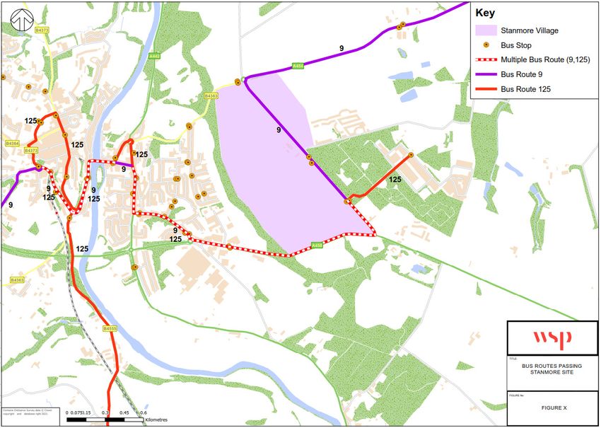
operators. A plan showing the routing of both routes is provided in Figure 3-3.
REVIEW OF POTENTIAL STRATEGIC SITES FOR BRIDGNORTH INTERNAL | WSP
Project No.: 70077973 April 2021
Shropshire Council Page 14 of 58Figure 3-3 - Bus Routes passing the Site
3.10 PEDESTRIAN AND CYCLE ACCESS
3.10.1. At present, there is no formal infrastructure that allows a direct pedestrian connection between the
site and the rest of Bridgnorth, although pedestrians are able to cross the A458 if they wish to use the
substantial adopted verges on both sides of the road and indeed pedestrians are currently doing this
when making use of the existing Public Rights of Way which passes through the site from the A458.
3.10.2. The ‘Transport Issues Report’ prepared by Croft Transport Planning in March 2020 considered a
number of options for improving the pedestrian connectivity of the site with the potential for
improvements to the pedestrian infrastructure within the area:
Option 1: Additional footway provision on Ludlow Road: 3m wide footway / cycleway along the site
frontage and between the site and A458 Bridgnorth Bypass, together with uncontrolled facilities for
pedestrians and cyclists at the roundabout;
Option 2: Provision of formal signalised crossings of the A458;
Option 3: Footbridge across the A458. It is considered within the Croft report that there is no
requirement for a footbridge given that both Options 1 and 2 would provide safe and suitable access
between the site and Bridgnorth. However, this could be considered in further detail if considered
necessary following discussions with the Council and Highways Team;
Option 4: Pedestrian Route across A458 onto Wenlock Road: At present, the footway on the
northern side of Wenlock Road starts around 150 metres east of the junction with the A458. This
section will be implemented as part of the Tasley Garden Village proposals together with a formal
REVIEW OF POTENTIAL STRATEGIC SITES FOR BRIDGNORTH INTERNAL | WSP
Project No.: 70077973 April 2021
Shropshire Council Page 15 of 58crossing on the A458 which will ensure safe and efficient passage for pedestrians between the
western side of the site and the south-western areas of Bridgnorth. It is considered that the vast
majority of pedestrian trips will likely access the site via Ludlow Road, and this option would provide
an alternative.
3.10.3. Within the WYG ‘High Level Transport Appraisal’, it is stated that further consideration has been given
to the pedestrian bridge over the A458. It is indicated within the report that a DDA compliant structure
which includes both 1:20 access ramps and also stairs could be accommodated within available land
across A458 immediately to the west of the Ludlow Road roundabout. It is understood that preliminary
design work with respect to bridge feasibility is ongoing.
3.11 ACCESSIBILITY TO LOCAL FACILITIES
3.11.1. CIHT ‘Planning for Walking’ (April 2015) within Section 6.3, states that “most people will only walk if
their destination is less than a mile away. Land use patterns most conducive to walking are thus mixed
in use and resemble patchworks of “walkable neighbourhoods”.”
3.11.2. Section 6.4 states that “Walking neighbourhoods are typically characterised as having a range of
facilities within 10 minutes’ walking distance (around 800 metres). However, the propensity to walk or
cycle is not only influenced by distance but also the quality of the experience; people may be willing
to walk or cycle further where their surroundings are more attractive, safe and stimulating. Developers
should consider the safety of the routes (adequacy of surveillance, sight lines and appropriate lighting)
as well as landscaping factors (indigenous planting, habitat creation) in their design.”
3.11.3. Access to local amenities has been considered by examining the number of services and facilities
available within a reasonable walking and cycling distance of the site. CIHT ‘Guidelines for Providing
for Journeys on Foot’ sets out the suggested acceptable walking distances. These have been
replicated in Table 3-9.
Table 3-9 - Suggested Acceptable Walking Distances
Commuting / School
Town Centres (m) Elsewhere (m)
/ Sight-seeing (m)
Desirable 200 500 400
Acceptable 400 1000 800
Preferred Maximum 800 2000 1200
3.11.4. The range of amenities and facilities considered are shown in Figure 3-4, reproduced in Appendix A.
REVIEW OF POTENTIAL STRATEGIC SITES FOR BRIDGNORTH INTERNAL | WSP
Project No.: 70077973 April 2021
Shropshire Council Page 16 of 58Figure 3-4 - Local Facilities Plan
3.11.5. The following facilities / services have been included in the review:
Primary Schools;
Secondary Schools / Further Education
Food Retail;
Medical / Health Facilities; and
Centres of employment.
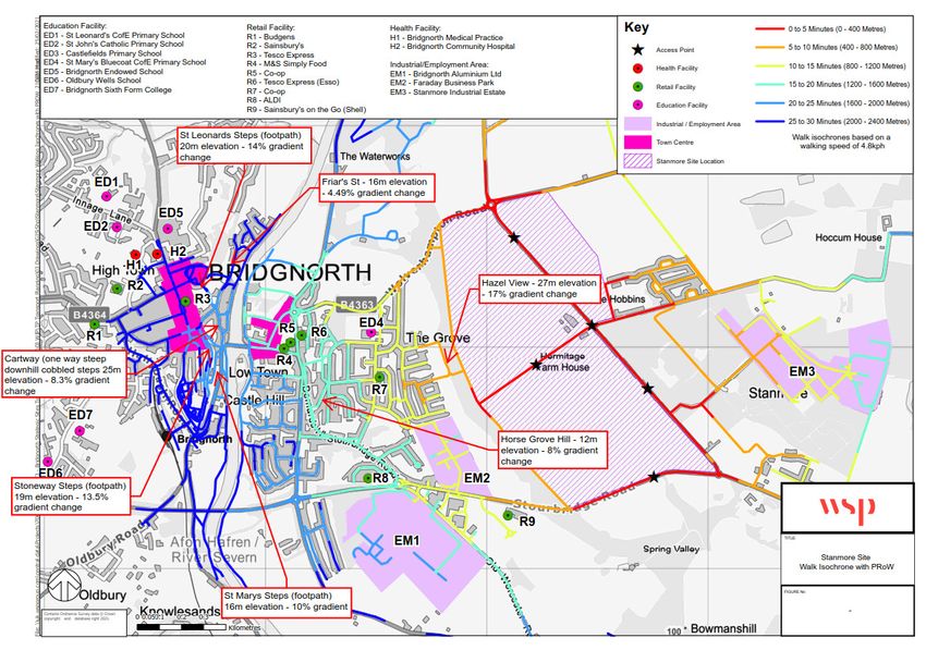
3.11.6. Walking and cycling isochrones have been created to illustrate the location of site in relation to facilities
and services across Bridgnorth. The isochrones have been based on the anticipated access points
(both vehicular and pedestrian) stated in the ‘Development Statement for the site which was prepared
on behalf of Taylor Wimpey and the principal landowners in March 2020.
3.11.7. Walking times are based on an average walking speed of 80m per minute (4.8kph), and the cycling
times are based on an average cycling speed of 267m per minute (16kph). These speeds are the
default settings within the software within ArcGIS used to calculate walking / cycling isochrones.
3.11.8. The walking and cycling isochrones for the Tasley site are provided in Figure 3-5 and Figure 3-6
respectively. Both figures are reproduced in Appendix B.
REVIEW OF POTENTIAL STRATEGIC SITES FOR BRIDGNORTH INTERNAL | WSP
Project No.: 70077973 April 2021
Shropshire Council Page 17 of 58Figure 3-5 - Walk Isochrone - Tasley Figure 3-6 - Cycle Isochrone - Tasley REVIEW OF POTENTIAL STRATEGIC SITES FOR BRIDGNORTH INTERNAL | WSP Project No.: 70077973 April 2021 Shropshire Council Page 18 of 58
3.11.9. Figure 3-5 illustrates that the majority of Bridgnorth is walkable from the Tasley site within 25 minutes.
        Figure 3-6 illustrates that the majority of Bridgnorth is cyclable from the Tasley site within 10 minutes.
3.11.10. Walking and cycling distances have been calculated from the site to key facilities and services
         provided within Bridgnorth using Google Maps. The distances have been taken from the northern
         access onto the A458, the eastern access onto Ludlow Road, and from the centre of the site (via
         either access, dependant on which provides the shortest route), as shown in Figure 3-7. These access
         points are the proposed primary vehicular access points as stated within the Development Statement
         for the site which was prepared on behalf of Taylor Wimpey and the principal landowners in March
         2020.
3.11.11. It should be noted that there may be some instances where the cycling distance is longer than the
         walking distance. This occurs where there are footpaths / stepped paths which would not be suitable
         for cyclists. Under these circumstances, cyclists would use an alternative route which may be slightly
         longer than the walking route. It should also be noted that the walk / cycle times are based on average
         speeds and do not take account of areas of steep gradients / stepped paths.
3.11.12. In accordance with the isochrones, walking times are based on an average walking speed of 80m per
         minute (4.8kph), and the cycling times are based on an average cycling speed of 267m per minute
         (16kph). These walk and cycle times have been checked against those reported in Google Maps when
         using the ‘Directions’ tool and have been shown to be comparable.

         Figure 3-7 - Indicative Access Points

3.11.13. Table 3-10 sets out the walking times and distances to Primary Schools in Bridgnorth.

         REVIEW OF POTENTIAL STRATEGIC SITES FOR BRIDGNORTH                                     INTERNAL | WSP
         Project No.: 70077973                                                                        April 2021
         Shropshire Council                                                                        Page 19 of 58
Table 3-10 - Walking distances and times to Primary Schools in Bridgnorth
Walk Distance (Start point) Walk Time (mins)
School Mid- Northern Eastern Mid- Northern Eastern
point of access access point of access access
site point point site point point
Castlefields Primary School,
1.8km 2.1km 1.0km 23 mins 26 mins 13 mins
(WV16 5DQ)
St John’s Catholic Primary
2.6km 2.4km 1.8km 33 mins 30 mins 23 mins
school (WV16 4HW)
St Leonard’s primary school
2.5km 2.3km 1.7km 31 mins 29 mins 21 mins
(WV16 4HL)
St Mary’s Bluecoat CofE
3.9km 3.9km 3.1km 49 mins 49 mins 39 mins
Primary School (WV15 5EQ)
3.11.14. As shown in Table 3-10, the nearest Primary School to the site is located 1.8km walking distance from
the centre of the development site. This equates to a walking time of around 23 minutes. All of the
primary schools within Bridgnorth are within a 50-minute walk of the centre of the site.
3.11.15. As per the draft Shropshire Local Plan and the November 2020 Supporting Transport Document, the
development proposals (up to 2038) will include a Primary School. Whilst this will reduce the distance
to the nearest Primary School, the phasing of the development is not yet known and there is currently
no commitment in place that the Primary School could be delivered at a later stage of the development.
3.11.16. Table 3-11 sets out the walking times and distances to Secondary Schools in Bridgnorth.
Table 3-11 - Walking distances and times to Secondary Schools in Bridgnorth
Walk Distance (Start point) Walk Time (mins)
School Mid- Northern Eastern Mid- Northern Eastern
point of access access point of access access
site point point site point point
Bridgnorth Endowed School
2.6km 2.5km 1.8km 33 mins 31 mins 23 mins
(Bridgnorth, WV16 4ER)
Oldbury Wells School
3.1km 3.1km 2.3km 39 mins 39 mins 29 mins
(Bridgnorth, WV16 5JD)
Bridgnorth Sixth Form
3.2km 3.2km 2.4km 40 mins 40 mins 30 mins
(Bridgnorth, WV16 5JD)
3.11.17. As shown in Table 3-11, the nearest Secondary School to the site is located 1.8km walking distance
from the eastern access point of the development site. This equates to a walking time of around 23
minutes. Both of the secondary schools and the Sixth Form college are within a 30-minute walk of the
eastern access point of the development site.
3.11.18. Table 3-12 sets out the cycling times and distances to Primary Schools in Bridgnorth.
REVIEW OF POTENTIAL STRATEGIC SITES FOR BRIDGNORTH INTERNAL | WSP
Project No.: 70077973 April 2021
Shropshire Council Page 20 of 58Table 3-12 - Cycle distances and times to Secondary Schools / Further Education in
Bridgnorth
Cycle Distance (Start point) Cycle Time (mins)
School Mid- Northern Eastern Mid- Northern Eastern
point of access access point of access access
site point point site point point
Bridgnorth Endowed School 7 mins
2.6km 2.5km 1.8km 10 mins 9 mins
(Bridgnorth, WV16 4ER)
Oldbury Wells School
3.1km 3.1km 2.3km 12 mins 12 mins 9 mins
(Bridgnorth, WV16 5JD)
Bridgnorth Sixth Form
3.2km 3.2km 2.4km 12 mins 12 mins 9 mins
(Bridgnorth, WV16 5JD)
3.11.19. As shown in Table 3-12, the nearest Secondary School to the site is located 2.6km cycling distance
from the centre of the development site. This equates to a cycle time of around 10 minutes. Both of
the secondary schools and the Sixth Form college are within a 12-minute cycle of the centre of the
site.
3.11.20. Table 3-13 sets out the walk times and distances to the key retail offerings within Bridgnorth.
Table 3-13 - Walking distances and times to Retail Facilities in Bridgnorth
Walk Distance (Start point) Walk Time (mins)
Retail Facility Mid- Northern Eastern Mid- Northern Eastern
point of access access point of access access
site point point site point point
Town Centre 2.4km 2.6km 1.6km 30 mins 33 mins 20 mins
ALDI (Stourbridge Rd,
3.2km 3.8km 2.4km 40 mins 48 mins 30 mins
Bridgnorth WV15 6AL)
Sainsbury’s (Whitburn St,
2.3km 2.4km 1.5km 29 mins 30 mins 19 mins
Bridgnorth WV16 4QN)
Tesco Express (63 High St,
2.5km 2.6km 1.7km 31 mins 33 mins 21 mins
Bridgnorth WV16 4DX)
Tesco Express (Esso, Cann
3.2km 3.3km 2.4km 40 mins 41 mins 30 mins
Hall Dr, Bridgnorth WV15 5AP)
M&S Simply Food (St Johns
3.0km 3.1km 2.2km 38 mins 39 mins 28 mins
St, Bridgnorth WV15 6AG)
Co-op Food (Mill St, Bridgnorth
3.2km 3.2km 2.4km 40 mins 40 mins 30 mins
WV15 5AL)
Sainsbury’s on the Go (EG
Bridgnorth Service Station, 3.9km 4.0km 3.1km 49 mins 50 mins 39 mins
WV15 6AN)
3.11.21. As shown in Table 3-13, Bridgnorth town centre is located approximately 1.6km walking distance from
the eastern access point, equivalent to a 20-minute walk via Ludlow Road. The closest supermarket
is Sainsburys on Whitburn Street, which is located within a 20-minute walk from the eastern access
point on Ludlow Road.
REVIEW OF POTENTIAL STRATEGIC SITES FOR BRIDGNORTH INTERNAL | WSP
Project No.: 70077973 April 2021
Shropshire Council Page 21 of 583.11.22. As per the draft Shropshire Local Plan and the November 2020 Supporting Transport Document, the
development proposals (up to 2038) will include a Local Centre. Whilst it is not yet known what will be
included within the Local Centre, it is considered likely that a convenience store would be included in
the proposals.
3.11.23. Table 3-14 sets out the cycling times and distances to the key retail locations within Bridgnorth.
Table 3-14 - Cycle distances and times to Retail Facilities in Bridgnorth
Cycle Distance (Start point) Cycle Time (mins)
Retail Facility Mid- Northern Eastern Mid- Northern Eastern
point of access access point of access access
site point point site point point
Town Centre 2.4km 2.8km 1.7km 9 mins 10 mins 7 mins
ALDI (Stourbridge Rd,
3.3km 3.8km 2.5km 12 mins 14 mins 9 mins
Bridgnorth WV15 6AL)
Sainsbury’s (Whitburn St,
2.3km 2.4km 1.5km 9 mins 9 mins 6 mins
Bridgnorth WV16 4QN)
Tesco Express (63 High St,
2.5km 2.6km 1.7km 9 mins 10 mins 6 mins
Bridgnorth WV16 4DX)
Tesco Express (Cann Hall Dr,
3.7km 4.2km 2.9km 14 mins 16 mins 11 mins
Bridgnorth WV15 5AP)
M&S Simply Food (St Johns
3.7km 4.1km 2.9km 14 mins 15 mins 11 mins
St, Bridgnorth WV15 6AG)
Co-op Food (Mill St, Bridgnorth
3.7km 4.1km 2.9km 14 mins 15 mins 11 mins
WV15 5AL)
Sainsbury’s on the Go (EG
Bridgnorth Service Station, 3.9km 4.0km 3.1km 15 mins 15 mins 12 mins
WV15 6AN)
3.11.24. As shown in Table 3-14, Bridgnorth town centre is located approximately 1.7km cycle distance from
the eastern access point, equivalent to a 7 minute cycle ride. The closest supermarket is Tesco
Express on Bridgnorth High Street, which is located around a 21-minute walk from the eastern access
point on Ludlow Road.
3.11.25. Table 3-15 sets out the walking times and distances to the medical / health facilities within Bridgnorth.
REVIEW OF POTENTIAL STRATEGIC SITES FOR BRIDGNORTH INTERNAL | WSP
Project No.: 70077973 April 2021
Shropshire Council Page 22 of 58Table 3-15 - Walking distances and times to Medical / Health Facilities in Bridgnorth
Walk Distance (Start point) Walk Time (mins)
Medical / Health Facility Mid- Northern Eastern Mid- Northern Eastern
point of access access point of access access
site point point site point point
Bridgnorth Medical Practice
(Old Smithfield, Bridgnorth, 2.5km 2.7km 1.7km 31 mins 34 mins 21 mins
WV16 4EN)
Bridgnorth Community Hospital
(N Gate, Bridgnorth, WV16 2.6km 2.8km 1.8km 33 mins 35 mins 23 mins
4EU)
Mydentist (St Leonard’s Close,
2.6km 2.8km 1.8km 33 mins 35 mins 23 mins
Bridgnorth, WV16 4EJ)
Dental Matters (N Gate,
2.6km 2.8km 1.8km 33 mins 35 mins 23 mins
Bridgnorth, WV16 4EU)
Smile Design (Whitburn Street,
2.4km 2.6km 1.6km 30 mins 33 mins 20 mins
Bridgnorth, WV16 4QT)
Pure Dental Care (West Castle
2.7km 2.9km 1.9km 34 mins 36 mins 24 mins
St, Bridgnorth, WV16 4AD)
Regency House Dental
Practice (Underhill Street, 2.9km 3.1km 2.1km 36 mins 39 mins 26 mins
Bridgnorth, WV16 4BB)
3.11.26. As shown in Table 3-15, Bridgnorth Medical Practice and Bridgnorth Community Hospital are located
within 1.8km walking distance from the eastern access point, equivalent to a 21 to 23-minute walk via
Ludlow Road. The closest dentist is Smile Design on Whitburn Street, which is located within a 20-
minute walk from the eastern access point on Ludlow Road.
3.11.27. Table 3-16 sets out the cycle times and distances to the medical / health facilities within Bridgnorth.
Table 3-16 - Cycle distances and times to Medical / Health Facilities in Bridgnorth
Cycle Distance (Start point) Cycle Time (mins)
Medical / Health Facility Mid- Northern Eastern Mid- Northern Eastern
point of access access point of access access
site point point site point point
Bridgnorth Medical Practice
(Old Smithfield, Bridgnorth, 2.5km 2.7km 1.7km 9 mins 10 mins 6 mins
WV16 4EN)
Bridgnorth Community Hospital
(N Gate, Bridgnorth, WV16 2.6km 2.8km 1.8km 10 mins 10 mins 7 mins
4EU)
Mydentist (St Leonard’s Close,
2.6km 2.8km 1.8km 10 mins 10 mins 7 mins
Bridgnorth, WV16 4EJ)
Dental Matters (N Gate,
2.6km 2.8km 1.8km 10 mins 10 mins 7 mins
Bridgnorth, WV16 4EU)
REVIEW OF POTENTIAL STRATEGIC SITES FOR BRIDGNORTH INTERNAL | WSP
Project No.: 70077973 April 2021
Shropshire Council Page 23 of 58Cycle Distance (Start point) Cycle Time (mins)
Medical / Health Facility Mid- Northern Eastern Mid- Northern Eastern
point of access access point of access access
site point point site point point
Smile Design (Whitburn Street,
2.4km 2.6km 1.6km 9 mins 10 mins 6 mins
Bridgnorth, WV16 4QT)
Pure Dental Care (West Castle
2.9km 3.1km 2.1km 11 mins 12 mins 8 mins
St, Bridgnorth, WV16 4AD)
Regency House Dental
Practice (Underhill Street, 3.2km 3.4km 2.4km 12 mins 13 mins 9 mins
Bridgnorth, WV16 4BB)
3.11.28. As shown in Table 3-16, Bridgnorth Medical Practice and Bridgnorth Community Hospital are located
within 1.8km cycling distance from the eastern access point, equivalent to a 6 to 7-minute cycle via
Ludlow Road. The closest dentist is Smile Design on Whitburn Street, which is located within a 6-
minute cycle from the eastern access point on Ludlow Road.
3.11.29. Table 3-17 sets out the walk times and distances to the key employment areas within Bridgnorth.
Table 3-17 - Walking distances and times to Key Employment Areas in Bridgnorth
Walk Distance (Start point) Walk Time (mins)
Centre of Employment Mid- Northern Eastern Mid- Northern Eastern
point of access access point of access access
site point point site point point
Faraday Business Park
(Faraday Dr, Bridgnorth WV15 3.8km 4.4km 3.0km 48 mins 55 mins 38 mins
5BA)
Bridgnorth Aluminium
(Stourbridge Rd, Bridgnorth 3.5km 4.0km 2.7km 44 mins 50 mins 34 mins
WV15 6AU)
Stanmore Industrial Estate
(Estate Road, Bridgnorth 6.0km 6.5km 5.2km 75 mins 81 mins 65 mins
WV15 5HP)
3.11.30. As shown in Table 3-17, Faraday Business Park and Bridgnorth Aluminium are located within 3km
walking distance from the eastern access point, equivalent to a 38-minute walk via the A458.
Stanmore Industrial Estate is located slightly further away, around 5.2km from the eastern access
point.
3.11.31. Table 3-18 sets out the cycle times and distances to the key employment areas within Bridgnorth.
REVIEW OF POTENTIAL STRATEGIC SITES FOR BRIDGNORTH INTERNAL | WSP
Project No.: 70077973 April 2021
Shropshire Council Page 24 of 58Table 3-18 - Cycle distances and times to Key Employment Areas in Bridgnorth
Cycle Distance (Start point) Cycle Time (mins)
Centre of Employment Mid- Northern Eastern Mid- Northern Eastern
point of access access point of access access
site point point site point point
Faraday Business Park
(Faraday Dr, Bridgnorth WV15 3.9km 4.4km 3.1km 15 mins 16 mins 12 mins
5BA)
Bridgnorth Aluminium
(Stourbridge Rd, Bridgnorth 3.6km 4.1km 2.8km 13 mins 15 mins 10 mins
WV15 6AU)
Stanmore Industrial Estate
(Estate Road, Bridgnorth 6.1km 6.5km 5.3km 23 mins 24 mins 20 mins
WV15 5HP)
3.11.32. As shown in Table 3-18, Faraday Business Park and Bridgnorth Aluminium are located within 3.1km
cycling distance from the eastern access point, equivalent to a 10-12-minute cycle via the A458.
Stanmore Industrial Estate is located 5.3km from the eastern access point, equivalent to a 20-minute
cycle ride.
Table 3-19 - Walk Distances to Local Facilities - Tasley Site
Walk Distance (Start point) Walk Time (mins)
Facility Mid- Northern Eastern Mid- Northern Eastern
point of access access point access access
site point point of site point point
Closest Primary School:
23
Castlefields Primary School, 1.8km 2.1km 1.0km 26 mins 13 mins
mins
(WV16 5DQ)
Closest Secondary School:
33
Bridgnorth Endowed School 2.6km 2.5km 1.8km 31 mins 23 mins
mins
(Bridgnorth, WV16 4ER)
30
Town Centre 2.4km 2.6km 1.6km 33 mins 20 mins
mins
Closest Retail Facility:
29
Sainsbury’s (Whitburn St, 2.3km 2.4km 1.5km 30 mins 19 mins
mins
Bridgnorth WV16 4QN)
Bridgnorth Medical Practice:
31
(Old Smithfield, Bridgnorth, WV16 2.5km 2.7km 1.7km 34 mins 21 mins
mins
4EN)
Closest Dentist:
30
Smile Design (Whitburn Street, 2.4km 2.6km 1.6km 33 mins 20 mins
mins
Bridgnorth, WV16 4QT)
Closest Key Employment Area:
44
Bridgnorth Aluminium (Stourbridge 3.5km 4.0km 2.7km 50 mins 34 mins
mins
Rd, Bridgnorth WV15 6AU)
REVIEW OF POTENTIAL STRATEGIC SITES FOR BRIDGNORTH INTERNAL | WSP
Project No.: 70077973 April 2021
Shropshire Council Page 25 of 58You can also read