Application to Request for the Harassment Authorization of Marine Mammals Incidental to Site Characterization of Lease Area OCS-A 0508 - National ...
←
→
Page content transcription
If your browser does not render page correctly, please read the page content below
Application to Request for the Harassment Authorization of
Marine Mammals Incidental to Site Characterization of Lease
 Area OCS-A 0508

 Prepared for:

 Kitty Hawk Wind, LLC

 1125 NW Couch Street, Suite 600
 Portland, Oregon 97209

 Prepared by:

 Tetra Tech, Inc.

 10 Post Office Square, 11th Floor
 Boston, Massachusetts 02109

 9 APRIL 2021
Kitty Hawk Offshore Wind Project Application to Request for the Incidental
 Harassment of Marine Mammals

 TABLE OF CONTENTS
1.0 DESCRIPTION OF SPECIFIED ACTIVITY ......................................................................................................... 1
 1.1 Survey Activities ........................................................................................................................................ 1
 1.1.1 HRG Survey .................................................................................................................................. 3
 1.2 Survey Activities Resulting in the Potential Incidental Taking of Marine Mammals .... 5
2.0 DATES, DURATION, AND SPECIFIC GEOGRAPHIC REGION .................................................................... 6
 2.1 Dates and Duration .................................................................................................................................. 6
 2.2 Specific Geographic Region ................................................................................................................... 7
3.0 SPECIES AND NUMBERS OF MARINE MAMMALS ...................................................................................... 7
4.0 AFFECTED SPECIES STATUS AND DISTRIBUTION .................................................................................... 9
 4.1 Baleen Whales (Mysticetes) .............................................................................................................. 12
 4.1.1 North Atlantic Right Whale (Eubalaena glacialis) – Endangered ...................... 12
 4.1.2 Humpback Whale (Megaptera novaeangliae) – Non-Endangered / Non-
 Strategic for West Indies Distinct Population Segment ......................................... 14
 4.1.3 Fin Whale (Balaenoptera physalus) – Endangered................................................... 16
 4.1.4 Sei Whale (Balaenoptera Borealis) – Endangered .................................................... 17
 4.1.5 Minke Whale (Balaenoptera acutorostrata) – Non-Strategic .............................. 19
 4.2 Toothed Whales (Odontoceti) .......................................................................................................... 20
 4.2.1 Atlantic Spotted Dolphin (Stenella frontalis) – Non-Strategic ............................. 20
 4.2.2 Risso’s Dolphin (Grampus griseus) – Non-Strategic ................................................. 21
 4.2.3 Long-Finned and Short-Finned Pilot Whale (Globicephala melas and
 Globicephala macrorhynchus) – Non-Endangered / Non-Strategic Western
 North Atlantic Stocks ............................................................................................................ 22
 4.2.4 Common Dolphin (Delphinus delphis) – Non-Strategic .......................................... 23
 4.2.5 Bottlenose Dolphin (Tursiops truncates) – Non-Strategic Western North
 Atlantic Offshore Stock; Non-Endangered / Strategic Western North Atlantic
 Southern Migratory Coastal Stock; Strategic Northern North Carolina
 Estuarine System Stock ....................................................................................................... 24
 4.2.6 Harbor Porpoise (Phocoena phocoena) – Non-Strategic ........................................ 26
5.0 TYPE OF INCIDENTAL TAKING REQUESTED ............................................................................................ 27
6.0 TAKE ESTIMATES FOR MARINE MAMMALS.............................................................................................. 27
 6.1 Propagation Models .............................................................................................................................. 27
 6.1.1 Calculation of Range to Regulatory Thresholds ........................................................ 30
 6.2 Basis for Estimating Numbers of Marine Mammals that Might be “Taken by
 Harassment” ............................................................................................................................................. 31
 6.2.1 Estimate of Numbers of Marine Mammals that Might be “Taken by
 Harassment” ............................................................................................................................. 32
 6.2.2 Estimate of Potential Project Survey Takes by Harassment ................................ 34
7.0 ANTICIPATED IMPACTS OF THE ACTIVITY ............................................................................................... 36
8.0 ANTICIPATED IMPACTS ON SUBSISTENCE USES .................................................................................... 36
9.0 ANTICIPATED IMPACTS ON HABITAT ......................................................................................................... 36
10.0 ANTICIPATED EFFECTS OF HABITAT IMPACTS ON MARINE MAMMALS .................................... 37
11.0 MITIGATION MEASURES .................................................................................................................................... 37

 i
Kitty Hawk Offshore Wind Project Application to Request for the Incidental
 Harassment of Marine Mammals

 11.1 Vessel Strike Avoidance Procedures .............................................................................................. 37
 11.2 Seasonal Operating Requirements ................................................................................................. 38
 11.3 Exclusion and Monitoring Zone Implementation ..................................................................... 39
 11.4 Visual Monitoring Program ............................................................................................................... 39
 11.5 Pre-Clearance of the Exclusion Zone ............................................................................................. 40
 11.6 Ramp-Up Procedures ........................................................................................................................... 41
 11.7 Shut-Down Procedures........................................................................................................................ 41
12.0 ARCTIC PLAN OF COOPERATION ................................................................................................................... 42
13.0 MONITORING AND REPORTING...................................................................................................................... 42
 13.1 Monitoring ................................................................................................................................................ 42
 13.2 Reporting ................................................................................................................................................... 42
14.0 SUGGESTED MEANS OF COORDINATION RESEARCH ........................................................................... 42
15.0 REFERENCES ........................................................................................................................................................... 43

 ii

Kitty Hawk Offshore Wind Project Application to Request for the Incidental
 Harassment of Marine Mammals

 FIGURES
Figure 1. Survey Area ................................................................................................................................................ 2

 TABLES
Table 1. Measured Source Levels of Representative HRG Survey Equipment ................................. 4
Table 2. M-Weighted PTS and TTS Acoustic Criteria and Metrics for Marine Mammals ............ 6
Table 3. Marine Mammals Known to Occur in the Marine Waters in Coastal Offshore Virginia
 and North Carolina .................................................................................................................................. 7
Table 4. Distances to Regulatory Level A Harassment Thresholds for Representative HRG
 Equipment................................................................................................................................................. 30
Table 5. Distances to Regulatory Level B Harassment Thresholds for Representative HRG
 Equipment................................................................................................................................................. 31
Table 6. Survey Segment Level B Harassment ZOIs .................................................................................. 32
Table 7. Marine Mammal Density and Estimated Acoustic Harassment Take Numbers during
 Survey Activities ..................................................................................................................................... 35

 APPENDICES
Appendix A - NOAA Fisheries Acoustic Modeling Spreadsheets
Appendix B - Protected Species Observer Flowchart

 iii

Kitty Hawk Offshore Wind Project Application to Request for the Incidental
 Harassment of Marine Mammals

 ACRONYMS AND ABBREVIATIONS
 °C degree Celsius
 Applicant Kitty Hawk Wind, LLC
 Application Application to Request for the Taking of Marine Mammals Incidental to
 Site Characterization of Lease Area OCS-A 0508
 BOEM Bureau of Ocean Energy Management
 dB decibel
 EA Environmental Assessment
 HF high-frequency
 HRG high-resolution geophysical
 Hz hertz
 J joule
 IHA Incidental Harassment Authorization
 IR infrared
 kHz kilohertz
 km kilometers
 km2 square kilometers
 km/hr kilometers per hour
 knot nautical mile per hour
 Commercial Lease of Submerged Lands for Renewable Energy
 Lease
 Development on the Outer Continental Shelf (OCS-A 0508)
 LF low-frequency
 m meter
 MF mid-frequency
 MMPA Marine Mammal Protection Act
 NNCESS Northern North Carolina Estuarine System Stock
 NOAA National Oceanic and Atmospheric Administration
 NOAA Fisheries National Oceanic and Atmospheric Administration’s National Marine
 Fisheries Service
 OCS Outer Continental Shelf
 Project Kitty Hawk Offshore Wind Project
 PSO Protected Species Observer
 PTS permanent threshold shift
 RMS root mean square
 right whale North Atlantic right whale
 SAR Stock Assessment Report
 SELcum cumulative sound exposure level
 SMA U.S. Seasonal Management Area

 iv

Kitty Hawk Offshore Wind Project Application to Request for the Incidental
 Harassment of Marine Mammals

 Survey Area Wind Development Area within the northwest 40 percent of the Lease
 Area and export cable corridor
 TTS temporary threshold shift
 UME Unusual Mortality Event
 U.S. United States
 USBL ultra-short baseline positioning system
 WNAOS Western North Atlantic Offshore Stock
 WNASMCS Western North Atlantic Southern Migratory Coastal Stock
 ZOI Zone of Influence
 µPa microPascal

 v
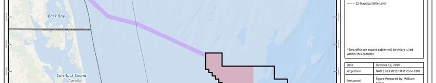
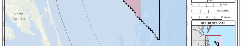
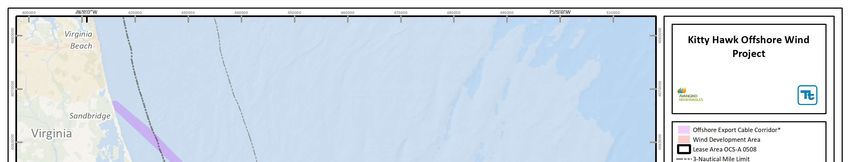
Kitty Hawk Offshore Wind Project Application to Request for the Incidental
 Harassment of Marine Mammals

1.0 DESCRIPTION OF SPECIFIED ACTIVITY
Kitty Hawk Wind, LLC (the Applicant), a wholly owned subsidiary of Avangrid Renewables, LLC, is
proposing to conduct marine site characterization surveys off the coast of North Carolina, as part of
the Kitty Hawk Offshore Wind Project (the Project) in the area of the Commercial Lease of Submerged
Lands for Renewable Energy Development on the Outer Continental Shelf (OCS; OCS-A 0508) (Lease),
and coastal waters where an offshore export cable corridor will be established (Figure 1). The
Applicant submits this request for Incidental Harassment Authorization (IHA) pursuant to Section
101(a)(5) of the Marine Mammal Protection Act (MMPA), and 50 Code of Federal Regulations § 216
Subpart I to allow for the incidental harassment of small numbers of marine mammals resulting from
the implementation of marine site characterization surveys. Specifically, surveys associated with the
operation of high-resolution geophysical (HRG) survey equipment during upcoming field activities.
Both the National Oceanic and Atmospheric Administration (NOAA) and the Bureau of Ocean Energy
Management (BOEM) have advised that sound-producing survey equipment operating below 200
kilohertz (kHz) (e.g., sub-bottom profilers) has the potential to cause acoustic harassment to marine
species in particular marine mammals. This request is being submitted to specifically address survey
sound-producing data acquisition equipment that operates below 200 kHz.

The regulations set forth in Section 101(a) (5) of the MMPA and 50 Code of Federal Regulations § 216
Subpart I allow for the incidental taking of marine mammals by a specific activity, if the activity is
found to have a negligible impact on the species or stock(s) of marine mammals, and will not result
in immitigable adverse impact on the availability of the marine mammal species or stock(s) for
certain subsistence uses. In order for the NOAA National Marine Fisheries Service (NOAA Fisheries)
to consider authorizing the taking by United States (U.S.) citizens of small numbers of marine
mammals, incidental to a specified activity (other than commercial fishing), or to make a finding that
incidental take is unlikely to occur, a written request must be submitted to the Assistant
Administrator. Such a request is detailed in the following sections.

1.1 Survey Activities
The Applicant has submitted to BOEM a Construction and Operations Plan to develop 40 percent of
the Lease Area in the northwest corner closest to shore (approximately 198 square kilometers[km 2]);
the Wind Development Area). The Applicant will conduct the 2021 HRG survey campaign in the
marine environment of the Wind Development Area and offshore export cable corridor. The Lease
Area is approximately 495 km2 and is located approximately 44 kilometers (km) offshore of Corolla,
North Carolina, in federal waters of the U.S. (see Figure 1). For the purpose of this Application, the
Survey Area is designated as the Wind Development Area (the northwestern 40 percent of the Lease
Area), and an approximately 62 km long by 2 km wide export cable corridor as noted in Figure 1.

 1
Kitty Hawk Offshore Wind Project Application to Request for the Incidental
 Harassment of Marine Mammals

Figure 1. Survey Area

 2
Kitty Hawk Offshore Wind Project Application to Request for the Incidental Harassment of Marine Mammals Water depths across the Wind Development Area range from approximately 27 to 38.5 meters (m). The offshore export cable corridor will extend from shallow water areas (0 m) near landfall to approximately 33 m depth. The purpose of the marine site characterization survey is to: Provide a more detailed understanding of the seabed and sub-surface conditions; Support the siting of the proposed wind turbine generators and offshore export cables; and, Meet the BOEM data quality guidelines for the HRG, archaeological, and benthic resources surveys. 1.1.1 HRG Survey High-resolution geophysical surveys under the purview of this Application are anticipated to commence no earlier than 01 Jun 2021 and finish in approximately 25 days, not including non-noise- generating days likely needed for weather down time. The survey equipment will be equivalent to the representative survey equipment identified in Table 1. The make and model of the listed HRG equipment may vary depending on availability, but will be finalized as part of the survey preparations and contract negotiations with the survey contractor. The surveys will cover approximately 3,300 linear kilometers in the Wind Development Area. During the surveys, the Fugro SPR EAH 2D Sparker will be used approximately 50 percent of the time, and assorted other equipment (outlined in Table 1) with frequency ranges above 200 kHz and outside of the hearing range of marine mammals or otherwise exempt for the remainder of the time. The Sparker data collection would follow initial collection using the other equipment, and thus would constitute no more than 50 percent of the survey effort. Surveys in the offshore export cable corridor will consist solely of the multibeam echo sounder, which has a frequency range above 200 kHz and outside of the hearing range of marine mammals. Thus, survey efforts in the offshore export cable corridor are excluded from the take request, as outlined in this Application, as impacts are not anticipated during this portion of the survey. The survey activities will be supported by a vessel capable of maintaining course and a survey speed of approximately 3 knots (5.6 kilometers per hour [km/hr]) while transiting survey lines. Surveys will be conducted along track lines spaced 300 m apart, with tie lines perpendicular to the main transect lines spaced 300 m apart. Given the very limited fleet of vessels that exists to service a growing number of projects along the U.S. East Coast, the number of vessels to be used is completely dependent on vessel availability during the proposed survey period, and the need to complete the survey in a timely manner. The Applicant desires the flexibility to (1) utilize vessels available during the survey period, and (2) have the ability to include additional vessels should the need arise, or as survey vessels become available. The Applicant understands the need to evaluate vessel transits associated with the proposed survey and anticipates up to three vessels may be necessary at a time. Concurrently operating vessels would remain at least 1 km apart. It is anticipated that during most of the survey only two vessels would be necessary, with one vessel operating nearshore and another operating offshore. However, final vessel choices will vary depending on the final survey design, vessel availability, and survey contractor selection. 3
Kitty Hawk Offshore Wind Project Application to Request for the Incidental
 Harassment of Marine Mammals

 Table 1. Measured Source Levels of Representative HRG Survey Equipment
 Operating Peak Source RMS Source Pulse Beam
 Representative HRG Signal
 HRG System Frequencies Level decibels Level dBRMS Duration Width
 Survey Equipment Type
 kilohertz (kHz) (dB)peak re 1 µPa re 1 µPa (ms) (degree)
 Subsea Positioning/ ultra-
 Sonardyne Ranger 2
 short baseline positioning 35-50 200 188 16 180 FM Chirp
 USBL
 system (USBL) a/

 Klein 3900 Side Scan 0.016 to
 Sidescan Sonar b/ 445 / 900 226 220 1 to 2 Impulse
 Sonar 0.100

 Parametric Shallow
 Innomar parametric
 penetration sub-bottom 85 to 115 247 241 c/ 0.07 to 2 1 FM Chirp
 SES-2000 Standard
 profiler

 Multibeam Echo Sounder b/ Reson T20-P 200/300/400 227 221 2 to 6 1.8 ±0.2 Impulse

 Fugro SPR EAH 2D 0.5 to 3
 Multi-level Stacked Sparker 0.4 to 3.5 223 d/ 213d/ 180 Impulse
 Sparker (700 J) d/

 a/ Based on previous conversations with NOAA Fisheries regarding USBL operations, potential harassment from operation of this device is not anticipated.
 b/ Operating frequencies are above all relevant marine mammal hearing thresholds and outside standard underwater test equipment measurement ranges.
 c/ The equipment specification sheets indicate a peak source level of 247 dB re 1 µPA m. The average difference between the peak and SPLRMS source levels for sub-
 bottom profilers measured by Crocker and Fratantonio (2016) was 6 dB. Therefore, the estimated SPLRMS sound level is 241 dB re 1 µPA m.
 d/ Sound levels where not available from the manufacturer. Therefore, the source levels and pulse duration are based on data from Crocker and Fratantonio (2016)
 using the Applied Acoustics Dura-Spark as a comparable proxy. The source levels are based on an energy level of 1,000 J with 240 tips and a bandwidth of 3.2 kHz.

 4
Kitty Hawk Offshore Wind Project Application to Request for the Incidental
 Harassment of Marine Mammals

To minimize cost, the duration of survey activities, and the period of potential impact on marine
species while surveying, the Applicant has proposed conducting continuous HRG survey operations
24 hours per day. Based on 24-hour operations, the estimated duration of the HRG survey activities
would be approximately 25 days, not including non-noise-generating days and weather down time.
Additional time may be required to obtain full multibeam coverage in shallow water areas, i.e.
offshore export cable corridor. Note that equipment that operates at frequencies above the hearing
threshold of marine mammals, i.e. above 200 kHz, is not further analyzed, and, therefore, not included
in the estimate of take calculations provided below. In addition, initial analysis revealed that the area
of possible disturbance for the Innomar would be insignificant (less than 0.5 m) and NOAA Fisheries
has determined that the Innomar is not a potential source of disturbance for marine mammals.
Therefore, takes are also not estimated or requested for Innomar operation.

1.2 Survey Activities Resulting in the Potential Incidental Taking of
 Marine Mammals
The potential effects of underwater noise resulting in takes on marine mammals are federally
managed by NOAA Fisheries, under the MMPA, to minimize the potential for both harm and
harassment. Under the MMPA, Level A harassment is statutorily defined as any act of pursuit,
torment, or annoyance that has the potential to injure a marine mammal or marine mammal stock in
the wild. However, the actionable sound pressure level is not identified in the statute. Level B
harassment is defined as any act of pursuit, torment, or annoyance that has the potential to disturb a
marine mammal or marine mammal stock in the wild by causing disruption of behavioral patterns,
including, but not limited to, migration, breathing, nursing, breeding, feeding, or sheltering.

In July of 2016, NOAA Fisheries finalized the Technical Guidance for Assessing the Effect of
Anthropogenic Sound on Marine Mammals - Underwater Acoustic Thresholds for Onset of Permanent
and Temporary Threshold Shifts (NOAA Fisheries 2016). Under this guidance, Level A harassment is
said to occur as a result of exposure to high noise levels and at the onset of permanent hearing
sensitivity loss, known as a permanent threshold shift (PTS). This revision to earlier NOAA Fisheries
guidelines is based on findings published by the Noise Criteria Group (Southall et al. 2007). For
transient and continuous sounds, it was concluded that the potential for injury is not just related to
the level of the underwater sound and the hearing bandwidth of the animal, but is also influenced by
the duration of exposure. The evaluation of the onset of PTS and temporary threshold shift (TTS)
provides additional species-specific insight on the potential for affect that is not captured by
evaluations completed using the previous NOAA Fisheries thresholds for Level A and Level B
harassment alone. The June 2018 Revision (NOAA Fisheries 2018b) to its 2016 Technical Guidance
largely reaffirmed these acoustic criteria.

Frequency weighting provides a sound level referenced to an animal’s hearing ability, either for
individual species or classes of species. Therefore, it is a measure of the potential of the sound to
cause an effect. The measure that is obtained represents the perceived level of the sound for that
animal. This is an important consideration, because even apparently loud underwater sound may not
affect an animal if it is at frequencies outside of the animal’s hearing range. In the NOAA Fisheries
final Guidance document, there are five hearing groups: Low-frequency (LF) cetaceans (baleen
whales), Mid-frequency (MF) cetaceans (dolphins, toothed whales, beaked whales, bottlenose
whales), High frequency (HF) cetaceans (true porpoises, Kogia, river dolphins, cephalorhynchid,

 5
Kitty Hawk Offshore Wind Project Application to Request for the Incidental
 Harassment of Marine Mammals

Lagenorhynchus cruciger and L. australis), Phocid pinnipeds (true seals), and Otariid pinnipeds (sea
lions and fur seals). It should be noted that Otariid pinnipeds do not occur in the Survey Area.

There are specific hearing criteria thresholds provided by NOAA Fisheries for each of these groups
(Table 2). These criteria apply hearing adjustment curves for each animal group known as M-
weighting.

 Table 2. M-Weighted PTS and TTS Acoustic Criteria and Metrics for Marine Mammals
 Functional Hearing PTS Onset Non- Functional Hearing
 PTS Onset Impulsive
 Group Impulsive Range
 219 dB peak &
 LF cetaceans 199 dB SELcum 7 Hz to 35 kHz
 183 dB SELcum
 230 dB peak &
 MF cetaceans 198 dB SELcum 150 Hz to 160 kHz
 185 dB SELcum
 202 dB peak &
 HF cetaceans 173 dB SELcum 275 Hz to 160 kHz
 155 dB SELcum
 218 dB peak &
 Phocid pinnipeds 201 dB SELcum 50 Hz to 86 kHz
 185 dB SELcum
 232 dB peak &
 Otariid pinnipeds a/ 219 dB SELcum 60 Hz to 39 kHz
 203 dB SELcum
 Sources: NOAA Fisheries 2016, 2018b
 SELcum: Cumulative sound exposure level
 a/ Do not occur in the Survey Area

NOAA Fisheries has defined the threshold level for Level B harassment at 120 dB RMS re 1 μPa for
continuous, non-impulsive noise and 160 dBRMS90% re 1 μPa for non-continuous, pulsed noise
(NOAA Fisheries 2016). The sound produced by the site investigation equipment may approach or
exceed ambient sound levels (i.e., level of existing noise in an area) and may approach or exceed their
zone of audibility, or the level of perception for marine mammals, defined as the range at which
animals may only just detect anthropogenic sound sources. However, actual perceptibility will be
dependent on a variety of factors, including the hearing thresholds of the species under consideration
and the inherent masking effects of ambient sound levels.

PTS criteria thresholds were assigned as prescribed in the Technical Guidance for Assessing the Effects
of Anthropogenic Sound on Marine Mammals (NOAA Fisheries 2016) and reaffirmed in the 2018
Revision to the Technical Guidance (NOAA Fisheries 2018b). NOAA Fisheries’ threshold level for Level
B harassment remains 160 dBRMS90% re 1 μPa.

2.0 DATES, DURATION, AND SPECIFIC GEOGRAPHIC REGION
2.1 Dates and Duration
HRG Surveys under the purview of this Application are anticipated to commence no earlier than 01
Jun 2021. The portion of the survey that utilizes sound under 200 kHz will take approximately 25
days, not including non-noise-generating days likely needed for weather down time. Therefore,
surveys would be restricted to the summer and fall seasons. Note that additional days will be needed

 6
Kitty Hawk Offshore Wind Project Application to Request for the Incidental
 Harassment of Marine Mammals

for activities utilizing survey equipment that operates above 200 kHz. This is not anticipated to result
in take, and is thus not included in this Application. This survey schedule is based on 24-hour
operations.

2.2 Specific Geographic Region
The Applicant’s survey activities will occur within the Wind Development Area (198 km 2 of the
approximately 495 km2 Lease Area) and along the offshore export cable corridor shown in Figure 1.

3.0 SPECIES AND NUMBERS OF MARINE MAMMALS
The Mid-Atlantic Environmental Assessment (EA) (BOEM 2012) reports 35 species of marine
mammals (whales, dolphins, porpoise, manatee, and seals) that may occur in the Northwest Atlantic
OCS region that are protected by the MMPA. Six of these are listed under the Endangered Species Act
(ESA) and are known to be present, at least seasonally, in the Lease Area (See Table 3). The North
Carolina EA (BOEM 2015) reports 16 species of marine mammals that may occur off the Virginia and
North Carolina coast that are protected by the MMPA. Five of these are listed under the ESA. A
description of the status and distribution of these species are discussed in detail in Section 4.0.

Table 3. Marine Mammals Known to Occur in the Marine Waters in Coastal Offshore
Virginia and North Carolina
 MMPA and ESA Estimated
 Common Name Scientific Name Stock a/
 Status Population
 Mysticetes (Baleen Whales)
 Balaenidae (Right and Bowhead Whales)
 North Atlantic Right MMPA: Strategic
 Eubalaena glacialis 428 W. North Atlantic
 Whale ESA: Endangered
 Balaenopteridae (Rorquals)
 Megaptera
 Humpback Whale MMPA: Non-Strategic 1,396 Gulf of Maine
 novaeangliae
 Balaenoptera MMPA: Strategic
 Fin Whale 7,418 W. North Atlantic
 physalus ESA: Endangered
 MMPA: Strategic
 Sei Whale Balaenoptera borealis 6,292 Nova Scotia
 ESA: Endangered
 Balaenoptera Canadian East
 Minke Whale MMPA: Non-Strategic 24,202
 acutorostrata Coast
 Balaenoptera MMPA: Strategic
 Blue Whale Unknown W. North Atlantic
 musculus ESA: Endangered
 Odontocetes (Toothed Whales)
 Delphinidae (Dolphins)
 Atlantic Spotted
 Stenella frontalis MMPA: Non-Strategic 39,921 W. North Atlantic
 Dolphin

 Risso’s Dolphin Grampus griseus MMPA: Non-Strategic 35,493 W. North Atlantic

 Long-Finned Pilot W. North
 Globicephala melas MMPA: Non-Strategic 39,215
 Whale Atlantic

 7
Kitty Hawk Offshore Wind Project Application to Request for the Incidental
 Harassment of Marine Mammals

Table 3. Marine Mammals Known to Occur in the Marine Waters in Coastal Offshore
Virginia and North Carolina (continued)
 MMPA and ESA Estimated
 Common Name Scientific Name Stock a/
 Status Population
 Short-Finned Pilot Globicephala W. North
 MMPA: Non-Strategic 28,924
 Whale macrorhynchus Atlantic
 Lagenorhynchus W. North
 White-Sided Dolphin MMPA: Non-Strategic 93,233
 acutus Atlantic
 White-beaked Lagenorhynchus W. North
 MMPA: Non-strategic 536,016
 dolphin albirostris Atlantic
 W. North
 Common Dolphin Delphinus delphis MMPA: Non-Strategic 172,825
 Atlantic
 W. North
 Atlantic,
 3,751 Southern
 Migratory
 Coastal
 Bottlenose Dolphin Tursiops truncatus MMPA: Non-Strategic W. North
 62,851 b/
 Atlantic Offshore
 N. North
 Carolina
 823
 Estuarine
 System
 W. North
 Clymene Dolphin Stenella clymene MMPA: Non-Strategic Unknown
 Atlantic
 Pan-Tropical Spotted W. North
 Stenella attenuata MMPA: Non-Strategic 6,593
 Dolphin Atlantic
 W. North
 Striped Dolphin Stenella coeruleoalba MMPA: Non-Strategic 67,036
 Atlantic
 W. North
 Spinner Dolphin Stenella longirostris MMPA: Non-Strategic Unknown
 Atlantic
 W. North
 Killer Whale Orcinus orca MMPA: Non-Strategic Unknown
 Atlantic
 W. North
 False Killer Whale Pseudorca crassidens MMPA: Strategic 1,791
 Atlantic
 Peponocephala W. North
 Melon-Headed whale MMPA: Non-Strategic Unknown
 electra Atlantic
 Physeter MMPA: Strategic
 Sperm Whale 4,349 North Atlantic
 macrocephalus ESA: Endangered
 W. North
 Dwarf Sperm Whale Kogia sima MMPA: Non-Strategic 7,750 c/
 Atlantic
 W. North
 Pygmy Sperm Whale Kogia breviceps MMPA: Non-Strategic 7,750 c/
 Atlantic
 Phocoenidae (Porpoises)
 Gulf of Main/Bay
 Harbor Porpoise Phocoena MMPA: Non-Strategic 95,543
 of Fundy

 8
Kitty Hawk Offshore Wind Project Application to Request for the Incidental
 Harassment of Marine Mammals

Table 3. Marine Mammals Known to Occur in the Marine Waters in Coastal Offshore
Virginia and North Carolina (continued)
 MMPA and ESA Estimated
 Common Name Scientific Name Stock a/
 Status Population
 Ziphiidae (Beaked Whales)
 Blainville’s Beaked Mesoplodon W. North
 MMPA: Non-Strategic 10,107 d/
 Whale densirostris Atlantic
 W. North
 True’s Beaked Whale Mesoplodon mirus MMPA: Non-Strategic 10,107 d/
 Atlantic
 Gervais’ Beaked Mesoplodon W. North
 MMPA: Non-Strategic 10,107 d/
 Whale europaeus Atlantic
 Cuvier’s Beaked W. North
 Ziphius cavirostris MMPA: Non-Strategic 5,744
 Whale Atlantic
 Sowerby’s Beaked W. North
 Mesoplodon bidens MMPA: Non-Strategic 10,107 d/
 Whale Atlantic
 Pinnipeds (Eared and Earless Seals)
 Phocidae (Earless Seals)
 W. North
 Harbor Seal Phoca vitulina MMPA: Non-Strategic 75,834
 Atlantic
 W. North
 Gray Seal Halichoerus grypus MMPA: Non-Strategic 27,131
 Atlantic
 Pagophilus W. North
 Harp Seal MMPA: Non-Strategic Unknown
 groenlandicus Atlantic
 W. North
 Hooded Seal Cystophora cristata MMPA: Non-Strategic Unknown
 Atlantic
 Sirenia (Sea Cows)
 Trichechidae (Manatees)
 MMPA: Strategic
 West Indian Manatee Trichechus manatus Unknown Florida
 ESA: Threatened
 Notes:
 a/ A strategic stock is defined as any marine mammal stock: 1) for which the level of direct human-caused mortality
 exceeds the potential biological removal level; 2) which is declining and likely to be listed as threatened under the ESA;
 or 3) which is listed as threatened or endangered under the ESA or as depleted under the MMPA (NOAA Fisheries
 2020a).
 b/ Estimates may include sightings of the coastal form.
 c/ This estimate includes both the dwarf and pygmy sperm whales.
 d/ This estimate includes Gervais’ beaked whales and Blainville’s beaked whales for the Gulf of Mexico stocks, and all
 species of Mesoplodon in the Atlantic.
 Sources: Hayes et al. 2020; Pace et al. 2017.

4.0 AFFECTED SPECIES STATUS AND DISTRIBUTION
As described in Section 3.0, there are up to 35 marine mammal species (whales, dolphins, porpoise,
manatee, and seals) which are known to be present (some year-round, and some seasonally or
incidentally) in the Mid-Atlantic OCS region. NOAA Fisheries uses Marine Species Density Data Gap

 9
Kitty Hawk Offshore Wind Project Application to Request for the Incidental
 Harassment of Marine Mammals

Assessments, developed by Roberts et al. (2018, 2020), which built upon models originally developed
by the U.S. Department of the Navy, to estimate marine mammal abundance (U.S. Navy 2007). The
current estimates provided by Roberts et al. (2018, 2020) are supplemented by data derived from
several sources and independent studies, and are used where feasible to update the species Stock
Assessment Reports (SAR) (et al. 2019). The Roberts et al. (2018, 2020) data suggests that marine
mammal density in the Mid-Atlantic region is patchy and seasonally variable. Currently, there are a
number of Unusual Mortality Events (UMEs) that NOAA Fisheries has evaluated and declared (NOAA
Fisheries 2020b), which include several of the species found in Virginia and North Carolina (minke
whale, North Atlantic right whale, humpback whale, bottlenose dolphin, manatee, and harbor or gray
seals). Of these, the most relevant for this Project are UMEs affecting the minke whale, right whale,
and humpback whale. While bottlenose dolphins are abundant in the Survey Area, the UME area of
effect does not currently overlap.

All 35 marine mammal species identified in Table 3 are protected by the MMPA and some are also
listed under the ESA. The six ESA listed marine mammal species known to be present year-round or
seasonally in the waters of the Mid-Atlantic are the sperm whale, right whale, fin whale, blue whale,
sei whale, and the West Indian manatee. The humpback whale stock that inhabits the Mid-Atlantic
region, and which may occur year-round, was recently delisted as an endangered species. Generally,
many of these species are migratory, and as such were historically thought to be present seasonally.
However, they are increasingly being seen will foraging throughout the summer and fall months and
in the winter during their migrations to warmer waters. Additionally, some individuals from the
larger whale species (including right whales) are known to remain year-round (Salisbury et al. 2018).
Dolphins, especially bottlenose, are known to be residents in Virginia coastal regions (Gubbins 2002).

The offshore waters of Virginia and North Carolina, including the Survey Area, are primarily used as
a migration corridor for these species, particularly by right whales, during seasonal movements
north or south between important feeding and breeding grounds (Firestone et al. 2008; Knowlton et
al. 2002). As of 26 Jan 2016, NOAA Fisheries expanded the North Atlantic Right Whale Critical Habitat
Southeastern U.S. Calving Area from Cape Fear, North Carolina, southward to 29°N latitude
(approximately 69 km north of Cape Canaveral, Florida). However, this expanded area is well south
of the proposed Survey Area. While the fin, humpback, sei, and right whales have the potential to
occur within the Survey Area, the sperm, and blue whales are more pelagic and/or northern species,
and their presence within the Survey Area is unlikely (Hayes et al. 2020). Aerial and vessel surveys
conducted in waters off Norfolk Canyon in Virginia observed sperm, blue, and sei whales in April
2018 along the edge of the continental shelf, as well as right, fin, and humpback whales closer inshore
(Cotter 2019). A juvenile blue whale sighting from a survey vessel was the first photographic record
of this species in the nearshore area (U.S. Navy Marine Species Monitoring 2018a). It may be that
prey availability, changing habitat from climate change, or other factors that are adjusting known
distributions are refining previous findings.

While the North Carolina EA (BOEM 2015) indicates that Bryde’s whale may be present during fall
and winter, the majority of sightings of this species have occurred within the northeastern Gulf of
Mexico (Waring et al. 2016). It is possible that the rare Bryde’s whale sightings off southeastern U.S.
states are strays from the Gulf of Mexico, and their presence in the Survey Area is unlikely during the
summer and fall (BOEM 2015). The West Indian manatee has been sighted in Virginia and North
Carolina waters. However, such events are infrequent. Because the potential for the sperm whale,

 10
Kitty Hawk Offshore Wind Project Application to Request for the Incidental
 Harassment of Marine Mammals

blue whale, Bryde’s whale, and West Indian manatee to occur within the Survey Area is unlikely, these
species will not be described further in this analysis. In addition, Atlantic white-sided dolphins are
most common in shelf waters from the Hudson Canyon north to Georges Bank, the Gulf of Maine, and
waters of the Gulf of St. Lawrence (Hayes et al. 2020). Therefore, any presence of Atlantic white-sided
dolphins in the Survey Area would be so rare as to be discounted, and they are not further addressed
in this analysis.

Historical strandings data for harbor and gray seals along the Mid-Atlantic Coast south of New Jersey
previously indicated their preference for colder, northern waters. Based on historical data, their
presence in the Survey Area was considered unlikely during the summer and fall (Hayes et al. 2020).
Winter haul-out sites for harbor seals have been identified within the Chesapeake Bay region and
Outer Banks beaches, however the seals are only occasionally sited as far south as the Carolinas and
are not likely to be present during spring and summer months during which survey activities are
planned (Hayes et al. 2020). More recent tagging and acoustic surveys in Virginia nearshore waters
spanning two years of study are providing updated baseline data, which indicate that seals utilize the
area more than previously thought. There is now regular seasonal occurrence of seals, including
harbor and gray, between fall and spring (U.S. Navy Marine Species Monitoring 2018b; Jones and
Dees 2020). Harbor seals are the predominantly observed seal species.

Until recently, coastal Virginia was thought to represent the southern extent of the habitat range for
gray seals, with few stranding records reported for Virginia and sightings occurring only during
winter months as far south as New Jersey (Waring et al. 2016). Similar to shifts in cetacean
occurrence, prey availability or changing habitat from climate change or other factors could be
driving changes in distribution of seals. More focused survey effort for seals, such as the one
presented in Jones and Dees (2020), are anticipated and may help refine and update previous
findings. Because harp and hooded seals are not anticipated to occur in the Survey Area, these species
will not be described further in this analysis. Gray seal distribution and status will not be further
described, but anticipated takes for this species will be included with harbor seals, as the current best
available data on predicted densities of seals (Roberts et al. 2018, 2020) does not distinguish
between harbor and gray seals. Rather, it provides a single density value for both species (due to low
detection rates the Roberts et al. [2018, 2020] model pools the species data).

The following subsections provide additional information on the biology, habitat use, abundance,
distribution, and the existing threats to the ESA-listed and MMPA-listed marine mammals that are
both common in both Virginia and North Carolina waters and have the likelihood of occurring, at
least seasonally, in the Survey Area. These species include the right whale, humpback whale, fin
whale, sei whale, minke whale, long-finned pilot whale, short-finned pilot whale, Atlantic spotted
dolphin, Risso’s dolphin, short-beaked common dolphin, bottlenose dolphin, and the harbor
porpoise. In general, the range of the remaining non-ESA listed cetacean species listed in Table 3 is
outside the Survey Area. These species are usually found in more pelagic shelf-break waters, have a
preference for northern latitudes, or are so rarely sighted that their presence in the Survey Area is
unlikely. Because the potential presence of these species in the Survey Area is considered extremely
low, they are not further addressed in this analysis.

 11
Kitty Hawk Offshore Wind Project Application to Request for the Incidental
 Harassment of Marine Mammals

4.1 Baleen Whales (Mysticetes)
4.1.1 North Atlantic Right Whale (Eubalaena glacialis) – Endangered
The North Atlantic right whale (right whale) is considered one of the most critically endangered
populations of large whales in the world and has been listed as a federal endangered species since
1970. The Western Atlantic stock is considered depleted under the MMPA (Hayes et al. 2020). There
is a recovery plan (NOAA Fisheries 2017) for the right whale and recently there was a five-year
review of the species (NOAA Fisheries 2017). The right whale has had a two percent recovery rate
since it was listed as a protected species (NOAA Fisheries 2017; Hayes et al. 2020). This is a drastic
difference from the stock found in the Southern Hemisphere, which has increased at a rate of seven
to eight percent (Knowlton and Kraus 2001).

Right whales are generally black (although some individuals have white patches on their undersides),
stocky build, lack a dorsal fin, a large head (about one quarter of the body length), strongly bowed
margin of the lower lip, and callosities on the head region. The tail is broad, deeply notched, and all
black with smooth trailing edge (Jefferson et al. 2015). Right whales are considered grazers as they
swim slowly with their mouths open. They are the slowest swimming whales and can only reach
speeds up to 8.6 knots (16 km/hr). They can dive at least 300 m and stay submerged for typically 10
to 15 minutes, feeding on their prey below the surface (Jefferson et al. 2015). The species’ prey is
primarily copepods (Calanus finmarchicus believed to be the primary prey) along with other
zooplankton including Centropages, Pseudocalanus, and cyprids (Mayo and Marx 1990). Right whale
hearing is in the LF range (Southall et al. 2007; NOAA Fisheries 2018c).

The right whale is a migratory large whale species that moves annually between high latitude feeding
grounds and low latitude calving and breeding grounds, though recent studies indicate not all of the
population undertakes seasonal migration (Davis et al. 2017). Right whales are nonetheless known
to have extensive movements both within and between their winter and summer habitats. The
present range of the western North Atlantic right whale population extends from the southeastern
U.S., which is utilized for wintering and calving, to summer feeding and nursery grounds between
New England and the Bay of Fundy and more recently the Gulf of St. Lawrence (Kenney 2002; Hayes
et al. 2020). Right whales may be found in feeding grounds within New England waters between
February and May, with peak abundance in late March (Hayes et al. 2020). The winter distribution of
right whales is largely unknown, although offshore surveys have reported detections annually in
northeastern Florida and southeastern Georgia (Hayes et al. 2020), and there was a winter sighting
in Jordan Basin in the Gulf of Maine which is speculated to be a potential winter mating ground
(Carpenter 2011). Their calving grounds are thought to extend from Florida to as far north as Cape
Fear, North Carolina (Hayes et al. 2020). A few events of right whale calving have been documented
from shallow coastal areas and bays (Kenney 2002).

The offshore waters of Virginia and North Carolina, including waters of the Survey Area, are used as
part of the migration corridor for right whales. Right whales occur here during seasonal movements
north or south between their feeding and breeding grounds (Firestone et al. 2008; Knowlton et al.
2002). Right whales have been observed in or near Virginia and North Carolina waters from October
through December, as well as in February and March, which coincides with the migratory time frame
for this species (Knowlton et al. 2002). They have been acoustically detected off Georgia and North
Carolina in seven of eleven months monitored (Hodge et al. 2015) and other recent passive acoustic

 12
Kitty Hawk Offshore Wind Project Application to Request for the Incidental
 Harassment of Marine Mammals

studies of right whales off the Virginia coast demonstrate their year-round presence in Virginia
(Salisbury et al. 2018), with increased detections in fall and late winter/ early spring. They are
typically most common in the spring (late March) when they are migrating north and, in the fall, (i.e.,
October and November) during their southbound migration (NOAA Fisheries 2017). There were
sightings of up to eight right whales on two separate days in coastal Virginia in April of last year (09
and 11 Apr 2018; Cotter 2019). Currently, there are no marine mammal sanctuaries in the waters off
Virginia pertaining to critical habitat for right whales (NOAA Fisheries 2017; Hayes et al. 2020). As
of 26 Jan 2016, NOAA Fisheries expanded the North Atlantic Right Whale Critical Habitat
Southeastern U.S. Calving Area from Cape Fear, North Carolina, southward to 29°N latitude
(approximately 69 km north of Cape Canaveral, Florida; Hayes et al. 2020). Based on the current
knowledge of right whale occurrences and the establishment of an SMA around approaches to
Chesapeake Bay, right whales have the potential to occur in the Survey Area, particularly during peak
migration times, and overall likelihood of occurrence in the Survey Area is rated as high.

Some evidence provided through acoustic monitoring suggests that not all individuals of the
population participate in annual migrations, with a continuous presence of right whales occupying
their entire habitat range throughout the year, particularly north of Cape Hatteras (Davis et al. 2017).
These data also recognize changes in population distribution throughout the right whale habitat
range that could be due to environmental or anthropogenic effects, a response to short-term changes
in the environment, or a longer-term shift in the right whale distribution cycle (Davis et al. 2017).

The best population estimate for right whales is 428 (Hayes et al. 2020). The right whale was the first
species targeted during commercial whaling operations and was the first species to be greatly
depleted as a result of whaling operations (Kenney 2009). Right whales were hunted until the early
twentieth century. Abundance estimates for the right whale population vary. From the 2003 U.S.
Atlantic and Gulf of Mexico Marine Mammal Stock Assessments, there were only 291 right whales in
existence, which is less than what was reported in the Northern Right Whale Recovery Plan written
in 1991 (NOAA Fisheries 2017; Waring et al. 2004). This is a tremendous difference from pre-
exploitation numbers, which are thought to be more than 1,000 individuals in the 1600s (Hayes et al.
2020).

When the right whale was finally protected in the 1930s, it is believed that the right whale population
was roughly 100 individuals (Waring et al. 2004). In 2015, the western North Atlantic population size
was estimated to be at least 476 individuals (Waring et al. 2016). That population size estimate
decreased to 451 individuals in 2018 (Hayes et al. 2020). Additional information provided by Pace et
al. (2017) confirms that the probability that the right whale population has declined since 2010 is
99.99 percent. Data indicates that the number of adult females dropped from 200 in 2010 down to
186 in 2015, while the number of males dropped from 283 to 272 in the same timeframe.

Also cause for concern is the confirmed mortality of numerous individuals. In June 2017, NOAA
Fisheries established an Unusual Mortality Event (UME) for right whales, which is still ongoing
(NOAA Fisheries 2020c). This UME for right whale strandings was declared in 2017 based on a high
number of dead whales discovered in Canadian and U.S. waters, and is still considered active, with
the current total whale strandings at 41 (NOAA Fisheries 2020c). Contemporary anthropogenic
threats to right whale populations, including fishery entanglements and vessel strikes, habitat loss,

 13
Kitty Hawk Offshore Wind Project Application to Request for the Incidental
 Harassment of Marine Mammals

pollution, anthropogenic noise, and intensive commercial fishing, may also negatively impact their
populations (Hayes et al. 2020; Kenney 2009).

Ship strikes of individuals can impact right whales on a population level due to the intrinsically small
remnant population that persists in the North Atlantic (Laist et al. 2001). For the period of 2012
through 2016, the minimum rate of annual human-caused mortality and serious injury to right
whales averaged 5.56 per year (Hayes et al. 2020). Records from 2012 through 2016 indicate there
have been seven mortalities and 19 serious injuries resulting from entanglement in fishing gear or
ship strikes (Hayes et al. 2020). From 2010 through 2014, the minimum rate of annual human-caused
mortality and serious injury to this species from fishing entanglements averaged 5.66 per year, while
ship strikes averaged 1.01 whales per year (Hayes et al. 2020). From 2012 through 2016, this rate
decreased slightly to an average 5.56 per year, while ship strikes also decreased to an average 0.41
right whales per year (Hayes et al. 2020).

Environmental fluctuations and anthropogenic disturbance may be contributing to a decline in
overall health of individual right whales that has been occurring for the last three decades (Rolland
et al. 2016). The most recent NOAA Fisheries marine mammal SAR states that the low annual
reproductive rate of right whales, coupled with small population size, suggests anthropogenic
mortality may have a greater impact on population growth rates for the species than for other whales,
and that any single mortality or serious injury can be considered significant (Hayes et al. 2020).

Most ship strikes are fatal to the right whales (Jensen and Silber 2004). Right whales have difficulty
maneuvering around boats and spend most of their time at the surface, feeding, resting, mating, and
nursing, increasing their vulnerability to collisions. Mariners should assume that right whales will
not move out of their way, nor will they be easy to detect from the bow of a ship, for they are dark in
color and maintain a low profile while swimming (World Wildlife Fund 2005). To address the
potential for ship strike, NOAA Fisheries designated the nearshore waters of the Mid-Atlantic Bight
as the Mid-Atlantic U.S. Seasonal Management Area (SMA) for right whales in December 2008. NOAA
Fisheries requires that all vessels 19.8 m or longer must travel at 10 knots (18.5 km/hr) or less within
the right whale SMA from 01 Nov through 30 Apr, when right whales are most likely to pass through
these waters (NOAA Fisheries 2018c). The most recent SAR noted that studies by van der Hoop et al.
(2015) have concluded that large whale vessel strike mortalities have decreased inside active SMAs
but have increased outside inactive SMAs, even with the implementation of Dynamic Management
Areas for right whales observed outside of an SMA (Hayes et al. 2020). The proposed Survey Area
has components located both within and outside of the right whale Chesapeake Bay SMA, located in
the waters off the southern Virginia coast (marking the mouth of the Chesapeake Bay). Other SMAs
in the region, but not within the proposed Survey Area, include the Delaware Bay SMA, Morehead
City SMA and the North Carolina-Georgia Coast SMA.

4.1.2 Humpback Whale (Megaptera novaeangliae) – Non-Endangered / Non-
 Strategic for West Indies Distinct Population Segment
The humpback whale was listed as endangered in 1970 due to population decrease resulting from
overharvesting (NOAA Fisheries 1991). A final recovery plan for the humpback whale was published
in 1991 (NOAA Fisheries 1991). In September 2016, NOAA Fisheries revised the listing and
identification of 14 distinct population segments for humpback whales (81 Federal Register 62259).
The Gulf of Maine stock is part of the West Indies distinct population segment, which is not ESA-listed

 14
Kitty Hawk Offshore Wind Project Application to Request for the Incidental
 Harassment of Marine Mammals

and is considered non-strategic under the MMPA (Bettridge et al. 2015; Hayes et al 2020); this stock
is the one most likely to be found within the Survey Area.

North Atlantic humpback whale body coloration is primarily dark gray, but individuals can have
variable amounts of white on their pectoral fins, flukes, and belly. Their tail variation is so distinctive
that the pigmentation pattern on the undersides of their flukes is used to identify individual whales
(Katona and Whitehead 1981). Humpback whales feed on small prey that is often found in large
concentrations, including krill and fish such as herring and sand lance (Bettridge et al. 2015).
Humpback whales are thought to feed mainly while migrating and in summer feeding areas; little
feeding is known to occur in their wintering grounds. Humpbacks consume roughly 95 percent small
schooling fish and five percent zooplankton (i.e., krill), and they will migrate throughout their
summer habitat to locate prey (Kenney and Winn 1986). They swim below the thermocline to pursue
their prey, so even though the surface temperatures might be warm, they are frequently swimming
in cold water (NOAA Fisheries 1991). Humpback whale hearing is in the LF range (NOAA Fisheries
2018b; Southall et al. 2007).

Humpback whales can occur within the Mid-Atlantic region during all seasons of the year (Hayes et
al. 2019). They exhibit consistent fidelity to feeding areas within the northern hemisphere (Stevick
et al. 2006). There are six subpopulations of humpback whales that feed in six different areas during
spring, summer, and fall. These feeding populations can be found in the Gulf of Maine, the Gulf of St.
Lawrence, Newfoundland/Labrador, western Greenland, Iceland, and Norway (Bettridge et al. 2015;
Hayes et al. 2020). During winter, humpback whales migrate to mate and calve primarily in the West
Indies (including the Antilles, the Dominican Republic, the Virgin Islands, and Puerto Rico), calving
the following year between January and March (NOAA Fisheries 1991; Blaylock et al. 1995, Bettridge
et al. 2015; Hayes et al. 2020). While migrating, humpback whales utilize the Mid-Atlantic as a
migration pathway between calving/mating grounds to the south and feeding grounds in the north
(Hayes et al. 2020). Not all humpback whales migrate to the Caribbean during winter, and some
individuals of this species, namely juveniles, are sighted in mid- to high-latitude areas during the
winter (Swingle et al. 1993). The Mid-Atlantic area may also serve as important habitat for juvenile
humpback whales, as evidenced by increased levels of juvenile strandings along the Virginia and
North Carolina coasts (Wiley and Asmutis 1995).

The humpback whale population within the North Atlantic has been estimated to include
approximately 1,396 individuals (Hayes et al. 2020). According to the species SAR, the best estimate
of abundance for the Gulf of Maine stock of humpback whales is, at a minimum, 896 individuals
(Hayes et al. 2020). Before whaling activities took place, it was thought that the abundance of whales
in the North Atlantic stock was in excess of 15,000 (Nowak 2002). By 1932, commercial hunting
within the North Atlantic may have reduced the humpback whale population to as little as 700
individuals (Breiwick et al. 1983). Humpback whales were commercially exploited by whalers
throughout their whole range until they were protected in the North Atlantic in 1955 by the
International Whaling Commission ban. Humpback whaling ended worldwide in 1966 (NatureServe
2020). Some whaling of humpback whales continued after the international ban in Greenland,
Iceland, and a few Caribbean islands. However, Iceland and the Caribbean islands have suspended
these activities, likely permanently. Contemporary threats to humpback whales include harmful algal
(red tide) blooms, fishery entanglements, and vessel strikes. These stressors could moderately
reduce the population size or growth rate of the West Indies distinct population segment (Bettridge

 15
You can also read