EAGLE Technical specifications for implementation of a new land-monitoring concept based on - D3: Draft design concept and CLC-Backbone, CLC-Core ...
←
→
Page content transcription
If your browser does not render page correctly, please read the page content below
EEA/IDM/R0/17/003

Technical specifications for implementation
of a new land-monitoring concept based on
                   EAGLE

D3: Draft design concept and CLC-Backbone,
CLC-Core technical specifications, including
           requirements review.

                    Version 3.0

                    10.11.2017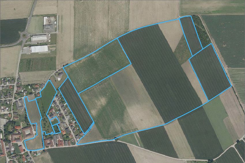
Version history

Version   Date         Author                      Status and                  Distribution
                                                   description
2.0       04/10/2017   S. Kleeschulte, G. Banko,   Draft for review by NRC     EEA, NRC LC
                       G. Smith, S. Arnold, J.     LC
                       Scholz, B. Kosztra, G.
                       Maucha

                       Reviewers:

                       G-H Strand, G. Hazeu, M.
                       Bock, M. Caetano, L.
                       Hallin-Pihlatie

3.0       10/11/2017   S. Kleeschulte, G. Banko,   Updated draft integrating   For distribution at Copernicus User
                       G. Smith, S. Arnold, J.     the comments following      Day
                       Scholz, B. Kosztra, G.      the NRC LC workshop
                       Maucha

                       Reviewers:

                       G-H Strand, G. Hazeu, M.
                       Bock, M. Caetano, L.
                       Hallin-Pihlatie

                                                                                                        1|Page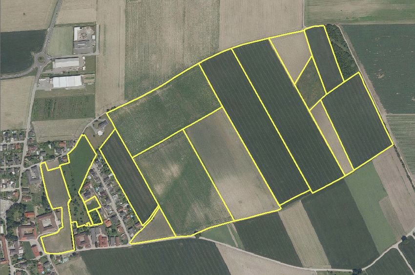
Table of Contents

1     Context ............................................................................................................................................ 6
2     Introduction .................................................................................................................................... 7
    2.1      Background ............................................................................................................................. 7
    2.2      Concept ................................................................................................................................... 8
    2.3      Role of industry ..................................................................................................................... 12
    2.4      Potential role of Member States........................................................................................... 12
    2.5      Engagement with stakeholder community ........................................................................... 13
3     Requirements analysis .................................................................................................................. 14
4     CLC-Backbone – the industry call for tender ................................................................................ 16
    4.1      Spatial scale / Minimum Mapping Unit ................................................................................ 18
    4.2      Reference year ...................................................................................................................... 18
    4.3      EO data .................................................................................................................................. 18
      4.3.1          Pre-processing of Sentinel-2 data ................................................................................. 19
    4.4      Copernicus and European ancillary data sets ....................................................................... 19
      4.4.1          Completeness OSM road data ...................................................................................... 25
    4.5      National data......................................................................................................................... 28
      4.5.1          Example: Rivers and lakes ............................................................................................. 28
      4.5.2          Example: roads .............................................................................................................. 29
      4.5.3          Example: land parcel identification system (LPIS) ........................................................ 29
    4.6      Specification for geometric delineation................................................................................ 30
      4.6.1          Level 1 Objects – hardbones ......................................................................................... 31
      4.6.2          Level 2 Objects – softbones .......................................................................................... 34
      4.6.3          Accuracy of geometric delineation: .............................................................................. 34
    4.7      Specification for thematic attribution .................................................................................. 34
      4.7.1          Thematic classes ........................................................................................................... 35
    4.8      Proposal for production methodology ................................................................................. 37
      4.8.1          Step 1: Definition and Selection of persistent boundaries ........................................... 38
      4.8.2          Step 2: Image segmentation ......................................................................................... 40
5     CLC-Core – the grid approach ....................................................................................................... 41
    5.1      Background ........................................................................................................................... 41
    5.2      Populating the database ....................................................................................................... 42
    5.3      Data modelling in CLC-Core .................................................................................................. 43
    5.4      Database implementation approach for CLC-Core ............................................................... 44

                                                                                                                                           2|Page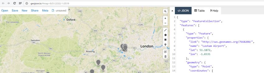
5.4.1         Database concepts revisited: from Relational to NoSQL and Triple Stores .................. 44
      5.4.2         CLC-Core Database: spatio-temporal Triple Store Approach ....................................... 49
      5.4.3         Processing and Publishing of CLC-Core Products .......................................................... 50
      5.4.4         Conclusion and critical remarks .................................................................................... 50
6     CLC+ - the long-term vision ........................................................................................................... 51
7     CLC-Legacy .................................................................................................................................... 54
    7.1      Experiences to be considered ............................................................................................... 55
8     Technical specifications ................................................................................................................ 58
    8.1      CLC-Backbone ....................................................................................................................... 58
    8.2      CLC-Core ................................................................................................................................ 61
9     Annex 1: OSM data ....................................................................................................................... 63
    9.1      Crosswalk between OSM land use tags and CLC nomenclature Level 2............................... 63
    9.2      OSM road nomenclature....................................................................................................... 64
    9.3      OSM roads – completeness .................................................................................................. 65
10        Annex 2: LPIS data in Europe .................................................................................................... 66
11        Annex 3: illustration of Step 1 “hardbone geometry” of CLC-Backbone .................................. 70
12        Annex 4: CLC-Backbone data model ......................................................................................... 72
      12.1.1        Integration of temporal dimension into LISA................................................................ 75
      12.1.2        Integration of multi-temporal observations into LISA .................................................. 76
13        Annex 5 – CLC nomenclature .................................................................................................... 78

                                                                                                                                        3|Page
List of Figures
Figure 2-1: Conceptual design for the products and stages required to deliver improved European
land monitoring (2nd generation CLC). .................................................................................................... 8
Figure 2-2: A scale versus format schematic for the current and proposed CLMS products. .............. 11
Figure 4-1: illustration of a merger of current local component layers covering (with overlaps) 26,3%
of EEA39 territory (legend: red – UA, yellow - N2K, blue – RZ LC) ....................................................... 16
Figure 4-2: Processing steps to derive (1) the geometric partition of objects on Level 1 using a-priori
information, (2) the delineation of objects on Level 2 using image segmentation techniques and (3)
the pixel-based classification of EAGLE land cover components and attribution of Level 2 objects
based on this classification ................................................................................................................... 17
Figure 4-3: Illustration of OSM completeness for Estonia (near Vändra), Portugal (near Pinhal Nova),
Romania (near Parta) and Serbia (near Indija) (top to bottom). © Bing/Google and EOX Senitnel-2
cloud free services as Background (left to right). ................................................................................. 27
Figure 4-4: Search result for the availability for national INSPIRE transport network (road) services
using the ELF interface (Nov. 2017). ..................................................................................................... 29
Figure 4-5: Overview of available GIS datasets LPIS and their thematic content © Synergise, project
LandSense. ............................................................................................................................................ 30
Figure 4-6: illustration of results of step 1 – delineation of Level 1 landscape objects. The border
defines the area for which Urban Atlas data is available (shaded) versus the area where not UA data
was available (not shaded). .................................................................................................................. 39
Figure 5-1: CLC with a 1 km raster/grid superimposed (top) illustrating the difference between
encoding a particular unit as raster pixel (centre) or a grid cell (bottom). “daa” is a Norwegian unit:
10 daa = 1 ha. ........................................................................................................................................ 42
Figure 5-2: Representation of real world data in the CLC-Core. ........................................................... 43
Figure 5-3: Example of an RDF triple (subject - predicate - object). ..................................................... 47
Figure 5-4: GeoSPARQL query for Airports near the City of London. ................................................... 48
Figure 5-5: Result of the GeoSPARQL of Figure 5-4 as map and in the JSON format. .......................... 48
Figure 5-6: Schematic view of the distributed SPARQL endpoints communicating with each other.
The arrows indicate the flow of information from a query directed to the French CLC SPARQL
endpoint. ............................................................................................................................................... 49
Figure 5-7: Intended generation of CLC+ products based on the distributed triplestore architecture.
.............................................................................................................................................................. 50
Figure 7-1: Generalisation technique applied in Norway based on expanding and subsequently
shrinking. The technique exists for polygon as well as raster data. ..................................................... 56
Figure 7-2: Generalization levels used in LISA generalization in Austria .............................................. 56
Figure 7-3: Examples of 25 ha, 10 ha and 1 ha MMU CLC for Germany ............................................... 56
Figure 7-4: Result of the generalisation process in Germany with technical changes in different
classes ................................................................................................................................................... 57
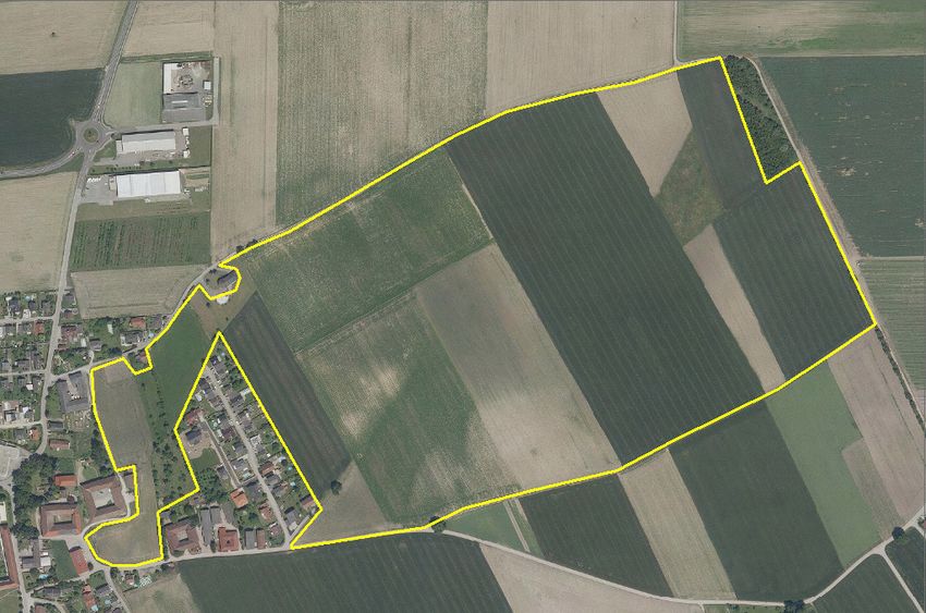
Figure 10-1: Illustration of (a) physical block, (b) field parcel and (c) single management unit68
Figure 10-2: Overview of available GIS datasets LPIS and their thematic content © Synergise, project
LandSense ............................................................................................................................................. 69
Figure 12-1: INSPIRE main feature types: land cover dataset and land cover unit .............................. 73
Figure 12-2: EAGLE extension to land cover unit and new feature type land cover component......... 73
Figure 12-3: The new CLC-Basis model (based on LISA) ....................................................................... 74
Figure 12-4: illustration of temporal NDVI profile and derived land cover components throughout a
vegetation season (Example taken from project Cadaster Env Austria, © Geoville 2017) .................. 76
4|Page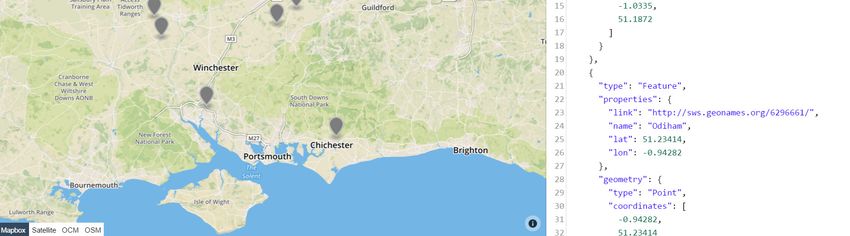
Figure 12-5: Draft sketch to illustrate the principles of the combined temporal information that is
stored in the data model ...................................................................................................................... 77

List of Tables
Table 2-1: Overview of key characteristics proposed for the four elements / products of the 2nd
generation CLC. ..................................................................................................................................... 10
Table 2-2: Summary (matrix) of potential roles associated with each element / product. ................. 13
Table 4-1: Overview of existing Copernicus land monitoring and other free and open products which
were analysed as potential input to support the construction of the geometric structure (Level 1
“hard bones”) of the CLC-Backbone. The products finally proposed for further processing are marked
in green. ................................................................................................................................................ 20
Table 4-2: Main characteristic of Level 1 objects (hardbone) and level 2 objects (softbones) ............ 31
Table 5-1: Comparison of selected Triplestores with respect to spatial and temporal data. .............. 47
Table 6-1: List of CLC classes and requirements for external information ........................................... 52

                                                                                                                                            5|Page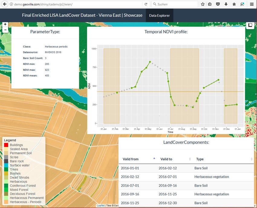
1 CONTEXT
The European Environment Agency (EEA) and European Commission DG Internal Market, Industry,
Entrepreneurship and SMEs (DG GROW) have determined to develop and design a conceptual
strategy and associated technical specifications for a new series of products within the Copernicus
Land Monitoring Service (CLMS) portfolio, which should meet the current and future requirements
for European Land Use Land Cover (LULC) monitoring. These products are nominally called the "2nd
generation CORINE Land Cover (CLC)".
After a call for tender in 2017, the EEA has tasked the EIONET Action Group on Land monitoring in
Europe (EAGLE Group) with developing an initial response to fulfilling these needs through a
conceptual design and technical specifications. The approach adopted represents a sequence of
development stages, where separate single elements of the whole concept could be developed
relatively independently and at different rates, to allow time for broad consultation with
stakeholders. This also allowed the inclusion of MS input, the exploitation of industrial production
capacity, and the necessary feedback, lessons learnt and refinement to reach the ultimate goal of a
coherent and harmonized European Land Monitoring Framework.

The first stage of this process outlined the conceptual strategy and proposed a draft technical
specification for the first product (CLC-Backbone) to be developed. The first stage also involved a
presentation of the concept to the EIONET NRCs Land Cover and the collection of the NRCs feedback,
which were then carefully taken into consideration for the continuation of the process into the
second stage. The first stage was undertaken within the constraints outlined by EEA and DG GROW
for the initial product:

    •   Industrial production by service providers,
    •   Outcome product in vector format,

    •   Highly automated production process,

    •   Short timeframe of production phase,

    •   Driven by Earth Observation (Sentinel-2),

    •   Complete the picture started by the Local Component1 products (EEA-39).
This document represents the second stage of development to further expand on the conceptual
strategy and to extend the current technical specifications, to propose additional follow-up products
in more detail and to continue to communicate these to the stakeholders involved in the field of
European land monitoring. This second stage also aims at enlarging the circle of stakeholders to all
interested Copernicus users and beyond. It is vital for the success of the project and the long-term
evolution of land monitoring in Europe that all the relevant stakeholders communicate their
requirements and opinions to this process.

Revised versions of this document are to continue to be produced at specific milestones towards a
final version in early 2018.

1
 The term “component” has a twofold function, 1) as the Copernicus local component products, 2) as a term
for Land Cover Component as an element within the EAGLE data model

                                                                                               6|Page
2 INTRODUCTION
This chapter provides the background to the concept, an outline of the proposed approach to be
adopted, an overview of the elements of the concept and the current status of the developments.

2.1 Background
Monitoring of Land Use and Land Cover (LULC) and their evolving nature is among the most
fundamental environmental survey efforts required to support policy development and effective
environmental management2. Information on LULC play a key role in a large number of European
environmental directives and regulations. Many current environmental issues are directly related to
the land surface, such as habitats, biodiversity, phenology and distribution of plant species,
ecosystem services, as well as other issues relevant to climate change. Human activities and
behaviour in space (living, working, education, supplying, recreation, mobility & communication,
socializing) have significant impacts on the environment through settlements, transportation and
industrial infrastructure, agriculture, forestry, exploitation of natural resources and tourism. The
land surface, who´s negative change of state can only – if at all – be reversed with huge efforts, is
therefore a crucial ecological factor, an essential economic resource, and a key societal determinant
for all spatially relevant basic functions of human existence and, not least, nations’ sense of identity.
Land thus plays a central role in all three factors of sustainable development: ecology, economy, and
society.

LULC products so far tend to be produced independently of each other at the global, European,
national and sub-national levels, each of them focussing on similar but still different emphasis of
thematic content. Such diversity leads to reduced interoperability and duplication of work, and
thereby, inefficient use of resources. At the European level CORINE Land Cover (CLC) is the flagship
programme for long-term land monitoring and is now part of the Copernicus Land Monitoring
Service (CLMS). CLC has been produced for reference years of 1990, 2000, 2006 and 2012, with 2018
under preparation and expected to be available by late 2018. The CLC specification aims to provide
consistent localized geographical information on LULC using 44 classes at level-3 in the
nomenclature (see Annex 5). The vector databases have a minimum mapping unit (MMU) of 25 ha
and minimum feature width (MFW) of 100 m with a single thematic class attribute per land parcel.
At the European level, the database is also made available on a 100 x 100 m and 250 x 250 m raster
which has been aggregated from the original vector data at 1:100 000 scale. CLC also includes a
change layer which records changes between two of the 44 thematic classes with a MMU of 5 ha.
Although CLC has become well established and has been successfully used, mainly at the pan-
European level, there are a number of deficiencies and limitations that restrict its wider exploitation,
particularly at the Member State (MS) level and below. This is partly due to the fact that many MS
have access to more detailed, precise and timely information from national programs, but also to
the fact that the MMU of CLC (25 ha) is too coarse to capture the fine details of the landscape at the
local and regional scales. In consequence, all features of smaller size that represent landscapes
diversity and complexity are not mapped either because of geometric generalization or because they
are absorbed by thematically mixed classes with very broad definitions. Moreover, changes of
features and landscape dynamics that are highly relevant to locally decided but globally effective
policy, such as small-scale forest rotation, changes in agricultural practices and urban in-filling, may
be missed due to low spatial resolution and/or thematic depth of CLC class definitions. The
successful use of CLC in combination with higher spatial resolution products to detect and document

2
    Harmonised European Land Monitoring - Findings and Recommendations of the HELM Project.

                                                                                              7|Page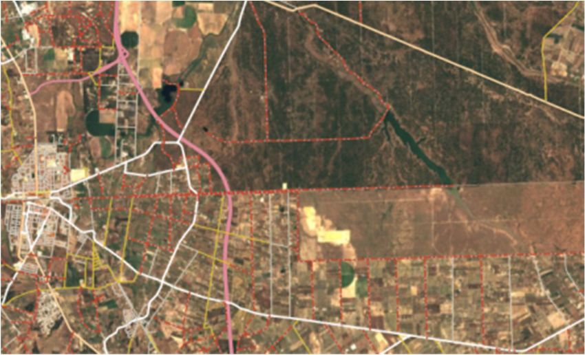
urban in-filling has given a clear indication of the required direction of development for European
land monitoring.
To address some of the above issues, the CLMS has expanded its portfolio of products beyond CLC to
include the High Resolution Layers (HRLs) and local component (LoCo) products. The HRLs provide
pan-European information on selected surface characteristics in a 20 m raster format, also available
aggregated to 100 m raster cells. They provide information on basic surface properties such as
imperviousness, tree cover density and permanent grassland and can be described as intermediate
products. The LoCo products in vector format are based in part on very high spatial resolution EO
data tailored to a specific landscape monitoring purpose (e.g. Urban Atlas), which provide detailed
thematic LCLU information on polygon level with a MMU in a range of 0.25 to 1 ha. However, the
LoCo products altogether do not provide wall to wall coverage of the EEA-39 countries, even when
combined. Their nomenclatures are not harmonised and thus cause interoperability problems.

2.2 Concept
Given the above issues a revised concept for European Land Monitoring is required which both
provides improved spatial and thematic performance and builds on the existing heritage. Also,
recent evolutions in the field of land monitoring (i.e. improved Earth Observation (EO) input data
due to e.g. Sentinel-programme, national bottom-up approaches, processing methods, additional
reporting requirements, INSPIRE directive, etc.) and desktop and cloud-computing capacities offer
opportunities to deliver these improvements effectively and efficiently. The EEA in conjunction with
DG GROW has identified this need and now aims to harmonise and integrate some of the CLMS
activities by investigating the concept and technical specifications for a higher performance pan-
European mapping product under the banner of "2nd generation CLC".
It was determined that such a 2nd generation CLC should build upon recent conceptual development
and expertise, while still guaranteeing backwards compatibility with the conventional CLC datasets.
Also, the proposed approach should be suitable to answer and assist the needs of recent evolution
in European policies like reporting obligations on land use, land use change and forestry (LULUCF),
plans for an upcoming Energy Union or long-term climate mitigation objectives. After a successful
establishment of 2nd generation CLC there would then also be knock-on benefits for a broad range of
other European policy requirements, land monitoring activities and reporting obligations.

The proposed conceptual strategy consists of a number of interlinked elements (Figure 2-1) which
stand for separate products and therefore can be delivered independently in separate stages. Each
of the products has its own technical specification and production methodology and can be
produced through its own funding / resourcing mechanisms. Throughout the documents delivered
by this project the conceptual design given in (Figure 2-1) will be used as a key graphic to identify the
product and stage being described.

Figure 2-1: Conceptual design for the products and stages required to deliver improved European
land monitoring (2nd generation CLC).

                                                                                             8|Page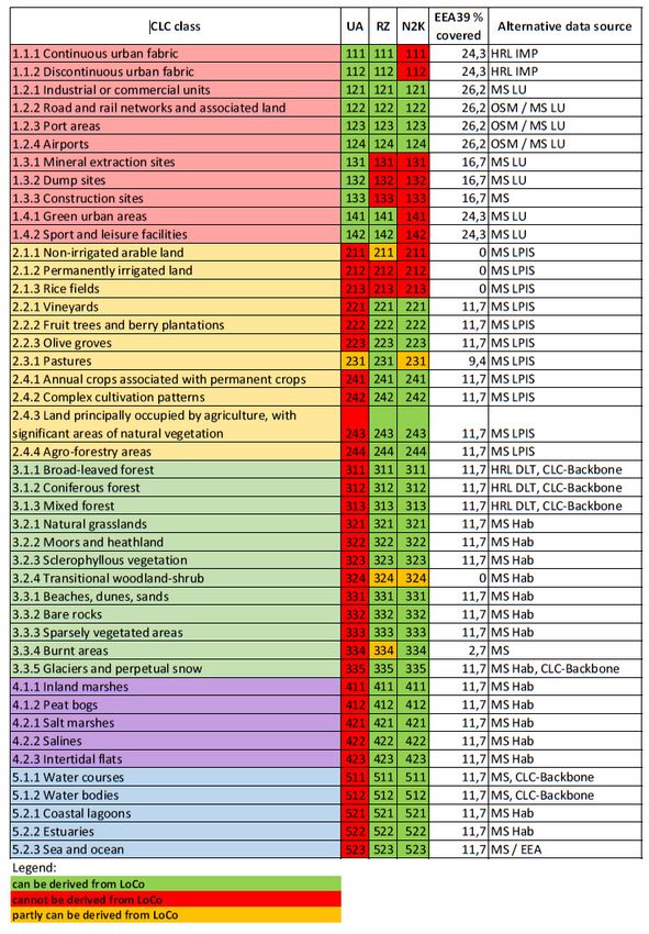
The structure of the conceptual design proposed by the EAGLE Group for the 2nd generation CLC is
based on the four elements shown in Figure 2-1. The reports associated with this work will expand
incrementally on the conceptual design and provide technical specifications of increasing
elaboration for the products. Although the four elements / products will be described in more detail
later in this, and subsequent, reports they can be summarised as follows:

    1. CLC-Backbone is a spatially detailed, large scale inventory in vector format providing a
       geometric spatial structure for landscape features with limited, but robust EO-based land
       cover thematic detail on which to build other products.
    2. CLC-Core is a consistent, multi-use grid3 database repository for environmental information
       populated with a broad range of land cover, land use and ancillary data, forming the
       information engine to deliver and support tailored thematic information requirements.
    3. CLC+ is the end point for this specific exercise and is a derived vector and raster product
       from the CLC-Core and CLC-Backbone and will be a LULC monitoring product with improved
       spatial and thematic performance, relative to the current CLC, for reporting and assessment.
    4. The final element of the conceptual design, although not strictly a new product, is the ability
       to continue producing the existing CLC, which may be referred to as CLC-Legacy in the
       future, which already has a well-established and agreed specification.
Table 2-1 provides a first overview of the main characteristics of the four elements that are
developed in more detail in the following chapters of this document. The table allows the reader to
make comparisons between the key characteristics of the products

3
 A data structure whose grid cells are linked to a data model that can be populated with the information from
the different sources.

                                                                                                 9|Page
Table 2-1: Overview of key characteristics proposed for the four elements / products of the 2nd
generation CLC.
CLC-Backbone CLC-Core CLC+ CLC-Legacy
Description Detailed wall to wall All-in-one data Thematically and A more generalised
(EEA-39) geometric container for land geometrically LULC product
vector reference layer monitoring detailed LULC consistent with the
with basic thematic information product. CLC specification.
content. according to EAGLE
data model.
Role / Support to CLMS Thematic Support to EU and Maintain the time
purpose products and services characterisation of national reporting series (backwards
at the pan-European CLMS products and and policy compatibility) and
and local levels. services at the pan- requirements. support legacy
European and local business systems.
levels.
Format Vector. GRID database. Raster and vector. Raster and vector.
ThematicFigure 2-2 is a schematic description of the conceptual design showing the relationship of the new
elements / products to existing CLMS products in terms of their format and level of spatial detail. In
this representation:
1. The current or conventional CLC (CLC2000, CLC2006, CLC2012, CLC2018 etc.), a polygon map
with fewer details.
2. The LoCos (Urban Atlas, Riparian Zones, N2000 etc.), polygon maps with more spatial and
thematic details.
3. The HRLs (Imperviousness, Forest, Grassland, Wetland etc.), raster products for specific
surface characteristics with high spatial details.
4. The proposed CLC-core, a grid product where the level of detail was still to be decided.
5. The CLC-Backbone and CLC+, both polygon maps with more details
Figure 2-2: A scale versus format schematic for the current and proposed CLMS products.
Given the context, requirements and issues, the aim should be to find a means to deliver the
concept and its proposed products with an efficient mixture of industrially produced material backed
up by auxiliary information from various national programmes. It is important to propose a viable
system in which there is flexibility to adapt the later steps to issues of feasibility and practicality once
the implemention of the earlier steps is underway. For instance, the outcomes of the CLC-Backbone
production should be able to influence thematic content of the CLC-Core and / or the technical
specifications of the CLC+.
11 | P a g e2.3 Role of industry
The development and production of CLC to this pointed has had only a limited role for industry,
mainly focused on the productions of pre-processed image datasets (e.g. IMAGE2006, IMAGE2012
etc.), the validation of the CLC2012 products and in some MS the subcontracting of the actual
production. Conversely, the production of the non-CLC products within the CLMS has been
dominated by industry through a series of service contracts to generate consistent products across
Europe.
Industry has the ability to produced operational solutions which exploit automation, can handle
large data volumes and are scalable to European-wide requirements. As the amount of available EO
and GI data increases, highly efficient and effective mechanisms for production will be required for
at least parts of the European land monitoring process and economies of scale must be exploited.
Industry therefore offers a number of capabilities which will be required at selected points within
the 2nd generation CLC.
DG GROW has expressed the wish that industry should have an initial role in the production of CLC-
Backbone which has therefore been designed in part to exploit industrial capabilities. Further
opportunities for industrial involvement are shown in Table 2-2.
2.4 Potential role of Member States
The MS have always been intimately linked with the CLC as its production has been the responsibility
of the nominated authorities through EIONET. The MS have provided the production teams for the
actual mapping to exploit local knowledge, familiarity with native landscape types and access to
national datasets which may not have been possible to share further. This bottom-up production
approach has been key to successful delivery of this important time series.
With respect to the non-CLC products within the CLMS the MS involvement has been limited so far
to verification and, in the case of the 2012 products, enhancement. Although the MS have provided
valuable feedback and enhancement in some cases, particularly on the HRLs, their capabilities have
not been fully exploited within the CLMS.
Table 2-2 shows the potential for a greater role for the MS across all of elements / products. It is
important that the MS experts have oversight of the specification, as is happening within this
project, and opportunities to contribute data, experience and location knowledge to the production
and validation activities where appropriate.
12 | P a g eTable 2-2: Summary (matrix) of potential roles associated with each element / product.
CLC-Backbone CLC-Core CLC+ CLC-Legacy
EEA / DG Definition, Definition, Definition, Definition,
GROW / EC coordination, coordination, main coordination, main coordination, main
main user. user. user. user.
MS Review of Review of Review of Production,
specification, specification, specification, validation, user.
validation, user. population with support to
national datasets, production,
user. validation, user.
Industry Production. Implementation Support Validation.
and maintenance production,
DB infrastructure. validation.
2.5 Engagement with stakeholder community
The success of the project and the long-term development of land monitoring in Europe is
intrinsically linked to the involvement of the stakeholder community. It is vital that all the relevant
stakeholders are aware of this activity and contribute their requirements and opinions to this
process. Revised versions of this document are foreseen at specific milestones towards a final
version for deliver in early 2018.
This specific deliverable, D3, is the second step towards the definition of the conceptual strategy and
the potential technical specifications for a series of new CLMS products. It aims at communicating
these details to the stakeholders involved in European land monitoring to elicit feedback, comments
and questions. The work reported here begins with a requirements review which goes beyond the
remit of the call for tender. The four elements and potential products of the 2nd generation CLC
within the CLMS are described in further detail in the following chapters. This version already
includes the first feedback from the NRC LC meeting in Copenhagen in October, 2017. For CLC-
Backbone, this document updates the draft versions of the technical specifications and the outline
implementation methodology provided in D2. These details are still open for discussion and able to
be reviewed by stakeholders and will ultimately be used as input for an open call for tenders to
industrial service providers for a production to start in 2018. For CLC-Core, this document provides a
more advanced outline of the technical specification and proposes a number of options for the
implementation. The technical design of CLC-Core will continue to be developed based on
stakeholder feedback in future steps. Similarly, the current thinking around CLC+ will continue to be
developed to illicit feedback to guide expansion of the technical specifications at a future step within
the project.
13 | P a g e3 REQUIREMENTS ANALYSIS
In line with the principle of Copernicus this analysis in support of the development of new products
with CLMS is driven by user needs rather than the current technical capabilities of EO sensors and
processing systems. The technical issues will be dealt with in the chapters related to the products
focusing on specification and methodological development. This analysis was initially based around
the requirements set out in the original call for tender, but this has now been extended through
inclusion of recent work by the EC and ETC to provide a broader range of stakeholder needs. As this
project develops further, requirements will be integrated to support the increasingly detailed
specifications towards those for a complete 2nd generation CLC.
Although the MMU and thematic issues of CLC have been extensively reported for some time, the
target specification for a future improved harmonised European land monitoring product are less
clear. The proposed products should support European policies, particularly assist reporting
obligations on European level (and not on national level) on land use, land use change and forestry
(LULUCF), plans for an upcoming Energy Union and long-term climate mitigation objectives.
However, many of the policies that could exploit EO-based land monitoring information rarely give a
clear quantitative requirement for spatial, temporal or thematic specifications. The higher-level
strategic policies, such as the EU Energy Union often refer to the monitoring of other activities such
as REDD+ and LULUCF. Where actual quantitative analysis and assessment takes place, they tend to
rely on the products currently available. For instance, LULUCF assessments in Europe (independently
from national reporting obligations) use CLC, while at the global scale they use Global Land Cover
2000 (GLC 2000) with a 1 km spatial resolution (or 100 ha MMU). Some of these initiatives have
explored the potential of improved monitoring performance, such as the use of SPOT4 imagery with
a 20 m spatial resolution to show land-use change between 2000 and 2010 for REDD+ reporting, but
until very recently it has not been practical for these types of monitoring to become operational
globally.
A more fruitful avenue for user requirements in support of the 2nd generation CLC is to consider the
initiatives which are now addressing habitats, biodiversity and ecosystem services. The EU
Biodiversity Strategy to 2020 was adopted the European Commission to halt the loss of biodiversity
and improve the state of Europe’s species, habitats, ecosystems and the services. It defines six major
targets with the second target focusing on maintaining and enhancing ecosystem services, and
restoring degraded ecosystems across the EU, in line with the global goal set in 2010. Within this
target, Action 5 is directed at improving knowledge of ecosystems and their services in the EU.
Member States, with the assistance of the Commission, will map and assess the state of ecosystems
and their services in their national territory, assess the economic value of such services, and
promote the integration of these values into accounting and reporting systems. The Mapping and
Assessment of Ecosystems and their Services (MAES) initiative is supporting the implementation of
Action 5 and, although much of the early work in this area on European level has used inputs such as
CLC, it is obvious that to fully address this action an improved approach is required especially for a
better characterisation of land, freshwater and coastal habitats, particularly in watershed and
landscape approaches. The spatial resolution at which ecosystems and services should be mapped
and assessed will vary depending on the context and the purpose for which the mapping/assessment
is carried out. However, information from a more detailed thematic characterisation and
classification and at higher spatial resolution are required which are compatible with the European-
wide classification and could be aggregated in a consistent manner if needed.
A first version of a European ecosystem map covering spatially explicit ecosystem types for land and
freshwater has been produced at 1 ha spatial resolution using CLC (100 m raster), the predecessor of
14 | P a g ethe HRL imperviousness with 20 m resolution, JRC forest layer with 25 m spatial resolution plus a
range of other ancillary datasets (e.g. ECRINS water bodies) using a wide variety of spatial
resolutions (from detailed Open Street Map data to 10 x 10 km grid data used in Article 17 reporting
of the Habitats Directive). It is clear that ecosystem mapping and assessment could more fully
exploit the recently available Copernicus Sentinel data and land products, and move down to a
higher spatial resolution.
The recent EC-funded NextSpace project collected user requirements for the next generation of
Sentinel satellites to be launched in the 2030 time horizon. These requirements were analysed on a
domain basis and from the land domain those requirements which were given a context of “land
cover (including vegetation)” were initially considered. This was extended so that related contexts
such as “glaciers, lakes, above-ground biomass, leaf area index and snow” were also considered. A
broad range of spatial resolutions were requested from sub 2.5 m to 10 km, but two thirds of the
collated requirements wanted data in the 10 – 30 m region. As would be expected the requested
MMUs were also broadly distributed, but with a preference for 0.5 to 5 ha, which represents field /
city block level for much of Europe. The temporal resolution / update frequency was dominated by
yearly revisions, although some users could accept 5 yearly updates and some wished for monthly
updates, although the reason was unclear. The users were less specific about the thematic detail
required and the few references given were to CLC, EUNIS, LCCS and “basic land cover”. The
preferred accuracy of the products was in the range 85 to 90%.
The European Topic Centre on Urban, Land and Soil systems (ETC/ULS) undertook a survey of
EIONET members involved with the CLMS and CLC production considering a range of topics in
advance of the 2018 activities. Some of the questions referred to the shortcomings of CLC and the
potential improvements that could be made towards a 2nd generation CLC product. As expected, it
was noted that some CLC classes cause problems because of their mixed nature and instances on the
ground that are sometimes complex and difficult to disentangle. It was suggested that this situation
could be improved by the use of a smaller MMU so that the mapped features have more
homogeneous characteristics. Also, a MMW reduction, particularly for highways, would allow linear
features to be represented more realistically. Of the 32 countries, who responded to the
questionnaire, 25 of them would support a finer spatial resolution, showing that there is, in general,
a national demand for high spatial resolution LULC data. The proposals ranged from 0.05 ha to
remaining at the current 25 ha, but the majority favoured 0.54 to 5 ha. Thematic refinement is also
supported by around one third of the respondents, who requested improved thematic detail,
separation of land cover from land use, splitting formerly mixed CLC classes and the addition of
further attributes to the spatial polygons.
From the requirements review so far and considering the requirements put forward by LULUCF, it is
suggested that the ultimate product of a 2nd generation product would have a MMU of 0.5 ha and be
based on EO data with a spatial resolution of between 10 and 20 m. The thematic content would be
a refinement of the current CLC nomenclature to cope with changing MMU, separation of land cover
and land use for the needs of ecosystem mapping and assessment. The temporal update could come
down from 6 years to 3 years in the short-term, and potentially to 1 year in the longer-term.
4
0.5 ha being required by LULUCF
15 | P a g e4 CLC-BACKBONE – THE INDUSTRY CALL FOR TENDER
CLC-Backbone has been conceived as a new high spatial resolution vector product. It represents a
baseline object delineation with the emphasis on geometric rather than thematic detail. The wall-to-
wall coverage of CLC-Backbone shall draw on, complete and amend the picture started by the LoCo
(appr. 1/3 of total area) of the current local component products (Urban Atlas, Riparian Zones and
Natura 2000) as are currently shown in Figure 4-1. It will be comprehensive and effectively complete
the coverage of the EU-28 as a minimum, but preferably the whole EEA-39.
Figure 4-1: illustration of a merger of current local component layers covering (with overlaps) 26,3%
of EEA39 territory (legend: red – UA, yellow - N2K, blue – RZ LC)
CLC-Backbone will initially be produced by a mostly automated, industrial approach, where
production can be separated into different levels, including different degrees and sequential order of
automation and human interaction (Figure 4-2). Within CLC-Backbone landscape objects are defined
as vector polygons and identified on different levels.
Step 1: The first level of object borders (skeleton) represent persistent objects (“hard bones”) in
the landscape (Step 1).
Step 2: On a second level a subdivision of the persistent landscape features (Level 1) will be
achieved through image segmentation (“soft bones”), based multi-temporal Sentinel data within a
defined observation period (resulting in Level 2 landscape features = polygons).
16 | P a g eStep 3: The output of CLC-Backbone – the delineated objects – represent spectrally and/or texturally
homogeneous features that are further characterised and attributed using the EAGLE land cover
component concept. The characterization of objects (segments) can be achieved using two options
• Attributing the segments using summary indicators based on a pixel-based classification of
fairly simple land cover classes (e.g. dominating class, percentage mixture of classes for each
segment)
• And / or attributing the segments based on spectral mean values of segments
Figure 4-2: Processing steps to derive (1) the geometric partition of objects on Level 1 using a-priori
information, (2) the delineation of objects on Level 2 using image segmentation techniques and (3)
the pixel-based classification of EAGLE land cover components and attribution of Level 2 objects
based on this classification
For implementation of CLC-Backbone the existing European land cover monitoring framework has to
be considered:
Heritage: The concept has to take into account the existing pan-European and local Copernicus
layers and the spatial and thematic representation of the landscape. The technical specifications
to be provided by this contract are therefore based on a thorough review of available and
feasible datasets and their geometry and thematic content.
Integration: CLC-Backbone will integrate selected geometric information from existing
Copernicus products at different steps within the process.
Sequence of production: Ideally, the production of CLC-Backbone and of the other Local
Component data sets would be arranged in a sequential order that CLC-Backbone can build and
17 | P a g eintegrate on the most updated Local Component data to achieve best consistency among the
layers.
Realistically, the production will need to make use of selected elements of the existing Local
Component layers and High Resolution Layers and of existing ancillary data that might be not
identical with the reference year of the production. The time lag between input data and production
reference year does not comprise a limiting factor. As the final delineation of polygons is achieved by
image segmentation (“soft bones”) of Sentinel-2 images of the actual reference year, any derivation
of the “hard bone” based geometry compared to the actual landscape structure (due to outdated
data) will be compensated by the image segmentation step. Considering an annual land cover
change of approx. 0,5% (on CLC spatial scale) the existing layers and dataset still be able to provide a
reliable input that is adapted by the image segmentation step.
4.1 Spatial scale / Minimum Mapping Unit
CLC-Backbone shall address landscape features with a predefined MMU of 0.5 ha and a minimum
mapping width (MMW) of 10m (these values are subject to the ongoing consultation process and
might be revised).
Each object (delineated polygon) in CLC-Backbone will be encoded according to a quite basic land
cover nomenclature (between 5-15 pure land cover classes, in line with EAGLE Land Cover
Components) and additionally characterized – depending on the user requirements - by a number of
attributes (e.g. NDVI time series) giving more detailed information about the land cover and their
dynamics inside the polygon.
4.2 Reference year
The production of CLC-Backbone shall generally make use of images from the year 2017/2018, i.e.
Sentinel-2 HR layer stack. It is suggested that the image stack covers one full vegetation season
ranging from 2017 to 2018, noting that the vegetation season in the south of Europe starts already
in October of the previous year.
4.3 EO data
The Sentinel-2 data for the production of CLC-Backbone will need to make use of all available
observations from the ESA service hubs to provide a multi-spectral, multi-date, 10-20 m spatial
resolution imagery as input. As the full satellite constellation of Sentinel (using 2A and 2B) will be
available operationally from late 2017 onwards, it is anticipated that last month of 2017 and full year
2018 is the first full vegetation period for a comprehensive multi-temporal coverage of Europe.
In case of availability of a full European-wide coverage of VHR data for 2018, its integration in the
processing chain should be considered.
The synergic use of Sentinel -1 (SAR) imagery shall be considered for enhancing the thematic
information, especially on thematic issues like soil properties (wetness), tillage and harvesting
activities. Recent studies on the use of merged optical-SAR imagery as well as SAR visual products
and the experiences in HRL production have confirmed their applicability for both semi-automated
and visual interpretation.
18 | P a g e4.3.1 Pre-processing of Sentinel-2 data
As Sentinel-2 is an optical system the average cloud coverage influences the number of observations
significantly. Nowadays scenes are not ordered anymore according to their average cloud coverage,
but all cloud free (and shadow-free) pixels of an image can be analysed. The constellation of both
Sentinel-2 satellites improves the revisiting time to 3-4 days on average in Europe, having a more
frequent coverage in the north according to the overlaps of the S-2 path-footprints.
Each scene has to be pre-processed to correct for atmospheric conditions. ESA has evaluated two
different types of atmospheric corrections software algorithm in order to produce a L2A product:
• Sen2Cor and
• Maja
The Sen2Cor algorithm identifies clouds and shadows in a singular scene-by-scene approach,
whereas Maja (combination of MACCS (CNES/CESBIO) and ATCOR) identifies clouds and shadows
according to the complete image stack over time.
ESA will decide until end 2017 which algorithm and which data processing will be implemented for
atmospheric correction. Current plans foresee to start atmospheric correction using MAJA in Europe
from 1/2018 onwards and to reassess the algorithms in 2019.
The cloud detection is an important element in the processing chain, but for northern countries the
typical cloud coverage may still be a very limiting factor. Therefore, either archive data from longer
periods or data from additional sensors (optical and radar) should be considered to fill gaps due to
cloud coverage.
4.4 Copernicus and European ancillary data sets
There are a number of potential input sources beyond EO image data that can be used in the
delineation of landscape objects. Table 4-1 shows the potential datasets that were analysed to form
the majority of the “hard bones” or persistent boundaries in the landscape. Only those data can be
considered that provide an adequate spatial resolution. Those data that are finally suggested to
contribute to CLC-Backbone are marked in green, whereas all other data will be used to attribute the
thematic content of the GRID-database in CLC-Core.
Geospatial data (especially on roads, rivers, buildings, LPIS and land cover/land use) are held on
national level in many cases in higher level of detail. Some of the European data might be
substituted by national data given that the criteria concerning technical and licensing issues as
described in chapter 0 are met.
Besides free and open data on European level also commercial data could be considered as input
e.g. street data (e.g. Navmart – HERE maps, etc.) or the TanDEM-X DEM for small woody features
and structure information for tree covered areas.
19 | P a g eTable 4-1: Overview of existing Copernicus land monitoring and other free and open products which were analysed as potential input to support the
construction of the geometric structure (Level 1 “hard bones”) of the CLC-Backbone. The products finally proposed for further processing are marked in
green.
product MMU Minimum Format Potential use for constructing basic Reference year
width geometry
Pan-European
CORINE Land Cover and 25 ha status layer 100 m Vector outlines of basic vegetation types in 2012, 6-year
accounting layers 5 ha change layer remote areas without roads and update cycle
settlement network
HRL imperviousness 20 m pixel (0,04 ha) - Raster 20 m HR satellite imagery 2015, 3-year
update cycle
HRL tree cover density 20 m pixel (0,04 ha) - Raster 2015, 3-year
update cycle
HRL forest types 0,5 ha - Raster Minimum crown cover 10% 2015, 3-year
update cycle
HLR Permanent water bodies 20 m - Raster 20 m HR satellite imagery 2015, 3-year
update cycle
European Settlement Map 10*10 m pixel (0,01 ha) - Raster JRC one-off scientific product: 2.5 m 2014, no update
(ESM) VHR imagery; scientific product foreseen
reference year 2012
GUF+ 10*10 m Raster S1 10m and Landsat 30m, GUF+ 2014-15
2018 will be based on S1/S2
HRL Small woody feature 0,002 ha (raster product) Linear Vector and Streamlining halted due to VHR 2015 2015
elements Raster (5m concerns
and 100m)
HRL phenology 10 m - Raster Only attribution in CLC-Core 2018, likely 3-
years
Local Components
Urban Atlas 0,25 ha – 1 ha 10 m Vector Delineation of roads as polygon
feature and outer border of
settlement structure (large cities)
20 | P a g eproduct MMU Minimum Format Potential use for constructing basic Reference year
width geometry
Riparian Zone 0,5 ha 10 m Vector Delineation of rivers and roads as
polygon feature.
N2K product 0,5 ha 10 m Vector
RPZ Green linear elements 0,05 ha – 0,5 ha < 10 m Vector Delineation of small woody
width vegetation elements
< 100 m
length
National products
Variety of products for land Aggregated data according to EAGLE irregular
cover, land use, population, data model
environmental variables
Accompanying/Ancillary
Layers
IACS/LPIS Varying from block to - Vector Freely available and accessible for 2017, Yearly
parcel level, depending on less than 1/3 of Europe. Increasing updates
national system availability from year-to-year due to
INSPIRE regulation. Varying thematic
content (from reference parcel only
to detailed crop types)
Open Street Map - roads n.d. Line Linear transportation network Up-to date; full
(centre lines) time history
Open Street Map – buildings n.d. Vector - Delineation of single buildings Up-to date; full
Polygon (polygons) time history
Open Street Map – land use TBD. Vector - Polygon selection of settlement Up-to date; full
Polygon areas and transportation time history
infrastructure according to OSM land
use tags http://osmlanduse.org
HERE maps (Navmart) n.d. Line Commercial layer to replace OSM or Regular updates
national road databse
21 | P a g eproduct MMU Minimum Format Potential use for constructing basic Reference year
width geometry
EU Hydro (Copernicus Line Geometric quality derived from VHR Tbd.
reference layer) images, very high location accuracy
WISE WFD – surface water Waterbodies as polygons Polygon + line Based on WFD2016 reporting (UK 6 years (next
bodies Waterbodyline as line and Slovenia only for viewing) update 2022)
geometry
European coastline Line Has been produced by Copernicus
for HRL production.
Crowd-sourced data (citizen n.a. Point Observations from citizens as Irregular
observatories) promoted through Horizon 2020
research initiatives (e.g. LandSense,
groundtruth 2.0)
22 | P a g eSelected classes of the local Component products, Urban Atlas, Riparian Zones, and Natura 2000,
obviously have valuable information to offer for the production of CLC-Backbone. The HRL layers will
be mainly used for populating CLC-Core and only as one exception as well in CLC-Backbone.
The usage of additional geospatial information for constructing Level 1 “hard bones” is based on the
following arguments:
• European landscape is a highly anthropogenic transformed landscape, where transport and
river networks (beside others) form the basic subdivision of landscape
• The location of transport and river networks are fairly known due to geospatial data on
national and/or European scale
• Many of the borders defined by transport and river networks can be identified as well as
features directly from Sentinel-2 images, but this identification is combined with partially
very high costs and lower accuracies
The geospatial datasets are used in the delineation of level 1 “hard bones” in two different forms:
• As linear networks that define the border of landscape objects (e.g. parcels that are
surrounded by roads and rivers)
• As polygons that define a-priori landscape objects (e.g. wide roads, wide rivers)
Concretely we suggest the following use of existing COPERNICUS and ancillary data for the
production of CLC-Backbone (i.e. mainly for the provision of geometric information) and CLC-Core
(i.e. thematic related information).
For more detailed information on the suggested production methodology, please refer to chapter
4.8.
• CLC-Backbone:
o Urban Atlas:
Use of outer delineation of linear transport infrastructure (class 122xx roads
and class 122) for Level 1 “hardbone” delineation
Use of outer delineation of water areas (class 50000 water) for Level 1
“hardbone” delineation
Use of outer delineation of cities as “persistent” segments (Level 1) for the
delineation of settlement areas (class 111xx continuous urban fabric, class
112xx continuous urban fabric, 11300 isolated structures and class 12100
industrial and commercial units).
o Riparian Zones:
Use of river delineation (class 911 interconnected water courses and 912
highly modified water courses and 913 separated water bodies) for Level 1
“hardbone” delineation.
Use of outer delineation of cities as “persistent” segments (Level 1) for the
delineation of settlement areas (class 1111 continuous urban fabric, class
1112 dense urban fabric, 1113 low density fabric, 1120 industrial and
commercial units).
23 | P a g eYou can also read