AQA Revision: Tectonic Activity
←
→
Page content transcription
If your browser does not render page correctly, please read the page content below
AQA Revision: Tectonic Activity
1. Why do we get volcanoes and earthquakes?
It is all to do with PLATE TECTONICS. This is a relatively new theory (only
really been around for 100 years and been universally accepted for the last
40-50 years) and it looks at the structure of the Earth and examines how
vast areas of rock or PLATES can move. To understand this theory you need
to have an idea of the structure of the Earth. The diagram on the right shows
this. The crust floats on the semi-molten rocks of the Mantle. The high
temperatures in the Mantle result in convection currents that enable the
crust to move.
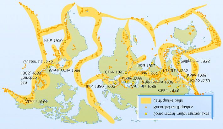
2. Is the Crust just one piece?
NO! It is split up into a series of
PLATES which fit together like a giant
jigsaw. The map on the left shows this-
note the underlying land masses in
blue. You can see that we are on the
Eurasian plate!
3. Are all these plates made of the
same material?
No! Some are made of continental
crust and some are made of oceanic crust. It is important to understand this as this will help you understand what
happens at the different plate boundaries. This table summarises the differences:
Data /
Oceanic crust Continental crust
Type
Crust deeper, average 40km, 75km beneath young
shallow, 5 - 12 km
depth mountain range
Age Young rocks, less than 200 Million years old Older, generally over 1500 Million years
2.6 x 10³ Kg m-3 NOT AS DENSE AS OCEANIC
Density 3.0 x 10³ Kg m -3 DENSE!
CRUST!
Rock
Range of granites with thin covering of
type, Mainly basalt
sedimentary rocks
geology
4. So what happens when the plates meet?
It depends! As I have already said it is determined by the type of crust involved, but also in terms of the direction in
which the plates are moving. The different types of plate boundary are discussed on the next page.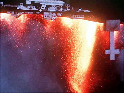
TIP: AT THIS POINT GO TO THE ‘s-cool’ SITE http://s-cool.co.uk/gcse/geography/tectonics/plate-boundaries.html

                                                            Destructive (Compressional) Plate Boundary (volcanoes &
                                                            earthquakes) - These cause violent volcanoes and
                                                            earthquakes, as well as deep-ocean trenches and fold
                                                            mountains. An oceanic plate and continental plate move
                                                            towards each other. The denser oceanic plate dives under
                                                            the lighter continental one, creating a deep ocean trench.
                                                            As the oceanic plate goes deeper into mantle it melts in the
                                                            subduction zone, due to friction and the increased
                                                            temperature. The newly molten rock is lighter that that
                                                            which surrounds it, so it will rise towards the surface and
                                                            cause volcanoes on the earth's surface. The continental
                                                            crust is crumpled by the collision of the two plates creating
Fold Mountains.

Constructive (Tensional) Plate Boundary (volcanoes- some
earthquakes) - Although often not as violent as those on
destructive plate boundaries, volcanoes and earthquakes do occur
on constructive plate boundaries. They also cause mid-ocean
ridges to form. Two plates move away from each other. Molten
rock (magma) rises from the mantle to fill the gap between the two
plates. This forms a mid-ocean ridge . Volcanoes can also form here,
along the edges of the plate boundary, due to the rising magma.
These volcanoes are called shield volcanoes.

Conservative Plate Boundary – (no volcanoes, but severe earthquakes)

                                         The main effects of a conservative plate boundary are earthquakes, which can
                                         be fairly violent and frequent. Two plates slide past each other, without
                                         creating or destroying any land. As they move past each other they often get
                                         stuck, building up great pressure until finally they jolt past each other. This
                                         sudden movement is what causes earthquakes.

                                         The best-known example of a
                                         conservative plate boundary
is the San Andreas Fault, where the North American and Pacific plates
are actually moving in the same direction, but at a different speed.

Collision (Compressional) Plate Boundary - (no volcanoes, but
frequent earthquakes)

Where two continental crusts collide neither can sink. Instead they
push into each other forcing material to be folded up into huge
mountain ranges. Often this movement and pressure can cause
earthquakes, but no volcanoes will occur on these boundaries.

The best example is found where the Indian plate collided with the
Eurasian plate to form the Himalayas.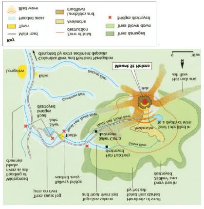
5. What landforms are created at the plate boundaries? This is
      concerned with FOLD MOUNTAINS and VOLCANOES.

   6. What are Fold Mountains?

   •   Fold mountains are formed along plate boundaries.
   •   Over millions of years, thick sediments were deposited in huge
       depressions called geosynclines.
   •   Rivers carried sediments and deposited them into the depressions. The
       sediments were compressed into solid sedimentary rocks such as
       sandstone and limestone.
   •   The plates moved together, forcing the rocks to fold upwards into fold
       mountains.
   •   There are found at DESTRUCTIVE MARGINS (e.g. the Andes mountains)
       and at COLLISION MARGINS (e.g. the Himalayas).

   7. What are the features of Fold Mountains and how are they used?

                                  Where there are upfolds these are called anticlines and downfolds are called
                                  synclines.

                                  These can be seen along the South Downs and the Weal d etc in England (Portsdown
                                  Hill and Butser Hill are examples of Anticlines formed at the same time as the Alps!) .

                                  Where the folds are really severely folded or faulted impressive mountain ranges like
                                  the Alps are formed.

                                  In fact, you should use the Alps as the example of how humans can use ‘Young Fold
                                  Mountains’. Some of these are as follows: -

   •   Tourism: e.g. Chamonix, where tourists were attracted to the area to ski, climb, walk as well as people who
       simply wanted to enjoy the scenery

   •   Hydro-electric power: The narrow, steep sided valleys and fast flowing rivers are ideal or HEP.
   •   Industry: The trees that grow are felled and the timber is used for fuel, building materials and for the production
       of paper. Heavy industry is not really an option due to the lack of space on the narrow valley floor.
   •   Farming: Dairy farming and some crops on the valley floor can be grown. Transhumance is the seasonal
       movement of people with their livestock over relatively short distances, typically to higher pastures in summer
       and to lower valleys in winter.

    8. What are volcanoes and where are they found?
Volcanoes are created where magma escapes through a
vent, which is a crack in the Earth’s crust.

Volcanoes are found at Destructive (Compressional) and
Constructive (Tensional) plate boundaries.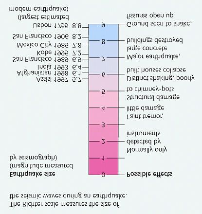
As has already been mentioned,
                                                                                          volcanoes can be created at
                                                                                          Constructive (Tensional) plate
                                                                                          boundaries, which is shown on
                                                                                          the diagram on the left and at
                                                                                          Destructive      (compressional)
                                                                                          plate boundaries which is shown
                                                                                          in the diagram on the right.

                                                                                          However, the characteristics of
                                                                                          the volcano differ depending on
                                                                                          where they are found due to the
                                                                                          character of the lava present.
                                                                                          Lava that has a low silica content
                                                                                          is described as ‘BASIC’, whereas
                                                                                          lava which is rich in silica is
described as ‘ACIDIC’. The different types of volcanoes are shown below. The one on the right has BASIC lava and the
one on the left has ‘ACID’ lava. Note the difference in shape- the Shield volcano (basic lava) is wide and flat because the
lava travels long distances (it is runny because it has less silica content) before it cools. The lava pours out frequently
which means that pressure doesn’t build up and consequently the eruptions are not explosive. Composite volcanoes are
steeper and are also made of ash as well as lava. Due to the high silica content, the lava is more sticky and the eruptions
tend to be explosive (e.g. Mount Saint Helens).

     9. What are the volcanic threats?

These can be split into primary and secondary effects. In fcat, the same can be said for the effetcs of earthquakes

1.   Primary effects- i.e. things that happen directly as a result of the eruption in the short term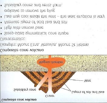
2. Secondary effects- i.e. things that happen as a result of the eruption. These may not be instantaneous and the
   effects may actually be felt in the much longer term

    Can you work out which of the following are primary and which are secondary effects?

    •   The volcanic blast- power of the blast can blow things over- this happened at Mount Saint
        Helens, where all the trees near the volcano were flattened.
    •   Pyroclastic flows - occur where the ash cloud that has been ejected into the air loses its
        ability to stay suspended and comes falling back to earth. This resultant clouds of searing hot
        ash and gases (often 600°C) rush down the sides of the mountain (often in valleys) at great
        speeds.
    •   Lava flows - Lava clearly is a hazard due to its ability to destroy most things in its path. However, lava flows can
        be diverted (Heimaey, 1973 in Iceland) and people are normally able to get out of the way!
    •   Volcanic Bombs- large boulders and stones (pumice) that is hurled out of the volcano during an eruption
    •   Lahars/Mudlfows - Mudflows and lahars are closely associated with volcanic activity. Rain brings soot and ash
        back to the ground, which becomes a heavily saturated mudflow when combined with melted snow and ice
        (perhaps from the peak of the volcano). The sediment that is picked up turns into the hazardous mudflow.

    10. Case Studies of Volcanic Activity - The two covered here are the ones most likely to have been taught to you.

    A. Mount Saint Helens, 1980 – An eruption in a MEDC

Where? NW USA in the Cascades mountain range

When? 18/5/1980 - 8:32 a.m.

Why? Caused by the subduction of the oceanic Juan de Fuca plate under the continental North American plate, on the
West Coast of the United States

What happened?

•   After minor earthquakes and a small
    eruption during March, scientists carefully
    monitored the mountain. By the beginning of
    May a bulge had developed on the North
    side of the mountain. Many people were
    evacuated.
•   An earthquake caused the bulge to collapse
    down the side of the mountain. This released
    the full power of the explosive gases behind
    as the mountain literally blew its own side
    off.
•   The explosions from the side of the
    mountain sent a speeding cloud of gas,
    steam and dust across the ground to the
    North of the volcano, flattening everything in
    its path.
•   The trees of the forests around the mountain
    were toppled as if they were matchsticks,
    with the majority of them facing in the same
    direction.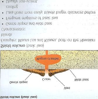
•   These explosions also instantly melted all of the snow on the mountain, adding to the mudflows that were racing
    down the mountain and into the rivers. These flows took all with them, including huge trees and even bridges. The
    mountain managed to reduce its height by nearly 400 metres and blew an amphitheatre shape hole in its side, 3km
    long and 500 metres wide.
•   61 people were killed by the eruption, mainly by the poisonous gases, but also by being caught up in the massively
    swollen rivers.
•   No wildlife, either plants or trees, survived within the 25km blast zone. However vegetation has already made great
    strides to re-colonise the area.
    EXAMINE THE DIAGRAM FOR MORE INFORMATION.

    B. Montserrat – An eruption in a LEDC

                           Montserrat is a small island is situated in
                           the Caribbean and 12 miles long and 7 miles
                           wide. Much of the population are poor and rely
                           on farming which is for their subsistence.
                           Before the eruption of 1995, over 12,000
                           people lived on the island but less than 5000 do
                           today.

                           The Soufriere Hills volcano started erupting in
                           1995 for the first time in 350 years. A month later 50 % of the population was evacuated to
                           the North of the island away from the danger/exclusion zone. The capital, Plymouth, became
                           a ghost town. Other effects included:

    Ø   2/3 of the island was covered in ash
    Ø   50% of the population were evacuated to the north of the island to live in makeshift shelters
    Ø   23 people died in 1997
    Ø   Floods as valleys were blocked with ash
    Ø   The airport and port were closed
    Ø   Farmland was destroyed
    Ø   Forest fires caused by pyroclastic flows
    Ø   Many schools and hospitals were destroyed

    And in the more medium to longer term:

    Ø As most of the southern area was destroyed any remaining inhabitants have had to endure harsh living
      conditions in the North.
    Ø Transport remains a problem for people travelling to the island as the port and airport remain closed.
    Ø The tourist industry is still suffering with few visitors except for cruise ships looking at the volcano
    Ø Over half the population left the island and have not returned

The response:

    ü £41 million in aid offered to help rebuild the island and £10.5 million to relocate refugees
    ü In 1997, £2400 was offered to each adult wanting to leave the island- there were riots though as the people
      wanted £20,000!
    ü The MVO (Montserrat Volcano Observatory) was set up to study the volcano and provide warnings for the
      future
11. What are Earthquakes and
        where are they found? -
        Earthquakes occur along
        faults, which are large
        cracks in the earth's crust.
        Most     of      these     are
        associated with the larger
        plate boundaries, along
        which        the       largest
        earthquakes usually occur.
        They are caused by the
        sudden jerking movements
        of the fault, either laterally
        or vertically, and are
        almost     impossible       to

        predict.

12. What key terms will I need to know?
Focus-The actual place where the fracture within the earth’s crust takes
place

Epicentre-The point on the earth’s surface directly above the focus- the
worst place to be in an earthquake!

Seismic Waves-The waves/energy that is produced in an earthquake

    13. How are earthquakes measured?
 They are measured on the Richer Scale. What is special about it? - A
scale of magnitude (strength and size of it)- it is special as it is a
logarithmic scale. This means that each point on the scale is x10 more
powerful than the previous point.
Earthquakes can also be measured on the Mercalli scale. This is a visual
obervation of the damage caused by the earthquake and is not relaint on
measuring the magnitude (strength) of the earthquake with scientific
instruments.

    14. What are the effects of Earthquakes?

v Primary effects – (All occur due to the shaking of the ground) include:
      o buildings collapsing
      o roads and bridges being destroyed
      o railway lines being buckled

v Secondary effects - are the subsequent effects of the earthquake, and can be
  even more devastating then the primary ones.

        o Fires: usually from ruptured gas lines. This was the main cause of
          death and damage after the San Francisco earthquake in 1906.
        o Tsunami: They can travel very quickly across entire oceans, before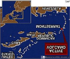
engulfing land 1000's of miles away. I’m sure you all witnessed
          the footage of the Indian Ocean Tsunami on 26/12/2004.
        o Landslides can often be triggered by earthquakes, causing huge
          amounts of material to be moved very quickly. This is actually
          what occurred just before the volcanic eruption on Mt. St.
          Helens. They are most likely to occur where the land is steep,
          saturated or weak.
        o Diseases can spread very quickly in the unsanitary conditions
          often left behind by massive earthquakes. Water becomes
          contaminated very quickly, and in Less Economically Developed
          Countries (LEDCs) especially; access for the medical services can be badly hampered by the damage caused
          by the quake. The most common diseases to be associated with earthquakes are therefore water-borne
          ones like cholera and typhoid.

    15. What Earthquake Case Study can be used?

Case Study – Kobe Earthquake 17/1/1995

When? - The earthquake occurred at 5.46am on the 17th January 1995. It measured 7.2 on the Richter Scale and lasted
20 seconds.

Where and Why? - Kobe lies on the Nojima fault in Japan, on a destructive boundary, where the Philippine plate dives
below the Eurasian plate.

Kobe was unlucky in the sense that the focus of the earthquake was very close to the surface and the epicentre was
right beside the city.

Effects?

Primary effects included a death toll of approximately 5,500, with another 30,000 injured and 250,000 made homeless.
Over 100,000 buildings collapsed. Infrastructure damage included a 1km stretch of elevated road, numerous railway
bridges, and 120 of the city’s 150 quays were damaged (for ships).

Secondary effects included the fact that electricity, gas, water and sewage systems were all hugely disrupted.
Emergency services found it very difficult to get into the city due to the massive destruction of the roads. Many
temporary shelters were required, as well as food and medicines. Cold weather meant that diseases spread quickly.

A week after the earthquake fires were still burning, 2 million homes still were without power and 1 million were
without water. The fires destroyed over 7,000 more homes. Hundreds of aftershocks, 74 strong enough for people to
feel, meant people were too afraid to return to their homes for weeks after the event.

Response? - Tough new laws, building codes and emergency plans were brought in after criticism of the Japanese
Government. Work is continuing to try to predict future earthquakes, but as yet there is very little way of giving any
significant warning time. In the short term, emergency aid and shelters were provided, but the scale of the disaster was
so large that the authorities struggled to cope.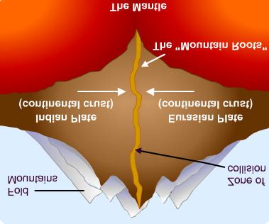
16. Can earthquakes and Volcanoes be predicted?

Volcanoes are easier to predict than earthquakes!

Volcano Prediction:

C Laser beams- these detect movement. Spray paint on the ground
  can also show ground deformation.
C Earthquakes- magma rising to the surface cracks rocks as it moves
  upwards and this creates seismic waves. These can be monitored
  and the pattern produced can suggest an eruption is imminent.
C Volcanic gases- scientists can measure co2 and other gases such as
  sulphur to see if there are in changes

Earthquake prediction - not as easy as it is ‘less visual’:

C Laser Detection- a laser is fired across a fault and it can detect even the smallest movements.
C Animal behaviour- animals often appear to have a ‘6th Sense ’. Often strange behaviour can suggest that an
  earthquake is imminent.
C Recurrence intervals- if an earthquake has not occurred along a fault line, then analysis of historical records can be
  used to determine whether one is due.
C Seismometers- Sensitive recording equipment can be used to record earth movements. A pattern may emerge that
  suggest that a serious event may occur.

   17. What are the differences in terms of response between LEDCs and MEDCs?
The things discussed above can be quite expensive and can put LEDCs at a disadvantage in tersm of preparedness.
However, there are alo differences in terms of responses too:

•   LEDCs do not have the technology to predict the tectonic
    threat as well as MEDCs.

•   LEDCs do not have the money to build for earthquakes.
    Often settlements are unplanned and the buildings have
    no control over them. LEDCs can not afford the ‘retrofit’
    of older buildings to make them earthquake proof like in
    MEDCs.

•   LEDCs do not have the ability to cope effectively with a
    tectonic event. The do not have the money to provide
    extensive emergency services or the resources to repair
    damage quickly.

•   LEDCs may rely on aid, which means that the response may not be as quick as it could/ should be.

•   LEDCs do not have the money to reconstruct in the long term.

    18. Are there differences between Rural and Urban areas?

•   The first thing to think about is that there is probably more to lose in urban areas (and MEDCs for that matter) in
    terms of financial values of properties etc. than in rural areas.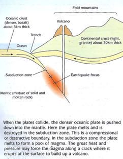
•   However, rural areas ( particularly in LEDCs) tend to be very remote, so that in the event of an earthquake/ volcanic
    eruption these areas could potentially suffer more. Emergency service provision will not be as good and the time
    taken for search/ rescue etc will take much longer.

•   The effects of an earthquake/ volcanic eruption may not become clear immediately and this could hinder the
    response.

•   Clearly, the things that have been discussed above are probably more likely to be a problem in LEDCs, but they still
    could be the case in MEDCs too.

•   Often LEDCs rely on aid after a volcanic eruption/ earthquake- this takes time, especially if the area affected by the
    event is in a rural area.

    19. Given all the problems that have been discussed, why do people live in these tectonically active areas?

Much of this is to do with the values and attitudes of people. Many have grown up with the hazard and their perception
is that they can cope with it and not fear it. I wouldn’t agree, but there are some good reasons why people live in such
areas:

•   Good soil- Lava and ash breaks down to provide fertile soil. In Sicily (Mount Etna) grapes are grown and in Japan and
    Java rice is grown

•   Tourists are attracted by the thought of walking up volcanoes, but also experiencing geysers, fumaroles and mud
    pools are popular!

•   Geothermal power- in Iceland the Geothermal heat is used to heat greenhouses (as well as 70% of homes) - I visited
    a greenhouse where the farmer was growing peppers and tomatoes-something normally done in Spain!

•   Valuable materials- Copper, gold, silver and lead are found in extinct volcanoes. Basalt is used to make roads and
    sulphur is mined

•   Fossil Fuels- plate movement can cause vegetation to get buried (coal) and other creatures can get buried (gas and
    oil) - things that we use for our energy needs!

BUT

They have to live with all the things that have been discussed in these pages. There are other things too that can be
triggered by tectonic movements such as rock falls, avalanches and mudslides that haven’t been discussed!
You can also read