Coastlines at Risk of Giant Earthquakes - Their Mega-Tsunami
←
→
Page content transcription
If your browser does not render page correctly, please read the page content below
Coastlines at Risk
of Giant Earthquakes
& Their Mega-Tsunami

By Robert Muir-Wood, Chief Research Officer

RMS has researched the potential risk posed by giant earthquakes (>M8.8) and their associated
tsunami. The comprehensive study examined the record of giant earthquakes to produce a global catalog
of giant earthquakes from 1550 to 2015. Subduction zones globally were examined to understand all
potential sources for M9 events, particularly on subduction zones that have not produced such high
magnitude events in history. In addition, RMS developed the RMS® Global Tsunami Scenario Catalog,
providing the most comprehensive global coverage of potential tsunami events on all major subduction
zones worldwide to highlight where these catastrophic events can occur and the multiple coastlines that
could be impacted.

Executive Summary

The March 11, 2011 moment magnitude (M) 9.0 Great East Japan Earthquake and Tsunami (also
known as the Tohoku Earthquake and Tsunami) was a surprise to many, including in the Japanese
earthquake science communities. An earthquake of this magnitude was not anticipated by Japanese
earthquake hazard models, which were based on historical seismicity and projected a M7.7-8.2
maximum potential earthquake for segments of the Japan Trench subduction zone off northeast Japan.
Sea walls built to ‘protect’ the complex of coastal nuclear power plants at Fukushima were designed for
an anticipated 5 meter tsunami, consistent with the lower maximum magnitudes assumed, not the 15-20
meter tsunami experienced.

The misinterpretation in the upper limit of maximum earthquake magnitudes in northeast Japan invites
many questions around where else similar “unexpected” giant earthquakes and accompanying tsunami
can occur. The answer is that many subduction zones worldwide may have the potential to generate
magnitude 9 events and their accompanying mega-tsunami. For many regions, this potential is not yet
fully acknowledged.

RMS has created a comprehensive historical catalog of giant earthquakes. This catalog shows that such
events happen on average about five times each century. About one third of subduction zone plate
boundaries are known to have experienced a giant earthquake and accompanying tsunami in the
historical record. That leaves two thirds of subduction zones that could potentially generate such events.
Based on the relative plate convergence and amount of interface coupling at these subduction zones, it is
possible to estimate the mean recurrence interval (and hence mean rate of occurrence) for such events
along each subduction zone. In turning these mean estimates into current rates we need to adjust them
according to whether specific subduction zones have already generated giant earthquakes over the past
few centuries.

While the shaking impact of giant earthquakes typically affects coastlines that run parallel with the
offshore subduction zone, the accompanying tsunami can cause substantial damage to coastal
communities a thousand kilometers or more from the source. The larger the earthquake, the greater the
proportion of the total damage that can originate from the tsunami. This report focuses on this tsunami
hazard from giant earthquakes.

1
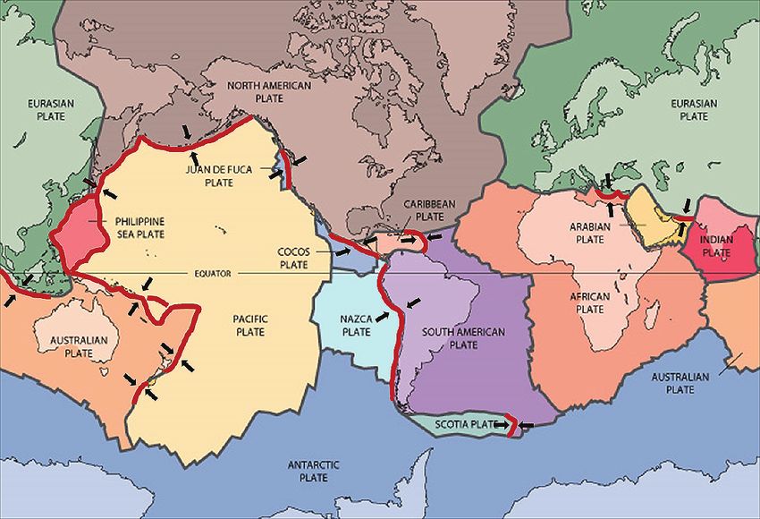
M9.0 Earthquakes are Significant Risk Drivers

The potential impact of an earthquake is primarily a function of its size. There is an approximately x30
difference in earthquake energy release over one unit on the magnitude scale: e.g., a M8.0 earthquake
releases 30 times as much energy as a M7.0 earthquake. The largest instrumentally recorded
earthquake, in southern Chile in 1960, had a moment magnitude assessed as M9.6.

The 2004 Indian Ocean earthquake and the 2011 Tohoku Japan earthquake highlight alternative area
versus displacement combinations. The 2004 earthquake had the longest fault rupture ever known,
extending for 1,200 km, and an area in excess of 100,000 km2 . In contrast, the 2011 Japan earthquake
had the smallest known rupture area for a M9.0 earthquake (of around 40,000 km2 ), whereas the fault
displacement was the largest ever known at between 40-50 meters. One measure of the potential impact
of an earthquake concerns the area over which strong ground motions are produced. Other measures
such as the duration of the shaking or the frequency content of the shaking can also influence the
potential impact.

The majority of the world’s subduction zones are situated around the edge of the Pacific Ocean, known
as the Ring of Fire, so named because of the large number of volcanoes formed above zones where the
Pacific seafloor is slowly being subducted beneath the surrounding continental plates and island arcs. A
band of subduction zones also extends around the south and west coasts of Indonesia, passing along the
west coast of Myanmar into the Himalayan arc, where the continental crust of India is subducted to the
north beneath Asia. Sections of subduction zone can be traced through southern Iran and the eastern
Mediterranean. A subduction zone also underlies the eastern Caribbean, and another lies beneath the
Scotia Arc at the southern extent of the Atlantic Ocean.

Map of the Earth’s Major Plate Boundaries. Subduction zones highlighted in red with
black arrows showing the direction of convergence. Base map source: USGS.

2
Giant earthquakes cause a multitude of impacts

Earthquake generation involves the sudden release of shear strain, accumulated over centuries in the
region surrounding the subduction zone fault, and its reconfiguration during the earthquake into
permanent fault displacement. This process has two principal manifestations: i) the ground motions
generated by the rupture itself and ii) the land level changes above the fault displacement.

Damage from Shaking
The area over which strong ground shaking is experienced will be a function of the overall spatial extent
of the fault rupture. For a typical configuration in which the plate boundary runs parallel to a coastline (as
along the western coast of South America) strong ground shaking will be experienced throughout the
coastal region parallel with the fault rupture and for a distance of 100 km or more inland.

As the plate boundary megathrust dips down beneath the adjacent coastline, the severity of the
amplitudes of the on-land strong ground motions are typically unremarkable, for the reason that even a
coastal town will be 40-50 km away from the down-dip extent of the fault rupture. This contrasts with
situations where earthquakes occur on shallow crustal fault ruptures passing directly alongside or
beneath a city, at distances of only 5-10 km, as at Northridge, California in 1994, Kobe, Japan in 1995 or
Port-au-Prince, Haiti in 2010. However, there have been situations where the long-period vibrations from
a subduction zone earthquake have become amplified due to resonance in an underlying sedimentary
basin, proving highly damaging to taller buildings at some distance from the subduction zone (e.g., 1985
Mexico City at more than 250 km).

Damage from Fault Displacement
A giant earthquake is also associated with
significant land-level changes in response to the
release of the stress formerly stored in the crust as
this is converted into fault displacement.

The dipping subduction zone emerges at the
seafloor as a deep ocean trench, formed where the
oceanic crust begins to downwarp beneath the
overriding plate. Inland but close to the trench in a
                                                             2004 Earthquake (and Tsunami): M9.0 earthquake
sudden episode of fault rupture, the upward                  1200 km fault rupture. Displacement up to 20 m

movement of the overriding plate raises the
seafloor by several meters over a zone that may be
100 km wide but entirely underwater. The downward movement of the underlying oceanic plate has the
effect of lowering the seafloor closer to land. This creates a zone of subsidence that can also include the
edge of the land itself, as happened in the 2011 Great East Japan Earthquake and Tsunami, when coastal
villages subsided by as much as 1 meter.

These land level changes happen so fast that they raise or lower the overlying sea surface. This in turn
triggers tsunami waves that move at great speeds in the deep ocean, but rise up and slow as the water
shallows, so that they can be 10-20 meters high at the coast. The period of the tsunami wave is very long,
so that high or low water can be sustained for ten minutes or more.

3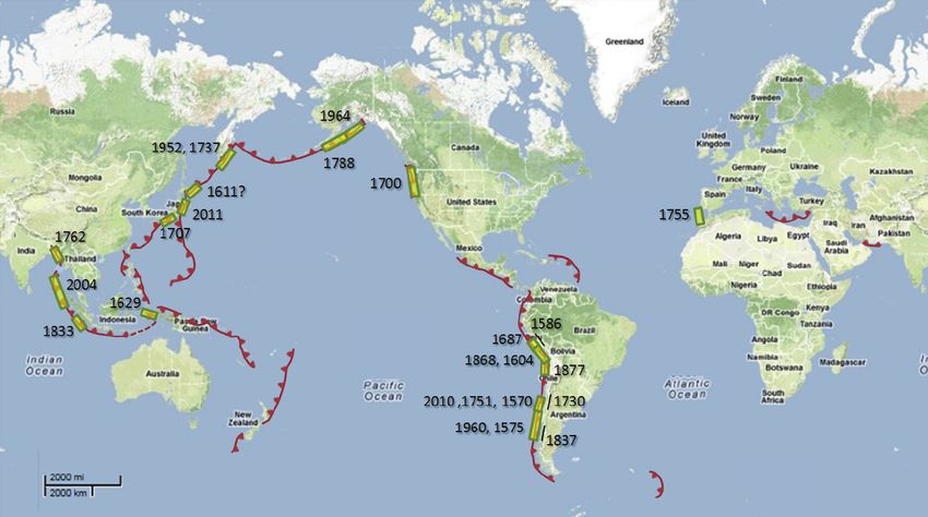
Tsunami: the Deadly Weapon of M9 Earthquakes

A larger earthquake can create strong ground shaking over a larger area, and the resulting earthquake
damage will generally be more extensive for a given increase in magnitude. In contrast, as the size of the
earthquake increases the destructive impacts of basin-wide tsunami become ever more significant,
destructive, and far reaching, capable of devastating low lying buildings on coastlines more than 1,000 km
away from the earthquake source. For the largest of all earthquakes, the tsunami can cause a very
significant component of the total damage.

                                                                For these subduction zone earthquakes the initial
    0     0.25   0.5km                                          movement of the sea observed at the coast is
                                                                generally one of withdrawal as water moves towards
                                                                the area where the seafloor has been lowered
                                                                offshore. Typically this is followed (within 10-20
                                                                minutes) by a rise in sea level radiating from the
                                               Inundation
                                               Depth (m)        area of raised seafloor located further offshore. The
                                                     >9.0
                                                     6.0-9.0
                                                     4.5-6.0
                                                                drop in water level thereby provides a warning that
                                                                a rise will follow. Throughout history people have
                                                     3.0-4.5
                                                     1.5-3.0
                                                     0.0-1.5

                                                                perished as they walked out to collect fish stranded
                                                                on the exposed coastline, unaware of the massive
    Lanarca Oil Refinery in Cyprus, located 30 meters from the   wave that is on its way.
    coastline, could experience a maximum inundation depth
    of 4.5 – 6.0 meters from a M9-generated tsunami off the
    Cyprus Arc. Source: RMS Global Tsunami Scenario Catalog
                                                                Beyond a threshold that may be 3-4 meters above
                                                                normal sea levels the tsunami begins to exceed the
                                                                height reached by extreme tides, waves or storm
                                                                surges and therefore may cause significant damage
                                                                to buildings located just above sea level. In addition
                                                                changes in land levels (i.e., uplift or subsidence) on
                                                                the neighboring coastline will impact the extent of
                                                                inundation.

                                                                The 2004 Indian Ocean tsunami was notable not only
                                                                for reaching >30 meters height along the adjacent
                                                                west coast of northern Sumatra, but also for the
                                                                degree to which tsunami elevations at regional
                                                                distances were polarized. The originating fault was
                                                                oriented North-South, propagating the tsunami most
                                                                strongly to the east and west, reaching 5-10 meters
                                                                heights along the coasts of Thailand and Sri Lanka,
                                                                1,000-2,000 km from the source, causing significant
                                                                coastal destruction and loss of life, far beyond where
                                                                the earthquake was felt. However in directions
    Olangapo in the Philippines could experience a maximum      parallel to the fault, there was no significant impact
    inundation depth of 9.0 meters from a M9.0-generated
    tsunami off the Manila Trench. Source: RMS Global Tsunami    of the tsunami to the north such as along the
    Scenario Catalog
                                                                low-lying delta coast of Bangladesh.

4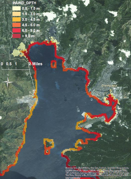
To understand the impact of tsunami, it is useful to consider three distance ranges. ’Near-field’ includes
coastlines within 500 km of the subduction zone, ‘medium field’ ranges out to 2,000 km, while ’far-field’ can
include shorelines on the other side of an ocean.

The speed at which the tsunami wave propagates is a function of the water depth. The tsunami waves
involve the whole water column, from the seafloor to the ocean surface. In the deep ocean, speeds can
reach up to 800 km/hour. In the deep ocean, a tsunami may have a wavelength of 500 km, but an amplitude
of only tens of centimeters, so small that a ship would not notice it. The tsunami wave slows as
the water shallows close to the coast, and the wave height increases.

Along the near-field coastline inland of a subduction zone, a tsunami typically arrives within 10-30 minutes.
The first incoming wave is not necessarily the most damaging. In the 2010 Maule Chile Tsunami, for example,
the second and third incoming waves were more damaging than the first. Tsunami waves undergo complex
refraction and reflection according to the underlying bathymetry and coastal topography. Along complex
coastlines, waves will show local variability in height and may becoming amplified in funnel-shaped estuaries.

The propagation of tsunami over very long distances means that tsunami can cause damage in otherwise
sheltered harbors and estuaries on the other side of an ocean. In Japan there are detailed written records of
almost every tsunami observed on the coasts of Honshu for at least 400 years, including all the largest
tsunami originating on the other side of the Pacific. The height of the tsunami in Japan provides a useful
measure of the potential size and extent of historical tsunami sources in South America, going back
hundreds of years before instrumental measurements of earthquake magnitude.

Giant Earthquakes – Where can They Occur?
Before 1900 and the development of seismic recorders, we have to infer earthquake size from a number of
indicators, which reveal the potential extent and size of the associated fault rupture.

    The length of the fault rupture can be inferred from the lateral coast-parallel extent of the area of
    strong ground shaking.

    The duration of the felt earthquake can also suggest the length of the originating fault rupture (although
    for a long fault, the furthest radiated vibrations may be too far away to be felt).

    Tsunami heights. There is relationship between subduction zone earthquake size and the extent and
    height of the accompanying tsunami. Giant earthquakes typically generate near field tsunami waves that
    reach 10-20 meters, or even higher – as in the 2011 Tohoku earthquake in Japan.

    Tsunami extent. The near field tsunami typically maintains significant wave heights along the coastline
    immediately inland of the fault rupture. Therefore the distribution of tsunami heights along a coastline
    can reveal the coast-parallel length of the fault rupture.

    Although most of the surface deformation accompanying a great subduction zone earthquake will be
    located beneath the sea (with a typical pattern of offshore uplift and near-field subsidence), land level
    changes (both uplift and subsidence) can also extend inshore, with in general the largest changes
    associated with the biggest earthquakes.

5
Seiching. Giant earthquakes radiate significant amounts of energy at low frequencies beyond the region
    in which the earthquake was felt, so that water bodies, such as lakes, canals and rivers, oscillate, or
    seiche at distances of 1,000 km and greater from the earthquake source.

A part of this study, and based on employing all the various indicators, RMS has compiled a catalog of
giant earthquakes (>M8.8). This catalog is deemed ‘near complete’ back to 1550 and ‘complete’ back to
1700 i.e., we believe that no giant earthquake worldwide has been missed. Inevitably, the uncertainty of
magnitude estimation increases the further back into history one goes.

Giant (M ≥ 8.8) earthquakes worldwide (1550-2015)

       Date              Magnitude (M)                  Name/Location

      MAR 2011                 9.0                        Tohoku, Japan

      FEB 2010                 8.8                         Maule, Chile

      DEC 2004                 9.0                  Sumatra-Andaman, Indonesia

      MAR 1964                 9.2                          Alaska, US

      MAY 1960                 9.6                         Valdivia, Chile

      NOV 1952                 9.0                      Kamchatka, Russia

      MAY 1877                 9.1                        Northern Chile

      AUG 1868                 9.2                          Peru/Chile

      NOV 1837                 8.9                        Southern Chile

      NOV 1833                 9.0                  Southern Sumatra, Indonesia

      JUL 1788                 9.2                          Alaska, US

      APR 1762                 8.8                    Bay of Bengal, Myanmar

      NOV 1755                 8.9                   SW Iberia Atlantic Margin

      MAY 1751                 9.2                       Concepción, Chile

      OCT 1737                 9.0                      Kamchatka, Russia

      JUN 1730                 8.9                       Valparaiso, Chile

      OCT 1707                 8.8                         Nankai, Japan

      JAN 1700                 9.0                     Cascadia, Canada/US

      OCT 1687                 8.9                              Peru

      AUG 1629                 9.0                     Banda Arc, Indonesia

      DEC 1611                 9.2                       Hokkaido, Japan

     NOV 1604                  9.1                          Peru/Chile

      JUL 1586                 9.1                              Peru

      DEC 1575                 9.5                         Valdivia, Chile

      FEB 1570                 8.8                        Southern Chile

6
Most of the giant earthquake activity through the last five centuries has been concentrated along the Peru-Chile Trench on the Pacific coast of South America. Here, the convergence rate between the subducting Nazca Plate and the overriding South America Plate is over 80mm/year, one of the highest among all subduction zones. Location of historical giant earthquake ruptures. Where ruptures entirely overlap, only the most recent one is shown. Where are the Potential Future M9 Sources? For a plate boundary moving at a rate of tens of millimeters each year, the expected recurrence interval of a giant earthquake, involving 15 meters or more of fault displacement, will be many hundreds of years. As a result, there will be regions prone to giant earthquakes, but without such an earthquake in their documented history. In such circumstances, where hazard is chiefly based on historical precedent, precautionary measures, zoning laws for coastal buildings, and evacuation plans may be inadequate. While such measures are now in force along the coasts of Thailand and Sri Lanka, given the five hundred year (or more) expected recurrence interval of the 2004 earthquake, there is unlikely to be a repeat of a catastrophic tsunami on these coastlines for hundreds of years. It is on other coastlines, some without any previous historical experience, where the current tsunami hazard is highest. Using the RMS Global Tsunami Scenario Catalog for each event we have estimated the average amount of time to accumulate an assumed maximum slip. The estimated recurrence time takes into account the relative plate motions and coupling of the tectonic plates in the subduction zone of origin, and assumes that only one event can occur on the source. In addition, the tables report the approximate area of coastlines inundated by each event, again as modeled in the RMS Global Tsunami Scenario Catalog 7
M9 events modeled in the RMS Global Tsunami Scenario Catalog

                                                                            Recurrence to    Approx. area
                                                                           Accumulate Slip    inundated
             Event Name                Magnitude     Subduction zone           (years)           (km2)

           Central America                9.0      Middle America Trench     500 - 1,000         ~100

              Cyprus Arc                  9.0           Cyprus Arc             >5,000             5,000           ~500

            Ryukyu Trench                 9.0         Ryukyu Trench         1,000 - 2,500        ~100

              Scotia Arc                  9.0      South Sandwich Trench       > 5,000            ~10

     Southern Kermadec Trench             9.0        Kermadec Trench        1,000 - 2,500        ~100

        Southern New Zealand              9.0         Puysegur Trench       1,000 - 2,500        ~100

Notable Historic Tsunami Events
Eleven historic tsunami events were also modeled as part of the RMS Global Tsunami Scenario Catalog.
These events, which are not historical reconstructions, were modeled using a generalized tapered slip
distribution model. The magnitudes, subduction zones of origin, recurrence time, and approximate area
inundated of each event is listed below.

Historic Tsunami Events modeled in the RMS Global Tsunami Scenario Catalog. 1

                                                                            Recurrence to    Approx. area
                                                                           Accumulate Slip    inundated
           Event Name                  Magnitude      Subduction zone          (years)           (km2)

          1700 Cascadia                   9.0            Cascadia            500 - 1,000        ~500

            1746 Peru                     8.9        Peru-Chile Trench          < 250            ~10

          1755 Portugal                   8.9               NA                 > 5,000          ~200

         1833 Indonesia                   9.0          Sunda Trench           250 - 500          ~10

1
    Not modeled as historical reconstructions

8
Recurrence to Approx. area
Accumulate Slip inundated
Event Name Magnitude Subduction zone (years) (km2)
1868 Peru 9.2 Peru-Chile Trench 500 - 1,000 ~200
1877 Chile 9.1 Peru-Chile Trench 500 - 1,000 ~200
1952 Kamchatka 9.0 Kuril-Kamchatka Trench < 250About the Author
Dr. Robert Muir-Wood is a British scientist, natural disaster expert and published author.
He is the chief research officer of world-leading catastrophe modeling firm, RMS, where he
works to advance natural catastrophe modeling and investigate emerging catastrophe
risks.
Over the last 20 years, Dr. Muir-Wood has developed catastrophe models for hurricane,
earthquake, tropical cyclone, windstorm and flood, in Europe, Japan, North America, the
Caribbean and Australia. Most recently, he has spent time analyzing the sequence and
timing of catastrophic events, how insurance loss escalates during major catastrophes and
the financial and social impact of “mega” catastrophes.
As one of the world’s leading authorities on natural sciences, Dr. Muir-Wood is a prolific
writer and sought after speaker. He is the author of six books, three nonfiction: “Dark Side
of the Earth”, “Earthquakes and Volcanoes”, “On the Rocks: A Geology of Britain” and three
children’s books, “Atlas of the Natural World”, “Discovering Prehistory: How Old Is the
Earth? How Are Fossils Formed?” and “Picture Atlas of Prehistoric Life” as well as numerous
published scientific papers and articles.
He is Vice Chair of the OECD High Level Advisory Board of the International Network on the Financial Management of Large
Scale Catastrophes; a member of the Climate Risk and Insurance Working Group for the Geneva Association; was on the team
awarded The Nobel Peace Prize 2007, for his work with Al Gore and the Intergovernmental Panel on Climate Change (IPCC) and
was a lead author on insurance, finance and climate change for the 2007 IPCC Assessment Report. In 2012, as part of Mexico's
presidency of the G20, he was involved in promoting catastrophe models to governments for managing their national disaster
risks.
Dr. Muir-Wood graduated with a bachelor’s degree in natural sciences from Cambridge University, England. He remained in
Cambridge for his doctorate in earth sciences, where he was also a junior research fellow.
About the RMS
RMS models and software help financial institutions and public agencies evaluate and manage catastrophe
risks, promoting resilient societies and a sustainable global economy. RMS began building models for the
insurance industry over 25 years ago, to solve the problem of how to measure disaster risks, and now has
models for more than 50 countries.
RMS is working toward its mission of building a more resilient society through partnerships with the UNISDR,
UNEP Finance Initiative’s Principles for Sustainable Insurance, Risky Business, and 100 Resilient Cities, as
well as providing direct philanthropic support to Build Change, a charity that helps to improve construction
practices in developing countries. We welcome further partnerships to assist with our mission.
©2015 Risk Management Solutions, Inc. RMS is a registered trademark and the RMS logo is a trademark of Risk Management Solutions, Inc.
All other trademarks are property of their respective owners.
107575 Gateway Blvd.
Newark, CA 94560
Tel: +1.510.505.2500
Fax: +1.510.505.2501
Sales Inquiries
+1.510.505.2500
+44.20.7444.7600
sales@rms.com
RMS.comYou can also read