THE JANUARY 24, 2020 MW 6.8 ELAZIĞ (TURKEY) EARTHQUAKE - PROFESSOR EFTHYMIΟS LEKKAS EM. PROFESSOR PANAYOTIS CARYDIS PHD C. SPYRIDON MAVROULIS ...
←
→
Page content transcription
If your browser does not render page correctly, please read the page content below
ISSN 2653-9454
                          Issue No.16 | January 2020

             The January 24, 2020
             Mw 6.8 Elazığ (Turkey)
             Earthquake

                 Professor Efthymiοs Lekkas

                 Em. Professor Panayotis Carydis

                 PhD c. Spyridon Mavroulis
ISSN 2653-9454
                                                                                                                     Issue No. 16, January 2020 | 2

About
Non-periodic publication of the Post-graduate Studies       Publishers:
Program “Environmental Disasters & Crises                   Dr. Efthymis Lekkas
Management Strategies" of the National & Kapodistrian       Dr. Nikolaos Voulgaris
University of Athens, issued after significant events for   Dr. Stylianos Lozios
the immediate information of the scientific community
and the general public. The publication includes also       Technical Editing:
scientific data from various research teams from            PhD c. Spyridon Mavroulis
universities, organizations and research institutes.
                                                            Communication:
                                                            PhD c. Spyridon Mavroulis (smavroulis@geol.uoa.gr)
                                                            MSc Alexia Grambas (agram@geol.uoa.gr)
                                                            MSc Katerina-Nafsika Katsetsiadou (knavsika@geol.uoa.gr)

Copyrights                                                  Scientific Mission
All copyrights of scientific data belong to their           Of the National and Kapodistrian University of Athens, Faculty of Geology
respective owners, while the copyrights of this             and Geoenvironment, Department of Dynamic Tectonic Applied Geology
publication belong to the publishers.
                                                            Contributors
Cited as                                                    Dr. Efthymis Lekkas
Lekkas, E., Carydis, P., Mavroulis, S. (2020). The          Professor of Dynamic, Tectonic & Applied Geology & Natural Disaster Management
January 24, 2020 Mw 6.8 Elazığ (Turkey)                     President of the Earthquake Planning and Protection Organization
                                                            President of the Department of Geology and Geoenvironment of the National and Kapodistrian
earthquake. Newsletter of Environmental, Disaster           University of Athens
and Crises Management Strategies, 16, ISSN 2653-
9454.                                                       Dr. Panayotis Carydis
                                                            Emeritus Professor of Earthquake Engineering
                                                            Member of the European Academy of Sciences and Arts
This study was funded by the Environmental, Disaster and
Crises Management Strategies Post graduate Program of the   PhD c Spyridon Mavroulis
Department of Geology and Geoenvironment of the National    Geologist, MSc in Prevention and Management of Natural Disasters
and Kapodistrian University of Athens.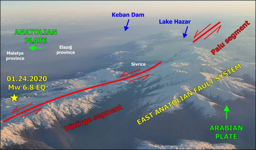
ISSN 2653-9454
                                                                                     Issue No. 16, January 2020 | 3

                        THE JANUARY 24, 2020, Mw 6.8 ELAZIĞ EARTHQUAKE

On January 24, 2020, an earthquake struck the            the epicenter and the Malatya city in distance of 65
eastern part of Turkey. Based on various                 km west of the epicenter. Very heavy structural
seismological observatories and institutes including     damage comprised partial or total collapse of
KOERI, USGS, INGV, GCMT, CPPT, ERD, IPGP, GFZ            buildings.
and EMSC , the magnitude has been assessed as
Mw 6.7 or 6.8. Its epicenter was located in the          According to the “Turkey Disaster Response Plan”,
Elazığ province, at a distance of about 20 km            many working groups were working in the region
southwest of the Lake Hazar. Its focal depth ranged      round the clock in an effort to carry out
from 10 to 23 km. Based on the provided focal            uninterrupted search and rescue, health, support
plane solutions, the mainshock was generated by          activities under the coordination of the Disaster and
the activation of a NE-SW striking strike-slip fault.    Emergency Management Authority (AFAD) affiliated
The main shock was felt in the neighboring               to the Ministry of Interior Affairs.
Armenia, Syria, Iran and Iraq.
                                                         Based on the press release of AFAD on January 28,
The aftershock sequence until January 28, 2020           search and rescue activities resulted in the rescue
comprised 640 aftershocks with magnitude ranging         of 45 people. Unfortunately, the earthquake claimed
from 1.3 to 5.1 (KOERI). 17 aftershocks have been        the lives of 41 people, 37 in Elazığ and 4 in Malaya.
equal to or larger than M 4.0. The largest               1539 of 1607, who applied for medical care in the
aftershock was generated on January 25 and its           aftermath of the earthquake, have been released
magnitude has been assessed as Mw 5.1.                   from the hospitals while 68 of them are still under
                                                         treatment and 13 of them are currently in the
The most earthquake-affected areas were the Elazığ       intensive care units.
and Malatya cities in the Elazığ and Malatya
provinces respectively. More specifically, Elazığ city
was located in a distance of about 34 km north of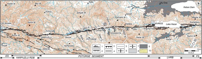
ISSN 2653-9454
                                                                                     Issue No. 16, January 2020 | 4

                THE JANUARY 24, 2020 Mw 6.8 ELAZIĞ EARTHQUAKE-AFFECTED AREA

The earthquake was generated by the rupture of the Pütürge segment of the East Anatolian Fault System, which
comprises a major active left-lateral strike-slip fault zone in eastern Turkey. It forms the tectonic boundary
between the Anatolian Plate and the northward-moving Arabian Plate. The most affected areas are the Elazığ city
and the Malatya city in the respective provinces. Damage was also reported in Sivrice and Pütürge districts.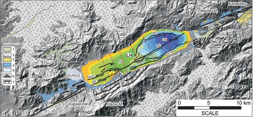
ISSN 2653-9454
                                                   Issue No. 16, January 2020 | 5

THE JANUARY 24, 2020 Mw 6.8 ELAZIĞ EARTHQUAKE-AFFECTED AREA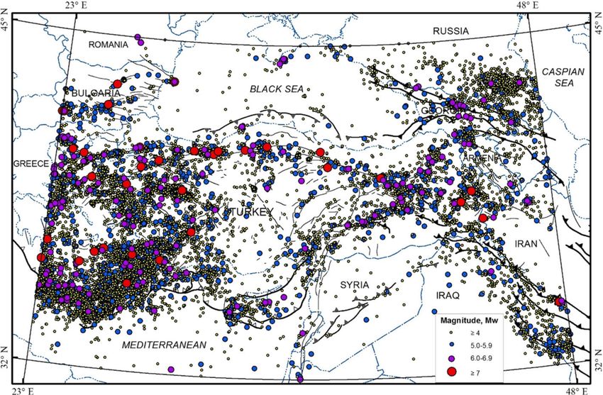
ISSN 2653-9454
                                                                                     Issue No. 16, January 2020 | 6

        THE MAIN FAULT SYSTEMS OF THE ANATOLIAN AND ARABIAN PLATES BOUNDARIES

AN: Anatolian microplate; AF: African plate; AR: Arabian plate; EU: Eurasian plate; NAFZ: North Anatolian Fault
Zone; EAFZ: East Anatolian Fault Zone; DSFZ: Dead Sea Fault Zone; MF: Malatya Fault; TF: Tuzgölü fault; EF:
Ecemiş fault; SATZ: Southeast Anatolian Thrust Zone; SS: southern strand of the EAFZ; NS: northern strand of
the EAFZ (From Duman and Emre, 2013).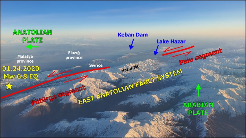
ISSN 2653-9454
                                                                                     Issue No. 16, January 2020 | 7

                   ACTIVE FAULT MAP OF THE EASTERN MEDITERRANEAN REGION

The active fault map of Turkey illustrating the North Anatolian Fault Zone and the Eastern Anatolian Fault Zone
among others (From Duman et al., 2016). The epicenter of the January 24, 2020 Eastern Turkey is located along
the main strand of the Eastern Anatolian Fault Zone.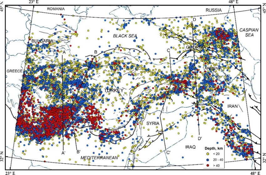
ISSN 2653-9454
                                                                                Issue No. 16, January 2020 | 8

                    HISTORICAL SEISMICITY OF THE ANATOLIA REGION

Historical earthquake distribution across Turkey and the surrounding region from BC 2000 to AD 1900.
                               Symbols represent the epicentral intensity.
                                       (From Duman et al., 2016)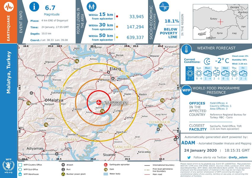
ISSN 2653-9454
                                                          Issue No. 16, January 2020 | 9

     RECENT SEISMICITY OF THE ANATOLIA REGION

       Seismicity of the Anatolia region from 1900 to 2012.
The earthquakes with moment magnitude Mw ≥ 4.0 are presented.
                    (From Duman et al., 2016)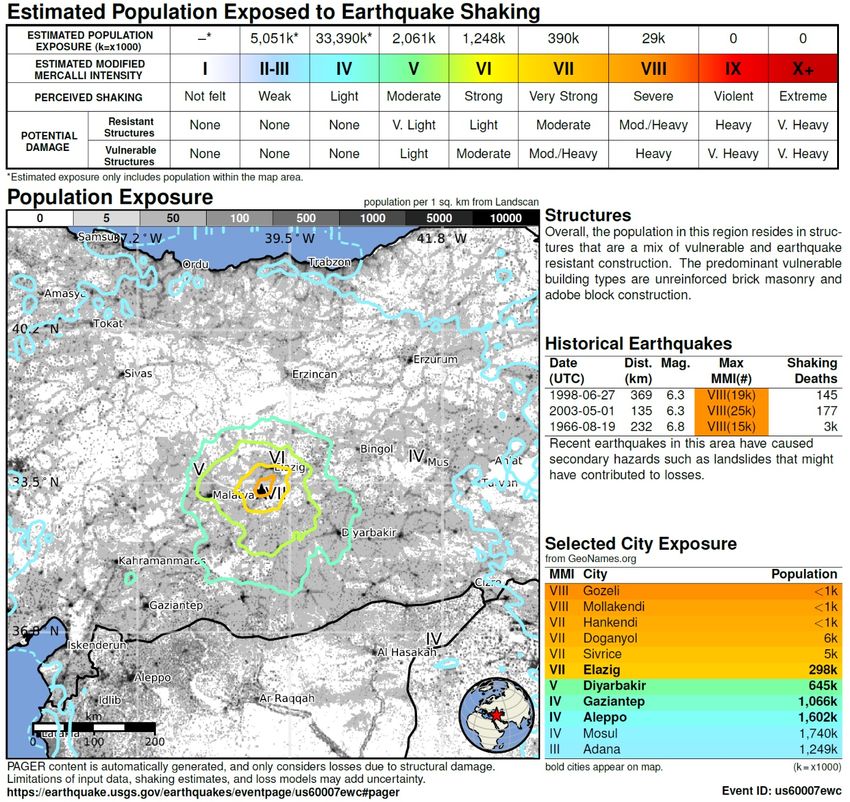
ISSN 2653-9454
                                                                                     Issue No. 16, January 2020 | 10

         FOCAL MECHANISM SOLUTIONS OF EARTHQUAKES AND ACTIVE FAULTS IN TURKEY

Distributions of the lower hemisphere equal area projection plots of the focal mechanism solutions of earthquakes
and active faults in Turkey and the surrounding region. The size of each beachball is related to the earthquake
magnitude. The strike slip earthquakes prevails along the North Anatolian and the East Anatolian Fault Zones.
                                                                                       (From Duman et al., 2016)
ISSN 2653-9454
Issue No. 16, January 2020 | 11
SEISMICITY FROM 1900 TO 2012 ACROSS TURKEY
Distribution of the seismicity from 1900 to 2012 across Turkey
and the surrounding region based on focal depth
(From Duman et al., 2016)ISSN 2653-9454
Issue No. 16, January 2020 | 12
THE 1996 EARTHQUAKE ZONATION MAP OF TURKEY
The 1996 earthquake zonation map of Turkey (http://www.deprem.gov.tr/tr/kategori/deprem-bolgeleriharitasi-
28841). Zone 1 represents the highest seismic hazard whereas pink, yellow and light yellow colors
represent Zones 2, 3 and 4 respectively that display the decreasing trend in seismic hazard. The white color is the
no seismic hazard zone (From Akkar et al., 2018).ISSN 2653-9454
Issue No. 16, January 2020 | 13
THE 2019 EARTHQUAKE HAZARD MAP OF TURKEY
The new Earthquake Hazard Map of Turkey has been prepared with much more detailed data considering the
latest earthquake source parameters, earthquake catalogs and new mathematical models. It came into force on
January 1, 2019. Unlike the previous earthquake zonation map, in the new map, instead of the earthquake zones,
the highest ground acceleration values were shown and the concept of "earthquake zone" was eliminated.
(From https://deprem.afad.gov.tr/deprem-tehlike-haritasi)ISSN 2653-9454
Issue No. 16, January 2020 | 14
THE ACTIVE LEFT-LATERAL STRIKE-SLIP EAST ANATOLIAN FAULT SYSTEM
The East Anatolian Fault (EAF) constitutes a Misis Fault (SMF) system, is about 380 km between
complex left-lateral strike-slip fault zone that Çelikhan and the Gulf of Iskenderun, exhibiting
separates the Anatolian plate from the Arabian characteristic active left-lateral fault features. It
plate. consists of 9 fault segments, which are, from NE to
SW, the Sürgü (227), Göksun (226), Savrun (223),
The eastern part of the EAF exhibits a 295-km long Çokak (222), Misis (216), Toprakkale (219),
narrow deformation zone where it takes the form of Yumurtalık (218), Karatas¸ (217) and Düziçi-
a single fault trace except for jog structures. Τhis Iskenderun (220) fault segments, respectively.
narrow zone implies a zone of higher strength and
of more brittle - non ductile deformation However, Two surface ruptures that developed along the EAF
to the west it is divided into northern and southern in the twentieth century have been mapped. These
fault strands and becomes a 65-km wide are ruptures associated with the 1971 Ms 6.8 Bingöl
deformation zone. The southern strand is the main earthquake and the 2010 Mw 6.1 Karakoçan
fault. The main EAF zone is about 580 km-long earthquake. Additionally it is known that the EAF to
between Karlıova and Antakya including the the east of Lake Hazar was also ruptured by the
southern strand, and is divided into the 7 fault 1874 Ms 7.1, 1875 Ms 6.7, and 1866 Ms 7.2
segments from NE to SW, namely, the Karlıova (2- earthquakes.
1), Ilıca (2-2), Palu (2-3), Pütürge (2-4), Erkenek
(2-5), Pazarcık (2-6), and Amanos (2-7) segments (From Emre et al., 2013, 2016)
(numbers refer to the following map). The lengths
of the segments vary from 31 to 112 km, while their
strikes vary from N35°E to N75°E.
The northern strand of the EAF, called the Sürgü-ISSN 2653-9454
Issue No. 16, January 2020 | 15
THE EAST ANATOLIAN STRIKE-SLIP FAULT SYSTEM
(From Emre et al., 2016)ISSN 2653-9454
Issue No. 16, January 2020 | 16
PROBABILISTIC SEISMIC HAZARD MAP OF EASTERN TURKEY
475 year return period regional peak ground acceleration (PGA) distribution according to the recently updated
(2018) probabilistic earthquake hazard map of Turkey. The vicinity of the Pütürge segment is associated with PGA
values in the order of 0.6-0.7 g. (From https://eqe.boun.edu.tr/sites/che.boun.edu.tr/files/elazig-
sivrice_earthquake_24-01-2020-bu-koeri_earthquake_engineering_v1.pdf)ISSN 2653-9454
Issue No. 16, January 2020 | 17
THE EAST ANATOLIAN STRIKE-SLIP FAULT SYSTEM
Map of the East Anatolian strike-slip fault system showing strands, segments and fault jogs. FS: fault Segment;
RB: releasing bend; RS: releasing stepover; RDB: restraining double bend; RSB: restraining bend; PB: paired
bend; (1) Düziçi–Osmaniye fault segment; (2) Erzin fault segment; (3) Payas fault segment; (4) Yakapınar fault
segment; (5) Çokak fault segment; (6) Islahiye releasing bend; (7) Demrek restraining stepover; (8) Engizek
fault zone; (9) Maraş fault zone (From Duman and Emre, 2013).ISSN 2653-9454
Issue No. 16, January 2020 | 18
DISTRIBUTION OF HISTORICAL EARTHQUAKES
ALONG THE EAST ANATOLIAN FAULT SYSTEM
From Duman and Emre (2013)ISSN 2653-9454
Issue No. 16, January 2020 | 19
DISTRIBUTION OF INSTRUMENTALLY RECORDED EARTHQUAKES
ALONG THE EAST ANATOLIAN FAULT SYSTEM
From Duman and Emre (2013)ISSN 2653-9454
Issue No. 16, January 2020 | 20
THE PÜTÜRGE GAP ALONG THE MAIN FAULT STRAND OF THE EAST ANATOLIAN FAULT SYSTEM
The Pütürge segment extends between the Lake developed in the tributaries of the Şiro River and
Hazar releasing bend and the Yarpuzlu restraining range from several tens of meters to one kilometer
double bend. The fault traverses mountainous long. Cumulative left-lateral offsets of about 550
terrain and tends to follow linear valleys, where it and 450 m were measured in the Delan and Bobik
cuts Palaeozoic-Mesozoic metamorphic rocks, rivers.
Mesozoic ophiolitic mélange and
volcanosedimentary rocks. Measured geological The timing of the previous surface rupture is
offsets of basement rocks and morphological offsets unknown. The 1875 (Ms 6.7) and 1905 (Ms 6.8)
in the Fırat River valley vary from 9 to 22 km. earthquakes might have been generated along this
segment based on Ambraseys (1988).
The segment varies from transtensional to
transpressional modes from east to west. The
segment comprises sections with lengths varying
from 21 to 28 km, separated from each other by
restraining stepovers and a bend about 0.5 km
wide. The segment is characterized by two parallel
faults 9 km long to the west of Lake Hazar.
The segment cuts and offsets various rivers
including Fırat River. Duman and Emre (2013)
measured an 11 km left-lateral offset in the valley
to the SW of Lake Hazar. This measurement
represents the total fault offset from Pliocene to
recent time. Systematic left lateral offsets areISSN 2653-9454
Issue No. 16, January 2020 | 21
SURFACE RUPTURES PRODUCED BY LARGE EARTHQUAKES AND SEISMIC GAPS
THE PÜTÜRGE GAP
Surface ruptures produced by large earthquakes during the 19th and 20th centuries along the Eastern Anatolian
Fault System. Ruptured fault segments are highlighted. Seismic gaps are recognized on some segments of the
Eastern Anatolian Fault System based on historical and instrumental earthquake data (From Duman and Emre,
2013). The January 24, 2020 Eastern Turkey earthquake was generated along the Pütürge gap.ISSN 2653-9454
Issue No. 16, January 2020 | 22
THE PÜTÜRGE GAP ALONG THE MAIN FAULT STRAND
OF THE EAST ANATOLIAN FAULT SYSTEM
Map of the Pütürge segment of the East Anatolian fault system. LHRB: Lake Hazar releasing bend; PS: Palu
segment; ES: Erkenek segment; H: hill; M: mountain; C: creek; 1: left lateral strike-slip fault; 2: normal fault; 3:
reverse or thrust fault; 4: East Anatolian Fault; 5: Southeastern Anatolian Thrust Zone; 6: syncline; 7: anticline;
8: undifferentiated Holocene deposits; 9: undifferentiated Quaternary deposits; 10: landslide, “x” and “y” are
used to indicate the amount of slip (From Duman and Emre, 2013).ISSN 2653-9454
Issue No. 16, January 2020 | 23
THE PÜTÜRGE GAP ALONG THE MAIN FAULT STRAND
OF THE EAST ANATOLIAN FAULT SYSTEM
Map of the Pütürge segment (2-4) of the East Anatolian fault system
(From the Active Fault Map of Turkey in 1:1250000 scale by Emre et al., 2013)ISSN 2653-9454
Issue No. 16, January 2020 | 24
THE PÜTÜRGE GAP AND ITS ACCOMPANIED STRUCTURES
Active fault and Quaternary geological map of the Lake Hazar releasing bend and its vicinity. PS: Palu segment;
PUS: Pütürge segment; LH: Lake Hazar; K: Kilise Island; MF: Master Fault; NF: Northern Fault; SF: Southern
Fault; NwS: Northwestern Splay; DB: deep basin; FB: flat basin; SeB: small-elongated basin; M: mountain; 1:
Holocene river bed deposits; 2: Holocene floodplain deposits; 3: colluvium; 4: Holocene fan deposits; 5:
Holocene marsh deposits; 6: left-lateral strike-slip fault; 7: normal fault (From Duman and Emre, 2013).ISSN 2653-9454
Issue No. 16, January 2020 | 25
THE EAST ANATOLIAN STRIKE-SLIP FAULT SYSTEM
LARGE EARTHQUAKES AND SEISMIC GAPS
https://twitter.com/Paleosismolog/status/1221394032661880833/photo/1ISSN 2653-9454
Issue No. 16, January 2020 | 26
HISTORICAL EARTHQUAKES IN THE EAST ANATOLIAN FAULT SYSTEM
Distribution of earthquakes in the East Anatolian Fault Zone from 1500 to 1988, marked with year of occurrence.
Size of dots corresponds to magnitudes 6.0 and 7.0 respectively (From Ambraseys, 1989).ISSN 2653-9454
Issue No. 16, January 2020 | 27
HISTORICAL EARTHQUAKES AND DAMAGED LOCALITIES
IN THE EAST ANATOLIAN FAULT SYSTEM
995 earthquake
Localities damaged from the 995 earthquake based on Guidoboni et al. (1994) and Ambraseys (2009)
(From https://eqe.boun.edu.tr/sites/che.boun.edu.tr/files/elazig-sivrice_earthquake_24-01-2020-bu-
koeri_earthquake_engineering_v1.pdf)ISSN 2653-9454
Issue No. 16, January 2020 | 28
HISTORICAL EARTHQUAKES AND DAMAGED LOCALITIES
IN THE EAST ANATOLIAN FAULT SYSTEM
1789 earthquake
Localities damaged from the May 28, 1789 Elazığ earthquake based on Ambraseys (2009)
(From https://eqe.boun.edu.tr/sites/che.boun.edu.tr/files/elazig-sivrice_earthquake_24-01-2020-bu-
koeri_earthquake_engineering_v1.pdf)ISSN 2653-9454
Issue No. 16, January 2020 | 29
HISTORICAL EARTHQUAKES AND DAMAGED LOCALITIES
IN THE EAST ANATOLIAN FAULT SYSTEM
1866 earthquake
Localities damaged from the May 12, 1866 Göynük earthquake based on Ambraseys (1997)
(From https://eqe.boun.edu.tr/sites/che.boun.edu.tr/files/elazig-sivrice_earthquake_24-01-2020-bu-
koeri_earthquake_engineering_v1.pdf)ISSN 2653-9454
Issue No. 16, January 2020 | 30
HISTORICAL EARTHQUAKES AND DAMAGED LOCALITIES
IN THE EAST ANATOLIAN FAULT SYSTEM
1874 earthquake
Localities damaged from the May 3, 1874 Gölcük earthquake based on Ambraseys (2009)
(From https://eqe.boun.edu.tr/sites/che.boun.edu.tr/files/elazig-sivrice_earthquake_24-01-2020-bu-
koeri_earthquake_engineering_v1.pdf)ISSN 2653-9454
Issue No. 16, January 2020 | 31
HISTORICAL EARTHQUAKES AND DAMAGED LOCALITIES
IN THE EAST ANATOLIAN FAULT SYSTEM
1874
earthquake
Epicentral region of the Gölcük Gölü earthquake of 1874. Dashed lines show the approximate location of East
Anatolian Fault in the epicentral region. Large star indicates adopted location of epicentre and small star shows
epicentre of foreshock of January 14, 1874 (From Ambraseys, 1989).ISSN 2653-9454
Issue No. 16, January 2020 | 32
HISTORICAL EARTHQUAKES AND DAMAGED LOCALITIES
IN THE EAST ANATOLIAN FAULT SYSTEM
1893
earthquake
Macroseismic intensities and epicentral area of South Malatya earthquake of 1893. Dashed lines show the East
Anatolian Fault system and star shows adopted location of the epicenter. Crosses indicate abandoned sites
(From Ambraseys, 1989).ISSN 2653-9454
Issue No. 16, January 2020 | 33
HISTORICAL EARTHQUAKES AND DAMAGED LOCALITIES
IN THE EAST ANATOLIAN FAULT SYSTEM
1905
earthquake
Macroseismic intensities and epicentral area of the Malatya earthquake of 1905. Dashed lines show location of
East Anatolian Fault system and star shows adopted macroseismic epicentre (From Ambraseys, 1989).ISSN 2653-9454
Issue No. 16, January 2020 | 34
EPICENTER FOR THE JANUARY 24, 2020 ELAZIĞ EARTHQUAKEISSN 2653-9454
Issue No. 16, January 2020 | 35
QUICK SOLUTIONS AND REGIONAL MOMENT TENSORS
FOR THE JANUARY 24, 2020 ELAZIĞ EARTHQUAKEISSN 2653-9454
Issue No. 16, January 2020 | 36
DISTRIBUTION OF POPULATION IN THE EPICENTRAL AREA
OF THE JANUARY 24, 2020 ELAZIĞ EARTHQUAKEISSN 2653-9454
Issue No. 16, January 2020 | 37
INTENSITY MAP
FOR THE JANUARY 24, 2020 ELAZIĞ EARTHQUAKEISSN 2653-9454
Issue No. 16, January 2020 | 38
PEAK GROUND ACCELERATION AND PEAK GROUND VELOCITY MAPS
FOR THE JANUARY 24, 2020 ELAZIĞ EARTHQUAKEISSN 2653-9454
Issue No. 16, January 2020 | 39
SPECTRAL RESPONSE
FOR THE JANUARY 24, 2020 ELAZIĞ EARTHQUAKEISSN 2653-9454
Issue No. 16, January 2020 | 40
ESTIMATED LOSSES
FOR THE JANUARY 24, 2020 ELAZIĞ EARTHQUAKE
Estimated fatalities
Yellow alert for shaking-related
fatalities. Some casualties are possible.
https://earthquake.usgs.gov/archive/pro
duct/losspager/us60007ewc/us/1579975
Estimated Economic Losses 220832/onepager.pdf
Orange alert for economic losses.
Significant damage is likely and the
disaster is potentially widespread.
Estimated economic losses are less than
1% of GDP of Turkey. Past events with
this alert level have required a regional
or national level response.ISSN 2653-9454
Issue No. 16, January 2020 | 41
POPULATION EXPOSURE
TO THE JANUARY 24, 2020 ELAZIĞ EARTHQUAKE SHAKING
https://earthquake.usgs.gov/archiv
e/product/losspager/us60007ewc/u
s/1579975220832/onepager.pdfISSN 2653-9454
Issue No. 16, January 2020 | 42
POTENTIAL DISASTER IMPACT AND POTENTIAL AFTERSHOCK IMPACT MAPS
FOR THE JANUARY 24, 2020 ELAZIĞ EARTHQUAKE
https://www.facebook.com/catnewsde/phot https://www.facebook.com/catnewsde/phot
os/a.335140110019648/1279674702232846 os/a.335140110019648/1279763705557279
/?type=3&theater /?type=3&theaterISSN 2653-9454
Issue No. 16, January 2020 | 43
AUTOMATICALLY GENERATED DISASTER ALERT
FOR THE JANUARY 24, 2020 ELAZIĞ EARTHQUAKE
Automatic Disaster Analysis and Mapping (ADAM) Disaster Alerts
https://twitter.com/WFP_ADAM/status/1220772150568804356/photo/1ISSN 2653-9454
Issue No. 16, January 2020 | 44
AUTOMATICALLY GENERATED SHAKE MAP
FOR THE JANUARY 24, 2020 ELAZIĞ EARTHQUAKE
Automatic Disaster Analysis and Mapping (ADAM) Disaster Alerts
https://twitter.com/WFP_ADAM/status/1220804828819009537/photo/1ISSN 2653-9454
Issue No. 16, January 2020 | 45
EMERGENCY RESPONSE COORDINATION CENTER - DG ECHO DAILY MAP
ON JANUARY 27, 2020
https://erccportal.jrc.ec.europa.eu/getdailymap/docId/3207ISSN 2653-9454
Issue No. 16, January 2020 | 46
AFTERSHOCK SEQUENCE
OF THE JANUARY 24, 2020 ELAZIĞ EARTHQUAKE
Number of aftershocks generated after the mainshock on January
24 to January 28, 2020. The number of aftershocks is decreasing
over time.
From http://www.koeri.boun.edu.tr/sismo/2/wp-
content/uploads/2020/01/24_Ocak_2020_Sivrice_Elazig_Depremi_V8.pdfISSN 2653-9454
Issue No. 16, January 2020 | 47
AFTERSHOCK SEQUENCE
OF THE JANUARY 24, 2020 ELAZIĞ EARTHQUAKE
The aftershock sequence from January 24-28, 2020 comprised 640 seismic events. 22 events have been assessed
between 4.0 and 4.9. The largest aftershock has been assessed as 5.1 on January 25.
(From http://www.koeri.boun.edu.tr/sismo/2/wp-
content/uploads/2020/01/24_Ocak_2020_Sivrice_Elazig_Depremi_V8.pdf).ISSN 2653-9454
Issue No. 16, January 2020 | 48
SURFACE DISPLACEMENT INDUCED BY THE JANUARY 24, 2020 ELAZIĞ EARTHQUAKE
The research team of the National Observatory of seismological data including fault plane solutions
Athens (NOA) comprising Dr. Athanassios Ganas, and aftershock distribution of the main shock.
Research Director of the Geodynamic Institute of Based on the data presented it is concluded that (i)
NOA, Varvara Tsironi, PhD Candidate in the Patras the total length of the rupture is 40 km, (ii) the fault
University and NOA researcher and Dr. Sotirios plane dips northwards and (iii) the deformation area
Valkaniotis, scientific collaborator of NOA) is 3500 km2 (50 km on the N-S axis and 70 km on
presented the first results of the processing of the the E-W axis).
satellite synthetic aperture radar (SAR) images for
the M=6.8 earthquake in Elaziğ (Eastern Turkey) In total, relative displacement of about 55 cm was
(pages 49-50). The image is very clear except for measured along the line of sight (LOS) on either
areas covered with snow (mountain peaks) and side of the ruptured fault (Puterge segment) and
deep valleys that the satellite cannot observe. the length of the rupture was assessed as 40 km.
Based on the data presented by the research team
of the National Observatory of Athens (NOA), the
following can be drawn:
The wrapped interferogram shows that the northern
fault block presented displacement of 19.6 cm and From Tsironi and Ganas (2020) and
the southern fault block displacement of 14 cm. Valkaniotis, Tsironi and Ganas (2020)
Close to the ruptured fault the displacement has
been measured as 28 cm. These measurements
coincides with the left lateral strike-slip offset of the
Eastern Anatolian Fault Zone as well as with theISSN 2653-9454
Issue No. 16, January 2020 | 49
SURFACE DISPLACEMENT
INDUCED BY THE JANUARY 24, 2020 ELAZIĞ EARTHQUAKE
Wrapped interferogram (descending orbit) for the January 24, 2020 Mw 6.8 Elazığ earthquake.
From Tsironi and Ganas (2020)ISSN 2653-9454
Issue No. 16, January 2020 | 50
SURFACE DISPLACEMENT
INDUCED BY THE JANUARY 24, 2020 ELAZIĞ EARTHQUAKE
Sentinel-1 SAR unwrapped interferogram (ascending orbit) for the January 24, 2020 Mw 6.8 Elazığ earthquake.
Color shows displacement relative to satellite (line-of-sight).
From Valkaniotis et al. (2020)ISSN 2653-9454
Issue No. 16, January 2020 | 51
SURFACE DISPLACEMENT
INDUCED BY THE JANUARY 24, 2020 ELAZIĞ EARTHQUAKE
Differential interferogram of the
January 24, 2020, Mw 6.8 Elazığ,
Turkey earthquake.Two acquisitions
of ascending track 116 of the
SENTINEL-1 (developed by ESA for
Copernicus initiate) satellite, i.e. one
before (21/1/2020) and one after
(27/1/2020) earthquake has been
exploited 1/3.
https://twitter.com/LastQuake/status/
1222076833711169541ISSN 2653-9454
Issue No. 16, January 2020 | 52
SURFACE DISPLACEMENT
INDUCED BY THE JANUARY 24, 2020 ELAZIĞ EARTHQUAKE
Ground surface displacement data from Elazig Turkey earthquake
from the NERC Centre for the Observation and Modelling of Earthquakes, Volcanoes and Tectonics
(From https://twitter.com/jrelliott82/status/1222074014723649536)ISSN 2653-9454
Issue No. 16, January 2020 | 53
EARTHQUAKE ENVIRONMENTAL EFFECTS
INDUCED BY THE JANUARY 24, 2020 ELAZIĞ EARTHQUAKE
Ground cracks were induced in sites with existing instability. No surface faulting has been observed.
(From https://twitter.com/tsancar/status/1221480276846616578,
https://twitter.com/tsancar/status/1222200667298770945)ISSN 2653-9454
Issue No. 16, January 2020 | 54
EARTHQUAKE ENVIRONMENTAL EFFECTS
INDUCED BY THE JANUARY 24, 2020 ELAZIĞ EARTHQUAKE
Ground cracks are attributed to the ground shaking close to gravitational movements observed in the affected
area. Rockfalls and landslides were also observed in the same sites.
(From https://twitter.com/tsancar/status/1221480276846616578)ISSN 2653-9454
Issue No. 16, January 2020 | 55
EARTHQUAKE ENVIRONMENTAL EFFECTS
INDUCED BY THE JANUARY 24, 2020 ELAZIĞ EARTHQUAKE
Liquefaction phenomena were generated along ground cracks. Hydrological anomalies
comprised the formation of new hot sping within the Şiro River bed in Pütürge-Malatya area.
(From https://twitter.com/tsancar/status/1221480276846616578,
https://twitter.com/tsancar/status/1222081414109237248)ISSN 2653-9454
Issue No. 16, January 2020 | 56
COPERNICUS
EMERGENCY MANAGEMENT SERVICE - MAPPING
Data and maps of the Copernicus
Emergency Management
Service/Mapping are freely available
08 to all agencies and everyone
competent to search and rescue
10
operations and to the disaster
09 management during the first crucial
11 hours of the disaster response
01 06 07 phase. Maps were produced for the
following affected areas in Eastern
04
Turkey:
03 01 Malatya
05 12 02 Cermik
13 02 03 Cungus
14 04 Doganyol
05 Puturge
06 Sivrice
07 Maden
08 Elazig
09 Sintil
10 Hankendi
11 Akcakale
From 12 Gokce
https://emergency.copernicus.eu/mapping/sites/default/files/thumbnails 13 Karakaya
/EMSR423-AEM-1580198124-r05-v1.jpg 14 CevizpinarISSN 2653-9454
Issue No. 16, January 2020 | 57
COPERNICUS MAP FOR GÖKÇE
https://emergency.copernicus.eu/mapping/system/files/components/EMSR423_AOI12_GRA_PRODUCT_r1_RTP01_v1.jpgISSN 2653-9454
Issue No. 16, January 2020 | 58
COPERNICUS MAP FOR CEVIZPINAR
https://emergency.copernicus.eu/mapping/system/files/components/EMSR423_AOI14_GRA_PRODUCT_r1_RTP01_v1.jpgISSN 2653-9454
Issue No. 16, January 2020 | 59
COPERNICUS MAPS FOR KARAKAYA
https://emergency.copernicus.eu/mapping/system/files/components/EMSR423_AOI13_GRA_PRODUCT_r1_RTP01_v1.jpg
https://emergency.copernicus.eu/mapping/system/files/components/EMSR423_AOI13_GRA_PRODUCT_r1_RTP02_v1.jpg
https://emergency.copernicus.eu/mapping/system/files/components/EMSR423_AOI13_GRA_PRODUCT_r1_RTP03_v1.jpgISSN 2653-9454
Issue No. 16, January 2020 | 60
COPERNICUS MAP FOR HANKENDI
https://emergency.copernicus.eu/mapping/system/files/components/EMSR423_AOI10_GRA_PRODUCT_r1_RTP01_v1.jpgISSN 2653-9454
Issue No. 16, January 2020 | 61
COPERNICUS MAP FOR ELAZIĞ CITY
https://emergency.copernicus.eu/mapping/system/files/components/EMSR423_AOI08_GRA_PRODUCT_r1_RTP01_v1.jpgISSN 2653-9454
Issue No. 16, January 2020 | 62
COPERNICUS MAP FOR ELAZIĞ CITY
https://emergency.copernicus.eu/mapping/system/files/components/EMSR423_AOI08_GRA_PRODUCT_r1_RTP02_v1.jpgISSN 2653-9454
Issue No. 16, January 2020 | 63
COPERNICUS MAP FOR ELAZIĞ CITY
https://emergency.copernicus.eu/mapping/system/files/components/EMSR423_AOI08_GRA_PRODUCT_r1_RTP03_v1.jpgISSN 2653-9454
Issue No. 16, January 2020 | 64
COPERNICUS MAP FOR DOGANYOL
https://emergency.copernicus.eu/mapping/system/files/components/EMSR423_AOI04_GRA_PRODUCT_r1_RTP01_v1.jpgISSN 2653-9454
Issue No. 16, January 2020 | 65
COPERNICUS MAP FOR PÜTÜRGE
https://emergency.copernicus.eu/mapping/system/files/components/EMSR423_AOI05_GRA_PRODUCT_r1_RTP01_v1.jpgISSN 2653-9454
Issue No. 16, January 2020 | 66
RESIDENTIAL BUILDINGS IN TURKEY
A B
C (A) Total number of buildings and occupancy units in
Turkey
(B) Proportions of occupancy units by the
construction year of buildings in Istanbul and Turkey
(C) Distribution of occupancy units by the number of
floors in the building in Istanbul and Turkey
From Gunes (2015) and
the Turkish Statistical Institute (TUIK)ISSN 2653-9454
Issue No. 16, January 2020 | 67
DOMINANT TYPES OF RESIDENTIAL BUILDINGS IN TURKEY
A
(A) Distribution of buildings in Istanbul and Turkey by
their structural system: frame, masonry, other type.
(B) Representative examples of buildings based on
their construction period. Four generations are
presented: 1960s, 1970s, 1980s, 1990s and later.
From Gunes (2015) and
the Turkish Statistical Institute (TUIK)
BISSN 2653-9454
Issue No. 16, January 2020 | 68
DOMINANT BUILDING TYPES IN THE AFFECTED AREA
REINFORCED CONCRETE (RC) BUILDINGS WITH RC FRAME AND INFILL WALLS OF DIFFERENT PERIODS
In general, Turkish residential buildings in urban The previously enforced 2007 version was the first to
regions have reinforced concrete structural systems include state of the art performance based
(Cogurcu et al., 2015). However, some of them have evaluation concepts. It has been revised in 2018 and
several deficiencies, such as low concrete quality, became legally effective on January 1, 2019.The new
non-seismic reinforcement detailing and code consists of 17 chapters, most of them revised,
inappropriate structural systems including several where there are new chapters on high-rise,
architectural irregularities among others (Cogurcu et seismically isolated, cold-formed steel and timber
al., 2015). Because most of the current buildings in buildings within the code.
Turkey were constructed before Turkish Earthquake The dominant building type in the affected cities of
Code 2007 (TEC 2007), their earthquake-resistance the 2020 Elaziğ earthquake is the reinforced concrete
features are insufficient and their structural (RC) structures with RC frame and infill walls. These
irregularities pose a danger. Another important point structures are built in different periods with the more
is that many of the buildings that have structural recent ones designed and constructed according to
irregularities are high-rise buildings. stringent antiseismic building codes.ISSN 2653-9454
Issue No. 16, January 2020 | 69
BUILDING INSURANCE AGAINST EARTHQUAKE RISK IN TURKEY
Seismic hazard zones map of Eastern Turkey
Percentage of building insurance against
earthquakes in the provinces of Eastern Turkey
(data from AKSAN newspaper published on January 25, 2020)
Building insurance against earthquakes in Turkey is widespread. The total number of buildings in Turkey is 17.682.050
buildings, of which 9.500.000 buildings (53.8%) are insured. In the January 2020 earthquake-affected area, it is clear that
the heavier damage was reported in Elaziğ and Malatya provinces, which are characterized by low percentage of insured
housing (35% and 38% respectively). In contrast, provinces with higher percentage of insured housing have suffered
slight damage. It is significant to note that in Bingöl province, which was severely affected in 2003 by an earthquake with
Mw 6.4 and maximum IXMM, the percentage of insured buildings is one of the highest in Eastern Turkey.ISSN 2653-9454
Issue No. 16, January 2020 | 70
BUILDING DAMAGE
IN THE MOST AFFECTED CITIES OF EASTERN TURKEY
As a part of damage detection activities, 1.521 buildings were surveyed.
Results of damage detection activities are written above.
https://en.afad.gov.tr/press-release-17--response-and-rehabilitation-continues-in-the-aftermath-of-
earthquake-in-elazig-and-malatyaISSN 2653-9454
Issue No. 16, January 2020 | 71
DAMAGE IN RC BUILDINGS (1/3)
Close to Elaziğ city, there is a residential complex consisting
of about 10 5-storey residential buildings which are identical,
based on a uniform horizontal ground. The damage observed
was almost identical comprising column damage at a height
of about 70 - 80 cm from the ground. This damage is
attributed to poor construction quality in combination with
the prevailing strong vertical component of the earthquake
ground motion.ISSN 2653-9454
Issue No. 16, January 2020 | 72
DAMAGE IN RC BUILDINGS (2/3)
Light damage comprise detachment of plaster pieces
from the brick infill walls and detachment of pieces of
concrete from the columns in the corners where the
walls meet. The first damage is non-structural, while
the second can adversely affect the antiseismic
performance of the building by reducing the strength of
the columns. The presented damage was generated in
the lower parts of the building and more specifically in
the ground floor.ISSN 2653-9454
Issue No. 16, January 2020 | 73
DAMAGE IN RC BUILDINGS (3/3)
Similar non-structural damage in the infill
walls and structural damage in the columns
in the corners of the ground floor of a
reinforced concrete building in Elaziğ city.ISSN 2653-9454
Issue No. 16, January 2020 | 74
DAMAGE IN MOSQUES
The majority of mosques in the affected area were built with masonry techniques. The mosques generally feature
one or more domes, the surrounding masonry walls and the adjacent minarets. In the affected areas of eastern
Turkey, mosques suffered damage to the surrounding walls comprising detachment of plasters from the masonry
walls, cracking and partial collapse of the masonry walls.ISSN 2653-9454
Issue No. 16, January 2020 | 75
DAMAGE IN MINARETS
Based on Oliveira et al. (2012), the basic elements of the minaret are:
footing, boot, transition segment, cylindrical or polygonal body, stairs,
balcony, upper part of the minaret body, spire/cap and end ornament.
They may be built with cut-stone, brick, or a mixture of both. The top
is usually a 3-D timber structure covered by 5-mm-thick lead sheets.
Iron clamps hold wall blocks together.
The masonry minarets were observed to fail in their upper part of their
body, in their spire and in their end ornament. Most minarets in Elaziğ
city present failure of the end ornament and collapse of the spire
attributed to the action of the vertical component of the earthquake
ground motion and the excitation of construction with small amplitude
high seismic vibration of several cycles.
From Oliveira et al. (2012)
Minarets in Elaziğ cityISSN 2653-9454
Issue No. 16, January 2020 | 76
VERY HEAVY STRUCTURAL DAMAGE IN RC BUILDINGS
PARTIALLY OR TOTALLY COLLAPSED BUILDINGS IN ELAZIĞ CITY
A partially collapsed building in Elaziğ city. It
appears to be identical in construction to
adjacent buildings. The adjacent buildings
remained almost intact by the earthquake.ISSN 2653-9454
Issue No. 16, January 2020 | 77
VERY HEAVY STRUCTURAL DAMAGE IN RC BUILDINGS
PARTIALLY OR TOTALLY COLLAPSED BUILDINGS IN ELAZIĞ CITY
This building in Elaziğ city collapsed
almost within its foundation plan in
the well known form of pancake. This
indicates the prevalence of the
vertical component of the earthquake
ground motion, even in this strike-slip
seismic event.
A macroseismic epicenter has been
created close to the affected areas
due to the adverse local soil
conditions.ISSN 2653-9454
Issue No. 16, January 2020 | 78
VERY HEAVY STRUCTURAL DAMAGE IN RC BUILDINGS
PARTIALLY OR TOTALLY COLLAPSED BUILDINGS IN ELAZIĞ CITYISSN 2653-9454
Issue No. 16, January 2020 | 79
VERY HEAVY STRUCTURAL DAMAGE IN RC BUILDINGS
PARTIALLY OR TOTALLY COLLAPSED BUILDINGS IN ELAZIĞ CITY
The presented residential building was among the totally collapsed buildings in Elaziğ city. The destruction was
almost complete with debris leaving no gaps and empty spaces between them. The tangled mass of earthquake
building debris reflects not only the strong seismic motion, but also the poor construction of buildings and the
inadequate quality of construction materials.ISSN 2653-9454
Issue No. 16, January 2020 | 80
VERY HEAVY STRUCTURAL DAMAGE IN RC BUILDINGS
PARTIALLY OR TOTALLY COLLAPSED BUILDINGS IN ELAZIĞ CITY
This multistorey reinforced concrete building in Elaziğ city suffered partial collapse after the January 24, 2020
earthquake. Its remaining still-standing parts are practically undamaged. Spatial homothetic motions indicated
the dominance of the vertical component of the earthquake ground motion.ISSN 2653-9454
Issue No. 16, January 2020 | 81
VERY HEAVY STRUCTURAL DAMAGE IN RC BUILDINGS
PARTIALLY OR TOTALLY COLLAPSED BUILDINGS IN ELAZIĞ CITY
Details of the damage induced by the
January 24, 2020 earthquake on the
previously presented buildingISSN 2653-9454
Issue No. 16, January 2020 | 82
VERY HEAVY STRUCTURAL DAMAGE IN RC BUILDINGS
PARTIALLY COLLAPSED BUILDINGS IN ELAZIĞ CITY
Two buildings in the same neighborhood in Elazig city has suffered collapse of their southwestern parts. The
direction of the collapse indicates not only the direction of maximum ground velocity and acceleration but also
information about the microseismic and macroseismic epicenter.ISSN 2653-9454
Issue No. 16, January 2020 | 83
CONCLUSIONS
The January 24, 2020 Mw 6.98 earthquake in The most affected Elaziğ and Malatya provinces are
Eastern Turkey has been generated by the rupture of characterized by low percentage of insured housing
the Pütürge segment of the Eastern Anatolian Fault, (35% and 38% respectively). In contrast, provinces
which was considered as a seismic gap. with higher percentage of insured housing have
suffered slight damage. It is significant to note that
The affected area of the Eastern Turkey experienced in Bingöl province, which was severely affected in
similar destructive earthquakes in the historical past. 2003 by an earthquake with Mw 6.4 and maximum
The 1875 (Ms 6.7) and 1905 (Ms 6.8) earthquakes IXMM, the percentage of insured buildings is one of
might have been generated along this segment the highest in Eastern Turkey.
based on Ambraseys (1988).
Damage is attributed to the synergy of several
The dominant building type in the affected area of factors comprising poor construction quality,
the 2020 Elaziğ earthquake is the reinforced concrete construction defects, inadequate quality of
(RC) structures with RC frame and infill walls. These construction materials in combination with the
structures are built in different periods with the more prevailing strong vertical component of the
recent ones designed and constructed according to earthquake ground motion.
stringent antiseismic building codes.
The damage was observed in Elaziğ and Malatya
provinces in Eastern Turkey, which are located close
to the ruptured fault.
More specifically, very heavy structural damage was
locally observed in three localities of the
aforementioned provinces, while adjacent localities
remained almost untouched by the earthquake.ISSN 2653-9454
Issue No. 16, January 2020 | 84
Professor Efthymis Lekkas
Em. Professor Panayotis Carydis
PhD c. Spyridon Mavroulis
The January 24, 2020
Mw 6.8 Elazığ (Turkey)
Earthquake
Elazığ , 2020You can also read