Archaeological prospections in the Roman vicus Belginum (Rhineland-Palatinate, Germany)
←
→
Page content transcription
If your browser does not render page correctly, please read the page content below
Express report
E&G Quaternary Sci. J., 68, 5–11, 2019
https://doi.org/10.5194/egqsj-68-5-2019
© Author(s) 2019. This work is distributed under
the Creative Commons Attribution 4.0 License.

Archaeological prospections in the Roman vicus Belginum
(Rhineland-Palatinate, Germany)
Wolf-Rüdiger Teegen1,2 , Rosemarie Cordie3,4 , Philomena Over1 , Simon Mägdefessel1 , Rebecca Retzlaff5 , and
Johannes Stoffels5
1 Institut
         für Vor- und Frühgeschichtliche Archäologie und Provinzialrömische Archäologie,
Ludwig-Maximilians-Universität, Munich, 80539, Germany
2 ArchaeoBioCenter, Ludwig-Maximilians-Universität, Munich, 80539, Germany
3 Klassische Archäologie, Universität Trier, Trier, 54286, Germany
4 Archäologiepark Belginum, Morbach-Wederath, 54497, Germany
5 Umweltfernerkundung und Geoinformatik, Universität Trier, Trier, 54286, Germany

Correspondence:        Wolf-Rüdiger Teegen (w.teegen@lmu.de)

Relevant dates:        Received: 31 January 2019 – Accepted: 21 March 2019 – Published: 11 April 2019

How to cite:           Teegen, W.-R., Cordie, R., Over, P., Mägdefessel, S., Retzlaff, R., and Stoffels, J.: Archaeological
                       prospections in the Roman vicus Belginum (Rhineland-Palatinate, Germany), E&G Quaternary Sci.
                       J., 68, 5–11, https://doi.org/10.5194/egqsj-68-5-2019, 2019.

Abstract:              The Roman vicus Belginum and the associated Celtic–Roman cemetery have been the subject of
                       systematic archaeological research since 1954. Since 2004, archaeological prospections have been
                       carried out in and around Belginum. Participants included students from the universities of Leipzig,
                       Trier, and Munich as part of study-accompanying field work.
                          This paper deals with the prospections of 2004 and 2016, when nearly 2 ha of land south of the
                       federal road B327 (Hunsrückhöhenstraße) were surveyed. The study area is located on a NW-to-SE-
                       running hillside. All non-local objects present on the surface were collected and three-dimensionally
                       recorded. Previously in 2013, the area was geomagnetically prospected by Posselt & Zickgraf (Mar-
                       burg). Both surveys revealed a hitherto unknown extent of the vicus about 200 m to the southwest.
                       The findings date back to the late first to third centuries common era.
                          All finds (ceramic, bricks, roof slate, glass, and metal) were recorded and analysed in a QGIS
                       and ArcGIS environment together with lidar scans, the geomagnetic data, and other geographical
                       information. The overall distributions of bricks and pottery were studied in detail. The distribution of
                       bricks is in particular connected to the individual plots, while the pottery is mainly concentrated in the
                       backyards. Regarding surveys in other Roman vici, the brick distribution could be a helpful indicator
                       to identify plots, when no geophysical information is available.

Kurzfassung:           Der römische vicus Belginum und das zugehörige keltisch-römische Gräberfeld sind seit 1954 Gegen-
                       stand systematischer archäologischer Forschungen. Seit 2004 werden archäologische Prospektionen
                       in und um Belginum durchgeführt. Beteiligt waren Studierende der Universitäten Leipzig, Trier und
                       München im Rahmen von Lehrveranstaltungen.
                          Diese Veröffentlichung stellt die Ergebnisse der Prospektionen von 2004 und 2016 vor. Prospek-
                       tiert wurden etwa 2 ha Fläche südlich der Hunsrückhöhenstraße B327. Das begangene Areal liegt auf

Published by Copernicus Publications on behalf of the Deutsche Quartärvereinigung (DEUQUA) e.V.
6                                            W.-R. Teegen et al.: Archaeological prospections in the Roman vicus Belginum

                          einem von NW zu SO verlaufenden Hang. Sämtliche auf der Geländeoberfläche beobachteten nicht-
                          lokalen Gegenstände wurden dreidimensional eingemessen und eingesammelt. Bereits 2013 war das
                          Gebiet von der Firma Posselt & Zickgraf (Marburg) geomagnetisch prospektiert worden. Beide Sur-
                          veys ergaben eine bis dahin unbekannte Ausdehnung des Vicus um 200 m nach Westen. Die datier-
                          baren Funde, überwiegend Keramik, gehören in den Zeitraum zwischen dem späten 1. Jh. und dem
                          3. Jh. n. Chr.
                             Sämtliche Funde (Keramik, Ziegel, Dachschiefer, Glas und Metall) wurden in einer Lehrver-
                          anstaltung aufgenommen. Die Daten wurden in einer QGIS- und ArcGIS-Umgebung zusammen mit
                          Lidar-Scans, den geomagnetischen Daten und anderen geographischen Informationen analysiert. Die
                          Gesamtverteilungen der Ziegel und Keramik wurden detailliert untersucht. Vor allem die Verteilung
                          der Ziegelfunde folgt den einzelnen, auf dem Magnetometerplot erkennbaren Parzellen. Die Keramik
                          ist dagegen überwiegend im Hinterhofbereich konzentriert. Bei zukünftigen Prospektionen in anderen
                          römischen vici kann die Verteilung der Ziegelfunde ein wichtiges Hilfsmittel zur Identifizierung von
                          Grundstücksparzellen darstellen, wenn keine geophysikalischen Daten vorliegen.

1   Introduction                                                   2     Material and methods

Wederath-Belginum (Gde. Morbach, Kr. Bernkastel-                   2.1     Prospection and data
Wittlich; localization: Fig. 1, insert) is one of the remarkable
                                                                   Since 2004, prospections of various types have been carried
rural archaeological sites in Rhineland-Palatinate, Germany.
                                                                   out at the Belginum site in the framework of course-related
The archaeological ensemble consists of a Celtic and Roman
                                                                   university training with the aim to gain knowledge of the Iron
cemetery, the Roman vicus Belginum with at least three
                                                                   Age settlement (Lukas et al., 2012), the Roman land use, and
sanctuaries and an early Roman military camp (Fig. 1). The
                                                                   the extent of the vicus. Students participating came from the
ancient name of the vicus is known from a Roman inscription
                                                                   universities of Leipzig (UL), Trier (UT), and Munich (LMU).
(. . . vicani belginates. . . ) and from the well-known Tabula
                                                                   Within Belginum’s surroundings (Fig. 1), several villae rusti-
Peutingeriana (Haffner, 1989, inside back cover).
                                                                   cae and at least one settlement of pre-Roman Iron Age could
    Belginum was located at the intersection of the an-
                                                                   be identified as reported by Teegen et al. (2014, with further
cient west–east road, linking the capitals of the Roman
                                                                   references).
provinces Gallia Belgica and Germania Superior, Trier-
Augusta Treverorum and Mainz-Mogontiacum, and the
north–south route connecting the rivers Moselle and Nahe
(Haffner, 1989).                                                   2.1.1    Prospection 2004
    The site Wederath-Belginum has been the subject of sys-
tematic archaeological research since 1954 (overview in            Already in late autumn of 2004, an approximately 50 m
Haffner, 1989, and Cordie, 2007). The burial ground has been       wide and 200 m long strip of ground had been prospected
comprehensively published in six volumes so far (details and       by UL students and staff, along the road to Hintzerath
references in Cordie, 2007).                                       (EV2004,167) (Fig. 1 No. 1). A large number of finds were
    Excavations in the settlement area itself were carried out     discovered in 1670 spots. The Roman pottery and the glass
in 1969–1973 and 2000–2014. The excavations showed that            finds generally date back to the first to third centuries com-
strip houses were present at the Belginum. They are typical        mon era. The find distributions were analysed in a LMU
for the Roman northwest provinces. The plots are about 10 m        bachelor thesis by Mägdefessel (2018) using the geographic
wide and up to 80 m long. A (stone) cellar is located near to      information system QGIS (QGIS Development Team, 2018).
the street and the building begins above the cellar. A porti-
cus is set in front of the house. The house with half-timbered
construction extends about 20–25 m into the rear part of the
                                                                   2.1.2    Geomagnetic prospection 2013
property (Cordie et al., 2013). Such a plot organization can
also be seen on the images of the new geomagnetic prospec-         In advance of the construction work for the federal road
tions (see Figs. 2–3).                                             B50neu, large areas south of the federal road B327 (Hun-
                                                                   srückhöhenstraße) were geomagnetically prospected in 2013
                                                                   by the company Posselt & Zickgraf (Marburg) (see below
                                                                   Figs. 2–3). Surprisingly, it turned out that the vicus extends
                                                                   about 200 m further to the west.

E&G Quaternary Sci. J., 68, 5–11, 2019                                                www.eg-quaternary-sci-j.net/68/5/2019/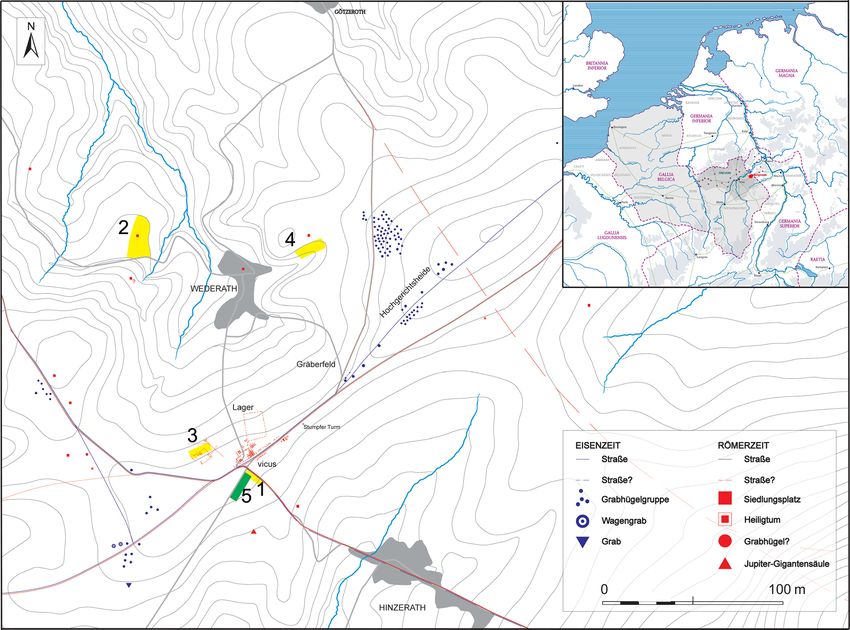
W.-R. Teegen et al.: Archaeological prospections in the Roman vicus Belginum 7
Figure 1. The archaeological site Wederath-Belginum during the Iron Age (Eisenzeit) and the Roman times (Römerzeit). Localization of
archaeological features, and the survey areas from 2004 to 2008 (1–4, yellow) and 2016 (5, green). Archaeological features are as follows.
Vicus: Roman vicus; Lager: Roman military camp; Gräberfeld: Celtic and Roman cemetery; “StumpferTurm”: medieval tower. Legend is as
follows. Straße: road; Grabhügelgruppe: group of tumuli; Wagengrab: wagon burial; Grab: burial; Siedlungsstelle: villa rustica; Heiligtum:
sanctuary; Jupiter-Gigantensäule: column of Jupiter and the Giants (map: Marco Schrickel, Jan König, Wolf-Rüdiger Teegen). The insert
shows a localization of the site Belginum (red) in the Roman province Gallia Belgica (map: Archaeological Park Belginum).
2.1.3 Prospection 2016 gether 2856 find locations were sampled containing a total
of 9979 finds.
In October 2016, a joint field exercise for 10–15 students
The aim of this prospection was to gather information
of (geo-)archaeology and geo-informatics organized by UT
about dating and material culture in this newly discovered
and LMU was carried out in the vicinity of Belginum in
western part of the settlement.
an agricultural field of approximately 1 ha in size located at
the southern side of the federal road B327 within the parish
Hundheim (Fig. 1 No. 5) (EV2016,205). 2.2 Data integration and analysis in GIS
During the first couple of days, the students surveyed The archaeological finds were inventoried and classified into
the field on a 1 m density grid. All non-local finds (pot- the general material groups pottery, bricks, roof slate, glass,
tery, bricks, glass, metal, etc.) were deposited into plastic and metal during another course at LMU. They were later
bags together with a unique identification code. These were recorded in an Excel spread sheet. In the consecutive GIS
then three-dimensionally sited by means of a total station exercise in 2017, these tables were integrated into an Ar-
(Leica) and a differential Global Navigation Satellite Sys- cGIS geodatabase, which required reorganization of the stan-
tem (GNSS) (TopconPositioning Systems, Inc.). As collected dard archaeological table structure into an appropriate geo-
fragments in 2016 were abundant, the finds of the site’s data format. The prospection areas of 2004 and 2016 partly
western part were sampled at 5 m × 5 m quadrants. All to- overlap at the north-northeastern region south of the federal
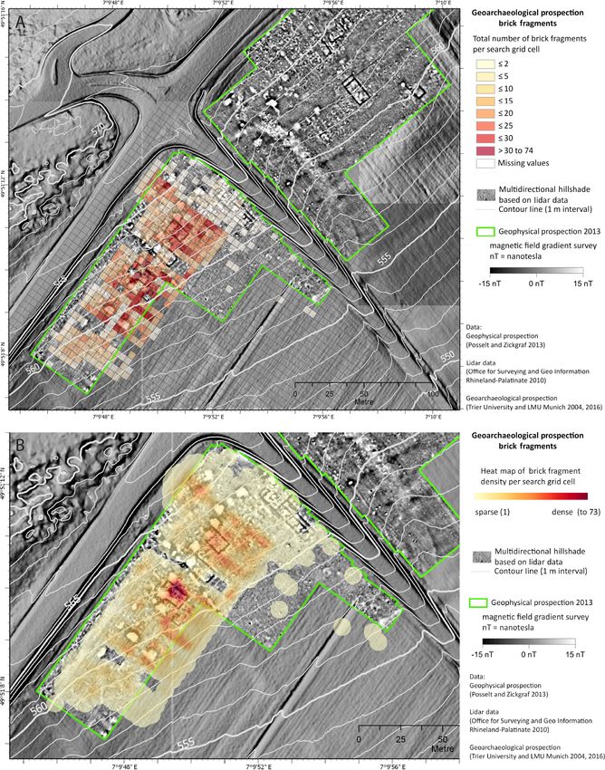
www.eg-quaternary-sci-j.net/68/5/2019/ E&G Quaternary Sci. J., 68, 5–11, 20198 W.-R. Teegen et al.: Archaeological prospections in the Roman vicus Belginum Figure 2. Wederath-Belginum, archaeological survey 2004, 2016. (a) Total number of brick fragments (1 to 74) per search grid cell (5 m × 5 m) in the western part of the vicus (GIS map: Johannes Stoffels). (b) Close-up of the heat map of brick fragments (1 to 74) per search grid cell (5 m × 5 m) in the western part of the vicus (GIS map: Johannes Stoffels). E&G Quaternary Sci. J., 68, 5–11, 2019 www.eg-quaternary-sci-j.net/68/5/2019/
W.-R. Teegen et al.: Archaeological prospections in the Roman vicus Belginum                                                            9

Figure 3. Wederath-Belginum, archaeological survey 2004, 2016. (a) Total number of pottery fragments (1 to 52) per search grid cell
(5 m × 5 m) in the western part of the vicus (GIS map: Johannes Stoffels). (b) Close-up of the heat map of pottery fragments (1 to 52) per
search grid cell (5 m × 5 m) in the western part of the vicus (GIS map: Johannes Stoffels).

www.eg-quaternary-sci-j.net/68/5/2019/                                                      E&G Quaternary Sci. J., 68, 5–11, 2019
10                                             W.-R. Teegen et al.: Archaeological prospections in the Roman vicus Belginum

road Hunsrückhöhenstraße B327 (see Fig. 1 No. 1 and 5).              geophysical information is available. Here, a reconstruction
The 3-D position data were projected to ETRS89/UTM32N                of the plots would be possible, using the density distributions
and archaeological attribute data were merged with the point         of bricks.
data for further find density analysis following Allen (2016),          Focussing on the density or heat maps of bricks within
exemplary for pottery and bricks. In concordance to the sam-         the houses (see Fig. 2), we can see a strong concentration of
pling, a regular fishnet of 5 m cells was generated and ori-         bricks within the houses. This is probably due to the fact that
ented to follow the study site orientation (SW–NE) as a              after leaving the houses at some point the roof truss collapsed
base for density mapping by summarizing finds for each re-           inwards (see Bentz, 2013, p. 78). As a result, the roof tiles
spective cell (Figs. 2a–3a). Finds were further described by         fell into the interior of the house. This is a quite different
kernel density maps (heat maps) visualizing the number of            mechanism compared to earthquakes, where walls generally
bricks or pottery fragments for a search grid cell of 5 m×5 m        collapse to the outside (Stiros, 1995, p. 729, Fig. 4).
(Figs. 2b–3b) (Silverman, 1986). Furthermore, the geomag-               From the excavations of the years 1969–1973 and 2000–
netic prospection, Rhineland-Palatinate’s lidar scans, and to-       2014 in the vicus Belginum, we know that the place was not
pographic raster maps were available. From the lidar eleva-          subject to a fire disaster, but had been abandoned. The de-
tion data, a multidirectional hillshade raster and contour lines     scriptions of the ruins of the vicus in the early 19th century
were derived at 5 m elevation intervals. The aim was (a) to          show that at that time some of the houses towered right up
explore the data and (b) to map and analyse the occurrence of        to the first floor (Merten in Cordie, 2007). In the middle and
material groups, which were also further analysed in a bach-         second half of the 19th century, stone and bricks were robbed
elor thesis at LMU (Over, 2018) using QGIS.                          for modern road and house construction and thus completed
                                                                     the destruction of the vicus. Today, not a single upright wall
                                                                     is present. However, part of the vicus must have already been
3    Results and interpretation                                      demolished in late antiquity. The new burgus, discovered
                                                                     during rescue excavations in 2015, clearly shows the walls
The classification and inventory of the finds during a course        were constructed with secondary building materials.
in winter 2016/17 at LMU revealed a dating in a time span               The distribution of the ceramic sherds shows a different
from the late first to the third centuries common era. This          pattern (Fig. 3). Here, the finds are concentrated in the rear
is consistent with the results of the 2004 prospection (see          part of some houses and in the backyard area. The major con-
above). During another course in winter 2018/19 at LMU,              centration of pottery is present in the rear part and in the
handmade pottery of the late Latène or early Roman period            backyard of three houses in the northern part of the survey
(second half of the first century before common era) was dis-        area (Fig. 3). From an archaeological perspective, this dis-
covered. This is the first indication for a late Latène (late pre-   tribution makes sense. When a Roman strip house is exca-
Roman) to early Roman settlement at Belginum itself.                 vated, the major quantity of (storing) vessels, glass, and other
   The data collected in the above-mentioned bachelor the-           household items will be discovered in the backyard. Here, the
ses (Over, 2018; Mägdefessel, 2018) were summarized in the           waste pits are usually localized. The waste pits were partly
overall mapping using ArcGIS (see Figs. 2–3).                        destroyed due to agricultural work in the last 2 centuries, and
   The geomagnetic prospection from 2013 (Posselt & Zick-            their contents came to light. The plowing activity might shift
graf) revealed several cellars and some houses south of the          ceramics and other finds downhill by about ≥ 5 m.
B327 (see Figs. 2–3). The width of the houses is mostly equal
to the plot widths. There is, however, sometimes a small
                                                                     4   Prospect
distance between the houses, as the excavations in the last
decades have shown (Cordie, 2007). Every house has a quad-           This work has shown that curricular practical course prospec-
rangular or rectangular cellar in its front part. The width of       tions bring further insights into settlement archeology. This
the cellars is sometimes equal to the house or plot widths. In       can be achieved with systematic field surveys, geophysi-
general, the cellars are smaller.                                    cal surveys, lidar scans, and aerial photographs obtained by
   The number of fragments per search grid cell and the ker-         plane, drone, or fixed-wing unmanned aerial vehicle.
nel density map of the bricks (Figs. 2–3) show a clear relation         The use of various archaeological and geophysical
to the single plots. The bricks are distributed from the cellars     prospection methods and the following GIS analyses brought
to the probable house extents up to the backyard area. This          a significant gain in knowledge for the site Belginum regard-
means a distance of 30 to 40 m. The finds concentrate in the         ing size and type of development – without excavation.
longitudinal axis of the plots. There is a decreasing intensity
of finds to the lateral periphery of the plots. The same distri-
bution may be observed for the adjacent plots. We can, there-        Data availability. For the next years, there is an ongoing project
fore, assume that the distribution of bricks mirrors the houses      regarding the spatial distribution of pre-Roman and Roman findings
on the single plots. This is quite an important result for fur-      in the vicus Belginum. This will result in some theses at LMU and
ther archaeological prospections on Roman sites, where no            UT. Furthermore, due to illegal activities of non-authorized detec-

E&G Quaternary Sci. J., 68, 5–11, 2019                                                    www.eg-quaternary-sci-j.net/68/5/2019/
W.-R. Teegen et al.: Archaeological prospections in the Roman vicus Belginum 11
torists, find co-ordinates will not be published. They will be, how- Cordie, R. (Ed.): 50 Jahre Ausgrabungen und Forschungen,
ever, stored in due course in the find archive of the Rheinisches Schriften des Archäologieparks Belginum 5, Philipp von Zabern,
Landesmuseum Trier. Mainz, Germany, 2007.
Cordie, R., König, J., and Teegen, W.-R.: Der vicus von Belginum.
Zum Stand seiner Erforschung, in: Neue Forschungen zu zivilen
Author contributions. RC and WRT organized the archaeologi- Kleinsiedlungen (vici) in den römischen Nordwest-Provinzen,
cal prospection, funding, and the identification of the findings. RR edited by: Heising, A., Akten der Tagung Lahr, 21–23 Octo-
and WRT were responsible for on-site data catchment. JS and RR ber 2010, Verlag Dr. Rudolf Habelt, Bonn, Germany, 101–118,
organized the GIS course and GIS analysis. JS, RR, SM, and PO 2013.
analysed GIS data. WRT and RC interpreted GIS data. WRT and Haffner, A. (Ed.): Gräber – Spiegel des Lebens, Schriftenreihe
RR wrote the paper with contributions from all co-authors. des Rheinischen Landesmuseums Trier 1, Philipp von Zabern,
Mainz, Germany, 1989.
Lukas, D., Teegen, W.-R., Cordie, R., Schrickel, M., König, J.,
Competing interests. The authors declare that they have no con- and Fleischer, F.: Auf der Suche nach den Kelten – Systema-
flict of interest. tische Prospektionen im Umkreis von Belginum, in: Die Eisen-
zeit zwischen Champagne und Rheintal, edited by: Schönfelder,
M. and Sievers, S., 34. Internationales Kolloquium der Associ-
ation Française pourl’Étude de l’âge du Fer, 13–16 May 2010,
Special issue statement. This article is part of the special issues
Aschaffenburg, Römisch-Germanisches Zentralmuseum, Mainz,
“Geoarchaeology and past human–environment interactions”. It is
263–290, 2012.
not associated with a conference.
Mägdefessel, S.: Eine GIS-gestützte Untersuchung von Prospek-
tionsfunden aus Wederath-Belginum (Kampagne 2004), BA the-
sis, Ludwig-Maximilians-University Munich, Germany, 41 pp.,
Acknowledgements. The work has been carried out using ESRI 2018.
ArcGIS and QGIS. Special thanks go to the students eagerly col- Over, P. M.: Zur Dokumentation, Visualisierung und Analyse
lecting fragments despite sometimes harsh weather conditions. Li- von Prospektionsfunden aus Wederath-Belginum, BA thesis,
dar and topographic map raster data (Basis-DLM) have kindly been Ludwig-Maximilians-University Munich, Germany, 116 pp.,
provided by Rhineland-Palatinate’s surveying office Vermessungs- 2018.
und Katasterverwaltung (topicality), 2014, 2015. The Archaeolog- QGIS Development Team: QGIS Geographic Information System.
ical Heritage of Rhineland-Palatinate at Trier (GDKE) kindly gave Open Source Geospatial Foundation Project, available at: http:
the necessary permissions. The group of students from Munich was //qgis.osgeo.org, last access: 17 December 2018.
gratefully supported by LMU and the local archaeological associa- Silverman, B. W.: Density estimation for statistics and data analysis,
tion (Förderverein Archäologiepark Belginum e.V.). For correcting Chapman and Hall, New York, USA, 1986.
the English in a previous version of the paper, we are grateful to Stiros, S. C.: Archaeological evidence of antiseismic constructions
Anneli O’Neill (LMU Munich). All remaining errors are, of course, in antiquity, Annali di Geofisica, 38, 725–736, 1995.
our own. Teegen, W.-R., Lukas, D., and Cordie, R.: Untersuchungen zur
eisenzeitlichen Besiedlung von Wederath/Belginum, Archaeol.
Mosellana, 9, 215–235, 2014.
References
Allen, D. W.: GIS Tutorial 2: Spatial Analysis Workbook (GIS Tu-
torials), 4th edn., ESRI Press, Redlands, USA, 2016.
Bentz, M.: Das Handwerkerviertel von Selinunt. Die Töpferwerk-
statt in der Insula S 16/17-E, Vorbericht zu den Kampagnen
2010–2012, Röm. Mitteil., 119, 69–98, 2013.
www.eg-quaternary-sci-j.net/68/5/2019/ E&G Quaternary Sci. J., 68, 5–11, 2019You can also read