Ardee Town Health Check - December 2018 Prepared on behalf of the Dee Hub and funded by the Department of Rural and Community Development under ...
←
→
Page content transcription
If your browser does not render page correctly, please read the page content below
Ardee Town
Health Check
Prepared on behalf of the Dee Hub and funded by the
Department of Rural and Community Development
under the Town and Village Renewal Scheme

December 2018
Contents
                                                                                 Introduction
1.   Introduction											3
2.   Methodology										4                                                      A local community organisation the Dee Hub based in the mid Louth area has commissioned this
                                                                                 health check assessment of the town of Ardee.
3.   Profile of the Area                                                    5
     3.1    County Louth Overview                                           5    The Health Check has been prepared to provide a “stock-take” of the current economic, social,
     3.2    Municipal District of Ardee                                     7    environmental and physical situation relating to the town in order to assess the vitality and via-
                                                                                 bility of the town centre. The assessment essentially analyses the strengths and weaknesses of a
     3.3    Profile of Town – Ardee                                         8    town and is based on a quantitative analysis of factors such as the range and quality of activities
     3.4    History & Heritage									8                                         in the centre, its mix of uses, its accessibility to people living in the area and its general amenity
                                                                                 appearance and safety. It involves consultation and input from various sources including the
     3.5    Places of interest                                              14
                                                                                 community, visitors and traders. Following a needs assessment, recommendations / actions have
     3.6    Education										18                                                been outlined and based on factual findings and community needs / inputs.
     3.7    Media                                                           19
                                                                                 This document will be made available to local groups and organisations to assist in the prepa-
     3.8    Transport                                                       19   ration of applications for funding from various public and EU co-financed programmes and ini-
     3.9    Sport                                                           19   tiatives and will provide an evidenced based foundation upon which future investments in the
                                                                                 village can be considered.
     3.10   Population										21
     3.11   Population Age Structure                                        23
     3.12   Households, Families and Children                               25
     3.13   Disadvantage, Affluence and Deprivation                         28
     3.14   Economic Demographics								31
     3.15   Social Class, Labour Force, Unemployment & Education in Ardee   32
     3.16   Employment Structure & Unemployment                             33
     3.17   Education                                                       38
     3.18   Commuting & Transport								41
4.   SWOT Analysis                                                          43
5.   Physical Survey Profile                                                44
     5.1    Ardee Premises Mix and Usage                                    44
     5.2    Accessibility and the Physical Environment                      46
6.   Public Consultation Findings                                           52
     6.1    Household Survey                                                52
     6.2    Business Survey                                                 68
     6.3    Community Survey                                                69
7.   Development Priorities                                                 75
     7.1    Community Infrastructure                                        75
     7.2    Economic Development                                            75
     7.3    Public Realm / Infrastructure / Environment                     75

2                                                                                                                                                                                    3
Methodology                                                                                           Profile of the Area
The health check in Ardee town was undertaken during the period September to December 2018.           County Louth Overview
The town centre for the purposes of the Health Check will be as defined in the County Devel-
opment Plan and/or the town of Ardee Local Area Plan. Census data was sourced from the 2016           The County of Louth is located in the North East area of Ireland. The total population in County
census figures. Other sources of data that were considered were SICAP data, Development/Local         Louth is 128,884 (CSO, 2016) which is an increase of 5,987 on the 2011 population. Louth is the sec-
Area Plans, LECP, and the Pobail Deprivation Index.                                                   ond most densely populated county in Ireland behind Dublin, due to its small size. The popula-
                                                                                                      tion of Louth increased by 4.5% between 2011 and 2016, with is over one percentage point greater
The town Health Check sought to identify existing assets, amenities, accessibility issues, environ-   than the increase in population recorded in the State as a whole (which was 3.8%). Louth accounts
mental quality, and retail mix and included;                                                          for 2.7% of the total population in the State.

    •   Basic Town Centre data,                                                                       The key population areas in County Louth are Dundalk, Drogheda, and Ardee. There are 43 EDs in
         • Population, socio economic profile and demographic                                         the county. Ardee Rural (2,952) and Urban (4,917) combined has a population of 7,869 according
         • Size, catchment (and catchment potential)                                                  to census 2016. This population growth occurred in 35 of the 43 Louth Electoral Divisions (EDs). Of
         • Economy, employment & retail                                                               the eight EDs that experienced a decline in population over this period included Dundalk Urban
         • Town centre uses, attractions, amenities vacancies etc.                                    No.2, No.4 and Faughart. Highest growth rates were generally in the south of the county and in
                                                                                                      areas within close proximity to major settlements. A total of 3 EDs increased their population by
    •   Town Centre Environment                                                                       more 15% during this period: Carlingford (22.2%), Darver (19.4%) and Dundalk No.3 (18.0 %).
         • Dereliction
         • Presentation of town centre – Observations and recommendations                             The All Island Research Observatory (AIRO) at the National College of Ireland Maynooth has
         • Infrastructure – Footpath, road, lights, streetscape and identification of minor infra-    mapped the electoral divisions (EDs) of Louth, based on census 2016 population data. The EDs
           structural deficiencies in access, services, and site development works etc.               with the highest population are indicated in dark blue on the map below.
         • Parking/traffic management considerations
         • Accessibility
         • Safety
         • Signage/way finding

    •   Economic
         • Business support and promotion initiatives
         • Business potential opportunities

    •   Tourism
         • Attractions and links to Irelands Ancient East
         • Enhancement of heritage
         • Accommodation
         • Signage/way finding

    •   Leisure, Recreation, Sport, Arts and Culture
         • Facilities
         • Events, activities, festivals.
         • Town centre amenities

A facilitated public consultation meeting and planning workshop took place in the Dee Hub build-
ing in Ardee on Wednesday 5th December at 7.30pm to secure the views of local residents, busi-
nesses and community organisations in relation to the priorities for the town in the coming years.
Three comprehensive online surveys were also conducted during November and December using                 Fig.1 Electoral Divisions of Louth Source: CSO Census 2016
Survey Monkey that was targeted at trader/businesses, local residents and community organisa-
tions. The surveys and public meeting were well supported with a representative sample of views
expressed and documented.

4                                                                                                                                                                                                       5
Table 1 below indicates the most populated EDs in the county, which together account for just          1991 and 2016, the population in the county increased by 42%, the 9th highest of all counties.
over half of the county’s population.                                                                  In the five years since Census 2011, population growth occurred in 36 of the 43 Louth Electoral
                                                                                                       Districts. The three electoral districts with the highest growth accounted for over a third of the
                                                                                                       population growth in the county: Dundalk Rural (19%), Fair Gate Drogheda (10%) and St. Peter’s
Table 1 Most Populated EDs (>4% population)
                                                                                                       Drogheda (10 %).

                                                          Pop.               % of County Total         Municipal District of Ardee

Dundalk Rural                                            19,265                            14.90%      Fig.2. Municipal District of Ardee

Fair Gate                                                10,424                              8.10%

St. Peter’s                                               9,721                              7.50%
Haggardstown                                              6,932                              5.40%

St. Mary’s (Part Urban)                                   6,859                              5.30%

West Gate                                                6,305                              4.90%
Dundalk Urban No. 4                                       6,130                             4.80%

Source: Figures extracted from CSO Census 2016

County Louth is the smallest of Ireland’s 32 counties in area (827 km2) and the 18th largest, in
terms of population. It is the smallest of 12 counties in Leinster in area, and the 6th largest in
terms of population based on Census 2016 data, yet it is the most densely populated county in
Ireland outside of Dublin with a population density of 156 people per km², more than double that
of the national average.

The largest towns in Louth are Drogheda and Dundalk, which is also the county town, a majority
of the population reside in the two towns and they account for 62% of all residents in the county.
Drogheda (40,956) is ranked as the sixth largest town in Ireland and Dundalk (39,004) is the eight
largest according to Census 2016.                                                                              Source: Figures extracted from CSO Census 2016

Despite being on the coast and its small size, Louth shares a border with three other counties,        Ardee is in the Municipal District of Ardee, along with the other towns in this health check, Dun-
Armagh to the north, Monaghan to the northwest and Meath to the southwest. With Dublin locat-          leer and Collon. These 3 settlements are situated in the southern half of the municipal district.
ed south of Meath, the southern part of the county feeds into part of the Dublin commuter belt.        There are 29,026 people living in the district, which is the largest municipal district in Louth, but
                                                                                                       the least populated.
Population Demographics Overview

With a population of 128,884, Louth has the 18th highest population of all counties in the State.
Census 2016 shows an increase of 4.9% from the previous census compared to an increase of
3.8% at State level. This was an actual increase of 5,987 people. This makes Louth proportionally
the ninth fastest growing county in the State. Despite the population growing by 4.9% the pro-
portion of households in the county grew by a lesser 3.5% over the same time. Net migration has
decreased by -1 per 1,000; the natural increase is now 8.91 per 1,000, this natural increase was the
11th highest of all local authorities in the State.

The spatial distribution of the population within Louth is as follows: two thirds of the total pop-
ulation live in the three largest towns, Drogheda (32%), Dundalk (30%) and Ardee (4%). Louth has
experienced a major and consistent expansion of its population in recent years. This expansion is
the result of both a high birth rate and high levels of inward migration into the county. Between

6                                                                                                              Fig. 3. Location map of Ardee town Source: Map Data 2018 Google Maps                       7
Profile of Town – Ardee                                                                               Historic buildings
Ardee (Irish: Baile Átha Fhirdhia, meaning “townland of Ferdia’s ford”) is a town and townland        Ardee Castle
in County Louth, Ireland. It is located at the intersection of the N2, N52, and N33 roads. Ardee is
the principal town and population centre for mid-Louth and the Municipal District of Ardee. It is                                                         Ardee Castle also known as St. Leger’s Cas-
a well-established and successful local service, shopping and employment centre for both the                                                              tle, is a fortified medieval tower house. Built
town’s population and an extensive hinterland, serving much of mid-Louth and neighbouring ar-                                                             in the 15th century, the castle was used as a
eas of County Meath. Its appeal primarily stems from the wide range of independent retailers, a                                                           prison during the 17th and 18th centuries and
choice of bars and restaurants, its built and natural environment and location on the intersection                                                        became Ardee’s district courthouse until June
of the N2 Dublin – Derry Route and N52 Ardee – Nenagh Route and its proximity to the M1.                                                                  2006 when a specialized facility took its place,
                                                                                                                                                          in the new Mid-Louth Civic Services complex
Ardee has expanded significantly over recent years, from a population of 3,568 in 2002 to an esti-                                                        at the Fair Green. Ardee Castle is the largest
mated population of over 5,000 in 2018. The largest growth happened from 2002 to 2010 with an                                                             fortified medieval Tower House in Ireland or
increase of roughly a thousand. This has been largely driven by car-borne residential commuter                                                            Britain. The castle was originally built by Rog-
development, given the easy accessibility of Ardee to Dublin, Drogheda and Dundalk by road. This                                                          er de Peppard in 1207, but not much is left
has resulted in substantial residential development mostly towards the southern part of the town                                                          from the original walls.
which includes Stoney Lane, Clonmore and Moorehall Rise. Between the years 1998 and 2003 in
excess of 1,000 residential units were granted planning permission. During the 2003 - 2009 Plan                                                           The rectangular building stands four storeys
period permission was granted for in excess of 400 additional residential units.                                                                          high. with turrets situated at the north-west
                                                                                                                                                          and south-west angles, the main entrance
Ardee is on the banks of the River Dee and is equidistant between the county’s two biggest towns      was protected by a machicolation on the outside, with a ‘murder-hole’ on the interior. The ground
- approximately 20 km (12 mi) from Dundalk and Drogheda, while it is also close to Slane and Car-     floor has a rounded barrel vault, and access to the upper storeys is by means of a stairway in the
rickmacross. The deteriorating economic climate that has emerged from 2008 onwards has had            north-west turret. As the structure has remained in continuous use, most of the windows have
serious implications for employment in Ardee. This has been reflected in the increasing number        been replaced and modernized over time, however a twin-light ogee-arched window survives at
of vacant units in the town centre. Vacant units, together with traffic congestion have combined to   ground level and three single looped, internal splay windows survive on the fourth floor.
undermine the appeal of the town centre. If Ardee is to remain a successful centre for residents,
shoppers, businesses and visitors alike it is important that these issues are addressed.              St. Leger’s Castle was built in the 15th century by John St. Leger and it served as a stronghold for
                                                                                                      the defense of the Pale. Over the years it was fought over by the O’Neills and the English and
History & Heritage                                                                                    was even used by James II as his headquarters prior to the Battle of the Boyne. In 1641 Sir Phelim
                                                                                                      O’Neil took possession of the town and set up the Irish Army headquarters, but on the retreat the
Town origins

Originally called Atherdee, the towns name is from the Irish Áth Fhirdia (the Ford of Ferdia) which
itself is derived from the fabled four-day battle between Cúchulainn and Ferdia, for the defence
of Ulster from Queen Maeve of Connacht. It is said Ferdia fell after four days of battle and is
buried on the southern banks of the river alongside the riverside walk. A depiction of the pair is
located on Bridge Street in the town as a bronze statue.

Ardee is a prime example of a medieval ‘walled town’, many of which can be found across Ireland.
With its distinctive, central Main Street and long narrow properties extending away from the main
street on either side, it holds many of the properties associated with “walled towns”. The town
itself is situated in the southern part of the ancient territory known as the Plain of Muirheimhne.
The town lies along the 15th century Pale frontier between Dundalk and Kells.

The town centre shows evidence of development from the thirteenth century onwards. Today the
town has a busy centre with many shops, services, bars and restaurants trading along its main
street. As a result of continued development, much of the fabric of the medieval town has been
removed and now lies beneath ground level. Nevertheless, the surviving monuments are both
spectacular and unusual, notably Ardee Castle and the intact medieval street pattern.

8                                                                                                                                                                                                       9
Fig.4. Outline map of Ardee, showing town defences and location of sites referred to in text (Bradley, 1984).

                                                                                                                                                                                Ardee was besieged and captured on
                                                                                                                                                                                three occasions. In 1315 it was taken
                                                                                                                                                                                by Edward Bruce; it fell to Conn O’Neill
                                                                                                                                                                                and Manus O’Donnell in 1539; and Sir
                                                                                                                                                                                Phelim O’Neill captured it in 1641. The
                                                                                                                                                                                town was defended by walls, which
                                                                                                                                                                                enclosed over 25 hectares (60 acres)
                                                                                                                                                                                by the seventeenth century. There
                                                                                                                                                                                is now little trace of the town walls
Natural fording points on rivers are important for transport                                                                                                                    above ground, but their rectangular
and communication and have a strategic value. The river-                                                                                                                        plan can be determined through the
side location and the presence of a natural fording point                                                                                                                       use of early maps.
were among the reasons for the establishment of a town
here. Its location on the river Dee was significant through-                                                                                                          Outside the walls on the north was a
out prehistory, with some evidence indicative of Mesolithic                                                                                                           suburb at Irish Street. The early maps
activity close to the town and its environs. There is no indi-                                         show that there were six gates. The Head Gate stood at the top of Market Street; another gate
cation of the date of the first bridge at Ardee, but it is likely                                      further to the north on Irish Street was known as the North Gate, suggesting that the extramural
that the original bridge would have been wooden. There                                                 suburb had its own defensive wall projecting off the original town wall. Cappock’s Gate provid-
are references to repairs to a stone-built bridge being organised in the early fourteenth century,     ed access from the east. On the south, access via the bridge was provided by Bridge Gate on the
when it is likely that a gate would have defended the town on the north bank of the river.             northern side of the river. On the west there were two gates, the Blind Gate and the Ash Walk Gate.
                                                                                                       Regrettably, none of the gates survive. North of the Ash Walk Gate there is a projection outward
Richardson’s map of 1677 depicts a three-arched bridge at this location. An indication that Ardee      in the town wall known as the Bastion. This feature would appear to be a seventeenth-century
may have had more than one bridge is indicated by a reference to a grant by the archbishop of          artillery fortification providing protection against attack from the west.
Armagh of an indulgence of 40 days to all who contributed to the repair of the bridges at Ardee.
The present bridge appears to be of eighteenth-century origin.                                         St Mary’s

                                                                                                                                                                        A church had been established in Ardee be-
Town walls and street plan                                                                                                                                              fore 1197. In 1315 it is recorded that Edward
                                                                                                                                                                        Bruce had burned ‘the church of St Mary
The principal access and egress through Ardee is the wide, north/south-running Market Street and                                                                        the Virgin, full of men, women and children’.
Castle Street, circa 800m long. Like many other medieval towns, Ardee appears to have developed                                                                         The surviving structure of St Mary’s Church
around a market-place. John Bradley, the renowned Archaeologist and Historian from Kilkenny,                                                                            incorporates three phases of building with-
remarked that Market Street is first mentioned as Main Street in 1344, and it would appear that                                                                         in it — the fifteenth-century church, a six-
the cross that stands outside St Mary’s may have been located here, replacing a wooden market                                                                           teenth-century addition and the present
cross that formerly occupied that location. Houses would have lined either side of the street, with                                                                     nineteenth-century church.
their burgage plots extending to their rear. Other than the castles described below, little is known
of the early houses in Ardee. Small streets and lanes would have occurred at intervals to the right                                                          The present nineteenth-century façade on
and left of the main street, giving access to the rear of the properties.                                                                                    the west side is an impressive construction,
                                                                                                                                                             with a blank elevation on the north which
                                                                                                                                                             appears to be an attempt to mark the po-
                                                                                                       sition and layout of the no-longer-upstanding medieval northern aisle. The medieval southern
                                                                                                       aisle is incorporated into the early nineteenth-century building and is separated from the nave
                                                                                                       by four pointed arches supported on octagonal piers with moulded capitals. The chancel, extend-
                                                                                                       ing from the east end of the nave, is considered to be a sixteenth-century addition, although the
                                                                                                       heavy render covering the building makes it difficult to appreciate.

10                                                                                                                                                                                                                     11
Medieval cross fragment                                                                                  Chantry College

                      A fragment of a disc-headed cross, likely to date from the mid-sixteenth                                                    Located to the east of St Mary’s, outside the present
                      century, stands in front of the façade north of the entrance to the church.                                                 graveyard wall, is an unusual medieval building known
                      This may be the remains of a cross that once stood in Ardee’s marketplace.                                                  locally as ‘the college’. It was formerly used as the res-
                      The surviving limestone fragment has been re-erected on a concrete shaft                                                    idence for chaplains to St Mary’s and was occupied by
                      and base. The west face of the cross bears a representation of the Crucifix-                                                the church Sexton as recently as 1875. The simplicity of
                      ion under a canopy, while the east face shows a representation of the Virgin                                                the building belies its significance. Historian and ar-
                      and Child under an ogee-headed canopy. The north arm bears a slightly                                                       chaeologist Noel Ross has pointed out that a chantry
                      damaged IHS inscription in false relief.                                                                                    is an endowment for the maintenance of priests to sing
                                                                                                                                                  masses, usually for the founder.
                                                                                                                                                  He further states that the Ardee chantry college is
                                                                                                                                                  unique in County Louth. While there are other known
The Courthouse                                                                                                                                    chantries in places such as Dundalk, Termonfeckin and
                                                                                                                                                  Drogheda, the chantry college in Ardee was built specif-
                                      Located on the east side of Castle Street, this building ranks                                              ically to allow chaplains to live in common.
                                      as the largest fortified town house to survive in Ireland. The
                                      mass of its masonry makes it the most noticeable of the            Constructed with high-pointed gables on the east and west sides, the original building had four
                                      remains of the medieval town of Ardee. Dating from the fif-        floors. The walls are constructed of rough-coursed masonry with limestone quoins. The original
                                      teenth century, this structure was previously known as ‘Ar-        entrance to the building was by means of a pointed doorway on the north-west, where there was
                                      dee Castle’, ‘St Leger’s Castle’ and ‘Pipard’s Castle’. Today it   a vault over the ground floor. The internal space on the ground floor measures 6.4m by 4.3m. It is
                                      is more commonly referred to as the Courthouse.                    unclear how the upper storeys were accessed from the ground, but Bradley suggested that there
                                      Rectangular in plan, with projecting turrets at the north-         may have been a wooden staircase on the exterior of the north wall. On the first floor there is an
                                      west and south-west angles, the building stands four sto-          opening that may be a flat-headed window and another that may have been a doorway. A further
                                      reys high. The original entrance to the tower was through a        opening on the east wall appears to be a blocked fireplace with a flue that continues through the
pointed-arched doorway in the north-west angle. The door was protected by a machicolation on             gable of the second floor. The top floor appears to have accommodated a loft.
the outside, with a ‘murder-hole’ on the interior.
                                                                                                         Carmelite Friary and Hospital of St John the Baptist
The ground floor has a rounded barrel vault, and access to the upper storeys is by means of a
stairway in the north-west turret. The structure has been in continuous use, with most of the
windows being replaced and modernised over time. A twin-light ogee-headed window survives                Two important sites known to exist at Ardee are no longer identifiable. The Carmelite Friary is
at ground level, however, while three original windows — single loops with an internal splay—sur-        thought to have been founded by Ralph Pipard in 1302. It is likely that the building was of sub-
vive on the fourth floor.                                                                                stantial proportions, as it accommodated the meetings of several provincial Carmelite chapters
                                                                                                         during the fourteenth century. Richardson’s map of 1677 indicates that its location is most likely
                                                                                                         to have been near the river and within the southern end of the town wall on the east.

Hatch’s Castle                                                                                           The Hospital of St John the Baptist, founded by Roger Pipard circa 1207, is likely to have been
                                        This building is a smaller, four-storey town house fronting      located outside the town walls on the southern side of the river. The name John Street may pre-
                                        onto Market Street, a continuation of Castle Street, 200m        serve an association with the precinct of the hospital at this location not far from Moore Hall.
                                        north of the Courthouse. It is currently inhabited as a pri-     Richardson’s map shows a church at this location, south of the river and to the east of the bridge.
                                        vate residence. It is known as Hatch’s Castle, after the Hatch   Human remains have been discovered in this area in recent years, possibly reinforcing the loca-
                                        family who occupied it in the eighteenth century. There are      tion as the burial ground of the hospital.
                                        four floors, with a wall-walk and turret above. The ground-
                                        floor plan is roughly rectangular, with semicircular turrets     Motte and bailey
                                        projecting outwards at the eastern corners. The most likely      The remains of a motte and bailey provide some of the earliest evidence for an Anglo-Norman
                                        location for the original entrance is on the west, where the     presence at Ardee. It is likely that the motte would have been constructed around 1185, when
                                        modern entrance is located.                                      Prince John granted the barony of Ardee to Gilbert Pipard. The motte, known as the Castle Guard
                                                                                                         or Dawson’s Moat, is located on the eastern outskirts of Ardee on the south side of the river,
                                                                                                         circa 900m from the present bridge. The mound that forms the motte, on top of which a wooden
                                                                                                         castle would have been erected, stands over 9m high, with a diameter of 60m at the base and a
                                                                                                         flat top measuring 16.4m across. It is likely that the bailey would have been located on the north
                                                                                                         side, but it has been levelled along with the banks and ditches that would have surrounded the
                                                                                                         motte itself.
12                                                                                                                                                                                                        13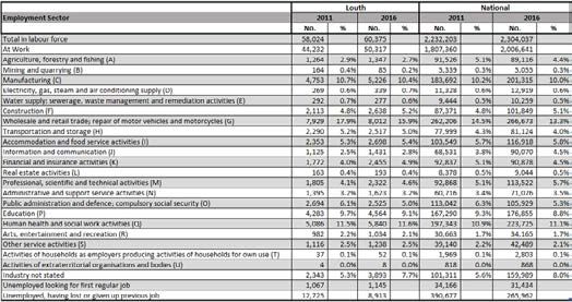
Ardee is home to many more historic buildings and structures, including Kildemock’s Jumping            Nativity of Our Lady Church
Church, St Joseph’s Hospital and the Convent of Mercy. The ruins of the Jumping Church of Kil-
demock formally known as Millockstown Church is a tourist attraction in Ardee which claims to be
an “unsolved mystery.” Myth has it that a non-Christian was buried inside the Church walls, and
that later that night the Church jumped to leave his remains outside of the sacred ground.

Smith schools

A philanthropic trust founded by Erasmus Smith in the 17th century funded the establishment of
a boys’ school in 1806 and a girls’ school in 1817. Both Protestant and Catholic children were al-
lowed to attend. At the time there were other schools but in 1824 they became the sole schools in
the area. The Smith schools amalgamated into a combined-sex establishment by 1858, by which
time the National School movement was leading to the creation of denominational schools there.
The school remained a non-denominational institute, but the school decreased in numbers and
in 1868 had a roll of only 16 Protestant boys. It was fully integrated into the National School sys-
tem in 1954, when it became known as Saint Mary’s Church of Ireland National School.

Places of interest

Nativity of Our Lady Church

                                                           This distinctive post-Vatican II church,
                                                           designed by Guy Moloney and Associ-
                                                           ates, is a detached multi-bay Roman
                                                           Catholic church, built in 1974. Octag-
                                                           onal plan, flat-roofed main entrance
                                                           to east with cantilevered canopy, with
                                                           secondary entrances to north, south
                                                           and west.

                                                                                                       Market Square is just off Market Street and includes the Sir Frederick Foster Memorial and Ardee
                                                                                                       Library. The memorial is a freestanding stone monument, erected 1861. This monument, designed
                                                                                                       by architect John Murray, was erected to the memory of “one of the best landlords that ever lived”
                                                                                                       and placed in such a prominent position within the town of Ardee because of the respect with
Nativity of Our Lady Church                                                                            which Sir Frederick Foster was held by his tenants.

                                                The Mercy Convent is an attached five-bay
                                                two-storey stone convent school, built circa 1855,
                                                no longer in use as school, now used as convent.
                                                This fine building is an integral part of the Mercy
                                                Convent complex and contributes to the quality
                                                of the group particularly with its tall stepped tow-
                                                er. Designed by John Neville, the Gothic Revival
                                                detailing and adoption of high-quality masonry
                                                and other materials add to the artistic interest.
                                                Formerly used as a primary school. the building
                                                played a vital role in the local community.

14                                                                                                                                                                                                     15
Fair Green and Helmet Monument, Irish Street                                                        St Brigid’s Hospital in Ardee has been in operation for 82 years and has provided mental health
                                                                                                    services for patients from all across Co. Louth during that time.

                                                                                                    St Joseph’s Hospital, Ardee

                                                                                                                                          St Joseph’s Hospital is a detached seven-bay three-storey
                                                                                                                                          over basement former house, built circa 1780. This large clas-
                                                                                                                                          sically-styled hospital and chapel work together to create a
                                                                                                                                          commanding presence on the west side of Ardee. Although
                                                                                                                                          much altered, the west elevation of the former house, built
                                                                                                                                          for the Ruxton family, retains its original proportions and
                                                                                                                                          details and a fine entrance porch.

                                                                                                                                          The chapel is a pleasant little building with some nota-
                                                                                                                                          ble details such as the simple open porch with excellent
                                                                                                                                          wrought-iron gates. Views over open countryside to the
                                                                                                                                          west enhance the wooded setting.

The Fair Green is today a public park, bounded by the Carrick Road and Golf Links Road. Fair        Bohemian Centre, Jervis Street, Ardee
greens often developed in Irish towns as informal spaces outside the town core. The triangular
green can be seen on Wren’s map of 1766 and in more detail in the nineteenth century maps,          This building is owned by the Ardee Concert Band and the hall is available to rent for events.
situated just outside the North or Irish Gate, between converging routes leading out into the       Founded in 1860, Ardee Concert Band is the third oldest concert band in Ireland. In just over 150
rural hinterland. This space is an important location marking the entrance to the urban core and    years in operation, they have achieved much and received wide acclaim in Ardee, Louth and be-
demonstrating the historical evolution of the town. It is bounded on the south side by the de-      yond. Throughout the years, while periodic declines have been inevitable, the band has remained
mesne wall and entrance to Ardee Demesne, the demesne trees strongly marking the presence           together and developed to become one of the more sought-after concert bands in the country,
of the park landscape beyond.                                                                       winning regional and national titles and performing at Croke Park as early as the 1950s, under the
                                                                                                    directorship of Paddy O’Brien.
A two-storey terrace continuing the line of the demesne wall presents an urban elevation to the
approach from the north and west. The boundary of the Fair Green itself is marked with large        In 1979, they performed at Killineer during the visit of Pope John Paul II. Since then, more compe-
mature trees which determine the mature character of the park.                                      tition wins and high placings have followed for the Band, its Youth Band and individuals.
St Brigid’s Hospital, Kells Road, Ardee
                                                                                                    Based in the Bohemian Centre Ardee, the group performs annually in the Ardee St Patrick’s Day
                                                                                                    parade and at their own Annual Concert every December and annual Spring Concert. In 2016
                                                                                                    alone, the band won the Turner Cup in the North of Ireland Band Association competition and
                                                                                                    also won the corresponding prize at the South of Ireland Band Championships in Clonakilty, Co.
                                                                                                    Cork.

                                                                                                    In April 2017, the seniors won ‘Best Own Choice’ award at the 51st annual IABCB National Bands
                                                                                                    Championships in Navan, whilst also taking home the second-place award. In addition, two mem-
                                                                                                    bers won at the Annual Irish Association of Brass & Concert Bands Solo and Ensemble competi-
                                                                                                    tion. Aisling Reilly won the Open Section of the competition, while Cathal Flanaghan took home
                                                                                                    the award for the Under 18 section.

                                                                                                    Dee Hub Centre, Market Street, Ardee

St Brigid’s Hospital is a detached multiple-bay two-storey hospital, built in 1933. Designed by     The Dee Hub is a not-for-profit organisation set up to establish a Youth and Community Resource
architect H.T. Wright, this sprawling hospital complex is the dominant feature in the country-      Hub in Ardee. Providing programmes and services to address the needs of all young people,
side to the west of Ardee. The symmetrically disposed two-storey flat roofed ward blocks frame      adults and families in the area, particularly those at risk of disadvantage and social exclusion,
the classically-inspired main entrance building set in front of a tall copper roofed clock tower.   and support them to live empowering lives. The vision of the Dee Hub is that all young people,
Viewed from the south the entrance block is framed by evergreen trees. The brickwork is relieved    adults and families, in Ardee and the surrounding areas, have access to a safe, creative and dy-
by surface modulation and the stone entrance door case displays excellent craftsmanship in its      namic Community Resource Hub that is a source of empowerment in their lives.
execution.

16                                                                                                                                                                                                    17
The DeeHub was established in 2014. In 2014 an Interagency group came together which included           was officially opened in 2007 with enhanced facilities opened in 2018. Work was completed on a
local people and representatives from some agencies such as HSE, LMETB, and An Garda Siocha-            secondary for Ardee CS that will increase its capacity to around 900 pupils.
na to look at the need for a space and services to support the community and families in Ardee
and the surrounding Mid-Louth region, particularly those at risk of social exclusion. In 2014, the      There are three primary schools located in the town: Monastery Boys National School, Scoil Mhuire
Dee Hub group carried out a Needs Analysis survey of 170 people on key issues in Ardee. The top         na Trocaire Girls School and Ardee Educate Together. Ardee Educate Together is a multi-cultural
need identified was for a community space in the town, including a place for young people. In           primary school for both girls and boys. Ballapousta National School is located just outside the
2015/2016 an external organisational consultant came on board to facilitate a consultation pro-         town and currently has just under 250 pupils. The Boys School currently has 267 pupils enrolled
cess with key stakeholders and develop a draft Strategic Plan. The process included two public          while the Girls School and the Educate Together School have 261 and 124 pupils respectively.
meetings and the setting up of an Interagency Committee.
                                                                                                        Media
Smarmore Castle, Ardee                                                                                  Newspapers include the Mid-Louth Independent, a regional edition of the Drogheda Indepen-
                          Smarmore Castle is an Irish medieval castle located 5km south of Ard-         dent newspaper, which is published weekly. It is distributed and sold in Ardee, Collon, Dunleer
                          ee. Smarmore Castle was first officially mentioned in 1320 as the seat        and Tallanstown. The Dundalk Democrat is the regional edition of the weekly newspaper, which
                          of the Taaffe family. The Taaffe family, originating from Britain, lived in   covers Ardee and its surrounds. LMFM Radio is the local radio station for the North East covering
                          Smarmore Castle up to the 1980s. While the tower house was built in           Ardee as well as the rest of Louth, Meath, and North Dublin. LMFM broadcasts mainly on 95.8FM
                          around 1320, other buildings of the castles were established between          or 95.5FM but its broadcasts are also streamed online.
                          1730 and 1750. After the Taaffe family sold the castle it was converted
                          into a guest house.                                                           Ardee previously had a local website called “ThisIsArdee” that would describe local happenings
                                                                                                        and broadcast news from the Louth area that was quite popular. However, while it was popular
                          In 2015, Castle Craig, a British Addiction Treatment Centre, acquired         locally the low take-up of its crowd funding campaign contributed to a decision to cease publica-
                          Smarmore Castle. The Smarmore Castle Private Clinic, a drug and alco-         tion as well as the work being time consuming and expensive.
                          hol treatment centre, opened in 2016. The name Smarmore has its ori-
                          gins in an Irish language legend known as Táin Bó Cúailnge (The Cattle
                                                                                                        Transport
                          Raid of Cooley).                                                              Ardee Railway station, previously serving the town, was linked to the main Belfast-Dublin railway
                                                                                                        line at Dromin Junction station, along a five-mile-long (8 km) branch line. The Ardee Railway sta-
Jumping Church, Kildemock, Ardee                                                                        tion opened on 1 August 1896 and passenger services ended on 3 June 1934. The line continued
                                                                                                        as a freight service until it finally closed on 3 November, 1976, serving the local fertilizer factory,
                                This heritage place is located 4km south of Ardee. It is believed Di-   sugar beet and livestock transport. The trackbed was lifted in the late 1980s, and much of the
                                omoc, a disciple of St. Patrick and St. Benen, founded this church.     short route is now a designated walkway. Ardee’s transport network consists of the N2, which runs
                                By c.1270 it was in the ownership of the Knights Templars of Kilsa-     directly through the town, and the M1 motorway, which is connected to Ardee through a bypass /
                                ran. They dedicated the church to St. Catherine. The Knights Tem-       linkroad.
                                plars held it until the suppression of their order in 1314. It then
                                passed to the Knights Hospitallers until they were suppressed by
                                                                                                        Sport
                                Henry VIII in 1540.                                                     Soccer

                                 The church is more famously known as the ‘Jumping Church’. The         Ardee is the home of two soccer clubs who currently play in the North East Football League (for-
                                 west gable wall of the church has jumped inward a few feet from        merly MDL) - Square United and Ardee Celtic. In 2016, Square United celebrated their 40th year in
                                 its foundations. This is believed to have happened in February         existence. Ardee Celtic’s first team is currently managed by Niall Taaffee, Conor Lynch and former
1715 during a storm. According to legend, the west gable of the building jumped two feet inside         Drogheda United boss Paul Lumsden while two ex-LOI footballers have turned out for Square
the wall of the original foundation to exclude an excommunicated church member who had been             United - Alan Doherty and Ross Gaynor. Both teams have junior sections that cater for very young
buried in the church. The ruin dates back to the 14th century, though the site also contains            players all of the way up to Under 18 level. In 2015, Ardee Celtic announced a community part-
                                                                                                        nership with English Premier League side Crystal Palace while Square have a similar link-up with
Education                                                                                               Everton FC.
Ardee today has only one secondary school called Ardee Community School. The school opened
in 1974 and in 2014 celebrated its 40th year. The school is an amalgamation of three schools that       Former Ardee Community School and Ardee St Marys man Ryan Rooney currently plays college
had previously existed independently- St. Anne’s Convent of Mercy, De La Salle Brothers’ School         football for St. Rose of Albany USA after attaining a scholarship there in 2014. In November 2016
and the Vocational School. It currently has a student body of around 750. Alumni include MEP            Rooney was named on the All East conference team of the year, scoring a total of thirteen goals
Mairead McGuinness, Irish Independent soccer correspondent Daniel McDonnell, the Irish Times
political reporter Sarah Bardon and former Republic of Ireland Under 21 footballer Ross Gaynor.
Among the facilities at Ardee Community School is the first Autistic Unit in Co. Louth. The room

18                                                                                                                                                                                                           19
Local footballer Ross Gaynor has represented the Republic of Ireland Under 21 team at interna- Concert Band are joined by commercial and community floats and novelty floats too. Every year, a
tional level and after returning to Ireland after a spell in England with Football League side Mill- local person is bestowed the honour of Grand Marshal of the parade - while dignitaries and local
wall, he has played for Cobh Ramblers, Drogheda United, Dundalk, Sligo Rovers and Cork City. He elected representatives are also invited to attend.
currently plays for NIFL side Linfield. While at Sligo Rovers, Gaynor won a League of Ireland league
title, a Setanta Sports Cup and a FAI Cup. Arts and festivals
GAA Founded in 1860, Ardee Concert Band is the third oldest concert band in Ireland. Ardee also has
an annual St Patrick’s Parade on March 17. The first parade began in Ardee in 1962 and has run ev-
Ardee St Marys is the main GAA team in Ardee. The Blues are one of Louth’s most successful se- ery year since then, except for 2001 due to the foot-and-mouth crisis. Local bands such as Ardee
nior GAA sides with 11 Senior Championship wins in their history - the first in 1914 and the most Concert Band are joined by commercial and community floats and novelty floats too. Every year, a
recent in 1995. St. Marys reached the 2016 Louth Senior Football Final for the first time since 2003, local person is bestowed the honour of Grand Marshal of the parade - while dignitaries and local
however, they were narrowly defeated by Sean O’Mahonys of Dundalk on a scoreline of 1-11 to 1-9 elected representatives are also invited to attend.
with Mark Fay scoring the Marys only goal of the game and finishing with 1-1.
Since 2004, the town has hosted the Ardee Baroque Festival at various locations throughout Ard-
There are five other GAA sides that operate in Ardee’s hinterland - Hunterstown Rovers, Westerns ee. The annual two-day event sees visitors travel from across the country and afar to take in some
GFC, John Mitchels, Sean McDermotts and Stabannon Parnells. Louth GAA legend Stephen Melia of the works of known composers and the other events taking place over the weekend. The Irish
began his career with the John Mitchels in the 1980s. Hunterstown Rovers are twice Louth Inter- Baroque Orchestra headline the event every year.
mediate Champions and they have won the Louth Junior Football Championship four times, most
recently in 2013. Hunterstown celebrated 75 years in existence in 2016 while in 2017, John Mitchels A new festival for Ardee was launched in 2009 titled the “Turfman Festival”. It was held on the
GFC celebrate their 60th year since foundation. August bank holiday weekend with numerous community events including a Festival Queen com-
petition, tuft footing, and events happening on the street and in local venues from live music to
As of January 2016, Ardee St Marys’ John Bingham and Ronan Carroll, Hunterstown’s Ryan Burns, face painting, art exhibitions and talks to a popular town-wide pub quiz. The last festival was held
Tony McKenna and David Finn and Westerns’ Tommy Durnin were in Colm Kelly’s Louth Senior in 2013.
football panel for the O’Byrne Cup. Bingham, Burns and Durnin retained their places for the
league campaign. In 2017, Ardee hosted the Association of Irish Floral Artists National Flower Festival. Taking place
at Ardee Parish Centre, St Mary’s Church of Ireland and the Church of the Nativity of Our Lady, the
In 2012, Ardee Community School’s Senior gaelic football team, under Mark Gilsenan, made histo- festival’s theme in 2017 was Celtic Way.
ry by becoming the first Ardee team to win the Lennon cup, defeating St. Mary’s of Drogheda on
scoreline of 4-11 to 0-7. The following year Ardee made it back to back Lennon cup victories, de- Dermot O’Brien is Ardee’s most musical son. In the 1960s, Dermot’s band The Clubmen reached
feating the Marist of Dundalk in a replay. History was again made in 2014 as the team reached the the top of the Irish singles chart with “The Merry Ploughboy”. Later in the decade, Dermot starred
All Ireland ‘C’ final but were defeated by Coláiste Ghobnatan of Cork on a scoreline of 1-12 to 2-6 in his own RTE show The Styles of O’Brien.
Rugby Population
The town has one rugby club - Ardee Rugby Club which has a first and second senior team and The population of Ardee can be geographically categorised into the town settlement boundary
several juvenile teams at various age levels for boys and girls. In 2015, Ardee Rugby Club won the and the Electoral Divisions (ED). Ardee has 2 district electoral divisions, Ardee Urban ED and Ardee
McGee Cup and their youth sides picked up both the Under 15 and Under 17 North East Shield. Rural ED. Fig. 5 illustrates a map of these 2 districts with the town settlement and their respective
population sizes.
There are several other sporting groups in Ardee including Ardee Cycling Club and Ardee & District
Athletics Club as well as tennis and badminton groups.
Archery
There are currently two archery clubs operating in Ardee - Cuchulainn Archers and Ardee Archery
Club. In 1908, Ardee-born Beatrice Hill-Lowe became the first Irishwoman ever to win an Olympic
medal, taking home bronze for archery at the 1908 Olympic Games. She represented Great Britain.
Arts and festivals
Founded in 1860, Ardee Concert Band is the third oldest concert band in Ireland. Ardee also has
an annual St Patrick’s Parade on March 17. The first parade began in Ardee in 1962 and has run ev-
ery year since then, except for 2001 due to the foot-and-mouth crisis. Local bands such as Ardee
20 21Fig.5: Ardee Electoral Divisions and Town Settlement 2011 and 2016 Population Table 2 Ardee Town, County Louth, Border and State Population Change 2002 - 2016
Source: Figures extracted from CSO Census 1991, 1996,2002,2006, 2011 & 2016
Table 3 Ardee Town DEDs, County Louth Population 1991 - 2016
Source: Figures extracted from CSO Census 1991, 1996,2002,2006, 2011 & 2016
Source: CSO Census 2011 & 2016
For the purposes of this health check audit of the town, the demographics of the 2 Ardee EDs will
be aggregated. This has a total population of 7,854 in the town and surrounding environs of ap-
Figure 6 Ardee Town DEDs Population 1991 – 2016
proximately 6km radius from the town centre. This will encompass the majority of those who use
the town centre on a regular basis.
Population Age Structure
The population has been analysed in 6 age categories; 0 to 19 years of age; 20 to 29; 30 to 44; 45
to 64; 65 to 79 and 80 plus. Figure 7 illustrates the Ardee age structure. County Louth has a higher
0 to 19 age percentage of 29.7% compared to the State (27.5%) and Ardee (28.7%).
Source: Figures extracted from CSO Census 1991, 1996,2002,2006, 2011 & 2016 Table 4 Population Age Structure of Ardee Source: CSO
Census 2016 Figure 7 Population by Age Structure 2011-2016
Figure 6 shows the population increase in Ardee over the past 25 years. The increase has been
more pronounced within the town settlement. The town settlement has grown by 38% since 2002 In the 5 years to 2016 in Ardee, the only age groups to decline in numbers are the 20-29 years
which is significantly higher than the national and county averages. Table 2 highlights the popula- and the 30-44 years category, which fell only slightly. The 20 to 29 age group fell by a significant
tion changes in comparison to the county, border and State. The sharpest rise occurred between number (13.1%) while the 30-44 age group fell by just 0.23% or 4 individuals. Emigration may be a
2002 and 2006 during the height of the Celtic Tiger years. mitigating factor for the 20-29 age group along with movements to urban centres throughout the
island. The 65-79-year-old group grew by 10.9, while there was a significant 14.8% increase in the
45-64 age group.
The 80+ age group grew by 16.9%, while the 0-19 group grew by 9.1% and remained the largest age
group in Ardee.
22 23Figure 8 Population Pyramids, Ardee, County Louth & Ireland Households, Families and Children
There are 2,071 families in the area representing 85.4% of the population and 2,954 children in total
(including sons and daughters of all ages). A lower proportion than the national average of families
has just 2 members (37.4%, compared to the State (39.5%) and Louth (37.5%)).
Consequently, there are more large families than average with 16.9% with 5 members or more. 26.1%
of families have no children, compared to 26.2% in Louth and 29.2% for the State.
Table 6 Families, family members and children in families by size
Source: CSO Census 2016
Source: CSO Census 2016
Figure 8 above illustrates the population pyramids of Ardee, County Louth and Ireland, which
show broadly similar patterns of the age structures. County Louth and Ardee have a higher per-
Fig. 9 Percentage of Ardee Families by Size Source: CSO Census 2016
centage of its population within the age dependency groups than the State. Ardee is slightly high-
er than the county average but is still among the lowest in the Border region.
There are 389 lone parents with 601 chil-
Ardee Youth and Elderly dependency dren of lone parents. This represents 25.4%
of families with children and is exactly the
Dependents can be defined as those outside of the 15 – 64 year age brackets. As indicated in the same as the national average (25.4%) but
following table County Louth and Ardee have a higher percentage of its population within the lower than the Louth average (27.3%).
age dependency groups than the State. Ardee is slightly higher than the county average but is
still among the lowest in the Border region. Such population statistics are highly relevant for the All but 115 families have 3 children or less
provision of services such as schools, crèches, playschools, playgrounds etc for younger people with 249 families childless
and nursing homes, accessible community facilities and age friendly policies for older people.
The table below outlines the age dependency ratios of Ardee in comparison to the State and the
border counties. Table 7 Family units with children by type of family and age of children
Table 5 Age Dependency Ratios
Source: CSO Census 2016
Source: CSO Census 2016
24 2526.1% of families have no children at home, categorised as pre-family (female is under 45, 6.95%), Fig. 12 Percentage of households by Type of Occupancy
empty nest (female is between 45 and 64 years, 9.95%) and retired (65 and over, 9.17%).
This figure has declined from 27.7% in 2011. This compares to the national average of families with
no children at home of 29% and 26.2% in County Louth in 2016.
27.7% of families have an eldest over the age of 20, while the rest (46.22%) have the eldest child at
various stages of childhood development. 75.7% of women over 20 years of age have had children.
Table 8 Families by family cycle
Source: Figures extracted from CSO Census 2016
203 dwellings are unoccupied in Ardee.
197 of those are not for holiday purposes and can be considered “ghost” houses from the legacy
of the 2000s housing construction bubble.
This represents 6.5% of the total number of dwellings and compares to 9.15% of the State average.
Source: CSO Census 2016 Table 11 Occupancy status of permanent dwellings on Census Night 2016
Fig. 10 Percentage of Families by Life Cycle Source: Figures extracted from CSO Census 2016
22.9% of householders are living alone. This is
lower than the national average (23.5%) and sim-
ilar to County Louth (22.7%).
17.9% of households have couples who live to-
gether who do not have children which is lower
than the national average (20%) and similar to
County Louth (17.7%). This is down from 18.6% in
2011. Source: CSO Census 2016
Table 10 Permanent private households by type of occupancy Fig. 13. Percentage Occupancy Status of Households. Source: Figures extracted from CSO Census 2016
Source: CSO Census 2016
26 27Disadvantage, Affluence and Deprivation Fig.15 Ardee Rural Electoral Division
Source: 2016 Pobal HP Deprivation Index for Small Areas (SA) Trutz Haase & Jonathan Pratschke, 2016
For the purposes of this study, Ardee town and environs consists of 2 District Electoral Divisions
which contain 27 small areas. The ED of Ardee Rural had a 2016 deprivation score of -0.15, mar-
ginally below average and Ardee Urban ED had a disadvantaged score of -7.04, which is the 6th
lowest in County Louth. The average for the 2 EDs is -4.47.
7 of the 27 small areas in both Ardee EDs are marginally above average (5 of these in Ardee Rural
ED); 14 are marginally below average (9 of these are in Ardee Urban ED); 5 are disadvantaged and
1 is Very Disadvantaged (All 6 in Ardee Urban ED). The small area that is labelled Very Disadvan-
taged by Pobal is predominantly populated by those living in a nursing home (Moorehall Lodge)
which has impacted the results. Figure 14 below shows Ardee Rural ED (which has 10 small areas)
with Ardee urban in the centre. Figure 15 magnifies Ardee Urban ED further to illustrate the depri-
vation categories of the individual small areas.
Figure 14 Ardee Urban Electoral Division
Source: 2016 Pobal HP Deprivation Index for Small Areas (SA) Trutz Haase & Jonathan Pratschke, 2016
28 29Table 12 outlines the individual statistics for the 2 Ardee EDs along with their Economic Demographics
worst performing small area (in comparison to County Louth and the State).
Table 13 County Louth Income Compared to Total and Disposable
Table 12 Ardee EDs Statictics
Source: CSO Census 2016
The Border region of Ireland has the second lowest disposable income per capita in Ireland.
County Louth has the second highest disposable income (although it has the highest total income
per capita) in the region.
Similar to the wider regional and national picture, the local economy has undergone rapid chang-
es of fortune over the last ten years. The current outlook for the Louth economy is positive. There
has been consistent improvement in employment levels in Louth since mid‐2012. Relative to the
national average, Louth has a young population and high labour‐force participation rates. Sim-
ilar to the wider Border, Midlands and national trends, Louth’s services sector continues to grow
its share of the local economy in employment and productivity terms.
Louth’s unrivalled location between Dublin and Belfast at the heart of the eastern economic
corridor brings with it numerous advantages. The region benefits from high quality road and rail
infrastructure running on a north/south axis from Dublin to Belfast. The A1/M1 motorway is part
Source: 2016 Pobal HP Deprivation Index for Small Areas (SA) Trutz Haase & Jonathan Pratschke, 2016 of the strategic Euroroute 1 connecting the ports of Larne, Dublin and Rosslare providing conve-
nient access to the UK and other EU markets. The M1 also provides rapid access to international
The relevant statistics that formulate the HP Deprivation scores are analysed through this Pro- airports at Dublin and Belfast. Additionally, Louth boasts three commercial freight ports, namely
file of area chapter. 1,431 people live in the disadvantaged or very disadvantaged small areas. Drogheda, Dundalk and Greenore, the last of which is a deep-sea port. The existing fishing port
These small areas are randomly situated throughout Ardee with no significant pattern. Their at Clogherhead is also of national importance.
scores were exacerbated by education, unemployment, disability, age dependency, Local Au-
thority housing and car ownership factors. Louth’s other Key Economic Strengths include:
• Highly urbanised
• Large and highly skilled commuter population
• A growing number of residents have third level qualifications, a large proportion of which are
compatible with the development of internationally traded services (social science, business,
law and computing)
• Significant employment growth in foreign owned firms in the internationally traded services
sector
• Strong reputation as a centre for the development of renewable energy technologies
• The high quality of life enjoyed by the residents of County Louth
• Amongst Irish owned firms, employment growth has been concentrated in key sectors includ-
ing food and drink
• A third level institution, Dundalk Institute of Technology (DKIT) equipped to respond quickly
to emerging training, business, educational needs with its Regional Development Centre at
the core of the local entrepreneurial eco-system.
30 31Social Class, Labour Force, Unemployment & Education in Ardee Table 15 Persons at work or unempl oyed by occupation in Ardee
Social Class
The changes in social class composition experienced throughout Ireland over the past 25 years
largely parallel those in educational achievement, with a gradual increase in the number of pro-
fessionals and an even greater decline in the proportion of semi- and unskilled manual workers.
At national level, the proportion of professionals in all classes rose from 25.2% in 1991 to 40.6% in
2016, whilst the proportion of the semi- and unskilled classes declined from 28.2% to 14.5% over
the same period.
By comparison in Co. Louth, the proportion in the professional classes (37%) and the proportion
in the lower skilled professions (17.1%) mark a class composition marginally below and above
the national average, respectively. Differences in the social class composition within the county Source: CSO Census 2016
broadly reflect those of educational attainment, with Haggardstown Electoral District having the
highest composition (53.2% professionals, 9.9% semi and unskilled manual classes), and Dundalk Of those in the labour force 29.3% are in professional occupations (compares to 31.5% for Louth
Urban Number 2 Electoral District (Dundalk centre) having the lowest (20.2% professionals, 29.5% and 35.7% for the State). Administrative and secretarial occupations (8.7%) is lower than the
semi and unskilled manual classes). county and national average (9.6% and 10.0% respectively), Process Plant and Machine operatives
(8.3%) and Elementary Occupations (9.8%) are similar to the county (7.6%, 9.8%) and national av-
After removing the “all others gainfully occupied and unknown” category, 56.5% of the population erage (7.2%, 8.8%). Skilled Trades is significantly higher than the county and national average and
are in the top 3 social classes with 7.3% professional workers, 29.8% managerial and technical Caring Leisure and other service is higher.
and 19.4% non-manual. A further 22.9% are skilled manual and 14.9% are semi-skilled. 5.8% of
the population are unskilled and overall 16.07% of the total population classified as All others. Table 16 Persons at work by Industry
The overall level of professionals (47.4%) is lower than the county average (50.5%), while 17.3% are
semi-skilled and unskilled and is higher than the County average (15.7%).
Again, after removing the “all others gainfully occupied and unknown” category, there is a lower
proportion of employers and managers in Ardee town (15.8% compared to County Louth (17.3%)
and the national average (18.3%)). Other Professionals represent 18.7% of the town popula-
tion, which is lower than the County Louth proportion (19.7%) and the national average (22.3%).
Non-manual category is lower than the county and national average, and manual skilled is higher
than the county and the state. Ardee Rural has the 18th highest proportion of professional classes
in the county while Ardee Urban has the 5th lowest proportion.
Source: CSO Census 2016
Labour Force
Almost 1 in 4 of those at work in Ardee are involved in Commerce and Trade, which is similar to
The Labour Force Participation Rates (LFPR) refers to the percentage of people aged 15 and
the national average and Louth County (25.8%). Manufacturing industries have a slightly higher
over that are economically active (includes employed/seeking work, excludes student/retired/
proportion than the national average (11.4%). A greater breakdown of the population by employ-
home-duties/unable to work). County Louth has a slightly higher labour force participation rate
ment sector in County Louth is outlined in the Employment part of this section.
than the national average; this is likely a function of its young population and the influence of
the Dublin’s metropolitan area. In Census 2016, there were 60,375 persons aged 15 years and over
in the Labour Force. Ardee’s participation rate however, is lower than the county and national Employment Structure & Unemployment
average.
Table 14 Labour Force Participation Rate Source: CSO Census 2016 Of all the census indicators used in the development of the Pobal HP Deprivation Index, the eco-
nomic downturn after 2007 has most strongly affected the unemployment rates. Unemployment
rates had broadly halved over the 15 year period from 1991 to 2006 and subsequently risen by
2011 to levels surpassing the 1991 levels. Nationally, the male unemployment rate fell from 18.4%
in 1991 to 8.8% in 2006 and then rose to 22.3% in 2011. The female unemployment rate fell from
14.1% in 1991 to 8.1% in 2006. In 2011 it had again nearly doubled, accounting for 15.0%. In Census
2016 the total unemployment rate had improved to 12.9%.
32 33You can also read