ARDEN URBAN RENEWAL PRECINCT TRANSPORT CAPACITY STUDY
←
→
Page content transcription
If your browser does not render page correctly, please read the page content below
ARDEN URBAN
RENEWAL PRECINCT
TRANSPORT CAPACITY
STUDY

Department of Economic Development, Jobs,
Transport and Resources – Transport for Victoria
V161820

                                                   Arden Urban Renewal Precinct | Transport Capacity Study   UPDATED - 03/08/2021
TABLE OF CONTENTS

01                  02                                               03                             04
INTRODUCTION        BACKGROUND                                       EVIDENCE & TESTING
                                                                                                    RECOMMENDATIONS
▪ CONTEXT           ▪ ARDEN VISION                                   ▪ ARDEN LAYOUT
                                                                                                    ▪ URBAN FORM FACTORS
▪ PURPOSE           ▪ POLICIES                                       ▪ TRAFFIC CONDITIONS
                                                                                                    ▪ NEXT STEPS TO ACHIEVE
                    ▪ MAJOR PROJECTS                                 ▪ ACCESSIBILITY MAPPING          MODE SHARE OBJECTIVES
                                                                       BY MODE
                    ▪ SELF-CONTAINMENT                                                              ▪ SUMMARY
                                                                     ▪ MODE SHARE FORECAST
                    ▪ LAND USE AND MODE                                OF BAU VS TARGET
                      SHRE
                                                                     ▪ SWOT ANALYSIS
                    ▪ FISHERMANS BEND CASE
                      STUDY

PG                  PG                                               PG                             PG
03                  06                                               14                             27

                                          Arden Urban Renewal Precinct | Transport Capacity Study        UPDATED - 03/08/2021
INTRODUCTION

                                                                         01
               Arden Urban Renewal Precinct | Transport Capacity Study   UPDATED - 03/08/2021
INTRODUCTION

CONTEXT

‘Arden’s strategic proximity to the CBD and Parkville will enable Arden to support Melbourne’s growth as a city that attracts investment,
supports innovation and creates jobs.’ (pg. 16, Arden Vision)

The Arden Precinct (Arden) is located in the heart of North                 Arden has a strong aboriginal and post-settlement cultural                           Arden’s strategic location and the investment in infrastructure has
Melbourne just 2km north-west of the CBD and 1.5km east of the              significance. It is also the home to the North Melbourne Football                    meant that it has been recognised by the State Government as a
Parkville NEIC. The CBD is a major part of Victoria’s ability to attract    Club.                                                                                major urban renewal opportunity. If successful, this will make
investment, support innovation and create jobs. Growth in the CBD                                                                                                Arden a highly sought-after place to work, live, visit and spend
will ultimately enable Victoria to continue to be a global city region of   North Melbourne, like most inner city suburbs, was traditionally                     time.
opportunity and choice. Arden’s inner city location makes it ideal to       working class. To address the ‘slum-like’ conditions that were
support the future success of Melbourne’s CBD.                              prevalent within the area, large government housing                                  In July 2018, the VPA and the City of Melbourne released the
                                                                            development projects were completed in the 1960s, many of which                      Arden Vision document. This document states the following vision.
Plan Melbourne identifies Arden as a Major Urban Renewal                    still stand today. The streets in the area are generally wide and
Precinct. The Plan states that Major Urban Renewal Precincts will           have not changed significantly (apart from more line markings)                       ‘Arden will be a new destination for Melbourne, setting the
play an important role in accommodating future housing and                  since the 1960’s.                                                                    standard for urban renewal. It will contribute to a future Melbourne
employment growth and making better use of existing infrastructure.                                                                                              that is not only the world’s most liveable city, but also one of the
                                                                                                                                                                 most forward- looking.’
Plan Melbourne identifies Arden as a Priority Precinct. The Plan
specific states that ‘The timing of land release in these precincts                                                                                              The Arden Vision sets out a 20 year timeline for development,
needs to be in sync with policy drivers, market demand and the                                                                                                   responding to the delivery of a new ‘north Melbourne station’ in
delivery of infrastructure and services.’                                                                                                                        Arden (with the current north Melbourne station being renamed to
                                                                                                                                                                 west Melbourne).
The major uplift in transport infrastructure servicing Arden will be
delivered in 2025 through the Melbourne Metro Rail Project
(MMRP). The new station will be located on the southwest corner of
Arden Street and Laurens Street.

                                                                            Figure 1.1: Curzon Street east between Molesworth and Arden
                                                                            Streets, North Melbourne, Vic. 1964
                                                                                                                             Source: State Library of Victoria

                                                                                       Arden Urban Renewal Precinct | Transport Capacity Study                                            UPDATED - 03/08/2021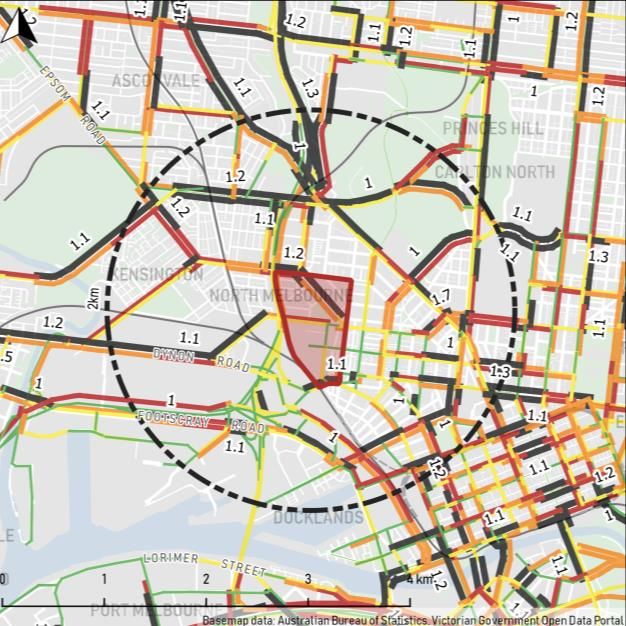
INTRODUCTION

PURPOSE

With an existing transport network that is constrained and congested, there are major challenges and questions as to how this level of
development is able to be supported and thrive.
Work is underway to take the Arden Vision and develop a                   Figure 1.2: Arden Key Connections                               Figure 1.3: Arden Key Connections
supporting structure plan, guiding the delivery of 34,000 jobs and
15,000 residents by 2051.
                                                                           LOCAL
With such significant numbers of new people working and living in           How do we make Arden a great place through
the area, the existing transport infrastructure will become more and
                                                                                           transport?
more strained over time. While strategic transport infrastructure is
currently being constructed, such as the MMRP and West Gate
Tunnel Project (WGTP), there is also a need to deliver a range of
more localised transport option.
                                                                           NEIGHBOURHOOD
Arden’s central location will make it a it a highly attractive place to
live and work into the future, as long as it is connected and
integrated at a precinct, inner city and metropolitan level.                        How do we connect into CBD?

Should the ‘Business as Usual’ approach to planning be adopted,
the area will continue to see a high car mode share, with increased
congestion and delay. This will lead to growth being inhibited,
resulting in lower returns on investment, and failure to deliver the        CITY-WIDE
Vision for Arden. As such, early planning and development of a
coordinated approach is required. This will help to understand the          How do we increase the accessibility of Arden
ultimate transport task of Arden and how the surrounding network                       to wider Melbourne?
will need to change in the context of a growing Melbourne.
GTA Consultants (GTA) has been engaged by the Department of
Economic Development Jobs Transport and Resources (DEDJTR)
to undertake a high level strategic transport capacity study. The
purpose of this study is to understand the ability, impact and
resulting transport network arrangements needed to support the
ultimate development in Arden.

                                                                                                                                                                          Source: Plan Melbourne 2017 – 2050
                                                                                                                                                                          Note: Arden station will be called North Melbourne
                                                                                                                                                                          and the existing North Melbourne station renamed
                                                                                                                                                                          West Melbourne

                                                                                Arden Urban Renewal Precinct | Transport Capacity Study                          UPDATED - 03/08/2021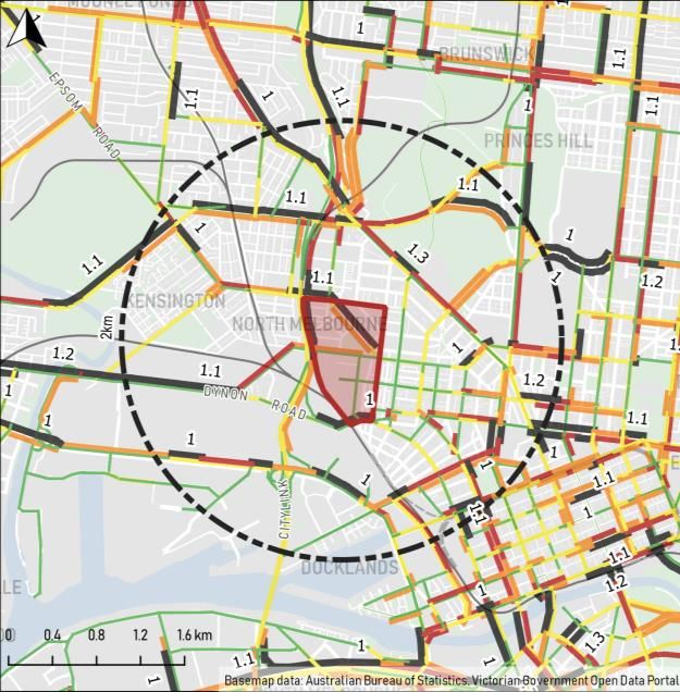
BACKGROUND

                                                                       02
             Arden Urban Renewal Precinct | Transport Capacity Study   UPDATED - 03/08/2021
BACKGROUND

ARDEN VISION

‘Arden will be a new destination for Melbourne, setting the standard for urban renewal. It will contribute to a future Melbourne that is not
only the world’s most liveable city, but also one of the most forward- looking.’ (pg. 8, Arden Vision)
Arden Vision - Victorian Planning Authority, 2018                      Figure 2.1: Key Transport Implications of Arden Vision                              Figure 2.2: Proposed Arden Transport Network
The Arden Vision confirms the state and local government
intentions for Arden. It acts as a first step in guiding local-level
planning in the urban renewal process. The document outlines                            High density mixed use precinct
several key planning directives:
▪      Designing a Distinctive Place
▪      Embedding Sustainable Change
▪      Accommodating Diverse Communities                                                                                    Source: Arden Vision (2018)

▪      Prioritising Active Transport
                                                                                               Mode share targets
▪      Investing in Community Infrastructure
▪      Creating Diverse Open Spaces
                                                                                                  Car
                                                                                                  10%

                                                                                     Active
                                                                                                                    Public
                                                                                     Travel
                                                                                                                    Transport
                                                                                      30%                             60%

                                                                                                                             Source: Arden Vision (2018)

                                                                                                                                                                                                       Source: Arden Vision (2018)

                                                                                   Arden Urban Renewal Precinct | Transport Capacity Study                                      UPDATED - 03/08/2021
BACKGROUND

STATE POLICY

State Government Policies identify that significant population growth is coming, and that our current land use patterns and travel behavior
can’t support this growth. Therefore, a more strategic approach to planning for how we live is being pursued by the State Government.

Table 2.1: State Policy Overview

State Policy                  Description                                                                                        Arden Implications

                              The Victorian Government released Plan Melbourne in 2016 (update of the previous
                                                                                                                                 The Plan identifies Arden as a Major Urban Renewal Precinct and future Activity Centre. The Plan
                              plan released in 2014). The Plan looks to build on Melbourne’s reputation as a global
Plan Melbourne                                                                                                                   states that Major Urban Renewal Precincts will play an important role in accommodating future
                              city of opportunity and choice, as it caters for an almost doubling of the population over
                                                                                                                                 housing and employment growth whilst making better use of existing infrastructure.
                              the next 35 years (i.e. out to 2051).

                              The TIA is the primary transport statute for Victoria, which enshrines a triple bottom line
                              approach to decision making about transport and land use matters. The Act requires
                              that all transport agencies work together to achieve an integrated and sustainable                 The TIA requires that Arden is developed in an integrated manner in terms of transport and land
Transport Integration Act
                              transport system, and that land use agencies take account of transport issues in land              use. The type of access should support the activities proposed to occur within and proximate to it
(TIA)
                              use decisions. Ultimately, this integration aims to help facilitate efficient, coordinated and     in a sustainable, safe and efficient manner.
                              reliable access to social and economic opportunities in a more sustainable, safe and
                              healthy way, both now and into the future.

                              The Movement and Place approach, based on the original Link and Place book                         Arden will be a destination in its own right. As such, the place function should be prioritised, with
                              produced in 2007 (Jones), recognises that transport links perform two functions:                   accessibility achieved through a connecting network and modes that don’t overly impact its
                              movement of people and goods, and serving as a place (a destination in its own right).             placemaking.
Movement & Place              The movement function is about minimising travel time and throughput, whilst the place
                              function is about encouraging people to stay and spend time in the location. The conflict          This is expected to be achieved by making Arden a pedestrian prioirity precinct, with the majority
                              of these functions aims to be better managed by setting their priorities and identifying           of access achieved through the most space efficient transport modes and interchange in a manner
                              the conditions needed to better support their desired operation.                                   that doesn’t impact the amenity / liveability of Arden overall.

                                                                                         Arden Urban Renewal Precinct | Transport Capacity Study                                        UPDATED - 03/08/2021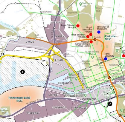
BACKGROUND

LOCAL POLICY

Local Planning Policies and Local Plans for the broader Strategic area will influence and be influenced by the future of Arden. A cohesive
planning approach is an opportunity to leverage opportunities.

Table 2.2: Local Policy Overview

Local Policy                  Description                                                                                       Arden Implications

                              The Melbourne Transport Strategy, focuses on planning for the expected growth of the              Key emerging themes include: bicycles should be seen as everyday transport; traffic (and
                              city and how transport can facilitate this through aggressive mode split targets by 2030,         congestion) should be reduced to create better streets; freight planning needs to make the last
Melbourne Transport
                              i.e. 30% walk, 10% bike, 20% car, 40% public transport. The City of Melbourne is                  mile more ‘sustainable’ (lower impact); car parking needs to be supplied in accordance with the
Strategy, City of Melbourne
                              currently refreshing its Transport Strategy, which is likely to include more ambitious            local vision; connecting the city by public transport is essential, including thinking about the
                              targets for improved outcomes for transport to 2050.                                              experience of people, including at interchanges and transfer points.

                              The Melbourne Bicycle Plan focus areas include increasing End of Trip Facilities,                 The plan highlights Arden as a major growth area. The plan specifically identifies opportunities to
City of Melbourne Bicycle
                              creating neighbourhood routes and improving connection into and through the city centre.          improve cycling connections to the existing cycling route on Arden Street. It is assumed that all
Plan, 2016 - 2020
                              As a part of the Transport Strategy refresh this is also being updated.                           new buildings at Arden will provide high quality end-of-trip facilities.

                              The City of Melbourne Walking Plan, which is currently also be refreshed, states that             The updated CoM Transport Strategy is tackling walking from a number of perspectives, including
City of Melbourne Walking
                              walking is the most important mode of transport for the City. The aim of the plan is to           rethinking city space, providing better experience, reallocation of road space, making it safer and
Plan, 2014 - 2017
                              increase the number of walking trips in 2030 by 63% from 2009 levels.                             how it support infrastructure investment.

                                                                                                                                The West Melbourne Structure Plan highlights specific transport interventions relevant to Arden.
                              The ‘Vision’ of the Structure Plan is for West Melbourne to retain its unique identity,
West Melbourne Structure                                                                                                        This includes tram and priority bus services that will be extended along Spencer Street to connect
                              varied areas of character and mix of uses it evolved into one of Melbourne’s distinct inner
Plan, 2018                                                                                                                      to Arden in the medium to long term. One of the key actions of the plan (Action 11) is to create
                              urban neighbourhoods and a counterpoint to the central city.
                                                                                                                                excellent walking and cycling connections to the new community hubs in Arden (and QVM).

                                                                                                                                One of the major transport initiatives for Fishermans Bend was setting an ambitious mode split
Fishermans Bend               The Framework is a long-term strategic plan which will guide the transition of Fishermans         target of 80% sustainable transport modes. With the mode share targets for Arden being even
Framework, 2018               Bend to home a target of 80,000 residents and host to 80,000 jobs.                                more aggressive (90% sustainable travel) the initiatives used for Fishermans Bend should be
                                                                                                                                considered at a minimum for Arden.

                                                                                        Arden Urban Renewal Precinct | Transport Capacity Study                                        UPDATED - 03/08/2021
BACKGROUND

MAJOR PROJECTS

There are several major infrastructure projects around the study area that will affect the accessibility of Arden, and North Melbourne more
broadly.

Table 2.3: Major Projects Overview

Project                         Description                                                                                Arden Implications

                                                                                                                           The new station at Arden will provide high capacity underground trains, running along new twin
                                                                                                                           tunnels between Kensington and South Yarra. The project will see the installation of five additional
                                                                                                                           stations, including the new North Melbourne station to be located within the Arden urban renewal
Melbourne Metro Rail Project                                                                                               area.
(MMRP)
                                                                                                                           The MMRP will also alleviate congestion in the exiting city loop by creating two loops. Ultimately,
                                                                                                                           more services will be able to be provided on all metropolitan lines which will improve Arden’s
                                                                                                                           accessibility by public transport.
                                                                                         Source: metrotunnel.vic.gov.au

                                                                                                                           The West Gate Tunnel will provide a second freeway river crossing and connection between the
                                                                                                                           Tullamarine Freeway and Geelong. It key aims are to divert freight traffic from local roads in the
                                                                                                                           inner west and improve access to the Port of Melbourne.

West Gate Tunnel Project                                                                                                   The associated transport modelling undertaken as part of the West Gate Tunnel Project and
                                                                                                                           presented in the Environmental Effects Statement, identifies an approximately 50% increase on
                                                                                                                           existing volumes on east-west roads such as Arden Street (ex. 6,000vpd), Victoria Street (ex.
                                                                                                                           6,000vpd) and Queensberry Street (ex. 3,000vpd). As these roads are already near to capacity,
                                                                                                                           much of this traffic is forecast to be outside of the peak period.
                                                                               Source: westgatetunnelproject.vic.gov.au

                                                                                                                           These major road-based infrastructure improvements will continue to support high levels of car
Broader freeway network         Monash Freeway, City Tulla Widening and the North East Link are major state                travel in many parts of Melbourne. By increasing the capacity along existing corridors and, given
upgrades                        infrastructure projects that are underway.                                                 Arden’s location near to a freeway, if access roads are upgraded and parking provided people will
                                                                                                                           respond by driving to Arden.

                                                                                   Arden Urban Renewal Precinct | Transport Capacity Study                                        UPDATED - 03/08/2021
BACKGROUND
LAND USE DENSITIES & MODE SHARES
The Arden Urban Renewal proposes a very high job density, which typically relates to lower private car use. However, further actions will
be required to deliver Arden Vision’s target car mode share of 10%
Figure 2.3: Job density vs car mode share for work trips The current general relationship that exists between employment
There is a tipping point where density and car mode shares in Melbourne is shown in Figure 2.3.
an increase in job density As the density increase, car mode shares tend to decrease ( This
reduces the private car mode occurs at least beyond a critical level of density of approximately
share. 1,000 jobs per square kilometre).
The urban renewal of Arden anticipates job densities of 68,000/km2.
According to the current relationship between density and mode
share, a private car mode splits of 30% or under could be expected
based on mode splits currently experienced in the CBD. This makes
the 10% private car mode share target (a 50% point reduction from
North today) a difficult target to achieve, based on current behaviour.
Melbourne
currently has a While there is a general downward trend in car use beyond the
high tipping point, there is variability in the resulting mode shares for a
employment given employment density. There are a number of factors that may
density and low cause this, which should be considered as part of developing
car mode share Arden:
▪ Population Density: relates to the majority trip generator or
Arden employment density 68,000 jobs per km2 destination population type
▪ Land Use Diversity: relative mix of generation and destination
based trips
▪ Pedestrian Orientated Environment: attractiveness of an area
for people to spend time
Target mode share for Arden
▪ Distance to Public Transport: walking distance to transit (i.e.
light/heavy rail/ etc.)
▪ Provision for End of Trip: Car parking (free or paid) and
cycling
▪ Access: travel time and capacity of each mode
Source: http://infrastructurevictoria.com.au/sites/default/files/images/Five-year%20focus%20-%20Immediate%20actions%20to%20tackle%20congestion%20-%20April%202018.pdf ▪ Price: cost per mode
[1] https://umanitoba.ca/faculties/management/ti/media/docs/cervero_-_5Ds_and_transit-Winnepeg-
Nov2011.pdf
Arden Urban Renewal Precinct | Transport Capacity Study UPDATED - 03/08/2021BACKGROUND
LIVING AND WORKING LOCALLY
A key part of increasing walking and cycling mode shares is to make decisions that support people to live locally
Living and working locally Transport and land use policy
The shorter the trip the more likely that it will be Figure 2.4: People that live and work in the same suburbs Creating a successful self-contained suburb
walked or cycled. Given that the mode share of Melbourne, 2011 - 2016 requires a number of policies to work together,
targets for Arden aim to achieve a high number including:
of trips by walking and cycling, ‘self contained’
trips within the precinct should form an - Land use planning needs to creates a mix
important aspect of both land use and transport of uses to satisfy residential and
planning. commercial demand
Self-containment is the idea that an area can - Land uses need to focus on local
provide for a persons’ daily needs, reducing the catchments and not those that draw people
need to travel long distances. It is achieved by car from across Greater Melbourne and
through the concentration of housing, services Regional areas (this is not something
and employment options for residents within currently considered by our planning
their local municipality. The degree of self- scheme)
containment of a region impacts transport
demand to and from the region, as employment - Economic investment /incentives need to
outcomes and service distribution influence create local employment opportunities that
travel distance and mode shares. cater for the populations that live in the
area – e.g. the inner city is more likely to be
Figure 2.4 shows a comparison of 2011 and professional services workers
2016 ABS Census data. Melbourne has seen
increased self-containment rates (as reflected - Transport planning should prioritise local
by the proportion of people living and working in transport links and potentially constrain
Source: ABS Census 2011 & 2016
the same suburbs) , with one of the largest connection to the strategic network.
increases of 4% seen in Inner Melbourne, the
sector inclusive of Arden, with a 73%
containment rate.
Arden Urban Renewal Precinct | Transport Capacity Study UPDATED - 03/08/2021BACKGROUND
CASE STUDY – FISHERMANS BEND FRAMEWORK
Fishermans Bend and Arden are comparable urban renewal sites with similar mode share aspirations.
Table 2.4: Arden and Fishermans Bend development Figure 2.5: Map of Arden and Fishermans Bend precincts Much like Arden, Fishermans Bend is envisaged as an extension of
characteristics the central city. Close similarities are present between the two
urban renewal areas, which are outlined in Table 2.5.
Fishermans
Characteristic Arden A major component of the Fishermans Bend urban renewal project
Bend
was to establish new benchmarks for sustainable transport in inner-
Melbourne. This would place the precinct among the most
sustainable transport cities in the world. A high sustainable transport
Distance to CBD 3km 2km
mode share target reflects an aim to shift away from the car-centric
‘business-as-usual’ approach (particularly for short-to-medium
length trips). Adopting a different approach is the only way to
Area 4.8km2 0.5km2 sustainably accommodate the population and employment levels
envisioned for the precinct.
Detailed investigations were undertaken as part of the review of
Proposed Residents 80,000 people 15,000 people
Fishermans Bend. These indicated that 2050 mode share targets of
20% to private vehicle and 80% towards sustainable transport are
realistic and broadly consistent with comparable suburbs. These
Source: GTA Consultants suburbs that are located within inner city Melbourne have a holistic
16,667 residents 30,000 residents public and active transport network, and are implementing
Population density
per km2 per km2 Fishermans Bend public realm measures to minimize the use of private cars.
As such, given the similarities between two developments, it is
Proposed Jobs 80,000 jobs 34,000 jobs reasonable to assume that the strategies that have been developed
for Fishermans Bend would be appropriate to implement in Arden.
These strategies are outlined on the next page.
16,667 jobs 68,000 jobs
Employment Density
per km2 per km2
Sustainable mode
80% 90%
share target
Source: Fishermans Bend Framework and Arden Vision Source: Studio Magnified
Arden Urban Renewal Precinct | Transport Capacity Study UPDATED - 03/08/2021BACKGROUND
FISHERMANS BEND TRANSPORT OBJECTIVES
Through the Fishermans Bend Framework a set of transport objectives have been developed to help achieve the 80% sustainable mode
share target.
Table 2.5: Fishermans Bend Transport Objectives Table 2.5 outlines the transport objectives set out as part of the
Fishermans Bend Framework (cover shown below)
Transport Mode Objectives The following mode share targets have been set in addition to the
transport objectives and the 80% sustainable mode share target:
▪ Objective 1.1: Deliver public transport services that connect to the existing Melbourne network and are a ten minute ▪ People with a wide range of abilities are able to get around
Public Transport walk from all residence and workplaces independently
▪ Objective 1.6: Support long-term sustainable transport patterns ▪ Accesses to services (community infrastructure, open space
and public transport) generally within 400 metre walk of homes
and businesses
▪ Objective 1.2: Make Fishermans Bend a great place to walk for people with a wide range of abilities and needs
▪ Objective 1.4: Create a street network that priorities walking and cycling while still facilitating vehicle access ▪ A walkability score of more than 90 via WalkScore is achieved
▪ Objective 1.5: Enable residents and workers to access public spaces and community facilities within an easy walk for all dwellings and workplaces
Walking ▪ Objective: 1.9: Create thriving, lively mixed-use neighborhoods that have a distinct identity and character, which
Fishermans Bend Framework
fosters social cohesion
▪ Objective 1.11: Align population, job growth and residential densities with the provision of infrastructure and
amenities
Cycling ▪ Objective 1.3: Make Fishermans Bend an exceptional place to cycle
▪ Objective 7.1: Develop Fishermans Ben as a zero net emissions precinct
Private Vehicles
▪ Objective 1.4: Create a street network that prioritises walking and cycling while still facilitating vehicle access
Servicing ▪ Objective 1:7 Support low-impact methods of delivering last-km-freight and waste removal
Vehicles ▪ Objective 8.2: Reduce amenity impacts from waste collection
Source: Fishermans Bend Framework Source: Fishermans Bend Framework
Arden Urban Renewal Precinct | Transport Capacity Study UPDATED - 03/08/2021EVIDENCE & TESTING
03
Arden Urban Renewal Precinct | Transport Capacity Study UPDATED - 03/08/2021EVIDENCE & TESTING
ARDEN LAYOUT CONTEXT
A preliminary built form and land use concept plan has been prepared for Arden to test the aspirations outlined in the Vision and enable
further work to be undertaken to develop a structure plan.
The proposed layout of Arden is shown in Figure 3.1. It generally The internal road network to the south of Arden Road will generally Figure 3.1: Preliminary built form and land use concept plan
consists of two parts that are separated by Arden Street: limit vehicle access, with only service vehicles expected to need to
access each building. Car parking is planned to be accommodated
▪ Arden North: A high density residential land uses provided to through structured facilities that are accessible via the internal road
the north around the existing sports fields and park lands. A along the western frontage of Arden.
potential school is proposed on the north site of Arden Street.
There is limited detail around the pedestrian and bicycle facilities.
▪ Arden Central: A high density mixed use precinct to the south The provision of active travel infrastructure is expected to be of a
that is centered around a station. Arden has a potential hospital very high-quality, wide and give priority to users at road
on the south side of Arden Street and separated car parking intersections.
stations along the western side.
Given the target mode shares establish people walking and cycling
Access to the new North Melbourne train station is at the heart of as the majority mode, even at this early concept stage, we would
Arden, with only one street access proposed at this stage to expect the transport networks to clearly link to the wider sustainable
Laurens Street. A second portal access to the central open public transport network.
space of Arden is also being considered. This access will cater to
the increasing demands from Arden as it continues to develop. The
new North Melbourne Station is also located within walking distance
of North Melbourne Station and Macaulay Station. Both of these
train stations are located on different Metro lines, and are likely to
generate movements and activity between them.
An extension of the Spencer Street tram along Laurens Street is
also proposed. This tram line will stop at the new North Melbourne
Station, which will provide public transport access for more local
trips (longer trips will be better serviced via the proposed rail
services). Like the CBD Arden needs to be connected by a number
of different public transport options servicing different needs.
Arden Urban Renewal Precinct | Transport Capacity Study UPDATED - 03/08/2021EVIDENCE & TESTING
TRAFFIC CONDITIONS – YEARS 2016 AND 2051
Utilising the 2016 and 2051 State Government's Transport Modeling (S-VITM) it can be seen that the road network connecting Arden is
currently congested and expected to get worse.
Figure 3.2: 2016 AM Peak 2hr Volume / Capacity Plot Figure 3.3: 2051 AM Peak 2hr Volume / Capacity Plot
Based on the 2016 S-VITM (State-wide Victorian Integrated
Transport Model) reference case shown in Figure 3.2, the road
network proximate to and connecting Arden generally has sections
along each arterial road that are highly congested, i.e. V/C > 0.9.
There are a number of roads on the north and east sides of the
precinct that are proximate, such as Boundary Road, Abbotsford
Street, Curzon Street , Arden Street and Queensbury Street. These
roads seem to be operating reasonably well, and therefore present
an opportunity for road space to be reallocated to other modes.
At a broader level, Arden is difficult to access by car. Major arterial
roads in the surrounding area such as Macaulay Road, Spencer
Street, Flemington Road, Dynon Road and Racecourse Road are
very congested. This clearly poses an issue in attempting to cater
for demands into the future.
Based on the 2051 S-VITM reference case shown in Figure 3.3, the
road network proximate to and connecting Arden will become even
more congested. Many additional sections of the arterial roads in
the area have reached capacity when compared to the previous
years model.
This increased level of congestion is shown to be spreading along
the busy main roads. Many of the proximate roads in the north and
east, however, maintain similar congestion levels into the future.
The above traffic information is very preliminary in nature and should not be relied on
to understand the current operation of specific roads and/or sections of them. Rather, it
has been provided to give context around general levels of use and operation at a
network level.
Arden Urban Renewal Precinct | Transport Capacity Study UPDATED - 03/08/2021EVIDENCE & TESTING
STRATEGIC ACCESSIBILITY MAPPING OVERVIEW
Mode split targets have been set for Arden. The ability for targets to be achieved has been investigated through the 2051 S-VITM model
year and mapping the accessibility of each modal catchment.
Understanding how the people who are proposed to live and work The associated modal accessibility mapping process is shown in Figure 3.4: GTA Strategic Accessibility Mapping Approach
access Arden was undertaken by analysing S-VITM demographic Figure 3.4. A description is provided below and the results
data outputs. The 2051 S-VITM model year was used with the presented hereafter:
associated Arden zone’s accessing population increased to reflect
the envisioned resident and jobs numbers. ▪ Modal Catchments: Identify the likely typical travel times and /
or distances that people would use for each mode in accessing
Modal Catchments
The resulting S-VITM demographic outputs showed where the trips Arden. This will utilise S-VITM’s estimation of where the
of people living in Arden go to, and those accessing it for accessing population is within each of the below modal
employment originated from. catchments.
With this understanding and what modes could reasonably be used ▪ Walking: Within 2km of Arden. This broadly relates to a 20min
to support these trips to and from Arden, an understanding of what
mode splits could potentially be achieved for Arden.
walking distance (except those within the 20 minute public
transport catchment). Public Transport
It is noted that if you let S-VITM determine what the mode splits will ▪ Cycling: Within 5km of Arden. This broadly relates to a 20min
likely be accessing Arden it will be based on associated modal cycling distance (except those within the 40 minute public
travel times. However, human behaviour is a bit more complex than transport catchment).
this and can be significantly impacted through various hard and soft
▪ Public Transport: Residents and places of employment within
transport demand measures,
60 minutes travel time of Arden. This is based on the public Walking
As such, the focus of this accessibility mapping is to understand transport network and services assumed to be in place as part
what mode splits are possible and what level of hard and soft of the 2051 S-VITM reference case.
transport demand measures are needed to achieve the desired (20 minute travel time has been utilized within the walking and
mode split targets for Arden. 40 minute catchment travel time has been utilized within the
cycling catchment).
▪ Private Car: Residents and places of employment within a 60
minute travel time catchment of Arden (beyond the walking and
Cycling
cycling catchments. This is Based on the road network
assumed to be in place as part of the 2051 S-VITM reference
case.
Those that reside or employment that is located beyond 60 minutes
travel have been excluded from this analysis. This decision was
made as the ability to identify which modes they will use is
Private Car
considered to be uncertain.
Arden Urban Renewal Precinct | Transport Capacity Study UPDATED - 03/08/2021EVIDENCE & TESTING
MODAL CATCHMENTS
Transport demands are essentially built off the need for people to travel between where they are and where they need to be, such as
getting from home to work or school.
S-VITM is built on the Victoria in Future (VIF) demographic Figure 3.5: Resident Locations Relative to Subject Site
projections. This data is provided for each five years between 2016
and 2051 for metropolitan Melbourne (link below).
https://www.planning.vic.gov.au/land-use-and-population-
research/victoria-in-future-2016
The VIF projections are distributed across metropolitan Melbourne
based on best estimates around where people will live, work, shop,
go to school, etc. (residential distributions in metropolitan Melbourne
relative to Arden are shown in Figure 3.5).
S-VITM is not considered to be exact or comprehensive. In 2051
the associated zone in the model for Arden had only a small portion
of the proposed level of residents and jobs. This model however is
considered to provide a best estimate understanding of what is
expected, and is helpful in understanding the general level of
change.
The demographic projection data is then taken by S-VITM and used
to identify a volume of information, such as: where people will be
located, want to travel, what mode / route they will take and the
resulting demands on the network. This is done using a gravity
based approach between trip generators and destinations.
The accessibility and mapping presented in this report have been
based on the outputs of S-VITM. These assume the associated
population distribution of those that are expected to access Arden in
2051 when fully built out (i.e. accommodates 34,000 job and 15,000
residents) .
Arden Urban Renewal Precinct | Transport Capacity Study UPDATED - 03/08/2021EVIDENCE & TESTING
WALKING
Arden and surrounding area is expected to be highly walkable. This will be achieved through the provision of a comprehensive and fine-
grain network, low speed environment, priority crossing facilities, high-quality landscaping and supportive facilities. However, works
outside Arden and behavior change initiatives will also be required to cater for movements to Arden.
Analysis of S-VITM shows that in 2051 there are 134,000 residents within a Figure 3.6: Proportion of people likely to walk to Arden
2km walking catchment to Arden. As shown in Figure 3.6. Of these 60%
come from the adjoining neighborhoods.
The 2km walking catchment to Arden (i.e. those accessing employment at
Arden) is show in by the pink shading in Figure 3.6. It also shows that there
is good access to North Melbourne, Kensington, Kensington Banks, and 9%
parts of Flemington.
The areas show in yellow are those that do not have good public transport
but, given the proximity, people within these areas have a higher likelihood
for walking to Arden if the right environment is provided. 60%
There is expected to be a significant proportion of internal trips, given the 5%
6%
mixed use nature of Arden. Guidance on internal trip generation rates can
be sourced from VISTA (the household survey for travel patterns) for
residential land uses. The breakdown of trips by purpose across
metropolitan Melbourne is shown below:
▪ Employment trips: 25.5%
▪ Education trips: 9.5%
▪ Retail/Shopping trips: 17.4% 11%
▪ Social trips: 12.4%
▪ Recreation trips: 5.3%
▪ Other Trips: 30.1%
For strategic planning purposes we have adopted a 25% internal resident 9%
trip rate. This could be adjusted based on further planning and high levels
of self-containment (e.g. the mix of land uses is conducive to local-living)
Arden Urban Renewal Precinct | Transport Capacity Study UPDATED - 03/08/2021EVIDENCE & TESTING
CYCLING
The cycling catchment to Arden is expected to be fully developed by 2051, with high quality and separated routes along strategic routes,
with connected feeder routes to neighborhoods with low speed and traffic volumes.
There are 629,000 residents between 2km and 5km of Arden. Figure 3.7: Cycling Catchment & User Numbers Travelling to Arden
Analysis of S-VITM shows a high proportion of people travelling to
and from Arden by bike (1,200 travel to Arden in the AM peak period
by bike; 400 travel from Arden in the AM peak period by bike).
Shaded in pink Figure 3.7 shows the 5km cycling catchment to
Arden (i.e. those accessing employment at Arden).\
The remaining areas that are highlighted in green are those that
don’t have good public transport but given the proximity to Arden
these areas have a higher likelihood for cycling to Arden if the right 15%
environment is provided. This analysis suggests that there is
significant opportunity to provide well-used cycling corridors if you
connect the Inner North, Inner West and Fishermans Bend.
6%
These areas will need to be connected through high quality facilities
to allow people that reside in the adjoining neighborhoods to cycle.
Currently, there are significant barriers – mostly relating to unsafe
infrastructure - to accessing the surrounding areas by bike.
Analysis undertaken by the City of Melbourne suggests that 11 per
cent of people used a bicycle during some part of their travel day
whereas 25 per cent used a bicycle over the previous week. This
creates a significant ‘near-market’ of people who will cycle more if
provision is made.
Achieving high mode shares for cycling is about making it an option 67%
(for some but not all trips) for a wide range of users through
strategic routes with connectors into low traffic neighborhood
streets. To make the most of Arden’s central location safe
continuous infrastructure that connects it to surrounding areas
needs to be a priority. 9%
Arden Urban Renewal Precinct | Transport Capacity Study UPDATED - 03/08/2021EVIDENCE & TESTING
PUBLIC TRANSPORT
In 2051 Arden is expected to be highly accessible by public transport. Arden will contain North Melbourne Station, two other stations within
walking distance, a potential tram route extending through it and a bus network filling in the gaps.
To understand how many people can access Arden via public Figure 3.8: Public Transport Catchment & Users Numbers Accessing Arden
transport we have analysed the 2051 S-VITM transport model.
The 60-minute public transport network catchment for Arden is
shown in Figure 3.8.
Our analysis shows that 3,034,000 residents (including those that
could also walk and cycle as they live locally) can access Arden in
less than 60 minutes in 2051.
This suggests that Arden will be highly accessible by metro train
and, via interchange at Sunshine, regional areas to the North and
West of Victoria.
Strategic analysis of VITM suggests further work is needed to
understand the relationship between Arden and Melbourne,
analysis of S-VITM suggests that nearly 11,000 people travel to
Arden in the AM peak by public transport
(includes 700 from within the walking catchment and 2,400 from
within the cycling catchment).
Arden Urban Renewal Precinct | Transport Capacity Study UPDATED - 03/08/2021EVIDENCE & TESTING
PRIVATE VEHICLE ACCESS
A large part of metropolitan Melbourne will still access Arden by private vehicle. This is due to close access to the existing Freeway
network and major road projects that are set to come online.
A large part of metropolitan Melbourne is within a 60-minute drive, Figure 3.9: Private Vehicle Catchment & Users Numbers Accessing Arden
including the northern growth corridor. Arden is highly accessible by
car in 2051 due to its connections to an extensive freeway network,
and the continued investment into the freeway network, such as
North East Link and the West Gate Tunnel.
To understand how many people who could drive to Arden (or to a
station and then catch public transport to Arden) we extracted the
number of people who are outside of public transport-only
catchment.
According to the S-VITM model in 2051 there are 2,394,000
residents within driving catchment or Arden (but not within the
walking, cycling and public transport catchments).
S-VITM also shows that 4,000 drive to Arden in the AM peak period
by car, and 500 drive from Arden in the AM peak period by car.
These model results show low use of car for travel to Arden, but
also intimates that, if the mode share targets in the Arden Vision are
to be achieved, access to Arden by private car will require need to
be reduced through management of demand.
International evidence, evidences that the provision of car parking is
critical to managing demand for demand for car travel. The current
level of car parking provision provided in the preliminary built form
and land use concept plan equates to 0.11 spaces per resident and
employee. If all these spaces were used daily, this would broadly
equate to an 11% mode share. Given the targets, this should
therefore be reduced to 10% to achieve the targeted mode share.
Arden Urban Renewal Precinct | Transport Capacity Study UPDATED - 03/08/2021EVIDENCE & TESTING
STRATEGIC ACCESSIBILITY MAPPING SUMMARY
The strategic accessibility mapping indicates that more than 10% of people will likely access Arden by car1, so transport demand and site
arrangement measures will be required to suitably discourage private car use.
The expected mode splits for residents and employees in Arden are
shown in Table 3.1. The table indicates there will be 18% car, 58% Table 3.1: 2051 Arden AM Peak 2-hour Ingress / Egress Mode Shares (based on GTA Strategic Accessibility Mapping)
public transport and 24% active travel in the AM peak period (if
Mode Employment (ingress) Residents (egress) Total
internal trips are not included then the car mode split would be
21%). Public Transport 10,700 60% 3,400 53% 14,100 58%
The 18% car mode share in the AM peak 2 hours is expected to Walking 470 3% 486 8% 956 4%
result in 4,500 people access Arden. If we assume typical car
occupancy levels of 1.1 person per car, then some 4,090 vehicles Cycling 1,200 7% 400 6% 1,600 7%
will access the site in the AM peak 2-hours. If the car mode split can
be reduced to 10% then the volume of vehicles will be reduced to Private Vehicle 4,000 22% 500 8% 4,500 18%
2,000 accessing the site. This would be well within daily fluctuation
levels of most major arterial roads in the area. Internal (walking) 1,595 9% 1,595 25% 3,191 13%
A comparison of the ‘Resulting’ and ‘Target’ mode splits is shown in Total 17,965 6,4381 24,347
Figure 3.10. This indicates that the active travel split is slightly lower
than targeted. Car use is, however, nearly double what is being Figure 3.10: 2051 Mode-Share Comparisons (GTA Strategic Accessibility Mapping vs Target)
targeted.
This analysis is indicative but helps understand how accessible the
site could be and where people are likely to come from to work in
Arden. The results illustrate that Arden is highly accessible by public 10%
18%
transport and that there is significant potential for active transport to
be the choice for many.
Any analysis of potential catchments assumes a high-quality safe 30%
experience. To deliver 10% car travel to the area, and the
associated benefits, many transport-related planning/engineering 24% 58% 60%
choices need to be made (e.g. priority at junctions, car parking, lane
widths and width of cross sections).
GTA Strategic Accessibility Mapping Results Arden Vision Mode Shares
1. Based on ‘business as usual’ conditions and assuming no major policy or infrastructure interventions. Source: Arden Vision and GTA Consultants
Arden Urban Renewal Precinct | Transport Capacity Study UPDATED - 03/08/2021EVIDENCE AND TESTING
MODE SHARES – TOP DOWN ANALYSIS
Use of Mode Split targets to align planning activities is becoming common place in Australia.
Mode share is widely used in strategic transport planning as a
Table 3.2: Current Mode Share for Inner City Suburbs (ABS Census 2016)
strategic performance metric outside of Australia. For example,
Transport for London’s most recent Mayor’s Transport Strategy Distance From GPO
(the London wide transport strategy) includes a mode share Suburb Sustainable Transport Car Other
(approx.)
expected value of 80 per cent of trips being made by walking,
cycling and public transport by 2041. This target applies to the Docklands 1.5km 75% 24% 1%
whole of London and reflects the long-term trend of a shift Carlton (Vic.) 1.6km 78% 21% 1%
towards walking, cycling and public transport.
Southbank 1.6km 77% 22% 1%
Though Plan Melbourne does not include mode share targets,
many local authorities, including the City of Melbourne, use mode Fitzroy (Vic.) 1.9km 71% 27% 1%
share targets to guide decision-making. West Melbourne 2.1km 75% 24% 1%
To inform our planning, 2016 Census data provided by the North Melbourne 2.2km 71% 27% 2%
Australian Bureau of Statistics (ABS) has been analysed to Parkville (Vic.) 3.1km 68% 31% 1%
establish mode shares for inner-city suburbs, as shown in Table
3.2.
Source: Fishermans Bend Planning Panel review
Arden’s mode share for cars is expected to be 10% based on the Table 5.2:Current Mode Share for Inner City Suburbs (ABS Census 2016)
Noting: ‘sustainable transport’ is defined as walking, cycling and public transport trips. For the purposes of this assessment of Census data, we have extended upon this definition to also include ‘Car as
accessibility mapping analysis. If achieved, this would make it passenger’. This category will likely comprise predominantly carpooling passengers in a shared vehicle. Carpooling could be c ategorised as sustainable in that the trip does not contribute any additional
slightly lower than the existing level of car use in the inner impact on the transport network or in terms of environmental sustainability (i.e. emissions using a shared vehicle). ‘Worked from home’ responses are also considered, in this analysis of Census data, as
suburbs of Melbourne. sustainable transport, as this speaks to reducing the need for travel. All other categories (‘taxi’, ‘truck’, ‘motorbike’ and ‘other’) are classified as ‘other’. ‘Did not go to work’ responses have been excluded
from the analysis.
Achieving a mode share target of 10% car trips is not
unachievable, but our analysis suggests that it is
challenging. It is an unparalleled opportunity but also a
significant challenge and requires a change in how we plan
transport.
There needs to be early prioritisation of public and active
transport, integration of site layout design elements will be
required and the implementation of demand management
measures.
Arden Urban Renewal Precinct | Transport Capacity Study UPDATED - 03/08/2021EVIDENCE & TESTING
SWOT ANALYSIS
The proposed transport arrangements are expected to generally help achieve the Arden Vision, but this is subject to several issues being
resolved and opportunities capitalized on.
Mode Share Targets Geographical Limitations Summary:
The Arden Vision outlines an ambitious goal of 90% of all trips The site is land locked by the creek to the west and the rail The ambitious goal of 90% of all trips to Arden made by sustainable
to Arden made by sustainable modes by 2051: corridor to the south: modes by 2051 sets a clear target to work towards.
▪ Strength it provides a policy framework for the implementation ▪ Strength it links well to existing communities of the inner West
of measures to prioritise investment and allocate road space and North There is more work to be undertaken to detail how this will be
achieved – either in terms of demand (how people will travel) and
▪ Weakness the target has not been subject to detailed ▪ Weakness it limits the opportunities to access the site via the supply (funding for transport).
backcasting to test what is needed to achieve it existing street network and creates congestion
▪ Opportunity creating a place that caters to people rather than ▪ Opportunity limited access may help reduce high through Arden sits between established communities and has good
vehicles will improve the vitality and economic success of Arden traffic and ensure Arden is treated as a ‘destination’ rather than transport links but a business as usual approach to transport
a corridor. planning will mean that people use major roads to access the site.
▪ Threat there is no detailed information on how the target will be
achieved. Arden also has easy access to the Freeway network. ▪ Threat it is competing with other inner city urban renewal areas
and National Employment Clusters for investment, particularly The next section of the report makes some preliminary
as it relates to major transport infrastructure (above and beyond recommendations on how to address the points raised in this
MMR). SWOT and provides some direction on next steps for transport
planning of Arden.
Public Transport Internal Network
There is a commitment to build the North Melbourne Station The preliminary built form and land use layout concept plan
within Arden as part of the Melbourne Metro Rail Project: shows a high-density, pedestrian friendly area with limited
vehicle access:
▪ Strength it will make Arden highly accessible by public
transport ▪ Strength Arden layout will promote active travel as a viable
mode of transport, especially for internal trips
▪ Weakness there’s no commitment to other public transport and
a perception that the train alone will meet the public transport ▪ Weakness the usage of the network may be limited by poor
needs of Arden integration with neighboring suburbs
▪ Opportunity it can greatly reduce local congestion and provide ▪ Opportunity low speeds mean that shared spaces may be
access for a large number of Melbourne appropriate, especially if access is restricted by time of day
▪ Threat if the station is not well integrated with the rest of Arden ▪ Threat the extension of Langford Street along the western edge
it may be underutilised. of Arden may encourage ‘rat running’ of vehicles trying to avoid
congestion on the major roads outside of the site.
Arden Urban Renewal Precinct | Transport Capacity Study UPDATED - 03/08/2021RECOMMENDATIONS
04
Arden Urban Renewal Precinct | Transport Capacity Study UPDATED - 03/08/2021RECOMMENDATIONS
URBAN FORM FACTORS
Below are the urban form factors that have been identified through research to influence travel behaviours. These should be considered
when developing the Arden layout and how it is accessed.
Figure 4.1: Urban Form Factors Arden is proposed to be a densely populated precinct for both
residents and workers. This offers an opportunity to leverage off the
number of short / internal trips created by this self-containment. It
also means there is a strong case for further investment in more
sustainable and space efficient transport infrastructure given the
associated high access demands.
The new North Melbourne Station and existing adjacent stations
Density
will connect Arden to the Melbourne CBD, Parkville NEIC and the
broader metropolitan area. The layout of Arden needs to be The mixing of residential, employment and retail land uses help
designed to make access to these train stations easy and attractive create more internal / short trips via active and public transport. It
by foot and bike.
should be noted that the high employment numbers proposed in
Distance to
Land use Arden will likely service the local residential catchment as well as
transport Reduced car use diversity the internal resident population.
nodes in favour of
public transport
and active travel
Pedestrian and
At the moment, the surrounding road space of the network is Destination cycling
generally private vehicle focussed, which has resulted in high traffic accessibility orientated
volumes and congestion. In order to make Arden more accessible design
by active and public transport the surrounding road space should be Providing a fine grain pedestrian and cycling orientated network in
reallocated towards these modes. This potential has been shown to and around Arden will help reduce the reliance on private car use in
be possible through the accessibility mapping analysis, if the accessing Arden and once there (i.e. attractive to access and spend
infrastructure to connect Arden exists. time within Arden for multiple purposes).
Source: GTA Consultants
Arden Urban Renewal Precinct | Transport Capacity Study UPDATED - 03/08/2021RECOMMENDATIONS
WORK REQUIRED TO ACHIEVE MODE SHARE OBJECTIVES
Further scenario development and analysis is recommended to validate the network and precinct initiatives required to achieve the target
mode share for Arden.
Table 4.1: Next Steps
Topic Recommendations
Scenario Analysis ▪ Develop a number of precinct and wider area scenarios for the transport network with the given land use projections. This process is similar to the development of the strategic and
detailed planning for Fishermans Bend
▪ Understand the need and demand for other public transport services
▪ Identify preferred public transport arrangements to service Arden and how they might integrate with other services and needs in the area
Modelling ▪ Undertake strategic transport and pedestrian modelling of Arden based on the Scenarios developed above. This would be based on an interim year (e.g. 2031) and the ultimate
development year (e.g. 2051)
▪ Undertake population modelling to identify the number of people that will be accommodated within Arden and their trip purposes / types. Then based on the mode split targets, identify
the associated facilities needed to support them (i.e. car and bicycle parking facilities, restrictions and types, lockers, showers, etc.)
Increasing walking ▪ Ensure high quality local walking and cycling links within and to Arden
and cycling through ▪ Plan for land-uses that reduce trips from far afield e.g. limit special uses that draw people from across Melbourne (e.g. a zoo)
living locally ▪ Employ travel demand management strategies to disincentivise long trips
▪ Reduce the number of access points to the area by private vehicle (whilst allowing for filtered permeability for pedestrians and bikes)
Engagement with ▪ Work with the MMR team to ensure the North Melbourne Station is fully integrated with Arden
Transport Agencies ▪ Work with Bus and Tram planning teams in Government (TfV) to develop the on-road public transport network, including phasing
▪ Reflecting the mode share targets, agree cross sections by street type and junction designs
▪ Agree interfaces with key strategic active transport links, primarily access across major roads to surrounding neighborhoods and the Capital City Trail (as identified above)
Provision of car ▪ Promote a fundamental shift away from private car ownership and privately accessed car parking spaces (home or for work)
parking ▪ Aligned with the CBD, Fishermans Bend, London, Mexico City and San Francisco, a maximum car rate appears to be an appropriate tool to achieve sustainability goals at Arden
▪ At the Fishermans Bend Planning Panel a maximum rate of 0.5 space per dwelling was considered appropriate to achieve a 20% car mode share, given this, a similar rate should be
adopted at Arden
▪ Deliver car parking structures that can transition to other uses over time
Arden Urban Renewal Precinct | Transport Capacity Study UPDATED - 03/08/2021RECOMMENDATIONS
ARDEN ACCESSIBILITY & LAYOUT
Based on the SWOT analysis, the recommendations below should be part of the Scenario Analysis to help make Arden highly accessible
by active and public transport in order to achieve the target mode splits.
Table 4.2: Accessibility & Layout Recommendations
Topic Recommendations
Mode Share Targets ▪ Based on the identified catchments for each mode, review the suitability of the existing arrangements to connect them to Arden
▪ Identify phased infrastructure to deliver the overall mode share targets
▪ Create a land use planning framework that reduces the number of car trips needed for business purposes to the area
Geographical ▪ Identify the key accessibility barriers to walking and cycling catchments
Limitations ▪ Develop options to overcome the geographical accessibility barriers, such as new infrastructure, upgrades, alternative routes and/or modes, wayfinding, etc.
▪ Assess the options to identify a preferred approach and develop an implementation plan
Public Transport ▪ Orientate the development to North Melbourne Station and Macauley Station to the north
▪ Understand the need and demand for other public transport services
▪ Identify preferred public transport arrangements to service Arden and how they might integrate with other services and needs in the area
▪ Given the density of Arden, ensure that the public transport interchange at the station (particularly train-bus) is a lower priority than pedestrians
Internal Network ▪ Prioritise pedestrian movement
▪ Minimise the potential for vehicles to access Arden, especially those that can be used as through routes
▪ Locate car parking facilities to allow for shared use and future repurposing
▪ Considered centralising loading, services and waste through a consolidation centre
Arden Urban Renewal Precinct | Transport Capacity Study UPDATED - 03/08/2021You can also read