Assessing ecosystem services of abandoned agricultural lands: a case study in the forested zone of European Russia - One ...
←
→
Page content transcription
If your browser does not render page correctly, please read the page content below
One Ecosystem 7: e77969
           doi: 10.3897/oneeco.7.e77969

                                                     Research Article

Assessing ecosystem services of abandoned
agricultural lands: a case study in the forested
zone of European Russia
Daria Anpilogova‡, Alla Pakina‡
    ‡ Lomonosov Moscow State University, Faculty of Geography, Department of Environmental Management, Moscow, Russia

   Corresponding author: Daria Anpilogova (d.anpilogova@mail.ru)

   Academic editor: Paula Rendon

   Received: 13 Nov 2021 | Accepted: 18 Jan 2022 | Published: 01 Feb 2022

   Citation: Anpilogova D, Pakina A (2022) Assessing ecosystem services of abandoned agricultural lands: a case
   study in the forested zone of European Russia. One Ecosystem 7: e77969.
   https://doi.org/10.3897/oneeco.7.e77969

Abstract
The massive abandonment of arable land in Russia in the 1990s had a heavy impact on
the country’s land-use structure. The cessation of cultivation leads to a decrease of
provisioning ecosystem services within the landscape, while creating an opportunity to
enhance the supply of diverse regulation services. Consideration of this opportunity is
increasingly important for environmental management and landscape planning. In this
article, we present an approach for assessing the environmental benefits of ecosystems
developing on abandoned arable lands in the forested zone of European Russia. The
proposed methodology is established on a land-cover based framework – ecosystem
services assessment matrix. For assessment purposes, abandoned arable lands at
different stages of vegetation recovery succession (ruderal, grassland and small-leaved
forest) are considered as different land-cover types. Four classes of regulating ecosystem
services are subject to qualitative analysis: regulation of the chemical composition of the
atmosphere, control of erosion rates, regulation of soil quality and pollination. An
exemplary application of the proposed methodology for the case study area located in the
Moscow Region of Russia is presented in the article. The results of the qualitative
assessment revealed an association between the stage of vegetation recovery succession
which corresponds with the time since land abandonment and the supply of regulating

© Anpilogova D, Pakina A. This is an open access article distributed under the terms of the Creative Commons Attribution License
(CC BY 4.0), which permits unrestricted use, distribution, and reproduction in any medium, provided the original author and source
are credited.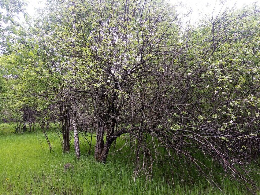
2                                  Anpilogova D, Pakina A

ecosystem services. The recovery of natural vegetation leads to higher levels of carbon
sequestration, more effective erosion mitigation, soil recovery and increased pollinator
abundance. Cropland was proven to be a recipient of the services provided by natural
ecosystems. Thus, the return of all uncultivated fields to agricultural use will cause a
substantial decrease in the ecological value of the study area.

Keywords
agricultural landscape, assessment matrix, land abandonment, land-use change, land-
cover, regulating services, secondary succession

Introduction
Agricultural land abandonment is a common land-use trend of the last few decades across
the developed and transition economies, such as EU countries and post-Soviet countries
(Romanenko 2008, Lasanta et al. 2019). This land-use process is driven mainly by the
intensification of agriculture or by various socio-economic factors, including market
incentives, rural depopulation and industrialisation (Rey Benayas 2007). In Russia,
massive withdrawal of cropland and pasture from agricultural use took place in the 1990s
following the decline of the Soviet system. This phenomenon was determined by large-
scale socio-economic and institutional changes, followed by a deep crisis in the agricultural
sector. Although the extent of abandoned agricultural land varied widely between regions,
depending on local soil and climatic conditions and the degree of land degradation, as well
as socio-economic conditions, the overall decrease in cultivation amounted to
approximately 48 million hectares in the period 1990—2007 (Lyuri et al. 2010, Nefedova
and Medvedev 2020). National and regional agricultural development programmes
launched after 2010 facilitated the return of abandoned fields to agricultural use. However,
according to the latest Russian Agricultural Census (2016), the proportion of abandoned
agricultural land remains high: it may be as great as 44% of the original cultivated land.

After cultivation, the development of restoration processes is usually focused on the
formation of zonal climax ecosystems through a sequence of stages of post-agrogenic
plant succession. In the forested zone of European Russia, old-field plant successions
predominantly follow the same pattern and consist of four successive stages, presented in
Fig. 1 (Lyuri et al. 2010, Prévosto et al. 2011). The length of each stage and the exact
structure of the plant community vary according to the biome (middle and southern taiga,
broadleaved forest). At the first ruderal stage, the bare soil, freshly exposed by ploughing,
is quickly colonised by pioneers, annual and perennial herbs and grasses. In approximately
three years, the ruderal community gives place to grassland, where the vegetation cover is
dominated by light-demanding meadow grass associations. At this successive stage,
arboreal species are insinuating into the grass canopy. At the third stage, the young small-
leaved or pine forest is establishing. Finally, post-agrogenic succession arrives at a
relatively stable climax or subclimax forest community. It can be either a broadleaved or
dark coniferous forest, depending on the soil and climatic conditions.
Assessing ecosystem services of abandoned agricultural lands: a case study ...   3

 Figure 1.
 Plant succession after field abandonment in the forested zone of European Russia. Based on
 Lyuri et al. (2010). Photos: D. Anpilogova.

Cultivation cessation and subsequent recovery of natural vegetation initiate the process of
post-agrogenic soil restoration. Although the period of full restoration is long-term, from 50
to 300 or more years, depending on the soil type, there is a clear trend of soil development
towards the morphological and chemical properties, typical of undisturbed regional soils
(Kalinina et al. 2015, Ward et al. 2021). The former uniform plough horizon gradually
becomes less compact and stratifies, while the plough boundary remains present in the soil
profile during the periods studied in the literature. During the recovery period,
pedodiversity, decomposer activity and soil organic matter increase over time (Kurganova
et al. 2008, Kalinina et al. 2019).

Presently, the abandonment of agricultural land is drawing increasing attention of both
policy-makers and the scientific community. From a socio-economic perspective, this
phenomenon is often regarded as harmful because of the drop in agricultural output and
loss of employment in rural areas. From an ecological point of view, both positive and
negative consequences of abandonment can be identified in different regions. The
negative effects include reduction of landscape diversity, higher fire frequency and specific
biodiversity loss caused by landscape homogeneity (Rey Benayas 2007, Cursach et al.
2020). Several studies have considered potential benefits for the environment related to
post-agrogenic recovery of vegetation and soil (Buehnemann 1980, Rey Benayas 2007,
Navarro and Pereira 2012). These include ecosystem restoration, biodiversity increases,
erosion mitigation, enhanced hydrological regulation, higher water quality and increased
carbon sequestration.

The ecological effects of land abandonment within a specified agricultural landscape are of
particular scientific interest. This information would also be of value to decision-makers for
the purpose of landscape planning and land management.
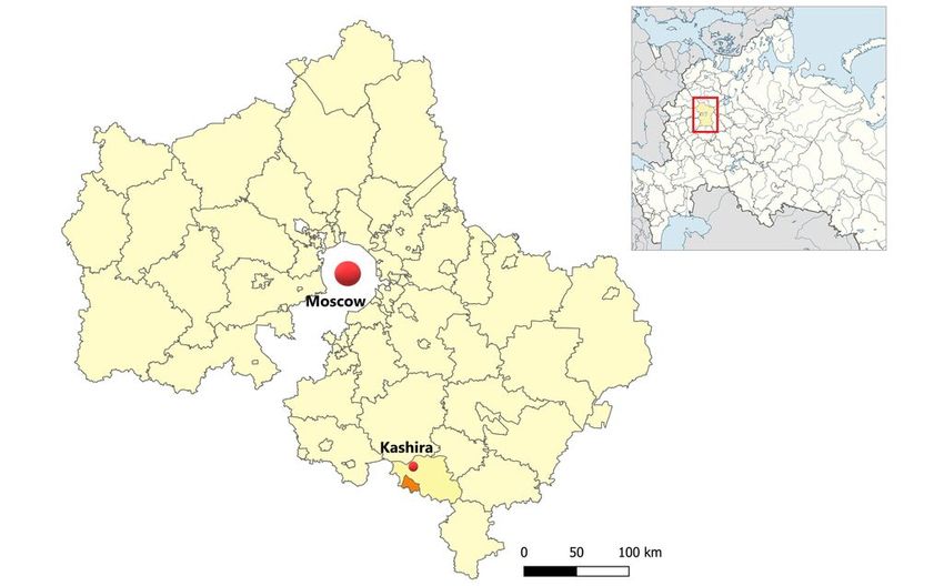
4                                   Anpilogova D, Pakina A

In this study, we investigated abandoned agricultural land in relation to its environmental
benefits. A way to assess these benefits is to analyse the supply of regulation ecosystem
services (ES) available from abandoned arable lands at different stages of plant
succession in comparison with the other types of ecosystems presented in the same
agricultural landscape; i.e. cropland and forest. Regulating ES category integrates the
benefits obtained from the regulation of ecosystem processes (Reid et al. 2005), including
benefits that are important within agricultural landscapes, such as water and erosion
regulation, soil fertility control and pollination.

Materials and Methods
The assessment framework, used in this study, is based on the ES assessment matrix
approach developed by Burkhard et al. (2009). This is a general methodological approach
aimed at evaluating and comparing capacities of different geospatial units to provide ES.
The ES matrix provides a very flexible ES assessment and mapping methodology that can
be applied on all spacial scales (Burkhard and Maes 2017). Thus, it is suitable for
conducting qualitative assessment and mapping of ES at the level of individual ecosystem,
i.e. natural and human-modified ecosystems that comprise agricultural landscapes.

The approach, applied in this study, corresponds with the basic methodological steps of the
ES matrix approach (Burkhard and Maes 2017).

1. Selection of the ES study area.

ES matrix methodology was applied on the study area of 45 km2 situated in Kashira District
at the south-east of the Moscow Region (Fig. 2). This area is representative of the broad-
leaved forest biome of European Russia and reflects land management patterns of the
region. The dominant soil type here is dark grey forest soils*1. As some indicators of ES
are heavily dependent on the soil type (e.g. soil organic matter content), the homogeneity
of the study area in terms of soil type allows the individual regulation ES of different
ecosystemswithin the study area to be made comparable with each other. Dark grey forest
soils of the study area were formed on loess-like loams under broadleaved oak- and
linden-dominated forests (Rysin 2012). Due to relatively high fertility and optimum physical
properties of these soils, they have been used over a long period of time for cultivation of
grains, fruits and industrial crops. Consequently, the major type of land use of the district is
agriculture, whereas forest cover comprises less than 12% of Kashira District area.

2. Selection of relevant geo-biophysical spatial units and land-cover map
creation.

To reveal general patterns of different ecosystems’ capacities to provide regulating ES,
identification of different land-cover types of the study area was conducted. Fig. 3 shows
the land-cover distribution of 2020. The boundaries of lands are based on the relevant
cadastral map. Vegetation cover of the cultivated cropland, abandoned cropland and forest
was identified through the geobotanical research conducted during the selected fields’
Assessing ecosystem services of abandoned agricultural lands: a case study ...       5

inspections (period: June-July 2020). To identify the vegetation of the lands not screened
during the field visits, visual interpretation of high-resolution satelite images (WorldView-2)
was made.

 Figure 2.
 Geographical location of the case study area in the Moscow Region (in orange). In the insert –
 location of the Moscow Region within European Russia.

 Figure 3.
 Land-cover map of the study area (as of 2020).

6 Anpilogova D, Pakina A
Six land-cover categories are represented in the study area:
1) Cropland (36.0% of the study area) – fields of grains (wheat, rye) and annual forage
crops (Fig. 4).
Figure 4.
Cropland. Kashira District, Moscow Region, Russia. Photo: D. Anpilogova, July 2020.
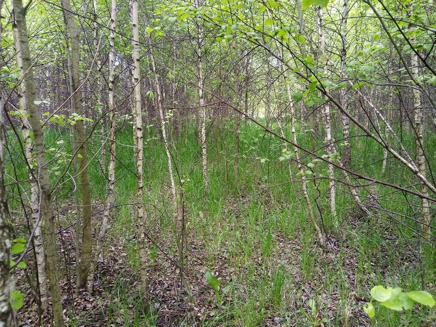
2) Abandoned orchards (4.8% of the study area) – apple trees with grassland vegetation
and young small-leaved trees (Fig. 5).
Figure 5.
Abandoned orchard. Kashira District, Moscow Region, Russia. Photo: D. Anpilogova, June
2020.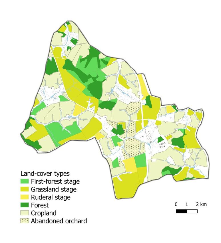
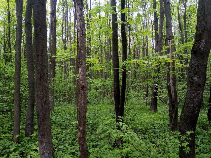
Assessing ecosystem services of abandoned agricultural lands: a case study ...   7

3) Forest (10.7% of the study area) – small-leaved and broadleaved arboreal species
(Betula alba, Populus tremula, Quercus robur, Acer platanoides) (Fig. 6).

 Figure 6.
 Broad-leaved forest. Kashira District, Moscow Region, Russia. Photo: D. Anpilogova, June
 2020.

4) Abandoned agricultural lands on the ruderal stage of post-agrogenic succession
(4.1% of the study area) – for example, Barbarea vulgaris, Sonchus arvensis, Taraxacum
officinale etc. (Fig. 7).

 Figure 7.
 Abandoned land – ruderal stage of succession. Kashira District, Moscow Region, Russia.
 Photo: D. Anpilogova, June 2020.
8 Anpilogova D, Pakina A
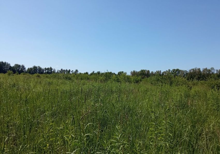
5) Abandoned agricultural lands on the grassland stage of post-agrogenic succession
(18.0% of the study area) – for example, Poa pratensis, Bromus arvensis, Phleum
pratense etc. (Fig. 8).
Figure 8.
Abandoned land – grassland stage of succession. Kashira District, Moscow Region, Russia.
Photo: D. Anpilogova, June 2020.
6) Abandoned agricultural lands on the first-forest stage of post-agrogenic succession
(7.2% of the study area) – Betula alba, Populus tremula, Salix caprea (Fig. 9).
Figure 9.
Abandoned land – young forest stage of succession. Kashira District, Moscow Region, Russia.
Photo: D. Anpilogova, June 2020.
Small-area rural settlements were excluded from the analysis.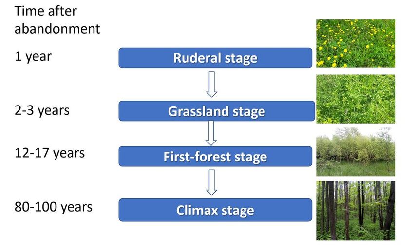
Assessing ecosystem services of abandoned agricultural lands: a case study ...                     9

3. Selection of relevant ES (assessment matrix columns/x-axis) and definition
of suitable indicators.

To assess the environmental benefits of the natural ecosystems developing on the former
agricultural fields, the four ES from the “Regulation and maintenance” section of the
typology CICES v.5.1 (Haines-Young and Potschin 2017) were chosen (further – regulating
ES). These are the vital services that contribute to maintaining the physical, chemical and
biological conditions within the agricultural lanscapes. Since the analysis was undertaken
at the individual ecosystem level, the services that can be assessed on the local level were
selected for the study. The only exception is carbon sequestration and storage, which is a
global ES, although its provision is determined by the joint functioning of individual
ecosystems. These are the services under assessment: regulation of chemical composition
of the atmosphere (subdivided into carbon storage and carbon sequestration), control of
erosion rates, soil quality control and pollination.

The ES selected for the study, along with the corresponding indicators, are listed in
Table 1. There is a wide range of potential indicators that can be used to assess each
individual ES; they can either be indicators of environmental quality or ecosystem attributes
(LIFE 2018). The key factor affecting the choice of a particular indicator was the availability
of suitable data.

 Table 1.
 Regulating ES and their indicators.

Regulation and maintenance ES class            CICES v.5.1   Indicator
                                               code

Regulation of chemical composition of          2.2.6.1       Carbon storage
atmosphere
                                                             Carbon accumulation

Control of erosion rates                       2.2.1.1
(liquid flows)                                                 •         Vegetation cover type
                                                               •         Density of ground cover
                                                               •         Continuity of canopy

Decomposition and fixing processes and their   2.2.4.2       Organic matter content in the upper 20 cm of
effect on soil quality                                       topsoil

Pollination                                    2.2.2.1
                                                               •         Habitat provision for pollinators
                                                               •         Areal coverage of vegetation features
                                                                         supporting pollination

4. Assessment of ES indicators and normalisation of ES indicator values to the
0-5 scale.

One of the main advantages of the ES matrix approach is an opportunity to integrate data
from various sources (Burkhard and Maes 2017). The main data sources used for the ES
assessment within this study were publications of empirical studies conducted in the broad-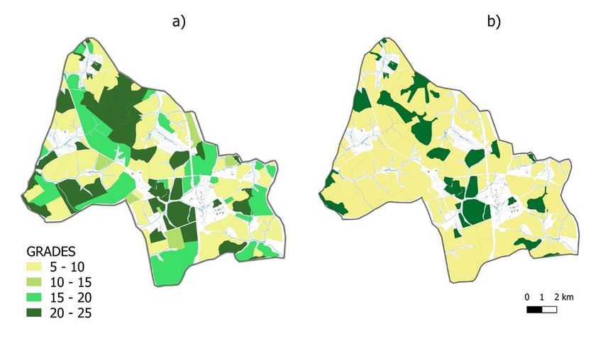
10                                Anpilogova D, Pakina A

leaved sub-zone of the forested zone of European Russia. Quantitative data from literature
were normalised to the relative 0-5 scale using the equal intervals classification method.
The 5-grade assessment scale, used in this study, corresponds with the one proposed by
Burkhard et al. (2009): 0 = no relevant capacity, 1 = low relevant capacity, 2 = relevant
capacity, 3 = medium relevant capacity, 4 = high relevant capacity and 5 = very high
relevant capacity.

When reliable quantitative data on ES indicators were unavailable in literature (e.g. for
pollination), expert scoring was conducted by the authors. Qualitative assessment was
based on the regional soil and hydrological maps, as well as relevant information from
existing studies on ecosystem processes ongoing in the forested zone with dark grey soils.

All the publications upon which the assessment was based are referred to in the
corresponding subsections of the results section.

5. Interlinking geospatial units and scaled ES values in the ES matrix and ES
map creation.

An ES matrix was created to assess and compare the capacities of different ecosystems to
regulate the ES. Six land-cover types of the study area were placed on the y-axis of the
table and the x-axis represents five selected regulating ES. Qualitatively assessed
capacities of different ecosystems to provide individual ES were placed at the
intersections. Scores of individual ES were summed up to get the total regulating ES score
of each land-cover type.

The integrative information, represented in the ES assessment matrix, was then linked to
the land-cover map (Fig. 3) to create an ES assessment map that reveals the existing
spatial distribution patterns of the regulating ES in the study area.

Results
The trends and patterns underlying the capacity of different land-cover types to provide
each of the selected regulating ES are described below. The individual ES scores,
assigned to the geospatial units of the study area, were incorporated into the ES
assessment matrix.

Regulation of chemical composition of atmosphere

The ES of regulation of the chemical composition of the atmosphere is particularly
important in the context of climate change, given that individual ecosystems play a vital
role in the global carbon cycle. For a comprehensive assessment of this ES, it makes
sense to distinguish two significant components: atmospheric carbon accumulation (carbon
balance) and carbon storage in ecosystem pools.
Assessing ecosystem services of abandoned agricultural lands: a case study ...    11

Carbon enters an ecosystem from the atmosphere, mostly through photosynthesis. It is
stored in pools and lost mainly through autotrophic and heterotrophic respiration and
subtraction of phytomass by animals and humans. In addition, the carbon balance of an
ecosystem can be altered by the lateral flux of the organic material. The major carbon
pools in the ecosystems are live aboveground phytomass (e.g. leaves, stems, branches,
scions), dead aboveground organic matter (e.g. grass litter, snag stand, dead branches),
ground litter (debris layer), live below-ground phytomass (e.g. roots) and dead below-
ground organic matter (Bazilevich 1993, Zamolodchikov et al. 2005).

After cultivation and harvesting cease, the natural development of vegetation (especially
arboreal species) promotes carbon accumulation in both above- and below-ground live
phytomass and soil. According to the data of the research conducted on grey forest soils
regions of European Russia, forest ecosystems deposit two to three times more carbon
than ecosystems dominated by grasses because of the development of the forest and
shrub layers (Bazilevich 1993, Lyuri et al. 2010, Karelin et al. 2017). The carbon storage
equals approximately 9.5 kg C·m−2 on croplands and reaches 24 kg C·m−2 in young forests
(i.e. abandoned agricultural lands in the first-forest stage). According to field
measurements, the organic content of post-agrogenic soils begins to increase from the 4th
year after agricultural abandonment, due to the recovery of natural grassland vegetation
(Kurganova et al. 2008). In terms of total carbon storage, the abandoned orchards with
young small-leaved trees are comparable with the abandoned agricultural lands in the first-
forest stage.

The carbon balance, i.e. the net annual flux of carbon from the atmosphere to land per unit
area, is regarded as a key indicator of ecosystem health and dynamics. The carbon
balance of agroecosystems is highly variable and dependent on the management applied
(e.g. fertiliser inputs, tillage, crop sequence etc.). Assuming that the croplands of the study
area were poorly or moderately ameliorated, carbon sequestration of this land-cover type
was significantly lower than that in natural ecosystems because of the harvesting of
primary production. Abandoned fields on grey soils at the ruderal stage of succession
usually emit carbon. Carbon accumulation in soils starts in the 4th year of agricultural
abandonment and declines over time (Kurganova et al. 2017). In contrast, once plant
succession has reached the first-forest stage, the process of carbon accumulation in
perennial parts of plants (shrubs and trees) begins. The ecosystems in this succession
stage demonstrate the highest rates of atmospheric carbon accumulation, which is
explained by the high proportion of young fast-growing trees (Zamolodchikov et al. 2005).
Carbon accumulation reaches its maximum value in 50-year abandoned fields and then
enters a downward trend (Dolman et al. 2012).

Thus, based on the above-mentioned scientific research data, it is possible to attribute the
scores for carbon storage and accumulation to the ecosystems of the study area. These
scores are reflected in the corresponding columns of the ES assessment matrix.
12                                   Anpilogova D, Pakina A

Control of erosion rates

As the study area is characterised by a humid climate, its soils are mostly susceptible to
erosion associated with water flows. The specific ES of protection against water erosion is
particularly important for agricultural areas, considering that the displacement of upper soil
layers from the fields would be detrimental, not only for water ecosystems (e.g.
sedimentation and eutrophication of ponds and rivers), but also for agricultural productivity.
At the same time, human farming practices dramatically diminish the resistance of soils to
detachment and transport of particles.

The water erosion rate (i.e. the ratio of soil loss) is affected by several factors, but allows
for compatibility of the ecosystems within the study area in terms of climate conditions,
topographic position and soil type; the erosion vulnerability of different land-cover types
mainly depends on vegetation cover for the reasons set out below.

The first function of vegetation cover is mechanical protection of the soil from the impact of
flowing and falling water. Serving as an interface between the atmosphere and the soil,
aboveground plant parts, such as leaves and stems, partially absorb the energy of the
raindrops and flowing surface waters. This capacity to reduce the impact of rainfall
depends on the ground cover density and canopy continuity. In turn, below-ground plant
parts, such as root systems and underground stems, mechanically strengthen the soil and
protect it from wash-off (Erencin 2000).

The second function of vegetation cover in terms of erosion risk is water infiltration support.
In CICES v.5.1 “Control of erosion rates”, ES belongs to the “Regulation of baseline flows
and extreme events” group (Haines-Young and Potschin 2017). The capacity of the
ecosystem to provide erosion control ES is directly correlated with the other ES of the
same group – “Hydrological cycle and water flow regulation” (code 2.2.1.3), which is
provided at the river basin level. The key attribute of this ES is the capacity of the soil to
decrease the amplitude of seasonal runoff fluctuations by transferring surface runoff into
groundwater runoff. This capacity depends on the permeability of soil to snowmelt and
rainwater, which is, other things being equal, correlated with vegetation cover type. Ground
vegetation cover, together with ground litter, sustains soil infiltration capacity by protecting
surface pores. At the same time, root systems facilitate water penetration deep into the
soil. Therefore, erosion risk mitigation is associated with the root zone depth within the soil
profile. The root zone depth potential in dark grey soils of the study area is not restricted by
the solid illuvial horizon. The observed root depth of the forest plant community on dark
grey forest soils reaches 2-3 m, root zone depth of young forest ecosystems, namely
abandoned lands at the first-forest stage of succession, are within 1.5 m and the root zone
depth of grass ecosystems usually does not exceed 0.6-0.7 m (Voronkov 1988, He et al.
2015, Yanai et al. 2017).

These root zone depth data help to reveal typical patterns of capacities of different
ecosystems in the study area to provide water erosion control ES. Mature forest
ecosystems have the deepest root systems. Moreover, ground litter and increased snow
accumulation in forests support soil infiltration capacity by inhibiting the straight freezing of
Assessing ecosystem services of abandoned agricultural lands: a case study ...    13

soil in winter (Voronkov 1988, Nasir Ahmad et al. 2020). It should also be noted that tree
canopy interception in deciduous forests reduces the volume of rainwater reaching the soil
surface (Markov and Nedkov 2016). The foregoing indicates a maximum capacity in
mature forest ecosystems to provide an erosion control function (score 5), followed by
young forests (score 4).

Grass ecosystems, developed on abandoned fields, also have considerable potential for
erosion risk mitigation (score 3). Grass litter and stag stand protect soil from straight
freezing, making the soil more permeable during snow melting. Organic mats formed by
permanent grass cover mechanically protect the soil from removal with water flows
(Voronkov 1988).

When it comes to the assessment of the erodibility of croplands, the factor of agronomical
practices comes to the forefront. Based on the available data from literature, croplands
under standard fallow and clean-tilled conditions show the highest water erosion rate,
although actual soil loss from cropland is not that high and largely depends on farming
techniques (e.g. low or zero tillage, winter crops, crop sequence, crop residue
management etc.) (Markov and Nedkov 2016). However, because croplands in the study
area are subject to mechanical tillage and lack permanent above-ground vegetation cover,
it can be concluded that the erosion control service of croplands is at a minimum compared
to the ES provided by other land-cover types (score 1).

Decomposition and fixing processes and their effect on soil quality

Within the CICES v.5.1 typology “Decomposition and fixing processes and their effect on
soil quality”, ES is included in the “Regulation of soil quality” group. This ES is related to
the soil fertility regulation and can be assessed, based on the decomposed organic matter
content of the topsoil.

Dark grey forest soils in the study region were developed under goutweed-oak forests. The
estimated depth of the humus-accumulated horizon in this soil type reaches 40 cm. The
distinctive feature of grey forest soils is intensive biological accumulation, which causes the
humus accumulation process to prevail over the ground litter accumulation process,
increasing soil fertility (Kurganova et al. 2018).

Conversion of broadleaved forests into arable land disrupts natural humus accumulation
processes. The organic material supply of soil substantially decreases and the biogenic
elemental ratio changes (Polyakova 2012). Additionally, real tillage treatment of soil
increases soil aeration and promotes intensive humus mineralisation. The humus content
of the plough horizon is twice as low as that in the layer of the same depth of virgin dark
grey forest soil (Aliphanov 1979).

Agricultural land abandonment, followed by restoration of natural vegetation, leads to
gradual restoration of the natural structure of dark grey forest soils, improvement of soil
agronomical properties, accumulation of organic matter in the upper part of the former
plough horizon and increased microbiological activity (Baeva et al. 2017, Kurganova et al.
14                                   Anpilogova D, Pakina A

2018). This post-agrogenic soil restoration process results from the cessation of plant
material removal with harvest, active sod formation at the grass stage of succession and
input of leaf litter from the arboreal vegetation at deciduous forest stages. Within two years
after agricultural abandonment (ruderal stage of succession), the humus content of the
former plough horizon either remained unchanged or decreased (in the case of
ameliorated cropland). In the grassland stage, humus content starts showing gradual
growth, reaching its maximum value in mature forests (Lyuri et al. 2010).

Selected field data on the humus content of the upper 20-cm layer of different land-cover
types on dark grey forest soils of European Russia are available in literature, which makes
possible the use of humus content as an indicator to assess and compare the capacities of
different ecosystems of the study area to provide soil quality regulation ES. The average
humus content of the young small-leaved forest grown on the former cropland was 4.2%,
whereas in mature deciduous forest, it reaches 5.2% (Polyakova 2012). The humic organic
content of cropland is highly variable depending on farming practices such as tillage
technique, fertiliser inputs and crop rotation; however, the natural soil fertility of croplands
is approximately 3.5%.

The arguments made above allow us to assign to the different ecosystems in the study
area the scores reflected in the assessment matrix.

Pollination

Within the CICES v.5.1 classification, pollination ES belongs to the group “Lifecycle
maintenance, habitat and gene pool protection” (Haines-Young and Potschin 2017).
Although most crops in the study area are self- or wind-pollinated (e.g. wheat and rye),
insect pollination is still required for the sustainable production of plants, such as peas and
rape. Moreover, because the average proportion of animal-pollinated (mostly insect-
pollinated) wild plant species in temperate zone communities reaches 78% (Ollerton et al.
2011), the stability of ecosystem processes and resilience of all the natural ecosystems of
the study area are highly dependent on the provision of pollination services. The ecological
sustainability of the whole landscape is defined as the health of the individual ecosystems
comprising it.

The process underpinning pollination ES is relatively small-scale, given that minor
landscape elements, such as ecotones at forest borders, single-trees, hedgerows including
field margins are important for its provision (Burkhard and Maes 2017). Therefore,
assessing and mapping pollination ES at an ecosystem level is a complex task and there
exist several approaches to solving it. In the projects based on the analytical framework
developed under the EU initiative, "Mapping and Assessment of Ecosystems and their
Services (MAES)", a number of indicators of this ES for different types of land-cover are
proposed (Burkhard and Maes 2017). These indicators include the distribution of
heathlands and other habitats for bees, modelled honey production, pollinator species
richness, number of beehives, areal coverage of vegetation features supporting pollination
etc. Most of the indicators, besides directly measuring the diversity and density of
pollinators, are related either to pollinator habitat or pollinator forage. Due to the lack of up-
Assessing ecosystem services of abandoned agricultural lands: a case study ...         15

to-date data on pollinator populations in the study area, indirect indicators were used in this
study.

It is feasible to consider two criteria for the ecosystems under assessment. First, the
abundance of pollinator populations is conditional on habitat provision for pollinators, i.e.
the existence of undisturbed areas for insect nesting (e.g. beehives). Second, pollination
services depend on the foraging activity of pollinating insects and, thus, are highly
influenced by the availability of entomophilous flowering plants, plant species diversity of
the ecosystem and bloom period duration (Gaeva 2015, LIFE 2018). Both indicators are
conditional on land-cover and land-use.

Based on the two above-mentioned criteria, it can be concluded that pollination service is
highest in forests, both young and mature, followed by grass ecosystems developed on
abandoned fields (ruderal and grassland stages). Additional evidence of the high capacity
of deciduous forest ecosystems of European Russia to provide pollination ES, specified in
scientific research, is high-level honey production in these ecosystems (Gaeva 2015). On
the other hand, human intervention, such as tillage or overgrazing, leads to pollinator
habitat devastation. Therefore, cropland is characterised by a low capacity to provide
pollination ES, especially when the cultivated crops are wind-fertilised, as it is in many
fields in the study area.

Assessment matrix

Based on the individual ES grade assignments made above, an assessment matrix was
generated. This matrix reflects the potential of different land-cover units to regulate
ecosystem services.

In Table 2, we present the assessment of the ES capacity of the study area. In particular,
arboreal ecosystems show relatively high capacity. The maximum total score is obtained in
the case of forested land, followed by young forest grown on abandoned fields and
abandoned orchards with young small-leaved trees. The total results, reflected in the
matrix, allow us to conclude that the total capacity of post-agrogenic ecosystems to provide
regulation services is positively related to time since abandonment. The croplands had the
lowest total score and appeared to be a recipient, rather than a source of regulating ES.

 Table 2.
 Regulating ES assessment matrix.

Land-cover type      Regulating ES

                     Pollination Water erosion   Soil quality   Carbon    Carbon         Σ Regulating
                                 protection      regulation     storage   accumulation   ES

Cropland             1          1                3              2         1              8

Abandoned orchards   5          4                4              4         4              21

Forest               5          5                5              5         3              23
16 Anpilogova D, Pakina A
Land-cover type Regulating ES
Pollination Water erosion Soil quality Carbon Carbon Σ Regulating
protection regulation storage accumulation ES
Abandoned land – 4 3 3 2 0 12
ruderal stage
Abandoned land – 4 3 3 2 4 16
grassland stage
Abandoned land – 5 4 4 4 5 22
first-forest stage
Combining the assessment matrix (Table 2) with the land-cover map (Fig. 3) allows for the
creation of two ecosystem service maps (Fig. 10). In Fig. 10a, we present the actual
patterns of regulation of the spatial distribution of ES in the study area. The capacity of the
landscape to provide ecosystem services in the case of the return of all abandoned lands
to agricultural use is depicted in Fig. 10b.
Figure 10.
Regulation ES assessment maps:
a) Actual ES distribution;
b) ES distribution in case of return of all the abandoned fields to cultivation.
Discussion
The conducted analysis demonstrates that the ES matrix approach appears to be an
effective instrument for analysing and assessing the diversity of abandoned agricultural
lands in order to manage land use structure at the regional and local level. The approach
can be considered as a powerful tool to assess trade-offs between ES (Seppelt et al. 2013
), to visualise development pathways and future options to identify contrasting trends (GornAssessing ecosystem services of abandoned agricultural lands: a case study ... 17 et al. 2018), especially due to adaptation of land use to climate change, as well as in regional planning to support decision-making. However, scenario development, based on the ES matrix approach, is frequently confronted with uncertainties due to a high level of complexity and unforeseeable dynamics in socio-ecological systems and data gaps (Burkhard et al. 2012, Burkhard and Maes 2017). The limits and uncertainties of the ES matrix approach have been listed, for instance in Hou et al. (2013), Campagne et al. (2017). Nevertheless, the availability of a wide range of scientific publications in this region (including Kurganova et al. 2008, Karelin et al. 2017, Kalinina et al. 2019), describing natural properties of soils, vegetation cover and other landscape characteristics, as well as agro-ecological characteristics, allowed us to choose the most relevant ecosystem services mentioned above (see Materials and Methods) to assess: regulation of chemical composition of the atmosphere, control of erosion rates, soil quality control and pollination. The methodology is intended to be further developed through the introduction of a weighting procedure that accounts for individual ecosystem services with regard to their relevance to the agricultural landscape with a high proportion of abandoned fields. At least, a significance of abandoned lands' ecosystem services with an emphasis on regulatory ones, such as CO2 absorption, can be predicted to increase. The climate change trends observed in recent years in the European part of Russia confirm the average annual air temperature anomaly (deviation from the average for 1961-90) which was +3.22°C in 2020 (Hydrometcenter 2021). The weight of regulatory services is likely to grow in this regard making adjustments to the methodology of the assessments. Another important point in the development of the considered approach is its integration into economic assessments. Despite the approach not focusing today on the economic evaluation of ES, the results demonstrate clear patterns of ES distribution that are useful for decision-making in agricultural land-use. The relatively low forestation degree of Kashira District, located in the forested zone of the European Russia, determines the rising weight of such ecosystem services as biodiversity maintenance and other natural properties of forest ecosystem restoration and its economic significance. The matrix approach in this regard will obviously be subject to changes, while its application in land use practice will continue to be in demand. Conclusions The assessment of regulating ecosystem services with the ES matrix approach revealed that ecosystems in the study area vary in their ability to support the ecological integrity and stability of the agricultural landscape. Such a conclusion is crucial for the land use management in long-developed arable regions like Kashira District. Facing modern climate and social challenges, effective land use management should be focused on ES accounting. Since the Kashira District is characterised by a relatively high proportion of agricultural land (over 60%) and a rather low forest area (12%), the assessment of ES allows us to achieve a reasonable balance of lands involved in agriculture and abandoned lands.
18                                 Anpilogova D, Pakina A

The results of our research show that the highest capacity to provide regulating ES is in the
forest ecosystems. By contrast, croplands, as the only human-modified land-cover type,
have a relatively low capacity to regulate ES. Concerning the ecosystems developed on
abandoned agricultural land, their supply of regulation ES increases with time since
abandonment. In the study area, regulating ES supply of the abandoned fields attains its
maximum at the first forest stage of post-agrogenic plant succession. In terms of regulating
ES ecosystems at the first forest stage, lands are comparable to the lands covered by
mature forests. Thus, it can be concluded that land abandonment contributes to
environmental benefits because of the vegetation recovery that compensates for the
historical loss of large areas of broadleaved forests. At the same time, the return of all
uncultivated fields to agricultural use causes a substantial decrease in the ecological value
of the study area.

All these arguments should be taken into account when addressing the problem of land
abandonment and deciding what management strategy would be appropriate for the
addressed agricultural landscape: renewal of crop cultivation, active reforestation or
passive revegetation. The trend of population decline in rural areas of European Russia in
the 2000s and the weak recovery since 2010 give no reason for an increase in the
involvement of land in agricultural turnover, while maintaining ecosystem services
represents a great benefit. In this regard, passive vegetation restoration can be considered
as a noteworthy direction of land use. To obtain practical recommendations, further
application of the ES matrix approach has to integrate more confidence analysis with focus
on the most appropriate assessment methods for each individual ES or their groups
(Campagne et al. 2017). Nevertheless, the assessment of ecosystem services with the ES
matrix approach is a suitable tool for determining the main directions in regional land use
planning.

Acknowledgements
This research was performed according to the Development programme of the
Interdisciplinary Scientific and Educational School of M.V. Lomonosov Moscow State
University "Future Planet and Global Environmental Change".

Hosting institution
Lomonosov Moscow State University, Faculty of Geography, Department of Environmental
Management.

References

 •     Aliphanov VM (1979) Изменение серых лесных почв при сельскохозяйственном
       использовании [Transformation of gray forest soils with agricultural use].
       Pochvovedenie 1: 37‑47. [In Russian].
Assessing ecosystem services of abandoned agricultural lands: a case study ... 19
• Baeva YI, Kurganova IN, Lopes de Gerenyu VO, Pochikalov AV, Kudeyarov VN (2017)
Changes in physical properties and carbon stocks of gray forest soils in the southern
part of Moscow region during postagrogenic evolution. Eurasian Soil Science 50 (3):
327‑334. https://doi.org/10.1134/s1064229317030024
• Bazilevich NI (1993) Биологическая продуктивность экосистем Северной Евразии.
[Biological productivity of ecosystems in Northern Eurasia]. Nauka, Moscow, 293 pp.
[In Russian].
• Buehnemann W (1980) Effects on the environment of the abandonment of agricultural
land. COMMISSION OF THE EUROPEAN COMMUNITIES, Brussels-Luxembourg, 19
pp. [In English]. [ISBN 92-825-1096-4]
• Burkhard B, Kroll F, Müller F, Windhorst W (2009) Landscapes' capacities to provide
ecosystem services - A concept for land-cover based assessments. Landscape Online
15: 1‑22. https://doi.org/10.3097/lo.200915
• Burkhard B, Kroll F, Nedkov S, Müller F (2012) Mapping ecosystem service supply,
demand and budgets. Ecological Indicators 21: 17‑29. https://doi.org/10.1016/j.ecolind.
2011.06.019
• Burkhard B, Maes J (2017) Mapping Ecosystem Services. Pensoft Publishers, Sofia.
https://doi.org/10.3897/ab.e12837
• Campagne CS, Roche P, Gosselin F, Tschanz L, Tatoni T (2017) Expert-based
ecosystem services capacity matrices: Dealing with scoring variability. Ecological
Indicators 79: 63‑72. https://doi.org/10.1016/j.ecolind.2017.03.043
• Cursach J, Rita J, Gómez-Martínez C, Cardona C, Capó M, Lázaro A (2020) The role of
landscape composition and heterogeneity on the taxonomical and functional diversity of
Mediterranean plant communities in agricultural landscapes. PLOS ONE 15 (9).
https://doi.org/10.1371/journal.pone.0238222
• Dolman AJ, Shvidenko A, Schepaschenko D, Ciais P, Tchebakova N, Chen T, van der
Molen MK, Belelli Marchesini L, Maximov TC, Maksyutov S, Schulze E- (2012) An
estimate of the terrestrial carbon budget of Russia using inventory-based, eddy
covariance and inversion methods. Biogeosciences 9 (12): 5323‑5340. https://doi.org/
10.5194/bg-9-5323-2012
• Erencin Z (2000) C-Factor mapping using Remote Sensing and GIS : a case study of
Lom Sak /Lom Kao, Thailand. Geographisches Institut der Justus-Liebig-Universität
Giessen
• Gaeva D (2015) Опыление как экосистемная услуга в аграрном
природопользовании [Pollination ecosystem service in agricultural land-use]. IKBFU's
Vestnik (1)19‑34. [In Russian].
• Gorn L, Kleemann J, Fürst C (2018) Improving the Matrix-Assessment of Ecosystem
Services Provision—The Case of Regional Land Use Planning under Climate Change
in the Region of Halle, Germany. Land 7 (2). https://doi.org/10.3390/land7020076
• Haines-Young R, Potschin MB (2017) Common International Classification of
Ecosystem Services (CICES) V.5.1 and Guidance on the Application of the Revised
Structure. https://doi.org/10.3897/oneeco.3.e27108
• He H, Dyck M, Si B, Zhang T, Lv J, Wang J (2015) Soil freezing–thawing characteristics
and snowmelt infiltration in Cryalfs of Alberta, Canada. Geoderma Regional 5: 198‑208.
https://doi.org/10.1016/j.geodrs.2015.08.00120 Anpilogova D, Pakina A
• Hou Y, Burkhard B, Müller F (2013) Uncertainties in landscape analysis and ecosystem
service assessment. Journal of Environmental Management 127 https://doi.org/
10.1016/j.jenvman.2012.12.002
• Hydrometcenter (2021) Доклад об особенностях климата на территории Российской
Федерации за 2020 год. [Report on the climate patterns in the territory of the Russian
Federation for 2020]. Hydrometcenter of Russia, Moscow. [In Russian].
• Kalinina O, Goryachkin SV, Lyuri DI, Giani L (2015) Post-agrogenic development of
vegetation, soils, and carbon stocks under self-restoration in different climatic zones of
European Russia. CATENA 129: 18‑29. https://doi.org/10.1016/j.catena.2015.02.016
• Kalinina O, Cherkinsky A, Chertov O, Goryachkin S, Kurganova I, Lopes de Gerenyu V,
Lyuri D, Kuzyakov Y, Giani L (2019) Post-agricultural restoration: Implications for
dynamics of soil organic matter pools. CATENA 181 https://doi.org/10.1016/j.catena.
2019.104096
• Karelin DV, Goryachkin SV, Kudikov AV, Lopes de Gerenu VO, Lunin VN, Dolgikh AV,
Lyuri DI (2017) Changes in carbon pool and CO2 emission in the course of
postagrogenic succession on gray soils (Luvic Phaeozems) in European Russia.
Eurasian Soil Science 50 (5): 559‑572. https://doi.org/10.1134/s1064229317050076
• Kurganova I, Gerenyu VLd, Mostovaya A, Ovsepyan A, Telesnina V, Lichko V, Baeva Y
(2018) The effect of reforestation on microbial activity in post-agrogenic soils in
European part of Russia. Lesovedeniye 1: 3‑23. https://doi.org/10.7868/s002411
4818010011
• Kurganova IN, Lopes de Gerenyu VO, Myakshina TN, Sapronov DV, Lichko VI,
Yermolaev AM (2008) Changes in the carbon stocks of former croplands in Russia.
Zemes Uko Mokslai 15 (4): 10‑15. [In English].
• Kurganova IN, Kudeyarov VN, Gerenyu LD (2017) Updated estimate of carbon balance
on Russian territory. Tellus B: Chemical and Physical Meteorology 62 (5): 497‑505.
https://doi.org/10.1111/j.1600-0889.2010.00467.x
• Lasanta T, Arnáez J, Nadal-Romero E (2019) Soil degradation, restoration and
management in abandoned and afforested lands. Soil Degradation, Restoration and
Management in a Global Change Context71‑117. https://doi.org/10.1016/bs.apmp.
2019.07.002
• LIFE (Ed.) (2018) Assessing ecosystems and their services in LIFE projects, Guide for
beneficiaries. European Commission. URL: https://ec.europa.eu/environment/archives/
life/toolkit/pmtools/life2014_2020/documents/life_ecosystem_services_guidance.pdf
• Lyuri DI, Goryachkin SV, Karavaeva NA, Denisenko EA, Nefedova TG (2010)
Динамика сельскохозяйственных земель России в ХХ веке и постагрогенное
восстановление растительности и почв. [Dynamics of agricultural lands of Russia in
XX century and postagrogenic restoration of vegetation and soils.]. GEOS, Moscow,
416 pp. [In Russian].
• Markov B, Nedkov S (2016) Mapping of erosion regulation ecosystem services. 6th
International Conference on Cartography and GIS, Albena, Bulgaria, 13-17 June 2016.
Proceedings [ISBN 1314-0604].
• Nasir Ahmad NSB, Mustafa FB, Muhammad Yusoff S@Y, Didams G (2020) A
systematic review of soil erosion control practices on the agricultural land in Asia.
International Soil and Water Conservation Research 8 (2): 103‑115. https://doi.org/
10.1016/j.iswcr.2020.04.001Assessing ecosystem services of abandoned agricultural lands: a case study ... 21
• Navarro L, Pereira H (2012) Rewilding Abandoned Landscapes in Europe. Ecosystems
15 (6): 900‑912. https://doi.org/10.1007/s10021-012-9558-7
• Nefedova T, Medvedev A (2020) Shrinkage of Active Space in Central Russia:
Population Dynamics and Land Use in Countryside. Izvestiya Rossiiskoi Akademii Nauk
Seriya Geograficheskaya 84 (5): 645‑659. [In Russian]. https://doi.org/10.31857/
s258755662005012x
• Ollerton J, Winfree R, Tarrant S (2011) How many flowering plants are pollinated by
animals? Oikos 120 (3): 321‑326. https://doi.org/10.1111/j.1600-0706.2010.18644.x
• Polyakova NV (2012) Эволюция серых лесных почв в агроландшафтах Северной
лесостепи. [Evolution of gray forest soils in agricultural landscapes of the nothern
forest steppe]. RSAU-MTTA, Moscow, 338 pp. [In Russian].
• Prévosto B, Kuiters L, Bernhardt-Römermann M, Dölle M, Schmidt W, Hoffmann M, Van
Uytvanck J, Bohner A, Kreiner D, Stadler J, Klotz S, Brandl R (2011) Impacts of Land
Abandonment on Vegetation: Successional Pathways in European Habitats. Folia
Geobotanica 46 (4): 303‑325. https://doi.org/10.1007/s12224-010-9096-z
• Reid W, Carpenter S, Mooney HA, Chopra K (2005) Ecosystems and Human Well-
being – Synthesis: A Report of the Millennium Ecosystem Assessment. Island Press,
Washington, 137 pp.
• Rey Benayas JM (2007) Abandonment of agricultural land: an overview of drivers and
consequences. CAB Reviews: Perspectives in Agriculture, Veterinary Science, Nutrition
and Natural Resources 2 (057). https://doi.org/10.1079/pavsnnr20072057
• Romanenko AG (Ed.) (2008) Агроэкологическое состояние и перспективы
использования земель России, выбывших из активного сельскохозяйственного
оборота. [Agroecological status of lands withdrawn from active agricultural turnover and
prospects for their further use]. Rosinformagrotekh, Moscow, 110 pp. [In Russian].
• Rysin LP (2012) Леса Подмосковья. [Forests of Moscow Region]. KMK Scientific
Press Ltd, Moscow, 256 pp. [In Russian].
• Seppelt R, Lautenbach S, Volk M (2013) Identifying trade-offs between ecosystem
services, land use, and biodiversity: a plea for combining scenario analysis and
optimization on different spatial scales. Current Opinion in Environmental Sustainability
5 (5): 458‑463. https://doi.org/10.1016/j.cosust.2013.05.002
• Voronkov NA (1988) Роль лесов в охране вод. [Role of the forests in water protection].
Hydrometeoizdat, Leningrad, 286 pp. [In Russia].
• Ward EB, Doroski DA, Felson AJ, Hallett RA, Oldfield EE, Kuebbing SE, Bradford MA
(2021) Positive long-term impacts of restoration on soils in an experimental urban
forest. Ecological applications : a publication of the Ecological Society of America 31
(5): e02336. https://doi.org/10.1002/eap.2336
• Yanai Y, Iwata Y, Hirota T (2017) Optimum soil frost depth to alleviate climate change
effects in cold region agriculture. Scientific reports 7: 44860. https://doi.org/10.1038/
srep44860
• Zamolodchikov DG, Utkin AI, Korovin GN, Chestnykh OV (2005) Dynamics of Carbon
Pools and Fluxes in Russia's Forest Lands. Russian Journal of Ecology 36 (5):
291‑301. https://doi.org/10.1007/s11184-005-0076-022 Anpilogova D, Pakina A
Endnotes
*1 In Russian national soil classification system – dark soils rich in organic matter with a
high base saturation in the upper metre of the soil. In World reference base for soil
resources (2014) corresponds to Greyzemic Phaeozems.You can also read