Assessment of C-Band Mobile Telecommunications Interference Impact on Low Range Radar Altimeter Operations Errata 1 - RTCA
←
→
Page content transcription
If your browser does not render page correctly, please read the page content below
RTCA, Inc.
                               th
                        1150 18 Street, NW, Suite 910
                           Washington, DC 20036
                                    USA

          Assessment of C-Band Mobile
    Telecommunications Interference Impact on
     Low Range Radar Altimeter Operations
                    Errata 1
                     (RTCA Paper No. 201-21/PMC-2183)

Errata 1                                                Prepared by: SC-239
September 16, 2021                                       ©2021, RTCA, Inc.
Copies of this document may be obtained from:
RTCA, Inc.
1150 18th Street, NW, Suite 910
Washington, DC 20036-4001, USA
Telephone: 202-833-9339
Facsimile: 202-833-9434
Internet: rtca.org
Please visit the RTCA online store for document pricing and ordering information.FOREWORD
This document was prepared by Special Committee 239 (SC-239) and approved by the RTCA Program
Management Committee (PMC) on September 16, 2021.
RTCA, Incorporated is a not-for-profit corporation formed to advance the art and science of aviation and
aviation electronic systems for the benefit of the public. The organization functions as a Standards
Development Organization and develops consensus based recommendations on contemporary aviation
issues. RTCA's objectives include, but are not limited to:
coalescing aviation system user and provider technical requirements in a manner that helps
government and industry meet their mutual objectives and responsibilities;
analyzing and recommending solutions to the system technical issues that aviation faces as it
continues to pursue increased safety, system capacity, and efficiency;
developing consensus on the application of pertinent technology to fulfill user and provider
requirements, including development of minimum operational performance standards for electronic
systems and equipment that support aviation; and
assisting in developing the appropriate technical material upon which positions for the International
Civil Aviation Organization and the International Telecommunication Union and other appropriate
international organizations can be based.
The organization's recommendations are often used as the basis for government and private sector decisions
as well as the foundation for many Federal Aviation Administration Technical Standard Orders.
Since RTCA is not an official agency of the United States Government, its recommendations may not be
regarded as statements of official government policy unless so enunciated by the U.S. government
organization or agency having statutory jurisdiction over any matters to which the recommendations relate.
Disclaimer
This publication is based on material submitted by various participants during the SC approval process.
Neither the SC nor RTCA has made any determination whether these materials could be subject to valid
claims of patent, copyright or other proprietary rights by third parties, and no representation or warranty,
expressed or implied is made in this regard. Any use of or reliance on this document constitutes an
acceptance thereof "as is” and is subject to this disclaimer.This Page Intentionally Left Blank
EXECUTIVE SUMMARY
This document contains the updated page to replace in the longitude listed in Table 8-2 of the Assessment
of C-Band Mobile Telecommunications Interference Impact on Low Range Radar Altimeter Operations
which was published by the PMC on October 7, 2020.
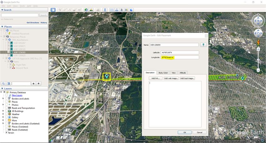
The longitude listed in Table 8-2 for one of the 5G base stations considered in the Instrument Approach
Procedure scenario is incorrect. This error was identified by multiple parties (both internal and external to
SC-239) who noticed the inconsistency between this tabulated longitude value and the location of the base
station shown on the map in Figure 8-1. The correct longitude value for the base station ASR 1256593
which should be listed in Table 8-2 is 87 degrees, 52 minutes, 25 seconds West (rounded to the nearest
arcsecond).
When the error was brought to the attention of SC-239 leadership, the analysis script for this scenario
(which was used to compute and plot interference levels, as presented in Sections 10.2 and D.2.2 of the
report) was checked. It was confirmed that the script used the correct longitude value of 87 degrees, 52
minutes, 24.6 seconds West for this base station, and therefore none of the results or conclusions presented
in the report for this scenario were impacted by the error. The error was simply a transcription error in Table
8-2.
The following Google Earth screenshot shows a confirmation of the correct longitude for this base station:
No other content was changed.
iThis Page Intentionally Left Blank
TABLE OF CONTENTS

1   REPLACEMENT TABLE 8-2............................................................................................................. 1

                                                                  iii
1
1 REPLACEMENT TABLE 8-2
Please replace Table 8-2 on page 46 of the report with the following table:
Table 8-1: Instrument Approach Procedure Scenario Base Station Information
FCC Structure Elevation Height
Latitude Longitude
Registration (MSL) (AGL)
1053267 41° 59’ 06” N 87° 49’ 26” W 759 ft 103 ft
1058071 41° 59’ 04” N 87° 47’ 09” W 740 ft 115 ft
1209185 41° 59’ 07” N 87° 50’ 31” W 774 ft 134 ft
1256593 87° 5248’ 2550” 718 ft 78 ft
41° 59’ 02” N
W
1280620 41° 58’ 58” N 87° 46’ 59” W 713 ft 90 ft
©2021 RTCA, IncThis Page Intentionally Left Blank
You can also read