ATASCOSA CENTRAL APPRAISAL DISTRICT - Reappraisal Plan Appraisal years 2021 and 2022 - Atascosa ...
←
→
Page content transcription
If your browser does not render page correctly, please read the page content below
Atascosa Central Appraisal District
                            Michelle L. Berdeaux RPA, RTA, CTA, CCA
                            Chief Appraiser
                            P. 0. Box 600
                            Pleasanton, TX. 78064
                            Tel: 830-569-8326
                            Fax: 830-569-8342

 ATASCOSA CENTRAL APPRAISAL DISTRICT

                           Reappraisal Plan
                     Appraisal years 2021 and 2022

Approved 9-10-2020
Table of Contents
Executive Summary 4
Tax Code Requirement
The Written Plan 5
Plan for Periodic Reappraisal 5
Market Value 6
Revaluation Policy (Reappraisal Cycle)
Residential 7
Commercial 7
Business Personal Property 7
Industrial Utilities and Minerals 7
2021 Appraisal Calendar 8
2022 Appraisal Calendar 11
Appraisal Zone Map 15
Elements of Reappraisal
Performance Analysis 16
Reappraisal Decision 16
Analysis of Available Resources 16
Planning and Organization 16
System Development 16
Pilot Study 16
Data Collection 16
Production of Values 17
Preparation of Assessment Role 17
Final Performance Analysis 17
Data maintenance 17
New Construction 17
Periodic Inspection 17
Value Updates 17
Current Resources
Personnel Resources 18
Staff Education and Training 18
Data 18
Information System 19
Shared Appraisal District Boundaries 20
Independent Performance Test 20
Appraisal Activities
Data Collection/Validation 21
Sources of Data 21
Field Review 22
Performance Test 23
2Residential Valuation Process
Valuation Approach 23
Valuation and Statistical Analysis 24
Individual Value and Review Procedures 26
Performance Tests 26
Treatment of Residence Homestead 27
Agricultural Valuation Process
Approach to Values 27
Wildlife Management 27
Field Review 28
Commercial Valuation Process
Valuation Approach 28
Valuation and Statistical Analysis 29
Individual Value and Review Procedures 31
Performance Tests 32
Industrial Utility and Mineral Valuation Process 33
Business Personal Property Valuation Process
Valuation Approach 33
Data Collection/Validation 34
Valuation and Statistical Analysis 34
Depreciation Schedule and Trending Factors 35
Individual Value Review Procedures 35
Performance Tests 36
Value Defense 37
Certification Statement 38
3Atascosa Central Appraisal District
2021-2022 Mass Appraisal Report
_______________________________________________________________________
EXECUTIVE SUMMARY
The Atascosa Central Appraisal District (ACAD) has prepared and published this report to provide our citizens
and taxpayers with a better understanding of the district's responsibilities and activities. This report has several
parts: An Executive Summary, Tax Code requirement for reappraisal plans, Elements of Reappraisal and then
several sections describing the appraisal effort by the appraisal district.
The ACAD is a political subdivision of the State of Texas created for schools, cities and special districts
pursuant to Senate Bill 621, which was passed by the 66th Legislative in 1979. HJR 98, approved by the voters
in November 1980 as Proposition 3 on the general election ballot amending Article VIII, Section 18 of the
Texas Constitution, was implemented by the passage of HB30 in 1981, which mandated counties to participate
in the appraisal district. HB30 became effective August 14, 1981. The ACAD commenced operations in 1981
and, as required by law furnished their first appraisal roll for each taxing jurisdiction within the boundaries of
the ACAD. The provisions of the Texas Property Tax Code govern the legal, statutory, and administrative
requirements of the appraisal district. A member board of directors, appointed by the taxing units within the
boundaries of ACAD, constitutes the district's governing body. The Chief Appraiser, appointed by the board of
directors, is the chief administrator and chief executive officer of the appraisal district.
The appraisal district is responsible for local property tax appraisal and exemption administration for 15
jurisdictions or taxing units in the ACAD. Appraisals established by the appraisal district allocate the year's
tax burden on the basis of each taxable property's January 1st market value. We also determine eligibility for
various types of property tax exemptions such as those for homeowners, the elderly, disabled veterans, and
charitable and religious organizations.
4TAX CODE REQUIREMENT
S. B. 1652 enacted in 2005 by the Texas Legislature, amended the Tax Code to require a written biennial
reappraisal plan. The following details the changes to the Tax Code:
The Written Plan
Section 6.05, Tax Code, is amended by adding Subsection (i) to read as follows:
(i) To ensure adherence with generally accepted appraisal practices, the board of directors of an
appraisal district shall develop biennially a written plan for the periodic reappraisal of all
property within the boundaries of the district according to the requirements of Section 25.18 and
shall hold a public hearing to consider the proposed plan. Not later than the 10th day before the
date of the hearing, the secretary of the board shall deliver to the presiding officer of the
governing body of each taxing unit participating in the district a written notice of date, time, and
place of the hearing. Not later than September 15 of each even numbered year, the board shall
complete its hearings, make any amendments, and by resolution finally approve the plan. Copies
of the approved plan shall be distributed to the presiding officer of the governing body of each
taxing unit participating in the district and to the comptroller within 60 days of the approval
date.
Plan for Periodic Reappraisal
Subsections (a) and (b), Section 25.18, Tax Code, read as follows:
(a) Each appraisal office shall implement the plan for periodic reappraisal of property approved by
the board of directors under Section 6.05 (i).
(b) The plan shall provide for the following reappraisal activities for all real and personal property
in the district at least once every three years:
(1) identifying properties to be appraised through physical inspection or by other reliable
means of identification, including deeds or other legal documentation, aerial
photographs, land-based photographs, surveys, maps, and property sketches;
(2) identifying and updating relevant characteristics of each property in the appraisal
records;
(3) defining market areas in the district;
(4) identifying property characteristics that affect property value in each market area,
including:
(A) the location and market area of the property;
(B) physical attributes of property, such as size, age, and condition;
5(C) legal and economic attributes; and
(D) easements, covenants, leases, reservations, contracts, declarations, special
assessments, ordinances, or legal restrictions;
(5) developing an appraisal model that reflects the relationship among the property
characteristics affecting value in each market area and determines the contribution of
individual property characteristics;
(6) applying the conclusions reflected in the model to the characteristics of the properties
being appraised; and
(7) reviewing the appraisal results to determine value.
Market Value
Except as otherwise provided by the Property Tax Code, all taxable property is appraised at its "market
value" as of January 1st. Under the tax code, "market value" means the price at which a property would
transfer for cash or its equivalent under prevailing market conditions if
exposed for sale in the open market for a reasonable time for the seller to find a buyer;
both the seller and the buyer know of all the uses and purposes to which the property is adapted and for
which it is capable of being used and of the enforceable restrictions on its use, and;
both the seller and buyer seek to maximize their gains and neither is in a position to take advantage of the
exigencies of the other.
The Property Tax Code defines special appraisal provisions for the valuation of residential homestead property
(Sec.23.23), productivity (Sec. 23.41), real property inventory (Sec. 23.12), dealer inventory (Sec.23.121,
23.124, 23.1241 and 23.127), nominal (Sec.23.18) or restricted use properties (Sec.23.83) and allocation of
interstate property (Sec. 23.03). The owner of real property inventory may elect to have the inventory
appraised at its market value as of September 1st of the year preceding the tax year to which the appraisal
applies by filing an application with the chief appraiser requesting that the inventory be appraised as of
September 1st.
6REVALUATION POLICY (REAPPRAISAL CYCLE)
The Texas Property Tax Code, under Sec. 25.18, requires each appraisal office to implement a plan to update
appraised values for real property at least once every three years. The district's current policy is to reappraise
one-third of the district every year. The 2021 tax year is not a reappraisal year. The 2022 tax year is a
reappraisal year. However, appraised values, district wide, are reviewed annually and are subject to change
for purposes of equalization and staying abreast of market value. This, in effect, constitutes a reappraisal each
year. Personal property is appraised every year.
The appraised value of real estate is calculated using specific information about each property. Using computer-
assisted appraisal programs, and recognized appraisal methods and techniques, we compare that information
with the data for similar properties, and with recent market data. The district follows the standards of the
International Association of Assessing Officers (IAAO) regarding its appraisal practices and procedures and
subscribes to the standards promulgated by the Appraisal Foundation known as the Uniform Standards of
Professional Appraisal Practice (USPAP) to the extent they are applicable. In cases where the appraisal district
contracts for professional valuation services, the contract that is entered into by each appraisal firm requires
adherence to similar professional standards.
Residential Property
Residential property is physically examined every three years noting condition of the improvement and looking
for changes that might have occurred to the property since the last on-site inspection. In some subdivisions
where change of condition is frequent, homes are inspected annually. Exterior pictures are taken of homes
during each visit. Every subdivision is statistically analyzed annually to ensure sales that have occurred in the
subdivision during the past 12 months are within a +/-5% range of appraisal value. If sales do not indicate that
range, adjustments are made to the subdivision using a process outlined in detail in the Residential Appraisal
section of this report.
Commercial Property
Commercial and industrial real estate is observed annually to verify class and condition. The inspection occurs
as Business Personal Property appraisers are checking Business Personal Property accounts. Pictures are taken
of the improvements at time of inspection. Real estate accounts are analyzed against sales of similar properties
in Atascosa County as well as similar communities in surrounding counties. The income approach to value is
also used to appraise larger valued commercial properties such as shopping centers, apartment complexes,
office buildings, restaurants, motels and hotels, and other types of property that typically sell based on net
operating income.
Business Personal Property
Business personal property is appraised annually with a dedicated appraiser performing visits to develop quality
and density observations. A rendition is left for new businesses to complete. Similar businesses are analyzed
annually to determine consistency per square foot. Businesses are categorized using Standard Industrial
Classification (SIC) codes.
Industrial Utilities and Minerals
All industrial utility and mineral accounts are appraised annually by the firm of Hugh L. Landrum &
Associates, Inc..
7APPRAISAL CALENDAR
July 2020
20
• Last day for ARB to approve records. - Sect. 41.12
21
• Scheduled Board of Directors meeting.
• Submit proposed Reappraisal Plan to Board of Directors.
27
• Certify Appraisal Roll. - Sect. 26.01(a)
31
• Last day for property owners to apply for September 1 inventory appraisal for 2021.
August 2020
3
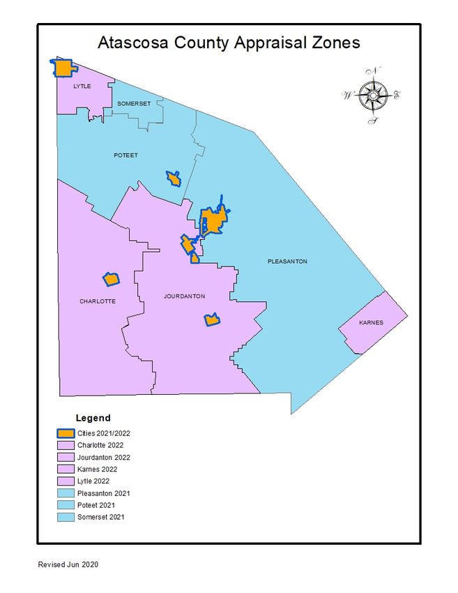
• Begin 2021 property appraisals for the Jourdanton 1, Pleasanton 2, Pleasanton 3, Poteet 1 and Poteet 2
zones (as defined by the Atascosa Appraisal Zone map).
• Begin 2021 Market analysis.
14
• Last day for Board of Directors to pass resolution to change number of directors, the method for
appointing or both and deliver resolution to each taxing entity.
September 2020
1
• Obtain permit information from entities for field review.
• Verify sales data.
• Continue market analysis.
• Continue field inspections.
10
• Special Call Board of Directors meeting.
15
• Last day for district Board of Directors to adopt 2021 budget. – Sect. 6.06(b)
• Last day for district Board of Directors to notify taxing entities in writing if a proposal to change a
finance method by taxing entities’ unanimous consent has been rejected.
• Last day for district Board of Directors to notify taxing entities in writing if a proposal to change the
number or method of selecting district directors is rejected by a voting taxing entity.
• Deadline for Reappraisal Plan adoption and submission to State Comptroller. - Sect. 6.05(i)
• Hold agricultural advisory board meeting.
• Mail farm and ranch surveys.
8October 2020
2
• Obtain permit information from Entities.
• Verify sales data.
• Continue market analysis.
• Continue field inspections.
16
• Notify required entities of Board of Directors members’ term expiration.
November 2020
2
• Obtain permit information from Entities.
• Continue market analysis.
• Continue field inspections.
• Verify sales data.
• Send wildlife management annual report requests.
19
• Scheduled Board of Directors meeting.
December 2020
1
• Obtain permit information from Entities.
• Conduct mail survey to verify homestead exemption eligibility.
• Continue market analysis.
• Verify sales data.
• Continue field inspections.
17
• Special Call Board of Directors meeting (if needed).
• Mail business personal property renditions.
January 2021
3
• Obtain permit information from Entities.
• Remove completion percentage adjustments.
• Mail exemption and special use applications.
• Mail residence homestead letters.
• Verify sales data.
• New Board of Directors members begin two year term.
• Continue market analysis.
• Continue field inspections.
21
• Scheduled Board of Directors meeting.
9February 2021
1
• Continue market analysis.
• Verify sales data.
• Continue field inspections.
March 2021
1
• Verify sales data.
• Hold agricultural advisory board meeting.
• Continue market analysis.
• Continue field inspections.
18
• Scheduled Board of Directors meeting.
30
• Finalize field inspections
• Finalize market analysis.
31
• Notify each taxing unit of the form in which the roll will be provided. – Sect 26.01(a)
April 2021
2
• Mail notice of appraised value to all property owners, or as soon thereafter as practicable.
• Publish protest procedures.
16
• Deadline for personal property renditions.
May 2021
3
• Publication of taxpayer protest procedures in local newspapers.
• Deadline for submission of preliminary values to ISDs. – Sect 26.01(e)
• Deadline for exemptions and special use applications.
15
• Submit appraisal records to the Appraisal Review Board. – Sect. 25.22
• Last day to mail notices of appraised value, denial of exemptions and denial of special use appraisal.
20
• Scheduled Board of Directors meeting
• Send proposed 2022 budget to Entities.
June 2021
15
• Last day to submit recommended 2022 budget to Board of Directors and taxing Entities. – Sect. 6.06(a)
10July 2021
22
• Submit appraisal roll to Appraisal Review Board for approval.
• Last day for ARB to approve records. – Sect. 41.12
• Scheduled Board of Directors meeting, public hearing on budget and budget adoption.
25
• Certify appraisal roll. – Sect. 26.01(a)
August 2021
2
• Begin 2022 property appraisals for the properties in Charlotte, Jourdanton 2, Karnes, Lytle, Pleasanton 1
and Pleasanton 4 zones (as defined by the Atascosa Appraisal Zone map).
• Begin 2022 Market analysis.
• Last day for property owners to apply for September 1 inventory appraisal for 2022.
19
• Last day for Board of Directors to pass resolution to change number of directors, the method for
appointing or both and deliver resolution to each taxing entity.
September 2021
1
• Obtain permit information from Entities.
• Verify sales data.
• Continue market analysis.
• Continue field inspections.
16
• Last day for district Board of Directors to adopt 2022 budget. – Sect 6.06(b)
• Last day for district Board of Directors to notify taxing entities in writing if a proposal to change a
finance method by taxing entities’ unanimous consent has been rejected.
• Last day for district Board of Directors to notify taxing entities in writing if a proposal to change the
number or method of selecting district directors is rejected by a voting taxing entity.
• Hold agricultural advisory board meeting.
• Mail farm and ranch surveys.
October 2021
1
• Obtain permit information from Entities.
• Verify sales data.
• Continue market analysis.
• Continue field inspections.
13
• Notify required entities of Board of Directors members’ term expiration.
11November 2021
1
• Obtain permit information from Entities.
• Continue market analysis.
• Verify sales data.
• Continue field inspections.
18
• Scheduled Board of Directors meeting.
December 2021
1
• Obtain permit information from Entities.
• Conduct mail survey to verify homestead exemption eligibility.
• Verify sales data.
• Continue market analysis.
• Continue field inspections.
23
• Special Call Board of Directors meeting (if needed).
January 2022
3
• Obtain permit information from Entities.
• Remove completion percentage adjustments.
• Mail exemption and special use applications.
• Send wildlife management annual report requests.
• Mail business personal property renditions.
• Mail residence homestead letters.
• Verify sales data.
• Continue market analysis.
• New Board of Directors members begin two year term.
• Continue field inspections.
20
• Scheduled Board of Directors meeting.
February 2022
1
• Continue market analysis.
• Verify sales data.
• Continue field inspections.
March 2022
1
• Verify sales data.
• Continue market analysis.
• Continue field checks.
12March 2022
1
• Hold agricultural advisory board meeting.
17
• Scheduled Board of Directors meeting.
30
• Finalize market analysis
• Finalize field inspections.
31
• Notify each taxing unit of the form in which the roll will be provided. – Sect 26.01(a)
April 2022
1
• Mail notice of appraised value to all property owners, or as soon thereafter as practicable.
• Publish protest procedures.
15
• Deadline for personal property renditions.
29
• Deadline for submission of preliminary values to ISDs. – Sect 26.01(e)
• Deadline for exemptions and special use applications.
•
May 2022
2
• Publication of taxpayer protest procedures in local newspapers.
16
• Submit appraisal records to the Appraisal Review Board. – Sect 25.22
• Last day to mail notices of appraised value, denial of exemptions and denial of special use appraisal.
19
• Scheduled Board of Directors meeting
• Send proposed budget to entities.
June 2022
13
• Last day to submit recommended 2023 budget to Board of Directors and taxing entities. – Sect 6.06(a)
July 2022
21
• Submit proposed Reappraisal Plan to Board of Directors.
• Last day for ARB to approve records. – Sect. 41.12
13July 2022
• Certify Appraisal Roll. – Sect. 26.01(a)
29
• Last day for property owners to apply for September 1 inventory appraisal for 2023.
August 2022
1
• Begin 2023 property appraisals for the properties in Charlotte, Jourdanton 2, Karnes, Lytle, Pleasanton 1
and Pleasanton 4 zones (as defined by the Atascosa Appraisal Zone map).
• Begin 2023 Market analysis.
15.
• Last day for Board of Directors to pass resolution to change number of directors, the method for
appointing or both and deliver resolution to each taxing entity.
September 2022
2
• Obtain permit information from entities for field review.
• Verify sales data.
• Continue market analysis.
• Continue field inspections.
8
• Special Call Board of Directors meeting (if needed).
14
• Last day for district Board of Directors to adopt 2023 budget. – Sect. 6.06(b)
• Last day for district Board of Directors to notify taxing entities in writing if a proposal to change a
finance method by taxing entities’ unanimous consent has been rejected.
• Last day for district Board of Directors to notify taxing entities in writing if a proposal to change the
number or method of selecting district directors is rejected by a voting taxing entity.
• Deadline for Reappraisal Plan adoption and submission to State Comptroller. - Sect. 6.05(i)
• Hold agricultural advisory board meeting.
• Mail farm and ranch surveys.
1415
16
ELEMENTS OF REAPPRAISAL

Performance Analysis

Certified values from the previous Tax Year are analyzed with ratio studies to determine appraisal accuracy and
appraisal uniformity by market area within property reporting categories. Ratio studies are conducted in
compliance with current Standard on Ratio Studies of the International Association of Assessing Officers
(IAAO, January 2010).

Reappraisal Decision

In some areas, statutes or administrative rules sometimes impose reappraisal requirements. A district may use a
cyclical schedule to review and revalue property each year or revalue all properties in mass at periodic
intervals; say every other year or every third year. Other reasons may be due to a ratio study or other external
factors. Reappraisals require careful planning and commitment of major resources.

Analysis of Available Resources

Staffing and budget requirements for Tax Year 2021 are detailed in the 2021 budget as adopted by the board of
directors. Staffing requirements have been identified and will be allocated accordingly to meet mandatory
suspense dates. Requirements for the 2022 Tax Year will be detailed in the 2022 budget, as adopted by the
board of directors no later than September 15, 2020.

Planning and Organization

Considered the most important aspect of reappraisal, defines goals and completion dates. All key events and
suspense dates are published in the District’s Tax Year calendar. The calendar is part of the reappraisal plan
and is adopted by the board of directors and published in two-year increments.

System Development

Custom forms and procedures for collecting and processing property characteristics, sales and income data are
in place and are reviewed annually.

Pilot Study

Pilot studies are utilized to test new or existing procedures or valuation modifications in a limited area (a
sample of properties) of the District and are also considered whenever substantial changes are made. These
studies, which are inclusive of ratio studies, reveal whether a proposed change is producing accurate and
reliable values or whether procedural modifications are required. The appraiser implements this methodology
when developing the cost approach and income approach models. All ratio studies are conducted in accordance
with IAAO and USPAP standards.

Data Collection

Collection of all available data using established procedures and forms. Field checks collect data on new
construction, demolition and remodeling while office data collection relies on sales data from available sources
and sales verification letters sent to buyers and sellers.

                                                      17
Production of Values
Values are produced using market analysis, development of schedules for residential and commercial properties
and calibration of the schedules using sales data. The schedules are then used to set preliminary value of
properties.
Preparation of the Assessment Roll
Final values are listed on the roll and notices mailed. Informal and formal appeals are conducted and the roll is
certified.
Final Performance Analysis
A final ratio study is performed to measure and evaluate the accuracy of the new values.
Data Maintenance
New Construction
New construction is identified by building permits, septic inspections, mechanics liens, monthly manufactured
home report and new subdivision plats.
Periodic Inspection
Every property is re-inspected at least once every three years.
Value Updates
Adjustments that are applied annually to properties between reappraisals are based on ratio studies or other
market analysis.
18CURRENT RESOURCES
Personnel Resources
The Office of the Chief Appraiser is responsible for the oversight of all operations of the appraisal district
including the overall planning, organizing, staffing, coordinating, and controlling of district operations. In
addition, the Chief Appraiser serves as the head of the administration department planning, organizing,
directing and controlling the business support functions that relate to human resources, budget, finance records
management, purchasing, fixed assets, facilities and postal property accounts. The property types appraised
include agricultural, commercial, residential and business personal.
The district's appraisers are subject to the provisions of the Property Taxation Professional Certification Act and
must be duly registered with the Texas Department of Licensing and Regulation (TDLR).
The appraisal district staff consists of 15 full time employees and a contract appraisal firm with the following
classifications:
1 - Chief Appraiser
1 – Assistant Chief Appraiser
5 - Staff Appraisers
1 - Bookkeeper/Administrative Assistant
1 - Deeds Supervisor
1 - Deeds Clerk
1 - Mapper
1 - Computer Systems Analyst/ARB Coordinator
1 – Exemptions Technician
2 – Transactions Clerks
1 – Contract Appraisal Firm
Staff Education and Training
All personnel that are performing appraisal work are registered with the Texas Department of Licensing and
Regulation and are required to take appraisal courses to achieve the status of Registered Professional Appraiser
within five years of employment as an appraiser. After they are awarded their license, they must receive 30
hours of continuing education in the 24-month period before the expiration of the registration. This will
include; 2 hours in professional ethics, the approved State laws and rules update course, and 3.5 hours of
USPAP training. Failure to meet these standards results in the termination of the employee or termination of
the contract for contracted personnel.
Data
The District is responsible for establishing and maintaining approximately 38,240 real and personal property
accounts and 28,124 mineral property accounts covering 1,232 square miles within Atascosa County Appraisal
District. This data includes property characteristic, ownership and exemption information. Property
characteristic data on new construction is updated through an annual field effort; existing property data is
maintained through a field review that is prioritized. Sales are routinely validated during a separate field effort.
General trends in employment, interest rates, new construction trends, and cost and market data are acquired
through various sources, including internally generated questionnaires to buyers, interviews with real estate
professionals and contractors.
19The District uses a geographic information system (GIS) that maintains cadastral maps and various layers of
data, ownership and aerial photography.
Atascosa Central Appraisal District (ACAD) currently maintains a Geographic Information System (GIS)
database using ESRI ArcGIS 10.7.0 software. The GIS database is made up of several layers and datasets that
cover a given map extent (Atascosa County). The spatial relationships between these layers are derived through
their common geographic location. Defining and describing these real-world locations requires a framework or
global coordinate system. A geographic coordinate system is used to assign geographic locations to objects.
Atascosa Central Appraisal District GIS database uses the Projected Coordinate System “NAD 1983 State Plane
Texas South Central FIPS_4204_Feet” to assign locations to the datasets and layers.
ACAD’s GIS system has two parts, aerial photos (Ortho tiles) and geographic datasets.
Ortho Tiles
The ortho tiles or raster datasets are the largest files. The Raster datasets consist of TIF, AUX, and TFW files.
Each ortho tile is 12000 x 8000 feet section of the county or a specific city and can be layered with other
datasets. There are separate ortho tiles for each city and the county (rural areas).
Geographic Datasets
The geographic datasets are made up of three dataset types. These are Feature Classes, Raster Datasets, and
Associated Attribute Tables. Feature classes contain vector-based features (sets of points, lines, and polygons),
raster datasets contain digital imagery, and associated attribute tables contain descriptive information about the
geographic objects (parcels) and features.
There are separate datasets for roads, water (rivers, creeks, drainage, etc), buildings, utility, cultural (fences…),
railroad, topography lines, vegetation, school districts, county border, sheet annotation, sub-sheet annotation,
and control points. The data sets are divided into two categories, city and county. All the data is contained in
MS Access database and MS Excel files.
The GIS database also contains a parcel map of Atascosa County. This parcel map layer contains the
Coordinate Geometry (COGO) and survey information, parcel polygons, descriptive attributes (Parcel ID, GEO
Reference Number, size in acres…), and feature classes for the parcels. This information is also made up of MS
Access database and MS Excel files.
The products produced from the mapping system are for informational purposes and may not have been
prepared for or be suitable for legal, engineering, or surveying purposes. It does not represent an on-the-
ground survey and represents only the approximate relative location of property boundaries.
Information System
The Atascosa Appraisal District houses a server containing the appraisal records for the district. This
information is accessed by multiple PC's in the appraisal office. The PACS software application is utilized and
can be accessed by True Automation via the internet for software updates and modifications.
20Shared Appraisal District Boundaries
The State of Texas HB 1010 amended the Texas Property Tax Code identifying an Appraisal District’s
boundaries as the county’s boundaries. As stated in Section 6.02 (a), “The appraisal district’s boundaries are
the same as the county’s boundaries.”
Independent Performance Test
According to Section 403.302 (a) DETERMINATION OF SCHOOL DISTRISCT PROPERTY VALUES, of
the Texas Government Code;
(a) The comptroller shall conduct a study using comparable sales and generally accepted auditing and
sampling techniques to determine the total taxable value of all property in each school district. The study
shall determine the taxable value of all property and of each category of property in the district and the
productivity value of all land that qualifies for appraisal on the basis of its productive capacity and for
which the owner has applied for and received a productivity appraisal.
This study is performed every two years, if the school district’s value is considered to be valid. If the school
district’s value is considered invalid, a PVS will be done annually. The code also requires the Comptroller to:
test the validity of school district taxable values in each school district and presume the appraisal roll values are
correct when values are valid; and, determine the level and uniformity of property tax appraisal in each school
district. The methodology used in the property value study includes stratified samples to improve sample
representativeness and techniques or procedures of measuring uniformity, this study utilizes statistical analysis
of sold properties (sale ratio studies) and appraisals of unsold properties (appraisal ratio studies) as a basis for
assessment ratio reporting.
For appraisal districts, the reported measures include median level of appraisal, coefficient of dispersion
(COD), the percentage of properties within 10% of the median, the percentage of properties within 25% of the
median, and price-related differential (PRD) for properties overall and by state category (i.e., categories
A,B,C,D and F1 are directly applicable to real property). Code also requires the Comptroller to: publish a
report of the findings of the study, including the median levels of appraisal and the coefficient of dispersion for
each category of property, and any other standard statistical measures deemed appropriate by the comptroller.
There are seven independent school districts in Atascosa CAD for which appraisal rolls are annually developed.
The preliminary results of the PVS are released in January in the year following the year of appraisement. The
final results of their study are certified to the Education Commissioner of the Texas Education Agency (TEA)
in the following July of each year for the year of appraisement. This outside (third party) ratio study provides
additional assistance to the ACAD in determining areas of market activity or changing market conditions. The
PVS for Atascosa CAD is currently conducted by the Comptroller in odd number years.
Chapter 5 for the TPTC also states that the Comptroller shall conduct a ratio study every two years, as outlined
by Section 403.302(a) of the Texas Government Code and publish the findings to all members of the legislature
and to all appraisal districts.
Also required by Chapter 5 of the TPTC is that the Comptroller’s Property Tax Division shall review the
CAD’s governance, taxpayer assistance, operating standards, appraisal procedures and appraisal methodology
at least every two years. This is known as the Methods and Assistance Program (MAP) review. Once the study
is completed, the comptroller will notify, in writing, the appraisal district concerning its performance in the
review.
The MAP review is currently conducted by the Comptroller in even numbered years.
21APPRAISAL ACTIVITIES
The appraisal staff is responsible for collecting and maintaining property characteristic data for classification,
valuation, and other purposes (Appraisers Handbook). Accurate valuation of real and personal property by any
method requires a physical description of personal property, and land and building characteristics. This
appraisal activity is responsible for administering, planning and coordinating all activities involving data
collection and maintenance of all commercial, residential and personal properties, which are located within the
boundaries of Atascosa CAD. The data collection effort involves the field inspection of real and personal
property accounts, as well as data entry of all data collected into the existing information system. The goal is to
field inspect residential and commercial properties within the boundaries of Atascosa CAD every three years,
and personal properties every year. Meeting this goal is dependent on budgetary constraints.
Data Collection/Validation
Data collection of real property involves maintaining data characteristics of the property on CAMA. The
information contained in CAMA includes site characteristics, such as land size and topography, and
improvement data, such as square foot of living area, quality of construction and condition. Field appraisers use
listing manuals that establish uniform procedures for the correct listing of real property. All properties are
coded according to these manuals and the approaches to value are structured and calibrated based on this coding
system. The field appraisers use these manuals during their initial training and as a guide in the field inspection
of properties. Data collection for personal property involves maintaining a folder containing all renditions,
recent valuations and correspondence. The types of information contained in these folders are broken down into
inventory, furniture, fixtures and equipment, machinery and vehicles. Each account is identified with the
appropriate SIC code. The field appraisers conducting on-site inspections use the personal property manual
during their initial training and as a guide to correctly list all personal property that is taxable.
Field data collection requires organization, planning and supervision of the field effort. Data collection
procedures have been established for residential, commercial and personal property. Appraisers conduct field
inspections and record information either on an iPad, a property record card or a personal property data sheet.
The quality of the data used is extremely important in establishing accurate values of taxable property. While
production standards are established and upheld for the various field activities, quality of data is emphasized as
the goal and responsibility of each appraiser. The Chief Appraiser is charged with the responsibility of ensuring
that appraisers follow listing procedures, identify training issues and provide uniform training throughout the
field appraisal staff.
Sources of Data
The sources of data collection are through the new construction field effort, data review field effort, hearings,
sales validation, 911 new addresses, new electrical hook-ups, manufactured home movement reports,
commercial sales verification, newspapers and publications, and property owner correspondence. A principal
source of data comes from building permits received from taxing jurisdictions that require property owners to
take out a building permit. Paper permits are received and matched manually with the property's tax account
number for fieldwork.
Data review of entire neighborhoods is generally a good source for data collection. Appraisers research entire
neighborhoods to verify the accuracy of our data and identify properties that have to be reviewed. The sales
22validation effort in real property pertains to the collection of data of properties that have sold. The sales
validation effort involves on-site inspection by field appraisers to verify the accuracy of the property
characteristics data and confirmation of the sales price. Property owners are one of the best sources for
identifying incorrect data that generates a field check.
In terms of sales data, Atascosa CAD receives a copy of the deeds recorded in Atascosa County. The deeds
involving a change in ownership are entered into the sales information system and researched in an attempt to
obtain the pertinent sale information. Other sources of sales data include the hearings process, realtors and
appraisers.
For those properties involved in a transfer of commercial ownership, a sale file is produced which begins the
research and verification process. The initial step in sales verification involves a computer-generated
questionnaire, which is mailed to the new owner. If a questionnaire is answered and returned, the document
responses are recorded into the computerized sales database system. Closing statements are often provided
during the hearings process. The actual closing statement is the most reliable and preferred method of sales
verification.
Data Quality Control
In accordance with IAAO Standard on Mass Appraisal 3.3.2.5, it is a requirement of the appraisal district to
have accurate records of all properties within its boundaries. In order for the district to do this it must employ a
process where quality of work and services can be identified and evaluated. The results must show certain
minimum levels of quality are being attained, identify those areas that do not meet the district’s specified
standards and lead to the correction of any issues identified.
Quality control as it relates to appraisers should be utilized as a learning tool by providing the opportunity for
constructive feedback over the course of their development. An appraiser’s work should be monitored for
understanding of the process, uniformity of procedures followed, and accuracy of work turned in. Quality
control will help identify appraiser’s having difficulty with appraisal concepts, technical aspects of data
collection, or mass appraisal techniques which may lead to retraining. End results of quality control should
promote appraiser development and produce a more accurate final product.
Supervisors will provide frontline quality control and will be held responsible for the quality of work done by
appraisers under their direct supervision. Quality control tasks should include going to the field with appraisers
to ensure correct procedures are being followed and to witness interaction with property owners, random field
check of work turned in and review of field data entered into PACS.
Quality control of the data entry is done to ensure that data entry of appraisers’ work has been entered into
PACS correctly.
Field Review
The date of last inspection and the appraiser responsible are listed on the CAMA record. If a property owner or
jurisdiction, dispute the District's record concerning this data during a hearing, via a telephone call or
correspondence received, CAMA may be altered based on the evidence provided. Typically, a field inspection
is requested to verify this evidence for the current year's valuation or for the next year's valuation. Every year a
field review of certain areas or neighborhoods in the jurisdiction is done during the field effort.
23Performance Test
The Chief Appraiser and the Appraisers are responsible for conducting ratio studies and comparative analysis.
Field appraisers, in many cases may conduct field inspections to ensure the ratios produced are accurate and the
appraised values utilized are based on accurate property data characteristics.
RESIDENTIAL VALUATION PROCESS
The appraisers are responsible for developing equal and uniform market values for residential properties, both
vacant and improved. There are 32,030 real property, and 3,722 Mobile Home property accounts in the
Atascosa CAD.
Valuation Approach
Area Analysis
Data on regional economic forces such as demographic patterns, regional locational factors, employment and
income patterns, general trends in real property prices and rents, interest rate trends, availability of vacant land,
and construction trends and costs are analyzed from private vendors and public sources and provide the field
appraiser a current economic outlook on the real estate market. Information is gained from real estate
publications and sources such as continuing education in the form of IAAO and TDLR classes and various
seminars.
Neighborhood and Market Analysis
Neighborhood analysis involves the examination of how physical, economic, governmental and social forces
and other influences affect property values. The effects of these forces are also used to identify, classify and
stratify comparable properties into smaller, manageable subsets of the universe of properties known as
neighborhoods. Residential valuation and neighborhood analysis is conducted on each of the political entities
known as Independent School Districts (ISD).
The first step in neighborhood analysis is the identification of a group of properties that share certain common
traits. A "neighborhood" for analysis purposes is defined as the largest geographic grouping of properties where
the property's physical, economic, governmental and social forces are generally similar and uniform.
Geographic stratification accommodates the local supply and demand factors that vary across a jurisdiction.
Once a neighborhood has been identified, the next step is to define its boundaries. This process is known as
"delineation". Some factors used in neighborhood delineation include location, sales price range, lot size, age of
dwelling, quality of construction and condition of dwellings, square footage of living area and story height.
Delineation can involve the physical drawing of neighborhood boundary lines on a map, but it can also involve
statistical separation or stratification based on attribute analysis. Part of neighborhood analysis is the
consideration of discernible patterns of growth that influence a neighborhood's individual market. Few
neighborhoods are fixed in character. Each neighborhood may be characterized as being in a stage of growth,
stability or decline. The growth period is a time of development and construction. As new neighborhoods in a
community are developed, they compete with existing neighborhoods. An added supply of new homes tends to
induce population shift from older homes to newer homes. In the period of stability, or equilibrium, the forces
of supply and demand are about equal. Generally, in the stage of equilibrium, older neighborhoods can be more
desirable due to their stability of residential character and proximity to the workplace and other community
facilities. The period of decline reflects diminishing demand of desirability. During decline, general property
24use may change from residential to a mix residential and commercial uses. Declining neighborhoods may also
experience renewal, reorganization, rebuilding or restoration, which promotes increased demand and economic
desirability.
Neighborhood identification and delineation is the cornerstone of the residential valuation system at the
District. All the residential analysis work done in association with the residential valuation process is
neighborhood specific. Neighborhoods are field inspected and delineated based on observable aspects of
homogeneity. In addition to physical inspections, aerial/ortho photography may also be used for inspection of
properties. This may include the results of any Pictometry Change Finder study. Neighborhood delineation is
periodically reviewed to determine if further neighborhood delineation is warranted. Sales ratio analysis,
discussed below, is performed on a neighborhood basis, by ISD.
Highest and Best Use Analysis
The highest and best use of property is the reasonable and probable use that supports the highest present value
as of the date of the appraisal. The highest and best use must be physically possible, legal, financially feasible,
and productive to its maximum. The highest and best use of residential property is normally its current use. This
is due in part to the fact that residential development, in many areas, through use of deed restrictions and
zoning, precludes other land uses. Residential valuation undertakes reassessment of highest and best use in
transition areas and areas of mixed residential and commercial use. In transition areas the market value of a
residence homestead shall be determined as a residence homestead, “The market value of a residence
homestead shall be determined solely on the basis of the property’s value as a residence homestead, regardless
of whether the residential use of the property by the owner is considered to be the highest and best use of the
property.”, as stated in the Texas Property Tax Code, 23.01(d). Once the conclusion is made that the highest
and best use remains residential, further highest and best use analysis is done to decide the type of residential
use on a neighborhood basis.
Valuation and Statistical Analysis
Cost Schedules
The cost approach to value is applied to all improved real property utilizing the comparative unit method. This
methodology involves the utilization of national cost data reporting services as well as actual cost information
on comparable properties whenever possible. Cost models are typically developed based on the Marshall Swift
Valuation Service. Cost models include the derivation of replacement cost new (RCN) of all improvements.
These include comparative base rates, per unit adjustments and lump sum adjustments. This approach also
employs the sales comparison approach in the valuation of the underlying land value. Location modifiers are
necessary to adjust cost data to reflect conditions in a specific market and changes in costs. Because a national
cost service is used as a basis for the cost models, locational modifiers are necessary to adjust these base costs
specifically for Atascosa County. Some of these modifiers are provided by the national cost services.
Sales Information
A sales file for the storage of "snapshot" sales data at the time of sale is maintained. Residential vacant land
sales and residential improved sales, along with commercial improved and vacant land sales are maintained in a
separates sales information system. Residential improved and vacant sales are collected from a variety of
sources, including: district questionnaires sent to buyer, field discovery, protest hearing, appraiser, builders and
realtors. School district or neighborhood sales reports are generated as an analysis tool for the appraiser in the
development of value estimates.
25Land Analysis
Residential land analysis is conducted by the appraisers. The appraisers develop a base lot, primary rate, and
assign each unique neighborhood to a land table. A computerized, land table, file stores the land information
required to consistently value individual parcels within neighborhoods. Specific land influences are used, where
necessary, to adjust parcels outside the neighborhood norm for such factors as view, shape, size and
topography, among others. The appraisers use abstraction and allocation methods to ensure that the land values
created best reflect the contributory market value of the land to the overall property value.
Statistical Analysis
The appraisers perform statistical analysis annually to evaluate whether values are equitable and consistent with
the market. Ratio studies are conducted on each ISD in the district to judge the two primary aspects of mass
appraisal accuracy, level and uniformity of value. The level of appraised values is determined by the weighted
mean for individual properties within a neighborhood, and a comparison of neighborhood weighted means
reflect the general level of appraised value.
Market data is reviewed annually through the sales ratio analysis process. The first phase involves
neighborhood ratio studies that compare the recent sales prices of neighborhood properties to the appraised
values of these sold properties. This set of ratio studies affords the appraiser an excellent means of judging the
present level of appraised value and uniformity of the sales. The appraiser, based on the sales ratio statistics and
designed parameters for valuation update, makes a preliminary decision as to whether the value level in a
neighborhood needs to be updated in an upcoming reappraisal, or whether the level of market value in a
neighborhood is at an acceptable level.
Market Adjustment
Neighborhood or market adjustment factors are developed from appraisal statistics provided from ratio studies
and are used to ensure that estimated values are consistent with the market. The district's primary approach to
the valuation of residential properties uses a hybrid cost sales comparison approach. This type of approach
accounts for neighborhood market influences.
The following equation denotes the hybrid model used:
MV= MA [LV + (RCN - D)]
Whereas, the market value (MV) equals the market adjustment (MA) factor times the land value (LV) plus the
replacement cost new (RCN) less depreciation (D). As the cost approach separately estimates both land and
building values and uses depreciated replacement costs, which reflect only the supply side of the market, it is
expected that adjustments to the cost values are needed to bring the level of appraisal to an acceptable standard;
however, the low market prices in some areas of the county preclude the adoption of current cost values.
Depreciation factors would be excessive given the condition of the structure. Market or location adjustments are
applied uniformly within neighborhoods to account for locational variances between market areas or across a
jurisdiction. If a neighborhood is to be updated, the appraiser uses a market ratio study that compares recent
sales prices of properties within a delineated neighborhood with properties' actual cost value. The calculated
ratio derived from the sum of the sold properties' cost value divided by the sum of the sales prices indicates the
neighborhood level of value based on the unadjusted cost value for the sold properties. This cost-to-sale ratio is
compared to the appraisal-to-sale ratio to determine the market factor needed to trend the values obtained
through the cost approach closer to the actual market evidenced by recent sales prices within a given
neighborhood. The sales used to determine the market adjustment factor will reflect the market influences and
26conditions only for the specified neighborhood, thus producing more representative and supportable values. The
market adjustment factor calculated for each update neighborhood is applied uniformly to all homogeneous
properties within a neighborhood. Once the market trend factors are applied, a second set of ratio studies is
generated that compares recent sale prices with the proposed appraised values for these sold properties. From
this set of ratio studies, the appraiser judges the appraisal level and uniformity in both update and non-update
neighborhoods, and finally, for the school district as a whole.
Individual Value and Review Procedures
Field Review
The appraiser identifies individual properties in critical need of field review through sales ratio analysis. Sold
properties with a high variance in sales ratios are field reviewed to check for accuracy of data characteristics.
Sales activity has also resulted in a field effort on the part of the appraisers to review and resolve sales outliers.
Additionally, the appraiser frequently field reviews subjective data items such as quality of construction,
condition, and physical, functional and economic obsolescence, factors contributing significantly to the market
value of the property. After preliminary estimates of value have been determined, the appraiser takes valuation
documents to the field to test the computer-assisted values against their appraisal judgment. During this review,
the appraiser is able to physically inspect both sold properties and unsold properties for comparability and
consistency of values. In addition to physical inspections, aerial/ortho photography may also be used for
inspection of properties. This may include the results of any Pictometry Change Finder study.
Office Review
Valuation reports comparing previous values against proposed and final values are generated for all residential
properties. The dollar amount and percentage of value difference are noted for each property within a delineated
neighborhood allowing the appraiser to identify, research, and resolve value anomalies before final appraised
values are released. Previous values resulting from a hearing protest are individually reviewed to determine if
the value remains appropriate for the current year. Aerial/ortho photography may also be used for office
reviews. This may include the results of any Pictometry Change Finder study.
Once the appraiser is satisfied with the level and uniformity of value for each neighborhood, the estimates of
value are sent out as appraisal notices.
Performance Tests
Sales Ratio Studies
The primary analytical tool used by the appraisers to measure and improve performance is the ratio study. The
district ensures that the appraised values it produces meet the standards of accuracy in several ways. Overall
sales ratios are generated for each ISD to allow the appraiser to review general market trends, and provide an
indication of market change over a specified period of time. The neighborhood descriptive statistics are
reviewed for each neighborhood being updated for the current tax year.
27TREATMENT OF RESIDENCE HOMESTEADS
Beginning in 1998, the State of Texas implemented a constitutional classification scheme concerning the
appraisal of residential property that receives a homestead exemption. Under the new law, beginning in the
second year a property receives a homestead exemption; increases in the value of that property are "capped."
The value for tax purposes (appraised value) of a qualified residence homestead will be the LESSER of
the market value; or
the preceding year's appraised value;
PLUS 10 percent for each year since the property was re-appraised;
PLUS the value of any improvements added since the last re-appraisal.
Values of capped properties must be recomputed annually. If a capped property sells, the cap automatically
expires as of January 1st of the following year. In that following year, that home is reappraised at its market
value to bring its appraisal into uniformity with other properties. An analogous provision applies to new homes.
While a developer owns them, unoccupied residences are appraised as part of an inventory using the district's
land value and the developer's construction costs as of the valuation date. However, in the year following the
sale, they are reappraised at market value.
AGRICULTURAL VALUATION PROCESS
Texas Constitution provides for the special valuation of "open space land devoted to farm or ranch purposes." In
other words, undeveloped non-agricultural land does not qualify.
This is a special valuation for land that is devoted to agricultural production. Agricultural or productivity value is
based on the land's capacity to produce crops or livestock instead of its value on the real estate market. Although
this lower value reduces the taxes on the property, a "rollback" of these taxes will take place when the land stops
being used for an agricultural purpose. The rollback recaptures, with interest, the taxes saved for the three (3)
years preceding the change in use. Because of the penalty, this valuation is of questionable benefit if your usage is
short term or if you have plans to develop the tract within the next six (6) years.
Approach to Values
Atascosa Appraisal District has implemented the standard Cash Lease Method to determine the net to land
estimates for the 2019 1-D-1 productivity values by land class. Only typical cash lease information is used to
determine these estimates. The types of lease agreements used are; hunting leases and land lease agreements.
The district contracts with Perdue Brandon Fielder Collins & Mott LLP to analyze the lease data and update
schedules annually.
Wildlife Management
Texas also has a Wildlife Management program. Under this program there are two main qualifications; one that
the land must already have an agricultural exemption and the other is that the owner must use the land to
propagate a sustaining breeding, migrating or wintering population of indigenous wild animals. A wildlife
management plan must be filed with the district to obtain a wildlife management special use evaluation. The
district also requires that an annual report be submitted on all parcels with a wildlife management special use
evaluation. Forms are available at the district office or on line at the Texas Parks and Wildlife Office web site
www.tpwd.state.tx.us
28You can also read