Automating the Assessment of Municipality-Owned Real Estate Assets Using GIS - Alejandra Coronado, Brittany Burson - Esri
←
→
Page content transcription
If your browser does not render page correctly, please read the page content below

Automating the Assessment of
Municipality-Owned Real Estate Assets
Using GIS
Alejandra Coronado, Brittany Burson
Introduction

    Alejandra Coronado
    Before joining the City as a GIS Analyst, Alejandra was a Research Assistant
    while completing her degree in Geographic Information Science at San Diego
    State University.
    Brittany Burson
    Before joining the City as a GIS Analyst, Brittany worked for a public safety
    vendor and the San Diego County Assessor. She is an alumni of the UC Berkeley
    Geography department.
•   8th Largest City in the United States
•   Industries – Military, Tourism, Biotech,
    Research, Cyber Security, Craft Beer
•   Population 1.400,000
•   325 square miles
•   11,500 Employees
•   $3.8 Billion Annual Budget
•   400 Facilities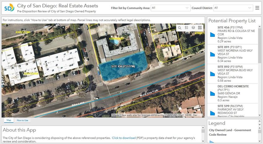
Background
Dispositions Process

Background
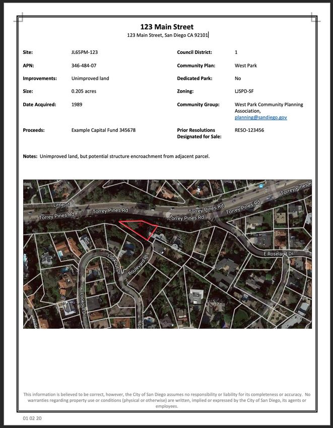
• City owns more than 1,600 properties that total estimated 123,000 acres
• Majority of City-owned properties are in use and/or being held for essential City
services such as existing police stations, fire stations, libraries, maintenance yards,
airports, Petco Park, dedicated parkland, and long-term leases to third parties
• Periodic review of vacant properties for possible sale or hold
- Properties are cleared for sale first with City departments
- If not required by City departments, properties are designated “Surplus” by City Council
Background

 •   Project with our Real Estate Assets Department, Dispositions Division
 •   Primarily responsible for processing disposition of improved or vacant surplus
     properties and other tasks to support the various real estate requirements of other
     City departments
 •   When a property is suitable, seeks opportunities for affordable housing on City-
     owned surplus property by offering surplus property first to affordable housing
     sponsors during the clearance process
Legacy Process
Background – cont.

 Department responses may indicate:
 •   If the properties should be retained for municipal use
 •   Description of any easements, restrictions or requirements that may affect or impact
     the disposition or possible future development of the property
 •   If a department wants to retain a property, and if so, provides concept plans and
     timeline for the property
Opportunities

 •   Manual and labor-intensive workflow
 •   Lack of transparency between departments
 •   Information only reaching the hands of a few people
 •   Lack of easily retrievable historical review history
 •   Missed opportunity for added spatial context and automated return of information
Streamlined Process
New Workflows
Streamlined Process
• Esri Enterprise Agreement
• Portal Access
- Use of Portal for security + self-sign on via Okta, allows access to all City staff
• ArcGIS Solutions “Crowdsource Polling” app
- User-friendly way to provide responses (add comments + attachments)
- Transparency across departments
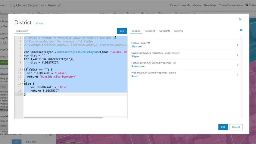
• Arcade expressions
- FeatureSetBy() function
• ArcGIS Dashboards
- To communicate results to outside agencies; redirect URLDemo
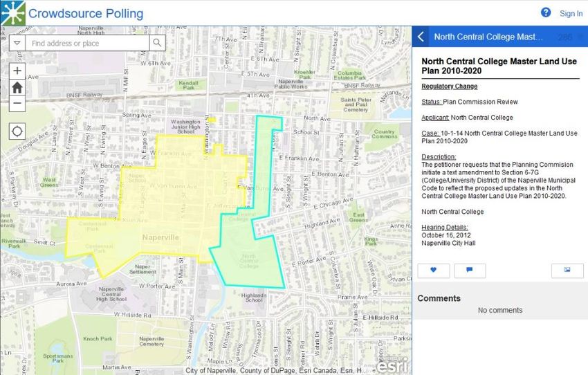
ArcGIS Solutions/Configurable Apps

 •   Crowdsource Polling app built for collecting public
     feedback
 •   Contains user friendly interface for adding
     comments, “Likes”, images and attachments
 •   Comments and attachments are stored in a related
     table
 •   Focused list guides the user to
     properties undergoing review
Arcade Sample
• Use of FeatureSetByName
Arcade expressions to gather
and list information about
intersecting features, such as
APN
• Use of primary source rest
services ensures most up to
date information
• Single click returns information
for several associated featuresDemo
ArcGIS Dashboards | Communicating results

 •   In progress: Dashboard to
     communicate updates to
     outside government agencies
 •   Use of Views to filter publicly
     accessible information
 •   Ability to show relevant
     layers, including data
     available in the “Statewide
     Affordable
     Housing Opportunities Sites”
     web app

                                            Same layers as Statewide app
Conclusions New Tech for Old Workflows
Conclusion

 •   GIS allowed us to centralize information into an interactive web-
     based app, accessible to our entire City via Intranet
 •   Spatial context through interactive map
 •   Brought transparency to review process and access to all City staff
 •   Reposition of responses in single location, rather than Outlook
     folders in a single user’s inbox
 •   Sparked enthusiasm and vision among users… “new hotness”
Improvement Opportunities
• Extract, Transfer, and Load (ETL) to transfer comments and
attachments from feature class into Real Estate Assets vendor
database
- Data Interoperability extension
• Dynamic/on-the-fly arcade expressions
- Ability to export to CSV file
• Printing pop up information
• Expanded functionality into Review app; such as additional layersBroader Use Cases
• Example of repurposing an ArcGIS Solution to our needs (internal)
• Most GIS in Real Estate industry surrounds commercial real estate;
lack of groundwork in other areas
• Potential to cooperate with State systems (e.g. Affordable Housing)Contact Information
Alejandra Coronado
City of San Diego, Department of Information
Technology
AlejandraC@sandiego.gov
Brittany Burson
City of San Diego, Department of Information
Technology
BBurson@sandiego.govYou can also read