Autonomous cars navigation on roads opened to public traffic: How can infrastructure-based systems help? - PFIA 2018
←
→
Page content transcription
If your browser does not render page correctly, please read the page content below
Autonomous cars navigation on roads
      opened to public traffic:
   How can infrastructure-based
          systems help?

                    Philippe Bonnifait
                          Professor at the
   Université de Technologie de Compiègne, Sorbonne Universités
                  Heudiasyc UMR 7253 CNRS, rance

                         ROB & IA 2018
                    Nancy, France, July 5, 2018
                            ROB & IA 2018
                                                                  1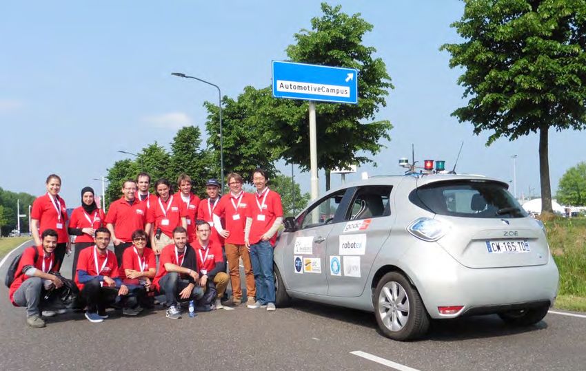
Autonomous cars navigation

Cars don’t drive in opened spaces

                The navigation space is constrained
                and there are interactions between cars.

                             ROB & IA 2018
                                                           2
Main question addressed in this talk
How can a car see far enough with a reasonable set of
embedded sensors?

                          ROB & IA 2018
                                                        3
Outline
1. Level of autonomy of autonomous vehicles
2. Key elements for cooperative autonomous
   navigation
3. Cooperative navigation example: vehicle2vehicle
   communication
 1.   Intersection crossing
 2.   Platooning
4. Infrastructure‐aided Systems
 1.   Lane Merging
 2.   Roundabout crossing
5. Conclusion and perspectives

                              ROB & IA 2018
                                                     4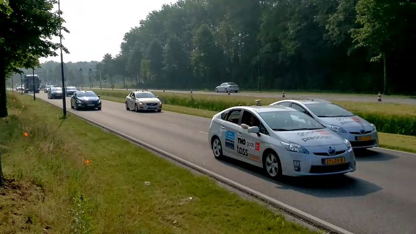
Level of autonomy of
autonomous vehicles

         Part 1

        ROB & IA 2018
                        5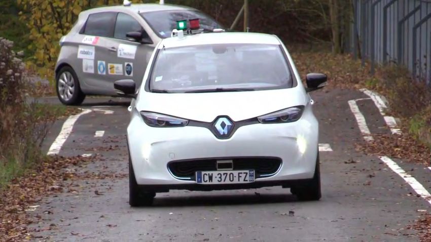
Autonomous Vehicles: Trends
Driverless vehicles Autonomous cars
o New Mobility Services o Traditional customers
o Shuttles and Robot taxis o Valet vehicle
o Traffic Jam Assist
automotive
Converge
robotics
ROB & IA 2018
6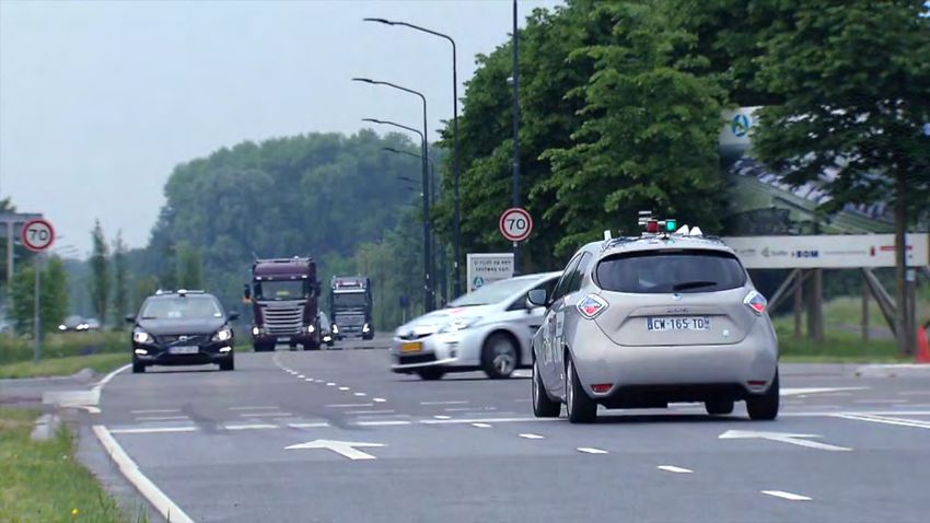
Robot vehicle
Ability to function independently of a human operator in any
context
Operational autonomy
― Feedback mechanisms to control behavior to follow a predefined
 trajectory, while rejecting disturbances
― No need for user monitoring
Decisional autonomy
― The machine has the ability to understand and take safe decisions despite
 the uncertainties of perception and localization as well as incomplete
 information about the environment

                                 ROB & IA 2018
                                                                              7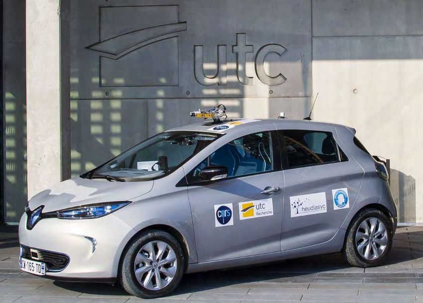
The three roboticist axes
                Autonomy ability
       Independence with respect to human

                                      Complexity of the
                                       mission or task
Complexity of the environment
  and of the navigation area

                      ROB & IA 2018
                                                          8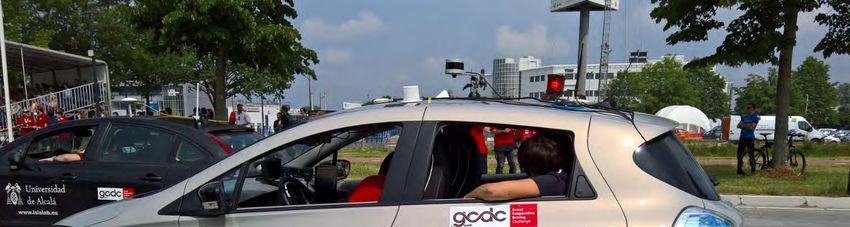
Example of autonomous car: Valet Vehicle (PAMU Renault)

                       ROB & IA 2018
                                                      9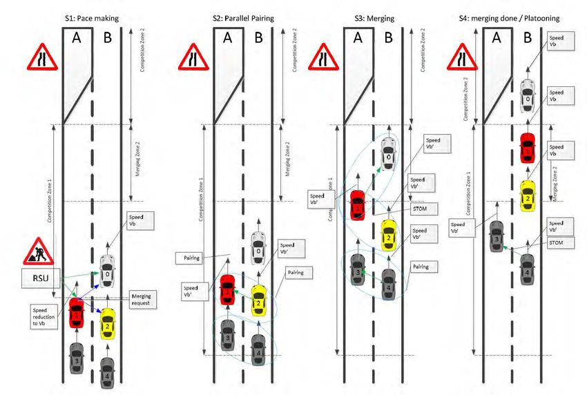
The valet vehicle of the roboticist axes
                Autonomy ability
       Independence with respect to human

                                 Valet Vehicle

                                      Complexity of the
                                       mission or task
Complexity of the environment
  and of the navigation area

                      ROB & IA 2018
                                                          10
Cooperation as a mean to increase abilities of
autonomous cars
Autonomy ability
I want my car to have a
high level of autonomy
Complexity of the
mission or task
Complexity of the environment
and of the navigation area
ROB & IA 2018
11Key elements for
cooperative
autonomous
navigation
Part 2
ROB & IA 2018
12Sources of information for autonomous
navigation
GNSS receiver
Exteroceptive
sensors
Digital maps
Proprioceptive sensors
ROB & IA 2018
13Localization and perception
Localization system Je sui la !
― allows the vehicle to position itself
spatially, absolutely or relatively, in its
evolution environment
Perception system
― equips the vehicle with understanding
and prediction capabilities of its
immediate environment. From the
sources of information available, the
vehicle builds a representation of the
environment that allows it to navigate
ROB & IA 2018
14Localization and perception
World Model
Real world
ROB & IA 2018
15Wireless communication for cooperative
autonomous navigation
GNSS receiver
Wireless
communication
Exteroceptive
means
sensors
Digital maps
Proprioceptive sensors
ROB & IA 2018
16Wireless Networks for data exchange
Vehicular ad hoc networks (VANETs) allow an augmented
perception of the dynamic environment by using wireless
communications:
― Vehicle‐to‐Vehicle (V2V)
― Infrastructure to Vehicle (I2V)
Some typical messages (ETSI standard)
― CAM (Cooperative Awareness Message)
― DENM (Distributed Environment Notification Message)
― CPS (Collective Perception Service ‐ ETSI TR 103 562 under preparation)
Features
― short range radio technologies (Wifi mode), 5.9 GHz band (802.11p)
― Broadcast frequency: 1‐10 Hz
ROB & IA 2018
17 17CAM Message (V2V)
Vehicle information
― ID
― Vehicle type (car, truck, etc.)
― Vehicle role (emergency, roadwork)
― Vehicle size (length and width)
Time Stamp
― UTC time (in ms, ~1 minute ambiguity)
Pose
― Position (geo) + 95% confidence bound
― Heading
Kinematics
― Speed, drive direction, yaw rate
― Acceleration
ROB & IA 2018
18 18DENM Message (I2V)
Sent by Road Side Units (RSU)
Data :
― Station type
― Time Stamp
― Event type
‒ Roadworks,
‒ Stationary vehicle,
‒ Emergency vehicle approaching,
‒ Dangerous Situation, etc.
― Lane position
― Lane is closed or not
ROB & IA 2018
19CPS Message (I2V)
Can be emitted by the infrastructure or the vehicles.
Information:
― List of detected objects
― Position, speed, acceleration
― ID and type of the sensor which provided the measurement data
ROB & IA 2018
20Typical processing loop
Sensors, Localization and
perception Decision,
maps and Acquisition planning and actions
wireless (world modeling control
information and understanding)
Wireless
communication
Localization and perception
information
ROB & IA 2018
21Cooperative
navigation example:
intersection crossing
with V2V data
Exchange
Part 3
ROB & IA 2018
22Grand Cooperative Driving Challenges
GCDC 2011
― A270 highway between Helmond and Eindhoven.
― Cooperative platooning (sensor based‐control
with speed and acceleration exchange)
― 9 teams (with cars and trucks)
GCDC 2016
― Same place
― May 28‐29, 2016
― Autonomous driving with interactions with vehicles and infrastructure
― Three different traffic scenarios
― 10 European teams.
Main Challenge
― Cooperation between heterogeneous systems implementing different
algorithms
ROB & IA 2018
23Heudiasyc team
Team Leader:
Philippe XU
People involved
― 5 Profs and Researchers
― 3 Engineers
― 2 Phd students
― 2 interns
― 12 Master students
ROB & IA 2018
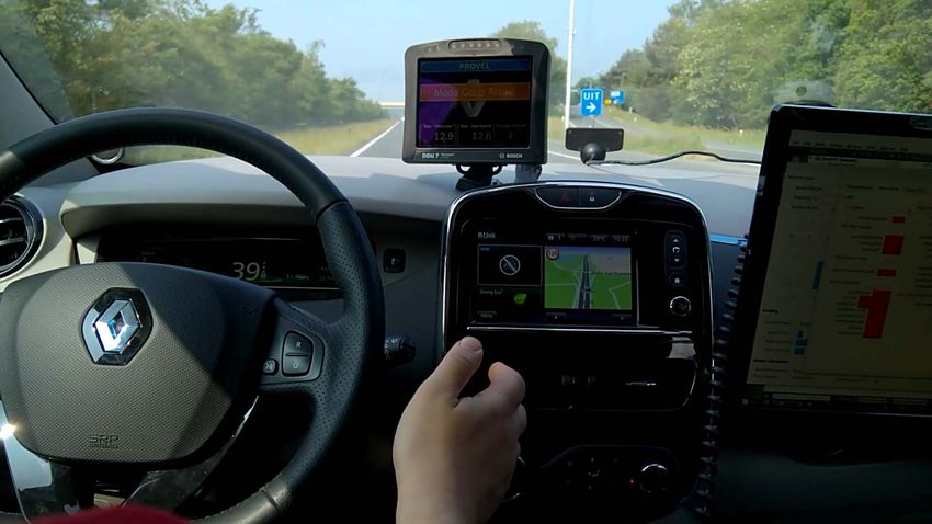
24Experimental vehicle
Fully electric car (Renault Zoé)
Maximum speed of 50 km/h while driving autonomously
ROB & IA 2018
25Snapshot of the GCDC 2016
ROB & IA 2018
26Inter-distance for platooning
In straight road, inter‐distance is easy to measure (e.g. Lidar)
In curved road, compute
the inter‐distance along
the map by using
positions exchanged by
wireless communication
ROB & IA 2018
27Cooperative merging using virtual platooning
ROB & IA 2018
28The virtual platooning concept
Every vehicle
― Computes its distance to the crossing point
― Such that the others can localize it on their own path
ROB & IA 2018
29The virtual platooning concept
In this example, the red vehicle is the closest to the
intersection point and becomes the (virtual) leader
Then the blue one does platooning
ROB & IA 2018
30Crossing Scenario at the GCDC
Vehicle 1 is a car of the organizers, the challengers are 2 and 3
Goal:
― Vehicles have to reach the competition zone at a given time with a given speed
― Vehicles 2 and 3 have to let vehicle 1 cross the intersection at constant speed
― The goal of each challenger is to exit the CZ as fast as possible (with no collision)
ROB & IA 2018
31Snapshot of an intersection crossing
during the GCDC
ROB & IA 2018
32Cooperative Wireless platooning with CAM
Messages
Experiments at Compiègne
ROB & IA 2018
33Cooperative
navigation with
Infrastructure-based
Warning systems
The merging example
During the GCDC
ROB & IA 2018
34GCDC Scenario: Merging
A lane is closed (e.g. road work)
A RSU broadcasts this event
using a DENM message.
ROB & IA 2018
35Lanes merging snapshots
ROB & IA 2018
36Merging procedure
Merge request Pairing Enough space 3 can start the
Red is the new to merge merging process
leader of the yellow
ROB & IA 2018
37Initialization of a merging scenario
ROB & IA 2018
38Merging during the challenge
ROB & IA 2018
39Cooperative
navigation with
Infrastructure-based
perception systems
The roundabout crossing example
Tornado project
ROB & IA 2018
40Infrastructure-based perception systems
The infrastructure scans the environment and
It shares information about the current traffic participants by
broadcasting the locations and speeds of the mobile objects
This reduces the ambient uncertainty by providing
contextual information
ROB & IA 2018
41Case study: Roundabout crossing
• Infrastructure can assist autonomous cars to cross
roundabouts by detecting and broadcasting CPM messages
with vehicles positions and speeds inside the roundabout
• Thanks to this, autonomous vehicles can anticipate crossing
the roundabout by adapting their speed
ROB & IA 2018
42Adapting the Virtual Platooning Concept to
Roundabout Crossing
• Use a high‐definition map (HD map)
• Map‐match every estimated position
ROB & IA 2018
43Virtual Platooning in a Roundabout
• Compare distances between vehicles and a common
node
44
ROB & IA 2018
44Virtual Platooning in a Roundabout
• Place the other car on your own path.
• Determine the leader
ROB & IA 2018
45Virtual Platooning in a Roundabout
• The red car is the leader which is followed by the
green one
ROB & IA 2018
46Guy Deniélou Roundabout (Compiègne)
ROB & IA 2018
47Example with cooperative autonomous cars
ROB & IA 2018
48Conclusion and
perspectives
ROB & IA 2018
49Conclusion
Cooperation is a new paradigm for autonomous
vehicles navigation
Thanks to wireless communication, vehicles can
― Receive information from the infrastructure
― Exchange highly dynamic information with the others
Localization is crucial since most of the decisions
are based on the location of the vehicle itself and
of other vehicles in its vicinity
Cooperation is useful
― For augmented perception
― For anticipation
― For cooperative maneuvers
― To reduce the number of embedded sensors for navigation
ROB & IA 2018
50Cooperation for autonomous cars
Infrastructure to car information
(one way)
Car to car information
(cycles)
ROB & IA 2018
51Perspective
Progress to be made
―Methods that guaranty the integrity of the information
exchanged and control the propagation of errors and faults
‒ In particular, cycles of exchange inducing data incest
problems have to be taken into account
―Methods able to compute in real‐time reliable bounds of
the errors
―Data exchange standards
‒ In particular, regarding the uncertainty representation
ROB & IA 2018
52Thank you for your attention !
Associated publications
• Ph. Xu, G. Dherbomez, E. Héry, A. Abidli, and Ph. Bonnifait.
“System architecture of a driverless electric car in the grand
cooperative driving challenge.”
IEEE Intelligent Transportation Systems Magazine, January 2018.
• E. Héry, Ph. Xu and Ph. Bonnifait.
“Along‐track localization for cooperative autonomous vehicles”.
IEEE Intelligent Vehicles Symposium, Redondo Beach, California,
June 2017.
• K. Lassoued, Ph. Bonnifait, and I. Fantoni (2017).
“Cooperative Localization with Reliable Confidence Domains
between Vehicles sharing GNSS Pseudoranges Errors with no
Base Station”
IEEE Intelligent Transportation Systems Magazine, January 2017
ROB & IA 2018
53Autonomous cars navigation on roads
opened to public traffic:
How can infrastructure-based
systems help?
Philippe Bonnifait
Professor at the
Université de Technologie de Compiègne, Sorbonne Universités
Heudiasyc UMR 7253 CNRS, France
ROB & IA 2018
Nancy, France, July 5, 2018
ROB & IA 2018
54You can also read