Background and Planning Evaluation - CPC2021-0236
←
→
Page content transcription
If your browser does not render page correctly, please read the page content below
CPC2021-0236
Attachment 1
Background and Planning Evaluation
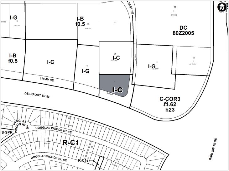
Background and Site Context
The subject parcel is located in the community of Shepard Industrial at the intersection of 118
Avenue SE and 35 Street SE, north of Deerfoot Trail SE and west of Barlow Trail SE. The
Green Line LRT alignment follows 114 Avenue SE to the north, with the nearby DouglasGlen
LRT Station expected to be located approximately 900 metres northwest of the subject parcel.
The surrounding area has a mix of industrial and commercial land uses comprised of Industrial
– Business f0.5 (I-B f0.5) District and Industrial – Commerical (I-C) District to the north and
west, with Commercial – Corridor 3 f1.62h23 (C-COR3 f3.0h46) District and Industrial – General
(I-G) District to the east.
The parcel is approximately 0.55 hectares (1.35 acres) and is accessed from 118 Avenue SE.
Irregularly shaped, the subject site is approximately 96 metres in length and 57 metres wide.
The parcel has an existing building that was constructed in 2001. The existing building is
approximately 10 metres in height and is approved for wholesale and retail businesses.
The South Pointe Toyota dealership is located east of the subject parcel on 35 Street SE. Rally
Pointe volleyball complex is to the north, and auto parts and furniture stores are located to the
west with Deerfoot Trail SE to the south. As indicated in the Applicant’s Submission (Attachment
2), the primary intent of this application is to add additional uses, specifically Vehicle Sales –
Major, to support the business operations of the nearby South Pointe Toyota dealership. No
development permit application has been submitted at this time.
Community Peak Population Table
As identified below, the community of Shepard Industrial reached its peak population in 1982,
and the population has decreased since that time.
Shepard Industrial
Peak Population Year 1982
Peak Population 424
2019 Current Population 255
Difference in Population (Number) - 169
Difference in Population (Percent) - 40%
Source: The City of Calgary 2019 Civic Census
Additional demographic and socio-economic information may be obtained online through the
Shepard Industrial Community Profile.
CPC2021-0236 Attachment 1 Page 1 of 5
ISC:UNRESTRICTEDCPC2021-0236
Attachment 1
Location Maps
CPC2021-0236 Attachment 1 Page 2 of 5
ISC:UNRESTRICTEDCPC2021-0236
Attachment 1
Previous Council Direction
None.
Planning Evaluation
Land Use
This application proposes to redesignate the subject parcel from I-G District to I-C District. The
existing I-G District allows for a wide variety of general light and medium industrial uses. Parcels
within the I-G District have limits on sales and office activities to preserve a diverse industrial
land base. The I-G District has a maximum floor area ratio of 1.0 and a maximum height of 16.0
metres.
The proposed I-C District is a land use district that allows for a wider range of compatible
industrial and commercial land uses on the parcel. The proposed I-C District is appropriate as it
is within close proximity of both Deerfoot Trail SE and Barlow Trail SE. Accordingly, the I-C
District contains rules and guidelines to ensure that developments provide an appropriate
transition between other land use districts and the I-G District. These provisions include
setbacks, screening, landscaping and building design controls that are intended to address the
aesthetics of more visible locations. The I-C District allows for a maximum floor area ratio of 1.0
and a maximum building height of 12.0 metres.
Beyond maximum building height and a slightly different suite of allowable uses, the key
difference between the I-C and I-G Districts is that the I-C District has no use area restrictions
for office and retail floor areas. This is in contrast to the I-G District rules where retail sales
activities and office uses are restricted to ensure that they are only ancillary components of the
principal I-G uses.
CPC2021-0236 Attachment 1 Page 3 of 5
ISC:UNRESTRICTEDCPC2021-0236
Attachment 1
Development and Site Design
Currently, the applicant is not seeking to change the layout or design of the existing site. The
intent is to use the existing building to accommodate the additional use of Vehicle Sales –
Major. The rules of the proposed I-C District will provide guidance for future development plans.
Transportation
Pedestrian access to the site is available via 35 Street SE and and vehicular acess is from 118
Avenue SE. The area is served by Calgary Transit Route 302 SE BRT, with a bus stop
approximately 300 metres north of the site on 114 Avenue SE. Route 302 provides transit
service every 20 minutes during the peak hours. The site is 900 metres from the planned
DouglasGlen LRT Station and is therefore not within the Transit Oriented Development
area. On-street parking adjacent to the site on 35 Street SE and 118 Avenue SE is not
regulated.
Environmental Site Considerations
There are no known outstanding environmental concerns associated with the subject site and/or
proposed scope.
Utilities and Servicing
Water and sewer services exist to the subject site and/or existing development. Public water,
sanitary and storm utilities exist immediately adjacent to the site. Development site servicing
requirements will be determined at the time of future development, to the satisfaction of Water
Resources.
Legislation and Policy
South Saskatchewan Regional Plan (2014)
The recommendation by Administration in this report has considered and is aligned with the
policy direction of the South Saskatchewan Regional Plan, which directs population growth in
the region to Cities and Towns and promotes the efficient use of land.
Interim Growth Plan (2018)
The recommendation aligns with the policy direction of the Calgary Metropolitan Region Board’s
Interim Growth Plan (IGP). The proposed land use amendment builds on the principles of the
IGP by means of promoting efficient use of land, regional infrastructure, and establishing strong,
sustainable communities.
Municipal Development Plan (Statutory – 2009)
The subject site is located within the Standard Industrial - Industrial Area as identified on
Map 1: Urban Structure in the Municipal Development Plan (MDP). The applicable MDP
policies encourage a broad variety of industrial uses and intensities that support the
industrial function of this area. Industrial areas must offer flexibility to support this variety
of uses – both those that currently exist as well as uses that may arrive in the future. The
proposal is in keeping with relevant MDP policies as the purpose of the I-C District is to
allow for small scale commercial uses that are compatible with and complement light
industrial uses. The I-C District provides a transition between other land use districts and
the I-G District.
CPC2021-0236 Attachment 1 Page 4 of 5
ISC:UNRESTRICTEDCPC2021-0236
Attachment 1
Climate Resilience Strategy (2018)
This application does not include any specific actions that address objectives of the Climate
Resilience Strategy.
Southeast Industrial Area Structure Plan (Statutory – 1996)
The subject site is located within the Proposed I-2 General Light Industrial District as
identified on Map 2: Land Use and Transportation Plan in the Southeast Industrial Area
Structure Plan. The applicable policies for the Proposed I-2 General Light Industrial
District encourage a range of light industrial and associated uses that are compatible
with each other and do not adversely affect surrounding non-industrial uses. The light
industrial uses are to be consistent with those which are allowed in the I-2 General Light
Industrial District under the Calgary Land Use Bylaw 2P80. The proposal is consistent
with the applicable policies.
CPC2021-0236 Attachment 1 Page 5 of 5
ISC:UNRESTRICTEDYou can also read