Background and Planning Evaluation - CPC2021-1195
←
→
Page content transcription
If your browser does not render page correctly, please read the page content below
CPC2021-1195
Attachment 1
Background and Planning Evaluation
Background and Site Context
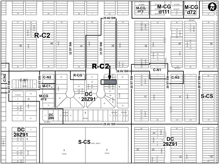
The subject parcel is located on the east side of 31 Street SW, south of 26 Avenue SW in the
community of Killarney-Glengarry. The site is approximately 0.05 hectares (0.12 acres) in area
and 15 metres wide by 35 metres deep. This site has direct access to a rear gravel lane along
the east boundary.
Surrounding development is characterized by a mixture of single detached and semi-detached
housing (designated under a DC District that is based on the R-2 Residential Low Density
District of Bylaw 2P80) on all sides.
Community Peak Population Table
As identified below, the community of Killarney-Glengarry reached its peak population in 2019.
Killarney - Glengarry
Peak Population Year 2019
Peak Population 7,685
2019 Current Population 7,685
Difference in Population (Number) 0
Difference in Population (Percent) 0%
Source: The City of Calgary 2019 Civic Census
Additional demographic and socio-economic information may be obtained online through the
Killarney - Glengarry Community Profile.
CPC2021-1195 Attachment 1 Page 1 of 5
ISC:UNRESTRICTEDCPC2021-1195
Attachment 1
Location Maps
.
CPC2021-1195 Attachment 1 Page 2 of 5
ISC:UNRESTRICTEDCPC2021-1195
Attachment 1
Previous Council Direction
None.
Planning Evaluation
Land Use
The existing DC District (Bylaw 28Z91) is based on the R-2 Residential Low Density District in
Land Use Bylaw 2P80 which accommodates development in the form of single detached, semi-
detached and duplex dwellings with a maximum building height of 10 metres. The DC District
includes a minimum lot width of 11 metres and a minimum lot size of 348 square metres.
The proposed R-C2 District accommodates existing residential development and contextually
sensitive redevelopment in the form of duplex dwellings, semi-detached dwellings, and single
detached dwellings. The R-C2 District allows for a minimum lot width of 7.5 metres, a minimum
lot area of 233 square metres, a maximum building height of 10 metres and the Secondary
Suite as a permitted use. Besides the Secondary Suite use, the rules of the R-C2 District are
effectively identical to those of the R-2 District.
Development and Site Design
If approved by Council, the rules of the proposed R-C2 District would provide guidance for the
development of the site, including appropriate uses, building height and massing, landscaping,
parcel coverage, and parking.
CPC2021-1195 Attachment 1 Page 3 of 5
ISC:UNRESTRICTEDCPC2021-1195
Attachment 1
Transportation
The subject site is located mid-block on a Residential class road, with less than 5,000 vehicle
trips per day. The subject site has direct lane access. The current parking supply on the site is
adequate for the proposed land use. The site is not currently within a Residential Parking zone,
and there are no on-street parking restrictions on 31 Street SW or on the south side of 26
Avenue SW. No on-street parking is permitted on the north side of 26 Avenue SW as there is a
bike lane.
The subject site is approximately 65 metres away from a bus stop on 26 Avenue SW, providing
service through South Calgary, Mount Royal, Beltline, and the Downtown core.
Environmental Site Considerations
No environmental site concerns were identified.
Utilities and Servicing
Water, sanitary, and storm deep utilities are available. Development servicing requirements
would be reviewed at the development site servicing stage.
Legislation and Policy
South Saskatchewan Regional Plan (2014)
The recommendation by Administration in this report has considered and is aligned with the
policy direction of the South Saskatchewan Regional Plan which directs population growth in the
region to cities and towns, and promotes the efficient use of land.
Interim Growth Plan (2018)
The recommendation aligns with the policy direction of the Calgary Metropolitan Region Board’s
Interim Growth Plan (IGP). The proposed land use amendment builds on the principles of the
IGP by promoting efficient use of land and regional infrastructure and establishing strong,
sustainable communities.
Municipal Development Plan (Statutory – 2009)
The subject site is identified as Developed – Inner City typology of the Municipal Development
Plan, which encourages redevelopment and modest intensification of inner-city communities to
make more efficient use of existing infrastructure, public amenities and transit. It also intends to
deliver small and incremental benefits to climate resilience. This proposal aligns with the
typology policy as it will effectively mirror the existing development rules for this parcel.
Climate Resilience Strategy (2018)
This application does not include any specific actions that address the objectives of the Climate
Resilience Strategy. Further opportunities to align development of this site with applicable
climate resilience strategies will be explored and encouraged at subsequent development
approval stages.
Killarney / Glengarry Area Redevelopment Plan (Statutory – 1986)
The subject site is identified as Conservation/Infill. This policy category provides for the form
and density allowed under the R-2 District that the existing DC is based on and as described
under Land Use Bylaw 2P80, which includes single-family detached, semi-detached, duplex and
converted structures containing no more than two units. This policy is designed to retain a low
density of dwelling units and the traditional home-built form while permitting infill development.
CPC2021-1195 Attachment 1 Page 4 of 5
ISC:UNRESTRICTEDCPC2021-1195
Attachment 1
This proposal aligns with this policy as the rules of the R-C2 District under Land Use Bylaw
1P2007 are effectively identical to the R-2 District rules. The Secondary Suite use is not
counted as a dwelling unit and therefore complies with this existing policy.
Westbrook Communities Local Area Plan (Under Development)
Administration is currently developing the Westbrook Communities Local Area Plan which
includes Killarney and other surrounding communities. Planning applications are being accepted
for processing during the local growth plan process. The Westbrook Communities Local Area
Plan is anticipated to be finalized in Q4 2022.
CPC2021-1195 Attachment 1 Page 5 of 5
ISC:UNRESTRICTEDYou can also read