SEVERE WEATHER ADVISORY - RELIEFWEB
←
→
Page content transcription
If your browser does not render page correctly, please read the page content below
Severe Weather Advisory
Severe Weather Advisory for Gulf of Aden (Yemen & Somalia)
Probable Tropical Cyclone Development
Issued on Wednesday, 16th May 2018 at 0130 local time.
Headline
A Tropical Cyclone is expected to develop at the eastern end of the Gulf of Aden in the next 24 hours (See
Figure 1). This is forecast to track westwards along the Gulf and bring exceptionally high rainfall totals to a
usually very arid region.
Note – the uncertainty in the track of this cyclone means that we remain unsure whether the heaviest rain
(and most severe impacts) will fall in either Southern Yemen, Northern Somalia, and there is a low risk that it
may impact upon Djibouti over the coming weekend.
Figure 1: European Centre for Medium Range Weather Forecasting (ECMWF) ensemble forecast tracks of the
tropical cyclone and probability plume (showing probability of a tropical storm strength cyclone (winds >35mph
passing within 120KM of a location).
Impacts
Severe flash flooding and river flooding across the region will lead to a loss of human life,
livestock, and the destruction of crops, property and infrastructure.
Very heavy rainfall occurring across Western Yemen (linked to, although not directly from the
cyclone) is likely to promote cholera infection rates in the weeks ahead.
This forecast may be amended at any time
mailto: GGU@metoffice.gov.uk
Phone Duty Forecaster, Global Guidance Unit (GGU), Operations Centre, Met Office, Fitzroy Road, Exeter
VPN n6225 4319, BT 01392 884319
Crown copyright 2018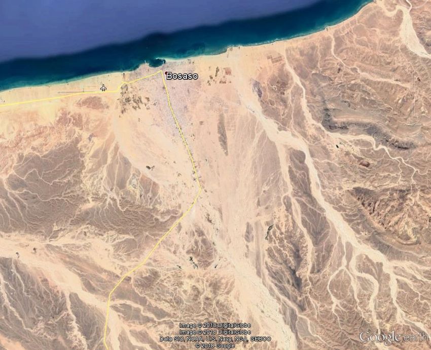
Severe Weather Advisory
Discussion
Meteorological Development: A small area of low pressure located close to Socotra Island has become
more organised and surrounded by active thunderstorms over the past 24 hours (See Figure 2). This area
is forecast to progress northwestwards into the Gulf of Aden, and it will remain in an area where the
conditions are favourable for the development of this low into a tropical cyclone over the next day or two.
Figure 2: The cyclone in its formative stages just to the northwest of Socotra Island at 0001 UTC on 16th May 2018.
Uncertainty in the track of the system (See Figure 1), from a westward path along the Southern Yemeni
coast, to a westward track along the Northern Somali Coastline leads to uncertainty about its likely
intensity For example, a track close to either coastline would see the mountainous terrain disrupting the
cyclone’s organisation. However, a track along the centre of the Gulf of Aden could allow significant
strengthening of the winds around the storm.
In the scenario of a track along the centre of the Gulf of Aden, it looks likely that precipitation totalling
between 50-100mm will fall over both the coastal strips of Yemen and Somalia, with a close pass or
landfall from this system leading to a risk of rainfall totals exceeding 250mm.
Model Guidance: In recent days, the trend has slightly favoured a weak cyclone passing slightly further
south, taking the very heaviest precipitation away from Southern Yemen and into Northern Somalia (and
potentially into Djibouti by the weekend)
Even with this latest southwards trend, 25-50mm of precipitation is still expected widely along the
southern Yemeni coastal strip, with isolated peaks in excess of 100mm. This area usually receives close
to zero precipitation, so this will still give large flooding related impacts.
Across Northern Somalia, 50-100mm of rain could fall widely, with peaks in excess of 250mm (See Figure
3). Again, this area usually receives little rainfall away from the Ogo Mountains.
This forecast may be amended at any time
mailto: GGU@metoffice.gov.uk
Phone Duty Forecaster, Global Guidance Unit (GGU), Operations Centre, Met Office, Fitzroy Road, Exeter
VPN n6225 4319, BT 01392 884319
Crown copyright 2018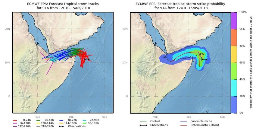
Severe Weather Advisory
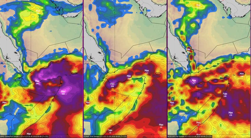
Figure 3: Forecast rainfall totals in mm from the three best performing Weather Forecast Models. Met Office Global
Model (left), European Model (Centre), the American GFS Model (Right). All currently highlight that Northern
Somalia is likely to see the heaviest precipitation.
Satellite imagery on Google Earth, shows settlements and agriculture on dried up river beds, putting both
people and livestock at a high risk of being caught out by flash flooding.
Figure 4: The city of Bosaso in Northern Somalia is home to an estimated 165,000 people. Note the number of dried
up river beds surrounding the city.
This forecast may be amended at any time
mailto: GGU@metoffice.gov.uk
Phone Duty Forecaster, Global Guidance Unit (GGU), Operations Centre, Met Office, Fitzroy Road, Exeter
VPN n6225 4319, BT 01392 884319
Crown copyright 2018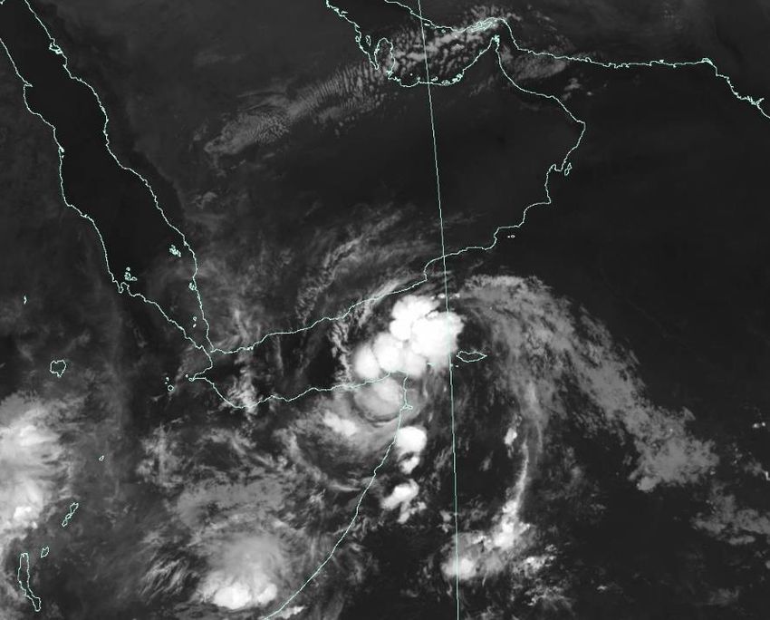
Severe Weather Advisory
Historical Perspective: Similar events in recent years in both Yemen (2008 Cyclone) and Somalia (2013
Cyclone) have led to hundreds of human fatalities, the large scale loss of crops, livestock and destruction
of property and infrastructure. The current forecast event appears to be as severe as the 2013 Somali
Cyclone, but slightly below the severity of the 2008 Yemen Cyclone. However, much will depend upon the
track of the cyclone over the coming days.
Likely Impacts: It must be stressed that heavy rainfall will cause the most impact from this cyclone, with
impacts likely in Southern Yemen and across much of Northern Somalia. In an area that usually sees little,
and often no rainfall, dried up river beds are settled by people and extensively used for agriculture (crops
and livestock). Modest amounts of precipitation would bring flash flooding to these areas, with people,
animals and crops in these flooded zones likely to be washed away. With large amounts of rainfall likely
over the coming days, there is the potential for very serious impacts on the region.
Thunderstorms, indirectly linked to the cyclone, are also likely to affect western Yemen over the next
week. This is likely to have negative implications for the management of the ongoing cholera epidemic.
Sources: UKMO GM, ECMWF, NOAA GFS, EUMETSAT, Google Earth.
Issued at: 160030 Z Meteorologist: Nick Silkstone Global Guidance Unit
This forecast may be amended at any time
mailto: GGU@metoffice.gov.uk
Phone Duty Forecaster, Global Guidance Unit (GGU), Operations Centre, Met Office, Fitzroy Road, Exeter
VPN n6225 4319, BT 01392 884319
Crown copyright 2018You can also read