Bedload Transport and Gravel Supply in the Waiapu Catchment
←
→
Page content transcription
If your browser does not render page correctly, please read the page content below
i

Bedload Transport and
Gravel Supply in the
Waiapu Catchment

Steps toward a framework for
managing gravel extraction

Apr 26, 2021

Jon Tunnicliffe and Danny Baucke
The University of Auckland
School of Environment
ii
iii

Executive Summary

REPORT OBJECTIVES

 • This report identifies issues regarding gravel extraction on the Waiapu River, and
   proposes some steps towards developing a sustainable management framework.
   The report further aims to inform best practices for gravel extraction, with a view to
   enhancing community engagement with decision making, managing water quality
   issues, and nurturing the development of river habitat.

 • The report is framed using five interconnected elements that must be considered prior
   to establishing a programme of extraction: Community Values, Environment & Eco-
   system, River Morphology, Protective Works and Cumulative Impacts.

 • Under the 2015 Joint Management Agreement (JMA), an agreement between Ngāti
   Porou and Gisborne District Council, the extraction consenting and resource alloca-
   tion process will engage hapū and landowners more closely and will be a guided, over-
   arching management programme for the river. River management and Te Mana o Te
   Wai require all decision-makers and users to appreciate relationships to - and values
   held of - the river. This report reviews criteria to be visited by the consenting authority
   when considering applications for gravel extraction.

 • The report provides an overview of river geomorphology and its links to ecology, river
   connectivity relationships within the drainage network, and an approach to assessing
   sensitive sites along river corridors and sustainability of the proposed activity. Some
   perspective on adaptation in a changing climate is outlined: gravel supply is ultimate-
   ly determined by storm climate, and therefore extraction regime should reflect this
   variation.

 • We review some of the options for flood control and managing aggradation within the
   river system. It can be challenging to remove gravel in the places where this is need-
   ed (downstream from gully complexes, mainly), in a sustainable manner that is also
   economically feasible.

 • Monitoring of the river system has become faster, more detailed, and less expensive
   with LiDAR and drone survey technology. In addition to bed topography, ecological
   and bed texture monitoring should be implemented as part of annual site review. We
   highlight this with two case studies from the study catchment: the Tapuaeroa, and
   the Waiapu. Topographic differencing over a one year interval shows typical rates
   of sediment transfer, and determines the sustainability of the extraction rate. These
   results can also be used to provide validation for 1D and 2D numerical models of
   sediment yield, which in turn can help with longer-term catchment planning.

iv
     ISSUES IDENTIFIED

     Hapū Values/Community Values
      • Activity must be guided by initial engagement and ongoing interaction, particularly
        with Hapū and Iwi and also the wider community. Custodial linkages with the river
        are expressed through kaitiakitanga (guardianship), mana whenua and with an
        acknowledgement of ancestral linkages that position people as part of landscapes and
        ecosystems (Marsden, 2003). The term ‘community’ here is defined as all those living
        in, having a cultural relationship with, or holding significant interest in, the Waiapu
        catchment. In light of the ambitions for the JMA, gravel extraction or any other
        proposed modification of the river must be addressed through broad consensus.

      • Economic opportunity needs to be balanced with the vision for river restoration.
        Assessment of employment and economic gains from aggregate industry, and
        cascading effects for construction and forestry should be carried out.

      • A catchment management plan that is both scientifically informed and driven by
        Hapū aspirations and community consensus is needed to clearly define targets for
        managing both site-specific and catchment-wide issues, including impacts from river
        aggradation. Different tributaries will have different considerations, from a commu-
        nity or Hapū values perspective. Plans for each takiwa (hapū collective) should be
        developed.

     Environment and Ecosystem

      • The ecology of the Waiapu River and its tributaries, and the potential for recovery to
        pre-forest-clearance levels, is not very well characterised. In order to manage the risks
        of habitat degradation in a gravel extraction operation, it is important to understand
        spawning/nesting, rearing and feeding requirements of existing (and potential) bird,
        fish, and macroinvertebrate species, as well as linkages in the riverine/riparian food
        web.

      • Best practices for monitoring impacts from gravel extraction should include
        consideration of bed substrate conditions (invertebrate populations, median grain
        size, abundance of fines) and the diversity and relative abundance of hydraulic
        environments (riffles, pools).

      • Riparian zones are important buffer areas between the river and floodplain ecosys-
        tems; these are sites of exceptional species diversity (e.g. Gray and Harding, 2007).
        Terrestrial macroinvertebrates and organic detritus from these zones serve as a food
        source and moderate the aquatic food web. There is no clear policy for protecting,
        rehabilitating and/or enhancing these sites in the design of gravel extraction schemes.

      • The parafluvial zone is the area adjacent to active channels with subsurface flow. The
        area represents important connectivity for nutrients and longer-term storage of river
        base flow. Protecting underground water pathways has been highlighted as an impor-
        tant priority in traditional management of the river (Scion, 2012).

      • Air quality has been reported to be an issue, as dried silt particles from the river bed
        are easily entrained by strong winds in the valley. The issue is exacerbated by gravel
        extraction operations, with heavy trucks moving long distances over the floodplains.
v
ISSUES IDENTIFIED (CONT.)

Cumulative Effects
 • Multiple operations over time: current rates of consented extraction within the catch-
   ment have reached nearly 450 000 m3 per year (roughly 150 000 m3 in the mainstem
   river) as of February 2020. This is in significant excess of the estimated minimum rates
   of net bedload transfer for the mainstem - which vary widely - but were assessed to be
   about 35-45 000 m3∙yr-1, based on repeat photogrammetric river bed surveys in 2019-
   2020. If drawing down bed levels is the management aim, then a sediment budget and
   a practical assessment of extraction rates should be developed.

 • Multiple operations in space: potential locations for extraction operations are
   constrained by transport distances, quality of the gravel, access to the river, land
   ownership, available terrain for stocks, screening and loading, and other factors. A
   majority (~81%) of the gravel extraction efforts have been focused on the Mata (41%)
   and Waiapu (40%) rivers. Since there has been no aggradation on the Mata since 1997
   (Peacock, 2016), there seems little justification for continuing to remove sediment at
   high rates here. Most of the riverbed aggradation in the catchment is occurring within
   the Tapuaeroa Valley. Only about 8% and 12% of abstractions are currently sourced
   from operations within the Tapuaeroa and Mangaoparo, respectively.

River Morphology and Sustainable Sediment Supply
 • The lower river and the many tributaries that feed into it all have a distinctive trans-
   port regime and character, and extraction conditions should reflect this. Different
   river morphologies (e.g. confined headwaters, meandering, braided) will have dif-
   ferent disturbance histories, ecology, and susceptibility to disturbance. Response to
   gravel extraction will vary according to factors such as channel slope, sediment supply,
   floodplain storage dynamics, substrate quality and texture. Criteria for selecting
   extraction sites, and operational procedures for the extraction work should reflect the
   river character.

 • A river with a sediment deficit will begin to reduce its active width, entrench its bed
   and simplify its morphology. A river deprived of sediment has excess energy and
   typically erodes its bed and banks to regain that sediment load (Kondolf, 1994). An
   example from the Aorongiwai River (tributary to the Mata) shows significant vertical
   bed erosion, where extraction rates from a short-lived operation there were in signifi-
   cant excess of the annual yield.

Protective River Works
 • In the right circumstances, extraction works can be used to improve flood convey-
   ance, protect bridge infrastructure, and to coax a river channel away from an eroding
   river bank. In 2010, gravel extraction was employed as part of an effort to move the
   river away from an eroding bluff near Ruatoria, for instance. While this can be very
   useful, the timeframe and location of the works may make it difficult to build an af-
   fordable or profitable enterprise from this.

 • A review of potential sites that might benefit from rehabilitative gravel removal
   should be developed, in consultation with the community.
vi

     CONCLUSIONS AND RECOMMENDATIONS

     • With the implementation of a Joint Management Agreement, extractive activities
       should be designed in a collaborative way with the affected community, moderated via
       the local consenting collective.

     • A catchment Gravel Management Strategy should be developed, assimilating the
       available information on bedload transport rate, cross-section change, and communi-
       ty concern for the river’s health and mauri. A map of sensitive riverine environments
       should be developed to proactively manage the gravel resource.

     • Surveys of stream fauna and flora, as well as terrestrial and bird life are limited, but
       show some of the abundance and diversity that is expected of this unique braided river
       habitat (Wilson, 2001; Gray and Harding, 2007; Roil and Death, 2018). Guidelines
       for protecting riverine habitat are based on current conditions, but given aspirations
       for moving the Waiapu toward a more desired environmental state (cf. Scion, 2012)
       consideration should be taken of the potential conditions, as the deleterious effects of
       erosion and landuse are progressively mitigated.

     • The effects of natural variation in annual gravel yield has not been accounted for in
       gravel extraction plans: consents should be tied to flood intensity and duration (thus
       bedload yield) for a given year. Recharge rates for 2019-2020 were shown to be very
       low, relative to ongoing extraction rates.

     • Extraction may be promoted as a useful means for mitigating the deleterious effects
       of river aggradation. Extraction sites should be located within aggrading reaches, with
       clearly identified sediment influx rates and source areas, with clear criteria for allocat-
       ing extraction volumes.

     • Most of the currently aggrading reaches are found within the Tapuaeroa, Mangaoparo
       and some parts of the Waiapu mainstem (cf. Peacock 2017). Given the goal of coun-
       tering the effects of sediment over-supply, a detailed management plan should address
       how best to leverage extraction efforts in the affected locations.

     • Monitoring should include site surveys, grain-size surveys, and ongoing census of
       riverine biota. Adaptive management is required to assess the trajectory of any river
       reach under extraction. Operation should cease or relocate, if the local gravel deficit is
       impacting the channel in ways that were not foreseen.

     • Where in-stream extraction is seen as a means to managing sediment surplus, extrac-
       tion should proceed with fine sediment management and protection of riparian river-
       bank environments in mind. Operations that source gravel from older deposits, out of
       the range of base flows to flood flows, will have lower impacts on riverine habitat.

     • An expanded programme of monitoring and research is needed in order to better
       understand effects of gravel extraction on the ecology of Waiapu rivers. Further studies
       of channel change in response to abstraction works would also be highly beneficial;
       researchers collaborating with extractors to refine extraction techniques will be par-
       ticularly effective.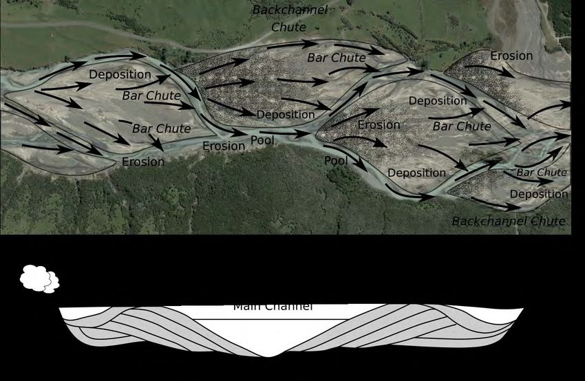
vii

Bedload Transport and Gravel Supply in the Waiapu Catchment:
Steps toward a framework for managing gravel extraction

Citation:
Tunnicliffe JF, Baucke D. 2021. Bedload Transport and Gravel Supply in the Waiapu
Catchment: Steps toward a framework for managing gravel extraction. Gisborne District
Council. Available from: http://www.gdc.govt.nz/reports/.

Acknowledgments
This report is partly based on ongoing investigations of sediment transport within the
Waiapu Catchment. Though the summaries and conclusions reached (including any errors
or omissions) in this report are our own, we gratefully acknowledge assistance, analysis and
insights from Pia Pohatu, Tina Porou and Tui Warmenhoven and others within the Waiapu
Community. Manu Caddie has long supported our work, and has provided a number of
photographs in this report. Thanks to Luke Donnelly and Wendy Rusk for logistical support
during our research in the area.

We thank Gisborne District Council for the provision of LiDAR data, and an exceptional
set of river cross-section data. Thanks to Murry Cave for the encouragement and support to
write up this review. The work was funded by an MBIE Envirolink Medium Advice Grant to
Gisborne Council (2051-GSDC160).

Prof. Gary Brierley, University of Auckland, has provided advice to the authors over the
course of this work, and his contribution is gratefully acknowledged. Field support has been
provided by Brendan Hall, Chris Turner, and Niraj Bal Tamang.

Thanks to Kristiann Allen, Koi Tū Centre for Informed Futures (informedfutures.org), for
helping us to develop the interaction ribbon diagrams that serve to convey the complex
relationships in resource management decision-making.

Sofia Minson from newzealandartwork.com has very kindly given permission to reproduce
her original artwork on pages 8-9.
viii

       Table of Contents
       Executive Summary                                                               iii
       Acknowledgments                                                                 vii

       Catchment Map        9

       1. Waiapu Koka Huhua: Waiapu Of Many Mothers                                    10

       2. The Interwoven Effects of Extraction Activity on Rivers                      12
       2.1 Community Connections to the River 14
       2.2 River Ecosystems and Environment       18
       2.3 Cumulative Effects 24
       2.4 River Morphology and Sustainable Sediment Supply     30
       2.5 River Engineering and Protective Works 36

       3. Managing and Monitoring Gravel Extraction in the Waiapu                      40

       4. Implications for an Integrated Catchment Management Plan                     53

       5. Conclusions and Some General Recommendations                                 57
       5.1 Community          58
       5.2 Environment        58
       5.3 Cumulative Effects 58
       5.4 River Morphology and Sustainable Sediment Supply     59
       5.5 Protective River Works 59
       5.6 Recommendations 59
       5.7 Open Avenues for Investigation 61

       References and Resources                                                        62
       Gravel Extraction Guidelines from other NZ Regional Councils:   62
       Cited References     64

       Appendix 1: Summary of River Status     69
       Appendix 2: Condensed Summary of Potential Impacts from Gravel Extraction   70
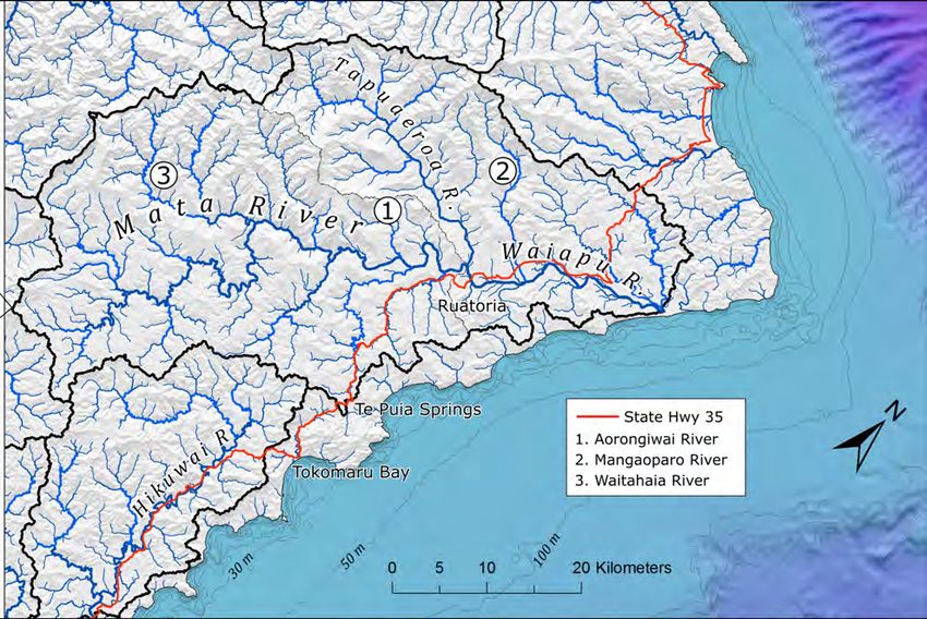
9

   Catchment Map

The Waiapu Catchment, with a few sites referenced in the text
highlighted.
10

     1. Waiapu Koka Huhua:
        Waiapu Of Many Mothers
     Ko Hikurangi te maunga
     Ko Waiapu te awa
     Ko Ngāti Porou te iwi.

     The Waiapu River is a symbol of Ngāti Porou identity, as expressed in the above pepeha.
     The river is an important self-identifying feature of the Iwi and of individuals. The river
     is situated at the heart of the rohe of Ngāti Porou, and is of great cultural significance to
     its people. The community within the valley have long been responsible for protecting
     the mauri of the river. The term ‘community’ here is defined as all those living in, hav-
     ing a cultural relationship with, or holding significant interest in, the Waiapu catchment
     (Harmsworth et al., 2002).

     A common prefix in river and stream names in the valley is ‘manga-’, reflecting the
     branched connectivity of the system; this report emphasises the diverse character of
     many of these branches. The Māori place names of the many streams and rivers reflect
     the identity of each system, and should be considered as more than merely superficial
     impressions of river characteristics. The name Waiapu means ‘to gobble up, to consume’:
     the remarkable power of the river to devour floodplains, and to transfer large quantities
     of material, is a defining characteristic. Starving the river would seem antithetical to its
     nature. Tapuaeroa means ‘the long sacred footstep’. This river gathers a remarkable sedi-
     ment load from rivers draining the Raukumara range front and carries it 20 km along the
     valley, where it joins with the Mata River to form the Waiapu.
11 “The Garden of Waiapu“ Artwork by Sofia Minson, oil on canvas, ©2007 newzealandartwork.com Reproduced with permission. More importantly, these many branches are connected, and removal of a resource from any of the up- per branches will eventually affect the lower trunk, and so management and planning must proceed on this basis. The river is considered to be an interconnected, living being that cannot simply be un- derstood as a collection of measurable or definable parts. Rivers are a complex and emergent network of plants, animals, land, water and people in a dynamic process of coevolution (Salmond, 2018). Every branch of the river has a history. The signature of past changes and disturbance can be discerned in abandoned channels, broad sediment storage zones, high terraces, sediments of variable provenance, and other remnant evidence. Recovery and rebalancing is still in play at many locations. Ecological assemblages and channel morphology have organised according to the magnitude and frequency of such disturbances. Any branch’s predisposition to change will be determined by this regime. This also must be considered when contemplating resource extraction. As well as having a history, the river is also an ancestor. It has its own life force, authority and prestige, and sacredness (Brierley et al., 2018). This ancestral linkage positions people as part of the landscapes and ecosystems (Marsden, 2003). There is a strong sense of the importance of passing this resource on, undiminished, to the next generation. Therefore the importance of sustainable management: the fluxes and flows of riverbed substrate should be well understood before consenting to remove material. Finally, rivers are taonga of whānau, hapū and iwi both from a physical and spiritual perspective. The river has long been “a valuable food resource to those who possess it, which carries its own separate mauri (life force) and is guarded by the taniwha that inhabit it. The physical cannot be divorced from the metaphysical; the two are inseparable.” (Te Ika Whenua Rivers Report, Waitangi Tribunal 1998).
12

     2. The Interwoven Effects of
        Extraction Activity on Rivers
     Rivers are naturally adjusting systems that adapt over years to decades to changes in
     sediment supply; there are many well-documented examples of the ways in which river
     morphology will respond to a surplus or deficit of material provided from the headwa-
     ters of the catchment. Historic cycles of climate change, for instance, can lead to gradual
     metamorphosis from braided to meandering river morphology. Systematic removal of
     sediment supply, if not carefully managed, may also lead to changes in river morphology,
     in turn leading to changes in river habitat, ecological relationships, and human interac-
     tions with the river. Erosion issues, and impacts on property and infrastructure may be
     further unintended consequences of gravel extraction.

     The communities within the greater Waiapu catchment have a strong interest in protect-
     ing the river and fostering the well-being of freshwater ecosystem. The river and its tribu-
     taries are inextricably tied to the identity of Iwi and Hapū. People have deep linkages to
     the river and its ecosystem through long-held customs of kaitiakitanga (guardianship).
     The Waiapu provides rare habitat, one of the few large and wild braided-to-wandering
     gravel bed systems on the North Island. It has not been as severely impacted by gravel
     and water extraction as others in New Zealand. While there are economic opportunities
     to be had in gravel extraction, there are many important linkages to be considered.

     When planning extraction activities on a river system, it is important to take into con-
     sideration these numerous, complex linkages (Figure 2.1). Each category in the figure
     consists of multiple sub-components: Community Values, for instance, includes the
     initiative for self-determination, economic opportunity, fishing and other harvesting
     opportunities, scenic value, and nurturing the mauri of the river. Interactions amongst
     components can be constructive or in tension (or potentially both): in the following
     sections we follow some of the major strands that could be problematic in the course of
     gravel extraction from the river.
13
u es En
V al vi
ro
ty n
m
i
un
en
m
t
m
Co
Effects
Pro
ive
tec
at
tiv
ul
m
e
Cu
W
rk
o
s
lo gy
River Mo rpho
Figure 2-1 - Framework of interacting effects of gravel extraction on Community Values, Environment, and River
Morphology, with consideration of suitably aligned Protective Works and possible Cumulative Effects from mul-
tiple operations over time and across space. The strands consist of many subcomponents (not pictured) that will
interact across the various categories in various ways: both tensions and practical synergies. Matauranga perme-
ates across all these relationships, as represented by the interwoven “Maui” motif (modified from Tamati Ngaka-
ho, decorator of Ropata Wahawaha’s famous house “Waiomatatini”, on the Waiapu River. National Library, Tiaki
IRN: 233561). This is the fundamental basis for management of the river.
The Environment category includes air and water quality, ecosystem health, species abundance and
diversity, and nutrient availability. Cumulative effects are particularly important, as extraction activity
can impact other system components through repeated takes by different operators over time, along
the same river reaches. A deficit of material can migrate quickly through the network, interacting
with natural erosion processes and exacerbating the effects of shortages in other parts of the catch-
ment over time. River morphology is responsive to sediment supply conditions; a river may narrow
and simplify its character with a sediment deficit, leading to changes in habitat diversity and availabil-
ity. Finally, gravel extraction has also been used as a management tool, in order to coax the river away
from property or key infrastructure, or to reduce the likelihood of flooding in a particular site. Protec-
tive works must also be managed in the context of a broader management plan, since such extractions
must be adaptive (responding to fluctuations in river conditions), coordinated, and dedicated over
time. Lastly, all strands are interwoven with principles of kaitiakitanga, mātauranga, sustainability,
respectful dialogue and strategic economic vision.14
u es En
V al vi
ro
ty n
m
i
un
en
m
t
m
Co
ts
Effec
Pro
ive
tec
at
tiv
ul
e
m
W
Cu
rk
o
s
lo gy
River Mo rpho
2.1 Community Connections to the River
Just as there is a diversity of river morphologies along the numerous tributaries of the
Waiapu, there is a diversity of values and viewpoints on how best to conserve and man-
age the system; the community has been contributing to a long-running process of devel-
oping a common vision for the Waiapu and integrating tikanga (indigenous laws and
values) into river governance and management.
Proponents contemplating extraction works on the river must engage in meaningful di-
alogue with local Hapū, and look to align the work with the broader management vision
for the river. This process cannot be bypassed in implementing extraction works on the
river. Concerns over extractive practises on the river have long been expressed by com-
munity members, and there is a strong collective sense that management of the river has
not adequately taken consideration of the holistic health of the river and its people (see
Porou et al., 2012, p.229). These concerns have not been allayed or addressed, to date.
As an outcome of lengthy and extensive consultation with the community, Porou et al.
(2012) provide a summary of the consensus on a desired state for the Waiapu River,
which is worth citing here:15 “Ngāti Porou have identified that they desire a river that is clean, has drinkable water, and flows freely — a river where Ngāti Porou can swim, play, and enjoy the waters safely to contribute to the re-invigoration of the relationship between the people and the environment. They envisage a future in which they have control over the river and its catchment as kaitiaki and have the ability to decide and influence the protection and sustainable use of the Waiapu, and through this influence they could reduce the sources of pollution to the awa and use matauranga that was honoured, respected, and relevant to restore the catchment. Ngāti Porou want a river that is again a kapata kai, bountiful with flora and fauna to sustain Ngāti Porou and, in turn, for Ngāti Porou to sustain the river. They desire a future in which Ngāti Porou again understand the intimate relationship that the people once had with the River and, through this improved understanding, take greater responsibility for their land use choices and how they affect the Waiapu, and create economic opportunity through innovation and sustainability to improve the lives and incomes of Ngāti Porou people... Finally, Ngāti Porou want to ensure that they do not pass the River onto future generations in a state worse than its current state — to at the very least, do no further harm to the River and its catchment.” Figure 2-2 Cooling off in the Mata River. Photo Credit: M. Caddie. The Joint Management Agreement (JMA) The Resource Management Act (RMA) was amended in 2005 to strengthen the role for Māori, by creating an obligation to consult with tangata whenua in the preparation of a proposed policy statement or plan if they may be affected by the policy or plan. A further amendment provided for public authorities and Iwi to enter into “joint man- agement agreements” under which decisions taken have the legal effect of a decision of the local authority. In 2015, as a response to a long-held desire for greater voice in resource decision-making and better self-determination, Te Runanganui o Ngati Porou and Gisborne District Council entered into a Joint Management Agreement for the Waiapu Catchment. This enables the two agencies to jointly carry out the func- tions and duties under Section 36B of the RMA, and other legislation relating to all
16   land and water resources within or affecting the     The framework has been initiated in response to
     Waiapu Catchment. The agreement builds on the        the different freshwater values and demands to be
     work of the existing Waiapu Kōkā Hūhua part-         managed within the Ngati Porou rohe. It will be a
     nership between the Council, Te Runanganui o         Regional Plan under the Resource Management
     Ngati Porou and the Ministry of Primary Indus-       Act 1991 (RMA), and will provide key resource
     tries to restore the Waiapu Catchment.               management direction for the management of
                                                          freshwater and natural resources in the Waiapu.
     Council and Te Runanganui will make the fol-
     lowing decisions jointly in accordance with this     Embodying a full partnership approach means
     JMA:                                                 the plan will be co-designed and co-written by
                                                          Ngati Porou and the Gisborne District Council.
     •   decisions on notified resource consent appli-    Sharing decision-making powers and responsi-
         cations under section 104 of the RMA within      bilities with Ngati Porou over natural resources
         the Waiapu catchment                             in the Waiapu Catchment provides more op-
     •   decisions on RMA planning documents              portunities to utilise and sustainably manage
         under clause 10(1) of Schedule 1 of the RMA      resources for the benefit of all the people living in
         that affect the Waiapu catchment, including      the Waiapu Catchment area (National Nati News,
         the Waiapu Catchment Plan                        2019).
     •   decisions on private plan changes within, or
         affecting, the Waiapu Catchment                  This report is designed to provide some input on
                                                          the issues related to extraction of gravel, which
     The Ngati Porou, Gisborne District Council JMA       has so far not had much technical attention.
     differs from other JMAs, in that it applies to all
     the freshwater, air and land within the Waiapu
     Catchment. This JMA will provide a model for         Economic Benefits
     the recognition of Iwi rights and interests in       The positive benefits of gravel extraction should
     freshwater, as well as provide a practical ‘col-     be considered alongside any adverse effects. Posi-
     laboration vehicle’ to enable effective, inclusive   tive effects include:
     and robust management of freshwater and land         • the provision of direct and indirect employ-
     resources, within the Waiapu Catchment.                  ment opportunities
                                                          • contribution to economic and social devel-
                                                              opment through the provision of materials
     Te Mana o te Wai                                         to maintain and enhance roads, particularly
     Te Mana o te Wai is a framework to guide fresh-          within the forestry sector.
     water management, including allocation. The          • diversification of the local economy and sup-
     NPS-FM 2020 provides strong direction to local           port of ancillary services such as engineering,
     authorities to give effect to Te Mana O Te Wai           road works and construction businesses
     Freshwater Plan. Resources must be managed           • the reduced social and economic costs of hav-
     in a way that gives effect to Te Mana o te Wai           ing aggregate resources closer to demand
     through:                                             • enhanced flood and erosion protection
                                                              through the removal of excess aggregate from
     •   involving tangata whenua                             the riverbed
     •   working with tangata whenua and                  • other flow-on regional benefits, including
         communities to set out long-term visions in          complementary businesses or services.
         the regional policy statement, and
     •   prioritising the health and wellbeing of water   Substantial capital investment is usually required
         bodies firstly, then the essential needs of      for excavation, sorting, screening and transport
         people, followed by other uses.                  equipment. Firms in the industry require trucks,
                                                          excavating equipment, washing and screening
     Involving tangata whenua and engaging com-           facilities and conveyor belts. Demand for aggre-
     munities and kaitiaki to be more proactively         gate is rising, and the economic model is becom-
     involved in the governance and management of         ing increasingly favourable for extractors (Leask,
     the wai is central.                                  2018; Zaki, RNZ, 2018).
Community Values: 17
The Mauri of the River
The study by Scion (2012) indicated that de-
forestation and land development over the last
120+ years have had an enormous impact on
cultural values and Maori well-being through
spiritual loss, degradation and reduction in the
area of natural resources, decreased access to
traditional resources, increased flooding risk, loss
and deterioration of culturally significant flora
and fauna habitats, loss and modification of cul-
tural sites and tikanga (practices associated with
those sites and resources), and the continuing
decline in the mauri (life force or health) of the
river and the quality of its resources through the
deposition of enormous quantities of sediment.
The concept of mauri encompasses multiple
aspects, beyond the river itself: the larger catch-
ment system, the associated cliffs, hills, river flats,
lakes, swamps, tributaries, and all other things
that serve to show its character and form. It is
reflected in its people, as well. It is important
tangata whenua are involved in environmental
decision making and planning. As kaitiaki of the
Waiapu River (or the specific tributary therein),
the community follows an obligation to maintain
the mauri of the river.
Figure 2-3 Looking downstream on
the Waiapu River, close to Tutara Hill.
Photo Credit: M. Caddie.
Key Messages
• Self-determination on questions of river management has been a long-held aspiration for
local Hapū and Iwi, and the wider community. The Joint Management Agreement provides a
mechanism for consultation and consensus on extractive activities on the river.
• Te Mana O Te Wai is a management framework under development that will encourage tangata
whenua, community and kaitiaki to become more involved in governance and management of the
wai.
• Economic benefits may be realised from gravel extraction, and market conditions are favourable
for development of the resource, but an improved consultation and decision-making process is
needed to target appropriate river deposits.
• Insights from matauranga can be brought to the decision-making process, as well as an expanded
and accessible scientific information base.18
u es En
V al vi
ro
ty n
m
i
un
en
m
t
m
Co
ts
Effec
Pro
ive
tec
at
tiv
ul
e
m
W
Cu
rk
o
s
lo gy
River Mo rpho
2.2 River Ecosystems and Environment
Braided rivers are notable for their biodiversity values; they naturally support highly
specialised and diverse assemblages of flora and fauna (Wiser et al., 2013). A key concern
in managing the Waiapu and its tributaries is maintaining the integrity of riverine habitat
and thus the ecosystem. While East Coast fish and invertebrate populations have been
determined to be lower than elsewhere in New Zealand (Rowe et al., 1999), there is good
potential for rejuvenating aquatic populations as land use practices change and afforesta-
tion takes hold within the catchment. The low-gradient reaches closest to the coast have
particularly good prospects for recovery.
Varied and complex hydraulic environments such as riffles, pools and backwater refugia
are vital habitat areas for fish and macroinverterates (e.g. insects, crustaceans, molluscs,
worms and leeches). Hughey et al (2011) identified the lower Waiapu as a site of Regional
Significance (the highest rating among Gisborne District Rivers). They noted abundant,
good quality habitat, and sightings of stilt, dotterel and Caspian tern. The Waiapu has
several fish species such as longfin eel, torrentfish, giant kokopu, koaro, inanga, short jaw
kokopu and redfin bully. Duncan and Sykes (2015) note that while there is an abundance
of good physical habitat and ideal hydraulic environments in the Waiapu and its tribu-
taries, fish populations are limited by food availability, due to turbid waters and drapes
of sediment on the riverbed. Richardson and Jowett (2002) offer the further observation
that fish abundance is most strongly linked to stable stream morphologies with low
bedload transport rates, providing some indication that managing surplus sediment may
have some directly beneficial effects on fish populations.
In their survey of invertebrate communities within braided river systems, Gray and
Harding (2010) have shown that, in surveys of 11 braided rivers, from the southernmost
South Island to the Waiapu, the Waiapu had the lowest overall taxonomic richness for
macroinvertebrates, roughly half the abundance of the highest scoring Wairau River.Anecdotal accounts summarised by Harmsworth River Substrate 19
et al. (2002) relate that the Waiapu River and its Coarse substrate is very important for native
major tributaries were able to support a healthy species that inhabit New Zealand rivers.
population of fish and eel around the turn of Richardson and Jowett (2002) showed that fish
the century, and up until about the 1950s. The abundance and diversity in East Cape rivers
Waiapu River was considered a major source of tended to drop off as sediment load increased,
kai to Ngāti Porou, and eel (tuna) was a dietary remarking that it is deposited sediment, rather
staple. Kokopu and inanga (whitebait) were pres- than sediment in suspension, that may most
ent up till the 1960’s in the Waiapu, Makarika, strongly limit habitat availability for fish. Fine
Tapuaeroa and Mareahara Rivers. In pre-Euro- gravel, sand, and silt-sized bed material filling
pean days, the Raparapaririki Stream (and other spaces between the larger rocks tends to limit the
tributaries to the Waiapu) supported a popula- ability of fish to feed. Diatoms cannot flourish in
tion of eels (Harmsworth et al., 2002; Peacock & these silt-laden environments, further limiting
Marden, 2004), and the literal translation of the resources for macroinvertebrates. Spawning
name means “small eels hung out to dry”. opportunities are reduced for some species.
Thus the importance of managing extraction
Prior to Cyclone Bola in 1988, tributaries to operations such that concentrated inputs of
the Waiapu (specifically the Tapuaeroa Riv- fine material do not accumulate in key riverbed
er and Raparapaririki Stream) were typically habitats.
“steep bouldery mountain torrents” (Peacock &
Marden, 2004), and in the 1970’s and 1980’s were Natural river gravel deposits tend to have a
known to support a population of trout. Kokopu, coarser surface layer that has been worked (‘win-
inanga and eels are still present in some upper nowed’) by flood flows, and thus has little matrix
river reaches that are not laden with silt, such material. Skimming removes this surface layer
as the Maraehara. However, the populations are of sediment, which may favour bed erosion and
much reduced, and have disappeared completely increasing local bedload transport (Figure 2-4;
from some tributaries (e.g. Tapuaeroa). Brown Collins and Dunne, 1990; Rinaldi et al., 2005).
trout populations are present in the Waitahaia Once this surface layer is removed, either by
River, where the water quality is suitable. high discharge or by mechanical excavation, the
matrix material stored below easily becomes
Figure 2-4 Extraction works near the Rotokautuku Bridge (SH35) are carried out using a combination of skimming
the bar surface, as well as deeper elongate trenches, parallel with the flow.20
Figure 2-5 An example of sediment pathways in a braided river system. The system is more active than the
meandering case, with multiple, low-relief lobes steering the flow through a sequence of chutes and pools. Darker
stippled shading reflects coarser gravels. (Background image ©Digital Globe, Google Earth)
Hydraulic Environments
liberated to the river again. Thus, bar skimming Rivers tend to meander by eroding material from
has been associated with greater release of fine the outer bank, downstream from bends, and
material in flood flows. A structured surface depositing that material on the inner bank of the
layer is also associated with higher quality fish next bend (Figure 2-5). Gravel deposits devel-
habitat, which is of particular concern in rivers op through deposition along the edges of bars,
with spawning salmonid populations. Skimming such that they grow laterally into the channel,
operations have largely fallen out of favour in the often acting to induce erosion on the opposite
Pacific Northwest of the US and western Canada bank. The gravelly floodplain builds up as succes-
(Rosenau and Angelo, 2000) for this reason. sive sheets of bed material are deposited on the
flanks of the bars. Finer material (sand and silt)
One of the inherent risks of skimming river bars may be deposited from suspension during over-
involves promoting the development of a rela- bank flooding, capping bars and riparian areas
tively wide, flat cross section which can reduce (Rhoads and Welford, 1991) with drapes of this
the effectiveness of the main channel to trans- material. Reworking of the floodplain occurs as
port bed material. Cross sections should have a the main flow thread migrates or avulses, often
channel that is deep enough to maintain compe- reactivating abandoned back chute channels (Fig-
tent flows to transfer coarse bed material down- ure 2-5) in the process.
stream. Other studies (cf. Weatherley et al., 2007)
have identified the high points on these bars (up- In braided rivers, there is a suite of processes
per third) as important shallow water refugia for acting to evolve the channel and transfer sedi-
some fish species and macroinvertebrates during ment downstream. Braiding can be initiated by
periods of high flow. While some aquatic species local deposition in midstream topographic lows
can thrive under a regime of natural riverbed or by erosional dissection of topographic highs
disturbance, stable surfaces are quite important (Bridge, 1993; Ferguson, 1993). Deposition of bar
for others (Gray and Harding, 2007). material initiates scour upstream, causing flow
to diverge, and carrying bedload material to the
next braid bar downstream.Channels shift across the floodplain, resulting in From a habitat perspective, the islands and back 21
bar incision, bank erosion, as well as the stabili- channels provide varied flow environments and
sation of previously active areas. Incision of bar sites of diverse texture, topography and vegeta-
deposits during particularly high flows leaves tion. These are important refugia, nesting sites,
locally elevated bar surfaces that remain above and shaded environments that satisfy habitat
regular flood events and are further stabilised by requirements for a variety of riverine species (Ar-
vegetation colonisation and growth. These pro- scott et al., 2005; Corenblit et al., 2007; Gray and
cesses result in a mosaic of different deposit types Harding, 2007, 2010; O’Donnell et al., 2016) and
and sedimentary environments along the length promote the development of a rich and complex
of the floodplain (Figure 2-5). food web.
The active riverbed is that portion of the river Parafluvial and Floodplain
cross-sectional profile that experiences high Environments
flows over the course of one or more floods in a
Because the sediment surrounding alluvial rivers
given year. Aggrading, braided rivers are distinct
is porous, there is a less obvious but equally im-
from other river types in that they tend to have
portant coupling of the river with (1) the subsur-
quite wide courses with relatively low relief, and
face groundwater system, (2) off-channel water
the main flow thread can change frequently. The
bodies (lakes, ponds, and abandoned side chan-
active channel is demarcated by an absence of
nels), and (3) floodplain soils and vegetation.
vegetation, mobile alluvium, signs of erosion and
Deep groundwater may represent the greatest
deposition (Figure 2-6).
aquatic volume of the river, and is a vital reser-
voir in times of water stress.
The broader alluvial surface includes older aban-
doned bars and back channels, and floodplain
The hyporheic zone is defined by the extent of
surfaces that are perched at higher elevations
surface-subsurface mixing (hyporheic exchange)
above the modern riverbed. As sediment supply
through the porous sediment surrounding a river,
diminishes, a braided system will begin to cut
and is characterised by circulation cells that move
into the alluvial surface, further isolating the
surface water into the surrounding alluvium and
active riverbed from older deposits.
back to the river again. Hyporheic exchange is
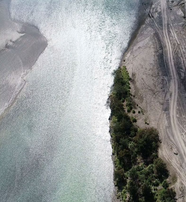
Figure 2-6 Wide, active alluvial surfaces distinguish braided and wandering rivers from more confined/stable me-
andering ones. A riparian buffer (at right) on a large river (Tapuaeroa) can moderate and filter inputs from adjacent
farmland.22 Figure 2-7 Water pathways through
the hyporheic zone in gravel bed
Cross-bank rivers provide linkages for oxygen and
one
flow nutrient flux, which are important for
Riffle stream biota forming the basis of the
c Z
riverine food web. Preferential flow
ei
rh
may occur in abandoned paleochan-
po
nels. Alteration of these pathways
Hy Pool
Paleochannel can impact the potential for ecologi-
cal recovery of the river. After Tonina
and Buffington (2009).
Hyporheic Groundwater
Zone
Sedimentary Strata
distinct from far-field inflow of groundwater and protected and maintained. Gravel stocks, and
from one-way outflow of river water (i.e. flow screening and loading operations should be kept
paths that do not circulate water from the river at a distance from the active alluvial surface, with
and back again). a good buffer of vegetation around the site.
The Riparian Zone Quarry Traffic
The riparian zone is land adjacent to the ac- Hauling many hundreds of thousands of cubic
tive channel. This boundary, a few metres to metres of gravel from the river involves many
hundreds of metres wide, forms a key interface tens of thousands of truck trips, increasing traffic
between river and land that moderates all hydro- on local roads and adding wear to transport
logical, geomorphological, and biological pro- infrastructure. Effects of quarry traffic include
cesses associated with this interconnected fluvial vibration, congestion, safety and noise. Given the
corridor (Gregory et al., 1991). In undisturbed relatively quiet setting of Ruatoria and surround-
environments, it is a zone of high species diver- ing communities, there is potential for these
sity, with a succession of vegetation from pioneer impacts to be significant.
willows to mature forest.
Riparian areas provide a buffer that will Air Quality
• protect banks from erosion and localised
An emerging complaint for residents near the
changes in morphology
river is the entrainment by the wind of dried silt
• moderate the input of nutrients, silt, microbes
that has been layered on the floodplains. During
and pesticides from overland flow
dry spells in late summer, the dust is carried great
• decrease the flow velocity of overbank flood
distances by strong convective winds originating
flows, thus limiting erosive energy.
mainly from the Raukuara Ranges to the north-
• maintain stream temperature and microclimate
west (Figure 2-8a). This effect is strongly exac-
erbated by heavy vehicle traffic over the flood-
The influence of riparian zones on the adjacent
plains, excavation of new material, and dumping
watercourse increases as the width of the river
of excavated material in stockpiles. (Figure
course decreases (Collier et al., 1995), thus small-
2-8b,c). Dust can also arise from dumping, sort-
er streams derive proportionally greater benefits
ing and screening processes at the gravel landings
from healthy riparian areas. That said, for even
next to the river.
the widest alluvial sections of the Waiapu, ri-
parian areas play key ecological, hydrological
and geomorphic roles, and therefore should beKey Messages: 23
• The Waiapu River’s benthic (river bed) environment, and fish/eel populations, have changed
markedly in the last fifty years. Broader ecological recovery in the catchment depends on
rehabilitation of functional river habitat.
• River substrate is important to river biota. Coarse cobble/gravel fractions are important, yet
these are also an attractive target for extraction operations. A balance must be struck, preserving
longitudinal and lateral connectivity of river habitat,
rearing grounds and refugia.
• Connectivity includes subsurface pathways: the integrity
of ‘undergrounds rivers’ and the hyporheic zone within
floodplains should be evaluated when mapping out the
footprint of proposed extraction activities.
• Riparian zones are a vital interface between terrestrial and
riverine habitat and nutrients, and buffer the river system
from erosion. These should be protected and revitalised,
where possible.
• Impacts from extraction include traffic, noise and
exacerbation of air quality issues. These should be
(a)
addressed in consenting conditions.
Meteoblue.com
(b)
(c)
Figure 2-8 - A wind rose diagram (top) shows the predominant wind direction from the NW. Dust clouds billow over
the Waiomatatini Road site in the wake of haulage trucks disturbing dry silty river sediments draped over the bar.
Middle: truck hauling gravel upstream of the SH35 bridge; Bottom: Looking SE from Te Araroa Road (SH35).24
u es En
V al vi
ro
ty n
m
i
un
en
m
t
m
Co
ts
Effec
Pro
ive
tec
at
tiv
ul
e
m
W
Cu
rk
o
s
lo gy
River Mo rpho
2.3 Cumulative Effects
Consenting and allocation of gravel extraction should take careful consideration of
recent and/or ongoing operations both upstream and downstream. A local deficit of ma-
terial, for instance, may form a knickpoint or discontinuity in the river long profile, and
this can travel upstream, steepening the bed and enhancing local erosion of material. Al-
ternately, local shortfalls in gravel supply can cascade downstream, moving as a kinemat-
ic ‘wave’ and enhancing erosion effects downstream (James, 2010). Because of the way
river networks are organised, effects can interact, potentially amplifying the nature of
many smaller perturbations. The impacts of reduced sediment supply may not be evident
for many flood cycles, and indeed, may affect the river long after gravel extraction oper-
ations have ceased (see Martín-Vide et al., 2010). The transit of material is a function of
the channel geometry and the recurrence interval of large floods: in a large catchment
with many tens of kilometres of active channel, it will take some time for any surplus or
shortfall to work through the system.
In this section we consider (1) cumulative temporal effects that can occur from persis-
tent extraction from one point in the river, with consideration of lags and transit times,
and (2) cumulative spatial effects that occur from extracting a multitude of points up-
stream of the river’s main stem (in this case the Waiapu). We first review the types of
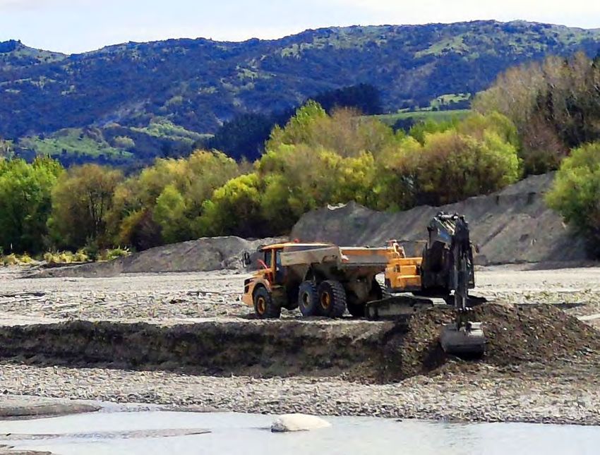
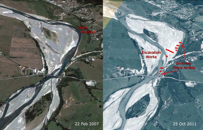
extraction operation currently active in the Waiapu.Gravel Extraction 25
Methods
Extraction within the Waiapu
occurs mainly via one, or some
combination, of the following
techniques, ordered here by the
degree of encroachment upon
the active channel:
(1) In-channel works. Extrac-
tion, screening, stockpiling
all occur within the active
channel.
(2) Excavation within the Figure 2-9 The Aorongiwai Stream (right) has experienced bed degra-
dation (leading to undermining of bridge support), through a combina-
alluvial floodplain (though
tion of gravel extraction and reduced sediment delivery from the upper
not within active channel). catchment.
Stripping (skimming, scalp-
ing) of the active surface
(generally =0.7 m), on the river, roughly 800 m upstream. In-channel
mining of substrate in the active floodplain excavation and stockpiling (Technique 1) oc-
or low terraces. This may occur adjacent to curred around the same time as forestry oper-
the active channel, or closer to the middle of ations in the catchment (ca. 2008-2009). The
the bar. forestry work, and the confined setting resulted
in traffic of machinery and sediment recruitment
(4) Excavation of the floodplain near the active to the channel. The channel course has narrowed,
channel but confined within a gravel berm, straightened and cut down in the years following
designed to keep flowing water out at base- this work (Figure 2-10). This could be attrib-
flow, and provide a spillway for high flows. utable, in part, to the shutdown of a large gully
system 1.4 km upstream. The Aorongiwai bridge
(5) Off-channel excavation of relict floodplains, abutments were subsequently undermined, and
terraces, fans and other deposits. Older the pilings have been exposed (photo was taken
alluvial deposits adjacent to the channel hold in 2016). Tenders for repair of the bridge were
large quantities of river gravel that can be sent out in 2019. A large landslide in the headwa-
accessed without entering the river system. ters that occurred in mid-2020 may change the
trajectory again. The sequence provides a good
Work is generally carried out using excavators, example of the response time (6-7 years), and the
graders and bulldozers. Material is carried away impacts of sediment deficit in a relatively small
in dump trucks. Excavations are typically de- system (~23 km2) where rates of replenishment
signed to ensure no silt laden material escapes are quite variable, and the river may reconfigure
into the active river channel. (Stevens and Lars- itself fairly rapidly in response to supply changes.
en, 2015). Disturbance can be either relatively Similar cases of extraction within smaller catch-
wide and shallow (Technique 1 and 5), or less ments have been reported in Liébault and Piégay
extensive and deep (Technique 2-4). (2001) and Marston et al. (2003).26
Figure 2-10 Aorongiwai River, upstream of the Matahaia Bridge (see Figure 2-9). Flow is left to
right. Gravel operations were carried out in-stream, gravel was stockpiled on the river bed, and
note the absence of barriers between flowing water and active excavation. The example emphasis-
es the capacity for relatively rapid change in sediment supply, even following cessation of gravel
extraction (©Digital Globe, Google Earth).27
Figure 2-12 A bar surface is reconfigured by stripping
Figure 2-12 shows a bar surface reconfigured operations (Technique 2) at a bar head in the Mata
by stripping operations (Technique 2) at a River, near Te Koau. Flow is left to right. ©Digital Globe,
bar head in the Mata River, near Te Koau. The Google Earth, 2019.
depth of disturbance is shallower than deep pit
mining, though the disturbance extends across morphology pre-excavation and consider how
a much broader portion of the riverbed for a best to work with the river to maintain a func-
given volume of yield. The upstream ‘head’ of the tional morphology, grain size distribution and
bar has been targeted for the relatively coarser sediment transport regime.
gravels that can be found there (cf. Section 2.4).
This is an area of high flow attack and thus it is The depth of pit excavations also requires some
usually relatively 'armoured' with coarse gravels consideration. Once a deep pit is excavated
and cobbles (Collins and Dunne, 1990; Rinaldi et within the channel, the profile of the streambed
al., 2005). Given the confined setting on the Mata is no longer in equilibrium with the sediment
River, most of this site will be inundated and load from upstream. The channel form must
the bar surface reworked in the next large flood. re-grade itself to maintain a continuous gradient;
The biased removal of coarser and more durable the steep slope at the upstream end of the pit
material (thereby enriching fine material) can accelerates erosion there, resulting in knickpoint
lead to morphological changes in the reach over retreat (Figure 2-11). The pit fills with the eroded
time. sediment, and material is eroded from the bed
downstream. This effect can extend for hundreds
The technique of bar-edge scalping, downstream of metres, to kilometres upstream, depending
from the bar head (lower two-thirds of the bar) on the volume excavated from the bed and rates
along the margin of the active channel has been of bedload replenishment from upstream (see
recommended as a better (if experimental, thus Kondolf, 1997).
far) approach (Church et al.,
2001), as it maintains channel con- Le vel
Water
veyance and minimises impacts to
Bed
channel stability and morphology. l River
Origina
Excavation work plans should take "Knickpoint"
care to document the prevailing avatio n
Bed Exc
Figure 2-11 Conceptual diagram
showing the effects of deep pit
excavation within a riverbed (dia-
gram adapted from Kondolf (1994)).
The scale and proportions of these Pit Filling Knickpoint
erosional effects will vary, depend- Retreat
ing on river scale, sediment supply,
and other hydraulic and sedimentary Bed
factors. Lowering28 Multiple Operations in Space for the contractor, although the Council re-
Gravel supply conditions will vary throughout serves the right to modify operations if there are
the catchment, and it is therefore important to signs of riverbed degradation. Current levels of
take into consideration how the system may extraction would allow a maximum of 450 000
respond to surplus or deficit within the many m3 (~720 000 t) to be removed from rivers in
network linkages of the system. Over-extraction the catchment every year. Consented operations
at any given point in the network can lead to have grown significantly since the early 2000s
knickpoint development (Kondolf, 1994; Wis- when commercial operations on the Waiapu and
hart et al., 2008), and may also induces shortages Mata first got underway (Figure 2-13b).
downstream that can lead to enhanced erosion,
for instance, via lateral bank erosion (Liébault By way of comparison, the Ngaruroro River in
and Piégay, 2001). A river flowing at a given dis- Hawkes Bay (2 010 km2), the most heavily ex-
charge and slope needs to satisfy its equilibrium tracted system on the North Island’s East Coast,
sediment concentration; a river starved of supply has reduced extraction rates from an average
from upstream will adopt a “hungry water” dis- of 300 000 m3∙yr-1, since 2013 (Clode and Beya,
position (Kondolf, 1997), satisfying the shortage 2018). Gravel takes from the Waimakariri (3 110
through lateral erosion of the floodplains and/or km2) from 1993-2003 are variable, but on the
the river bed. order of 320 000 m3∙yr-1, according to Hudson
(2005). Current rates in the Waiapu are thus
At the time of writing, least four contracting high, for a river catchment of its size, and the
operations are currently working in the catch- accelerating rate over time is notable.
ment (Figure 2-13). Consenting agreements are
set for about 8 years, on average, allowing for Transport costs figure significantly into the
some measure of economic certainty on returns profitability of gravel extraction. Sites that are
(a)
(b)
Figure 2-13 Extraction timeline for the Tapuaeroa, Mangaoporo, Mata and Waiapu Rivers.
Conditions and agreements in place as of February 2020.You can also read