ARSENAL LANDS MASTER PLAN ADDENDUM - INCLUDING MARIE CURTIS PARK WEST
←
→
Page content transcription
If your browser does not render page correctly, please read the page content below

Arsenal Lands
Master plan addendum
       Including marie curtis park west

                        November, 2007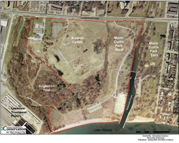
© T o r o n t o a n d  R e g i o n  C o n s e r v a t i o n
2 0 0 7

www.trca.on.ca

5 Shoreham Drive,
Toronto, Ontario  M3N 1S4

phone: 416-661-6600
fax: 416-661-6898
ACKNOWLEDGMENTS

Hendrik Amo       Adriana Gomez      Mark Preston
Roy Averill       Sean Harvey        Rick Reitmeier
Bruce Carr        Dave Hatton        Lorenzo Ruffini
Deanna Cheriton   Natalie Iwanycki   Gary Short
Sharon Chapman    Randy Jamieson     Laura Stephenson
Mike Fenning      David Lawrie       Paul Taylor
Larry Field       Alex Phillips      Ralph Toninger
EXECUTIVE SUMMARY 3.0 MASTER PLAN ADDENDUM
The Master Plan Addendum is consistent with the goals and objectives of the original Master Plan
released in 1998. The Addendum reinforces the original intent of the partners to form a regional
1.0 INTRODUCTION waterfront park that offers recreation opportunities for Mississauga and Toronto residents. The
park plan is inspired by the unique natural and historical features of the parkland and is intended
The Arsenal Lands is a 15.7-hectare property located south of Lakeshore Road East on the eastern
to be conceptual. The exact size and location of the proposed park features will be determined
border of the City of Mississauga. In October 1992, Toronto and Region Conservation (TRCA)
during the detailed design process that will involve further public consultation.
purchased the property with the intent of expanding Marie Curtis Park to form a 41-hectare
waterfront park.
The Addendum builds on the original Master Plan by offering not only trails and picnicking venues
but also complimentary park facilities to make the park experience more enjoyable and attractive to
Shortly after the property was purchased, TRCA retained a consulting consortium to undertake a
potential users. These complimentary facilities include a new play area, a splash pad, washrooms,
park planning and site remediation study. The purpose of the study was to determine the nature
and a “leash-free” area for dog owners. The additional park facilities have been selected to meet
and extent of contaminants on site, identify methods of rehabilitating the lands to permit public
public demand and have been sited to help deter inappropriate park use in underused areas. The
use and develop innovative ideas for the incorporation of the site as a major regional attraction on
Addendum outlines the plans to preserve historic features, protect and enhance natural heritage
the Lake Ontario waterfront.
resources, and develop new park features and amenities.
The Arsenal Lands Park and Site Remediation Master Plan was released in 1998. The Plan included
recommendations for site remediation to achieve park use guidelines and a park concept based on a 4.0 DESIGN GUILDINES
conservative landscape rehabilitation approach. INTERA was retained by TRCA to implement the The use of new technologies and materials will be explored to create an environmentally friendly
remediation plan that was concluded in 2002. park. The focus will be on the park’s unique natural features. These natural features will dictate
the precise siting of park infrastructure and facilities during the detailed design process.
In 2003, with the assistance of a Technical Steering Committee, TRCA identified several issues
requiring further assessment and resolution before park development could proceed. The Arsenal 5.0 MANAGEMENT PLAN
Lands Master Plan Addendum including Marie Curtis Park West was prepared to provide a clear direction
for the park and ensure that the overall park concept reflects the current site conditions and the Under the umbrella of TRCA’s management agreement with the City of Mississauga, municipal
needs of the community. staff will carry out the day-to-day operations of the park. The City of Mississauga has a
comprehensive system of best environmental management policies in place to direct the
overall maintenance of these lands. To ensure that the park operations are consistent with the
2.0 EXISTING CONDITIONS
recommendations of the Addendum, an overall management approach has been developed.
The Arsenal Lands were formerly used for industrial purposes, most notably as a manufacturing site
for small arms during the Second World War. Site remediation was undertaken between 1998 and 6.0 PUBLIC CONSULTATION
2002, and included extensive soil excavation that presented the opportunity to create new landforms
and improve the natural integrity of the site. Public consultation was undertaken by TRCA in 2005 and included a questionnaire asking
potential park users to identify recreational activities and park amenities that they felt should be
A diversity of habitats are represented at the Arsenal Lands and Marie Curtis Park West including available at the Arsenal Lands. Of all the recreation activities offered, hiking/walking, picnicking
beach, woodland, wetland, meadow and riparian habitats. This habitat diversity gives rise to the and children’s play were identified as key priorities. Of the park amenities offered, washrooms,
presence of numerous notable flora and fauna species. seating and drinking fountains were identified as key priorities.
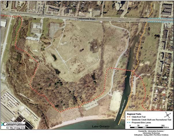
The Waterfront Trail and the Etobicoke Creek Multi-use Recreational Trail connect the Arsenal 7.0 APPROVALS
Lands and Marie Curtis Park West with surrounding greenspaces. There is also a network of Adoption of the Master Plan Addendum will be subject to the approval of TRCA, Mississauga
informal trails throughout these parks. Site services within the Arsenal Lands were decommissioned Council, Toronto Council and Region of Peel Council. Additional approvals may be required for
during the site remediation process, however a number of facilities exist within Marie Curtis Park implementation of individual components of the Addendum, particularly those that may affect
West. lands adjacent to Lake Ontario or Etobicoke Creek.
II III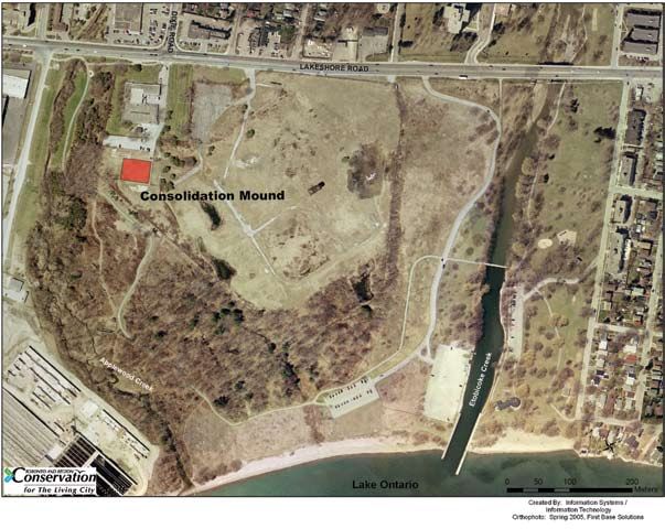
8.0     IMPLEMENTATION                                                                                          TABLE OF CONTENTS
Master Plan implementation will involve construction of the main park infrastructure and
associated servicing, which includes trails, roads, parking lots and washrooms. Peripheral items
such as landscaping and habitat improvements will be implemented based on funding availability.    1.0	INTRODUCTION . . . . . . . . . . . . . . . . . . . . . . . . . . . . . . . . . . . . . . . . . . . . . . . . . . . . . . . . . . . . . . . . . .  1
                                                                                                        1.1 Purpose of the Addendum . . . . . . . . . . . . . . . . . . . . . . . . . . . . . . . . . . . . . . . . . . . . . . . . . . . . . . .  3
9.0     CAPITAL COSTS                                                                                   1.2 Context of the Addendum . . . . . . . . . . . . . . . . . . . . . . . . . . . . . . . . . . . . . . . . . . . . . . . . . . . . . . .  4

The capital costs for park development are estimated at $3,000,000 for the Arsenal Lands and
                                                                                                   2.0         EXISTING CONDITIONS  . . . . . . . . . . . . . . . . . . . . . . . . . . . . . . . . . . . . . . . . . . . . . . . . . . . . . . . . . 16
$1,000,000 for Marie Curtis Park West (based on 2005 dollars).
                                                                                                               2.1 Site Remediation . . . . . . . . . . . . . . . . . . . . . . . . . . . . . . . . . . . . . . . . . . . . . . . . . . . . . . . . . . . . . . . 17
                                                                                                               2.2 Natural Heritage . . . . . . . . . . . . . . . . . . . . . . . . . . . . . . . . . . . . . . . . . . . . . . . . . . . . . . . . . . . . . . . 18
10.0    FUNDING                                                                                                2.3 Etobicoke Creek  . . . . . . . . . . . . . . . . . . . . . . . . . . . . . . . . . . . . . . . . . . . . . . . . . . . . . . . . . . . . . . . 20
Park development will be funded through savings from the initial site remediation budget and                   2.4 Cultural Heritage . . . . . . . . . . . . . . . . . . . . . . . . . . . . . . . . . . . . . . . . . . . . . . . . . . . . . . . . . . . . . . 20
through TRCA, City of Toronto and City of Mississauga capital budgets. Fundraising will also be                2.5 Trails  . . . . . . . . . . . . . . . . . . . . . . . . . . . . . . . . . . . . . . . . . . . . . . . . . . . . . . . . . . . . . . . . . . . . . . . . . 22
undertaken by TRCA to offset park development costs.                                                           2.6 Site Servicing and Infrastructure . . . . . . . . . . . . . . . . . . . . . . . . . . . . . . . . . . . . . . . . . . . . . . . . 23
                                                                                                               2.7 Demographics . . . . . . . . . . . . . . . . . . . . . . . . . . . . . . . . . . . . . . . . . . . . . . . . . . . . . . . . . . . . . . . . . 24

                                                                                                   3.0         MASTER PLAN ADDENDUM . . . . . . . . . . . . . . . . . . . . . . . . . . . . . . . . . . . . . . . . . . . . . . . . . . . . . . 25
                                                                                                               3.1 Guiding Principles . . . . . . . . . . . . . . . . . . . . . . . . . . . . . . . . . . . . . . . . . . . . . . . . . . . . . . . . . . . . . 25
                                                                                                               3.2 Summary of Changes to the Master Plan . . . . . . . . . . . . . . . . . . . . . . . . . . . . . . . . . . . . . . . . .27
                                                                                                               3.3 Art and Cultural Heritage Features . . . . . . . . . . . . . . . . . . . . . . . . . . . . . . . . . . . . . . . . . . . . . . 30
                                                                                                               3.4 Natural Heritage Protection and Enhancement . . . . . . . . . . . . . . . . . . . . . . . . . . . . . . . . . . . 31
                                                                                                               3.5 Park Features . . . . . . . . . . . . . . . . . . . . . . . . . . . . . . . . . . . . . . . . . . . . . . . . . . . . . . . . . . . . . . . . . . 38
                                                                                                               3.6 Park Amenities  . . . . . . . . . . . . . . . . . . . . . . . . . . . . . . . . . . . . . . . . . . . . . . . . . . . . . . . . . . . . . . . . 44
                                                                                                               3.7 Safety . . . . . . . . . . . . . . . . . . . . . . . . . . . . . . . . . . . . . . . . . . . . . . . . . . . . . . . . . . . . . . . . . . . . . . . . . 47
                                                                                                               3.8 Signs . . . . . . . . . . . . . . . . . . . . . . . . . . . . . . . . . . . . . . . . . . . . . . . . . . . . . . . . . . . . . . . . . . . . . . . . . . 48
                                                                                                               3.9 Education and Stewardship . . . . . . . . . . . . . . . . . . . . . . . . . . . . . . . . . . . . . . . . . . . . . . . . . . . . . 48

                                                                                                   4.0         DESIGN GUIDELINES  . . . . . . . . . . . . . . . . . . . . . . . . . . . . . . . . . . . . . . . . . . . . . . . . . . . . . . . . . . . . 49

                                                                                                   5.0         MANAGEMENT PLAN  . . . . . . . . . . . . . . . . . . . . . . . . . . . . . . . . . . . . . . . . . . . . . . . . . . . . . . . . . . . . 51
                                                                                                               5.1 Natural Environment  . . . . . . . . . . . . . . . . . . . . . . . . . . . . . . . . . . . . . . . . . . . . . . . . . . . . . . . . . . 53
                                                                                                               5.2 Primary Restoration . . . . . . . . . . . . . . . . . . . . . . . . . . . . . . . . . . . . . . . . . . . . . . . . . . . . . . . . . . . . 53
                                                                                                               5.3 Secondary Restoration  . . . . . . . . . . . . . . . . . . . . . . . . . . . . . . . . . . . . . . . . . . . . . . . . . . . . . . . . . 54
                                                                                                               5.4 Public Use . . . . . . . . . . . . . . . . . . . . . . . . . . . . . . . . . . . . . . . . . . . . . . . . . . . . . . . . . . . . . . . . . . . . . 54
                                                                                                               5.5 Lease Zone  . . . . . . . . . . . . . . . . . . . . . . . . . . . . . . . . . . . . . . . . . . . . . . . . . . . . . . . . . . . . . . . . . . . . 54
                                                                                                               5.6 Restricted Access Zone  . . . . . . . . . . . . . . . . . . . . . . . . . . . . . . . . . . . . . . . . . . . . . . . . . . . . . . . . . 54
                                                                                                               5.7 Canada Goose Management . . . . . . . . . . . . . . . . . . . . . . . . . . . . . . . . . . . . . . . . . . . . . . . . . . . . 54
                                                                                                               5.8 West Nile Virus . . . . . . . . . . . . . . . . . . . . . . . . . . . . . . . . . . . . . . . . . . . . . . . . . . . . . . . . . . . . . . . . 55

                                                                                                   6.0         PUBLIC CONSULTATION . . . . . . . . . . . . . . . . . . . . . . . . . . . . . . . . . . . . . . . . . . . . . . . . . . . . . . . . . 56

                                                                                                   7.0         APPROVALS . . . . . . . . . . . . . . . . . . . . . . . . . . . . . . . . . . . . . . . . . . . . . . . . . . . . . . . . . . . . . . . . . . . . . . .58
                                                                                                               7.1 Environmental Assessment Act . . . . . . . . . . . . . . . . . . . . . . . . . . . . . . . . . . . . . . . . . . . . . . . . . . 58

IV 
7.2 Region of Peel . . . . . . . . . . . . . . . . . . . . . . . . . . . . . . . . . . . . . . . . . . . . . . . . . . . . . . . . . . . . . . . . . . . . . 59 APPENDICES
7.3 City of Mississauga . . . . . . . . . . . . . . . . . . . . . . . . . . . . . . . . . . . . . . . . . . . . . . . . . . . . . . . . . . . . . 59 Appendix A - Record of Flora and Fauna . . . . . . . . . . . . . . . . . . . . . . . . . . . . . . . . . . . . . . . . . . . . . 67
7.4 City of Toronto . . . . . . . . . . . . . . . . . . . . . . . . . . . . . . . . . . . . . . . . . . . . . . . . . . . . . . . . . . . . . . . . . . . . 59 Appendix B - Record of Fish Species Found in Lower Etobicoke Creek . . . . . . . . . . . . . . . . . 73
7.5 Toronto and Region Conservation . . . . . . . . . . . . . . . . . . . . . . . . . . . . . . . . . . . . . . . . . . . . . . 59 Appendix C - Cultural Heritage . . . . . . . . . . . . . . . . . . . . . . . . . . . . . . . . . . . . . . . . . . . . . . . . . . . . . 75
Appendix D - Summary of 2005 Public Comments . . . . . . . . . . . . . . . . . . . . . . . . . . . . . . . . . . . 77
8.0 IMPLEMENTATION . . . . . . . . . . . . . . . . . . . . . . . . . . . . . . . . . . . . . . . . . . . . . . . . . . . . . . . . . . . . . . . 60
9.0 CAPITAL COSTS . . . . . . . . . . . . . . . . . . . . . . . . . . . . . . . . . . . . . . . . . . . . . . . . . . . . . . . . . . . . . . . . . . 61
10.0 FUNDING . . . . . . . . . . . . . . . . . . . . . . . . . . . . . . . . . . . . . . . . . . . . . . . . . . . . . . . . . . . . . . . . . . . . . . . . 62
11.0 REFERENCES . . . . . . . . . . . . . . . . . . . . . . . . . . . . . . . . . . . . . . . . . . . . . . . . . . . . . . . . . . . . . . . . . . . . . 63
LIST OF FIGURES
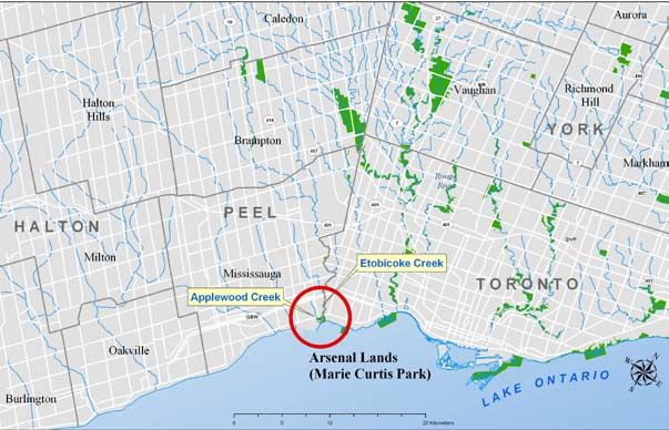
Figure 1. Location of the Arsenal Lands. . . . . . . . . . . . . . . . . . . . . . . . . . . . . . . . . . . . . . . . . . . . . . . . . . . . 2
Figure 2. Current park boundaries, jurisdiction and land ownership. . . . . . . . . . . . . . . . . . . . . . . . . . 3
Figure 3. The Arsenal Lands and Marie Curtis Park West park boundary. . . . . . . . . . . . . . . . . . . . . 16
Figure 4. Location of Consolidation Mound. . . . . . . . . . . . . . . . . . . . . . . . . . . . . . . . . . . . . . . . . . . . . . . 18
Figure 5. Monarch butterflies feeding on asters during fall migration. . . . . . . . . . . . . . . . . . . . . . . 19
Figure 6. The Arsenal Lands in 1949. . . . . . . . . . . . . . . . . . . . . . . . . . . . . . . . . . . . . . . . . . . . . . . . . . . . . . 21
Figure 7. Regional trail connections. . . . . . . . . . . . . . . . . . . . . . . . . . . . . . . . . . . . . . . . . . . . . . . . . . . . . . . 23
Figure 8. The Arsenal Lands/Marie Curtis Park West conceptual park plan. . . . . . . . . . . . . . . . . . . 28
Figure 9. The Arsenal Lands water tower, built in 1941. . . . . . . . . . . . . . . . . . . . . . . . . . . . . . . . . . . . . 30
Figure 10. Recommended Ecological Function Zone and 50-metre wetland buffer. . . . . . . . . 32
Figure 11. Example of backshore dune restoration planned for Marie Curtis Park West. . . . . . . . 34
Figure 12. Meadows will be managed to provide habitat for species such as butterflies. . . . . . . . . 35
Figure 13. Stone estuary hooks are proposed to improve in-stream fish habitat. . . . . . . . . . . . . . . . 36
Figure 14. Extensive creek-side planting will improve water quality and habitat. . . . . . . . . . . . . . . . 37
Figure 15. The Common will provide open space for events or informal recreation. . . . . . . . . . . . . 39
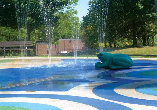
Figure 16. Wetland-themed splash pad at Forest Glen in Mississauga. . . . . . . . . . . . . . . . . . . . . . . . . 40
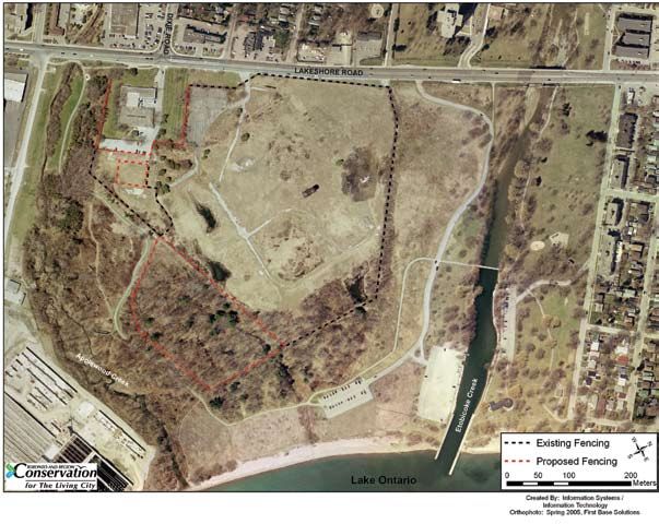
Figure 17. Current and proposed locations of fencing. . . . . . . . . . . . . . . . . . . . . . . . . . . . . . . . . . . . . . . 47
Figure 18. Designated park management zones. . . . . . . . . . . . . . . . . . . . . . . . . . . . . . . . . . . . . . . . . . . . . 51
LIST OF TABLES
Table 1. Goals and objectives summary. . . . . . . . . . . . . . . . . . . . . . . . . . . . . . . . . . . . . . . . . . . . . . . . . . . 26
Table 2. Permitted resource uses by management zone. . . . . . . . . . . . . . . . . . . . . . . . . . . . . . . . . . . . 52
Table 3. Estimates based on conceptual park plan in 2005 dollars. . . . . . . . . . . . . . . . . . . . . . . . . . 61
II III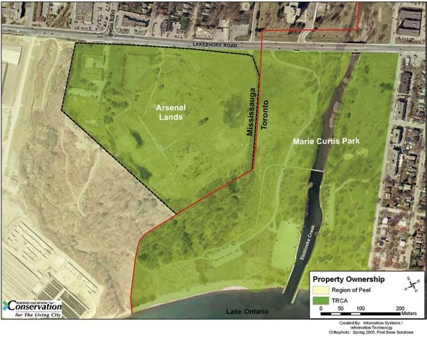
C    H       A   P   T    E    R

                                                  1
1.0 INTRODUCTION

The Arsenal Lands is a 15.7-hectare property located south of Lakeshore Road East on the eastern
border of the City of Mississauga. In October 1992, Toronto and Region Conservation (TRCA)
purchased the property with the intent of expanding Marie Curtis Park to form a 41-hectare,
waterfront park. The land purchase was made possible through a joint collaboration involving
City of Toronto, Region of Peel, City of Mississauga and the Province of Ontario. As part of the
agreement of purchase, TRCA and the former landowner (Canada Post) each contributed $2.5
million to remediate the site.

Shortly after the property was purchased, TRCA retained a consulting consortium (consisting of
Hough Woodland Naylor Dance Leinster, Raven Beck Environmental Limited, Duke Engineering
and Services Inc., Angus Environmental Ltd., Michael Michalski Associates and DS Lea Associates) to
undertake a park planning and site remediation study. The purpose of this study was to determine
the nature and extent of contaminants on the site, identify methods of rehabilitating the lands to
permit public use, and develop innovative ideas for the incorporation of the site as a major regional
attraction on the Lake Ontario waterfront. The consultant team reported to a Technical Steering
Committee consisting of staff from TRCA, the City of Toronto, the City of Mississauga and the
Region of Peel to ensure that the interests of the public and participating agencies were addressed.

The consulting consortium released the first in a series of three newsletters in May 1995.
Approximately 1,000 community stakeholders, including more than 100 interest groups, received
the newsletters. Two public open houses were also held to discuss the development of the Master
Plan and receive public input in 1995. The results of the public consultation were utilized to direct
the site remediation approach and design of the park concept.

The Arsenal Lands Park and Site Remediation Master Plan was released in 1998. The Plan included
recommendations for site remediation to achieve the park use guidelines established by the
Province, a long-term monitoring plan and a park concept based on a conservative landscape
rehabilitation approach. The focus of the Plan was the rehabilitation of the Arsenal Lands property
and the provision of minimal park facilities. The Plan also made recommendations to integrate the        resolution before park development could proceed. Some of these issues included:
Arsenal Lands with the Waterfront Trail and Marie Curtis Park.
                                                                                                             w    Change in site conditions.
In September 1998, the Authority provided direction to implement the site remediation plan. Toronto          w    Current needs of the community.
and Region Conservation proceeded to retain INTERA (formerly Duke Engineering and Services)                  w    Need for a long-term park program and management strategy.
to coordinate remediation of the site, which involved the removal of more than 70,000 tonnes of soil         w    Safety concerns associated with inappropriate park use in remote areas.
from the site and construction of a containment facility for low-level radioactive waste. The site was       w    Potential user conflict associated with the proposed layout of the access road.
remediated at a cost savings of $1,615,982. Canada Post agreed with TRCA to contribute half of the           w    Park facilities to service demand for corporate and large group picnics.
savings from the site remediation budget to finance park development and the implementation of an            w    Park features to draw regional users.
environmental monitoring program. The environmental monitoring program was initiated in 2001
to monitor surface water, groundwater, gamma radiation and radon gas. In 2002, TRCA submitted            These issues provided the rationale for TRCA to spearhead the development of a Master Plan
the Record of Site Condition for the Arsenal Lands property, completed by INTERA Engineering             Addendum.
Ltd. The acknowledged Record of Site Condition was received from the Ontario Ministry of the
Environment (MOE) Halton Peel District Office on November 13, 2002.
                                                                                                         1 . 1 P urpose of t h e  A ddendum
In the spring of 2003, TRCA reconvened a meeting of the Technical Steering Committee to review
the progress made during the site remediation phase and to revisit the original Master Plan. This        The Arsenal Lands Master Plan Addendum including Marie Curtis Park West is an update of The Arsenal
Technical Steering Committee included City of Toronto, City of Mississauga, Region of Peel and           Lands Park and Site Remediation Master Plan (1998). The purpose of the Addendum is to provide
TRCA. The Steering Committee identified several issues that required further assessment and              an overall plan, which: reflects the current site conditions, meets the needs of regional and local park

Figure 1.  Location of the Arsenal Lands.

                                                                                                         Figure 2.  Current park boundaries, jurisdiction and land ownership.

users, addresses potential and existing safety concerns, and provides specific recommendations to direct       w Regional biodiversity — To protect and restore a regional system of natural areas that
park management and operation. Consistent with the 1998 Master Plan, the Addendum integrates the                   provide habitat for plant and animal species, improve air quality and provide opportunities
Arsenal Lands with Marie Curtis Park. The scope of the Addendum however is more clearly defined to                 for the enjoyment of nature.
include specific recommendations for the Arsenal Lands property and the portion of Marie Curtis Park           w   Sustainable communities — To facilitate broad community understanding, dialogue and
located on the west side of Etobicoke Creek (referred to as Marie Curtis Park West).                               action toward integrated approaches to sustainable living and city building that improve
                                                                                                                   the quality of life for residents, businesses and nature.
The portion of Marie Curtis Park located to the east of Etobicoke Creek will be the subject of a               w   Business excellence — To produce continuous improvement in the development and
future park planning process, with the intent that this parkland will continue to be operated by the               delivery of all programs through creative partnerships, diverse funding sources, and careful
City of Toronto to support local recreational use. The City of Toronto and TRCA will prepare a                     auditing of outcomes and effectiveness.
Master Plan Update for Marie Curtis Park East, ensuring that recreational uses and activities are co-
ordinated between the parks. This Master Plan Update will include further public consultation and
require council approval.                                                                                  1 . 2 . 1 . 2 L ake  O ntario  W aterfront
                                                                                                                         D evelopment  P rogram

1 . 2 C ontext of t h e  A ddendum                                                                         Toronto and Region Conservation’s Lake Ontario Waterfront Development Program (1980)
                                                                                                           recognizes the Lake Ontario shoreline as one of the major natural resources of the region. The
The development of the Arsenal Lands and Marie Curtis Park West is a partnership project of City           major areas of concern related to this program are conservation, restoration, development and
of Toronto, City of Mississauga, TRCA and Region of Peel. As the property owner, TRCA has taken            management of waterfront resources and the protection and management of important natural
the lead in developing the Master Plan Addendum. The mandate of TRCA and the project partners              habitats. The Lake Ontario Waterfront Development Program objectives include:
is reflected in the Addendum.
                                                                                                               w Acquiring land for open space.
                                                                                                               w	Incorporating public recreational use.
1 . 2 . 1 T oronto and  R egion  C onservation
                                                                                                               w Linking waterfront open space with river valley corridors.
                                                                                                               w Creating fishing opportunities via habitat enhancement.
At meeting #3/91 on May 3, 1991, TRCA staff were directed by the Authority to proceed with the                 w Providing safe harbourage for the boating public.
acquisition and upon closing the transaction, coordinate a detailed planning study with Toronto,               w Preserving lower valley marsh areas.
Peel, Mississauga, the province and individuals and groups with interest in the site. On September             w Co-operating with agencies undertaking waterfront planning and development.
25, 1998, at Authority Meeting #8/98, staff were directed to implement the site remediation plan               w Furthering research of lake processes.
as per the Arsenal Lands Site Remediation Plan and Park Master Plan and that this Plan be circulated to        w Co-operating with agencies concerned with improving the water quality of Lake Ontario.
the partners for comment and approval.
                                                                                                           This Program identified Marie Curtis Park as a major regional waterfront park and recommended
                                                                                                           the purchase of the Arsenal Lands for the purpose of park expansion.
1 . 2 . 1 . 1 T owards a  L iving  C ity  R egion

Toronto and Region Conservation is committed to community partnerships with all sectors                    1 . 2 . 1 . 3 S h oreline  M anagement  P rogram
of society, to encourage environmental stewardship and build on innovative thinking about
environmental health, social responsibility and sustainable economies.                                     Toronto and Region Conservation’s Shoreline Management Program (1980) is a comprehensive
                                                                                                           approach to shoreline management which respects the natural attributes of the Lake Ontario
Toronto and Region Conservation’s vision of a Living City Region has four objectives:                      waterfront. This program recognizes the development pressures arising out of the public’s interest
                                                                                                           to live on the waterfront. The focus of the program is on preventing the potential hazard to
    w Healthy rivers and shorelines — To restore the integrity and health of the region’s rivers           development located in areas vulnerable to the effects of flooding and erosion. Understanding the
        and waters from the headwaters in the Oak Ridges Moraine, throughout each of the nine              need for some shoreline modifications in order to minimize the loss of property, various alternative
        watersheds in TRCA’s jurisdiction, to the Toronto waterfront on Lake Ontario.                      shoreline management measures are outlined to ensure that the appropriate treatment is used
to balance natural coastal processes with public demand for open space and intensive waterfront               w Complete management plans for all TRCA-owned lands within the target system.
development.                                                                                                  w Develop natural heritage restoration plans for all lands that are potential natural cover.
                                                                                                              w Where municipalities manage TRCA-owned lands, TRCA will work with them to ensure the
                                                                                                                  management agreement is in accordance with the Strategy.
1 . 2 . 1 . 4 T oronto  W aterfront  A q uatic
                                                                                                              w   Provide opportunities for appropriate passive recreation within the target system.
              Habitat  R estoration  S trategy

The Toronto Waterfront Aquatic Habitat Restoration Strategy (2003) was developed by TRCA to               1 . 2 . 1 . 6 V alley and  S tream  C orridor
ensure that the revitalization of the waterfront incorporates improvements to aquatic habitats                          M anagement  P rogram
as an integral part of creating a more livable and sustainable waterfront. The overall goal of
the Strategy is “to maximize the potential ecological integrity of the Toronto waterfront.” This          The Valley and Stream Corridor Management Program (1994) is a guideline document developed
Strategy identifies the potential for self-sustaining aquatic communities in open coast, sheltered        by TRCA to direct landuse activities and development within valley and stream corridors. This
embayments, coastal wetlands and estuaries. It also identifies limiting factors and evaluates             program acknowledges the need for risk management related to flooding, erosion and slope
opportunities to protect and enhance near-shore habitats. Finally, the Strategy offers an                 instability, while ensuring that future environmental degradation is prevented and natural areas are
implementation plan and framework to restore aquatic habitats on the Toronto waterfront.                  restored.

The Strategy identifies several recommendations for the Etobicoke Creek estuary and adjacent              This program includes policies and criteria that govern any change to existing resource-based
waterfront. Within the Etobicoke Creek estuary, the Strategy suggests that structural habitat             uses of valley and stream corridors, relevant to Marie Curtis Park West. The Program also offers
be reintroduced and that riparian vegetation be restored to reflect historic conditions. On the           recommendations for the rehabilitation of valley and stream corridors that will help direct short
shoreline, the Strategy recommends that offshore points and shoals, and a wetland be constructed          and long-term resource planning activities.
to improve habitat for desirable fish species.

                                                                                                          1 . 2 . 1 . 7 E tobicoke  C reek  F is h eries
1 . 2 . 1 . 5 T errestrial  N atural Heritage                                                                           M anagement  P lan
              S ystem  S trategy  ( T N H S S )
                                                                                                          The Etobicoke Creek Fisheries Management Plan (2003) was developed by TRCA to enable work in
Toronto and Region Conservation’s Terrestrial Natural Heritage System Strategy (2006) was designed to     partnership with other agencies, non-government organizations and the public, to protect and
enhance biodiversity and the quality of life for residents by seeking to increase the amount of forest    enhance aquatic habitats within the watershed. The Fish Management Plan is a watershed resource
and wetland habitats. It uses a science-based analytical tool, based on ecological criteria to identify   document that provides background information about the fish community and the physical
an expanded and targeted land base for inclusion in a terrestrial natural heritage system. The            conditions, sets management direction for the future, and provides direction for the development
Strategy was designed for the entire TRCA jurisdiction as terrestrial systems and their interactions      and implementation of rehabilitation projects and monitoring needs. The Plan will also be used as
span watershed boundaries. The target system relates to the terrestrial component of the natural          a tool in the planning and permitting process relevant to Marie Curtis Park West.
heritage system. Although increases in natural cover benefits many other system components, such
as promoting natural water budget, the target terrestrial natural heritage system was designed using
terrestrial ecological criteria. The Strategy contains a number of strategic directions including         1 . 2 . 1 . 8 G reening  O ur  W aters h eds
proposed land use planning policies, land management, stewardship and education opportunities,
and long-term monitoring. For the Etobicoke Creek watershed, the Strategy has set a goal of at            In 1999, TRCA created the Etobicoke and Mimico Creeks Watersheds Task Force with the mandate
least 11per cent natural cover, composed of forest and wetland habitats.                                  to develop an ecosystem-based management strategy to help restore Etobicoke and Mimico
                                                                                                          creeks. Planners, biologists, engineers, heritage preservationists, naturalists, municipal-elected
The Arsenal Lands and Marie Curtis Park West are identified as part of the targeted natural               representatives and watershed residents, were represented in this multi-stakeholder group. In 2002,
heritage system. The Strategy offers specific recommendations for public lands that are identified        the Etobicoke and Mimico Creeks Watershed Plan, entitled Greening Our Watersheds was released.
as part of the target system. The recommendations for public land management, pertinent to this           This Plan was written to assist the people who can make a difference in the watersheds, including
site include:                                                                                             residents, community, business and environmental advocates and leaders, educators, elected
representatives and staff at the federal, provincial, regional and local levels of government. The     development, operation and maintenance of the site. This funding was conditional upon the
Plan details objectives, targets and actions for the revitalization of Etobicoke and Mimico creeks     restrictions on use of such property for passive open space and parkland, ancillary uses only.
watersheds. This Plan will be updated in 2007, 2013 and 2026, and report cards will be prepared
every three years.
                                                                                                       1 . 2 . 2 . 1 T oronto  O fficial  P lan
In 2006 the first Report Card for the Etobicoke and Mimico creeks watersheds was prepared to
assess the state of the watersheds. The Report Card provided a summary of progress made towards        The City of Toronto published the Toronto Official Plan in November 2002. Among the objectives
meeting the goal and objectives for the watersheds and identified future targets for 25 indicators     outlined in the Plan, the city recognizes the importance of clean air, land and water, green spaces,
of watershed health. A number of watershed priorities identified within this report are of relevance   a diversity of recreational opportunities and a spectacular waterfront. The vision of the Plan is to
to the future development and operation of the Arsenal Lands and Marie Curtis Park West. This          create a safe and attractive city that includes clean air, land and water; green spaces; a wealth of
includes the following targets that have been set for 2025:                                            recreational opportunities and a spectacular waterfront. The foundation of the Plan is built on
                                                                                                       diversity and opportunities, beauty, connectivity, and leadership and stewardship.
    w The overall extent of natural cover within the watershed will be increased from 5.47 per
        cent to 11 per cent.                                                                           The Plan includes several policies relevant to green spaces and the waterfront, the public realm, and
    w   The quality of terrestrial natural heritage within the watershed will be ranked as good or     parks and open spaces that have been considered as part of the Master Plan process.
        fair.
    w   The overall quality of aquatic habitats within the watershed will be maintained.
                                                                                                       1 . 2 . 2 . 2 O ur  C ommon  G rounds
    w   Overall riparian cover will be increased from 38.55 per cent to 75 per cent.

                                                                                                       Our Common Grounds was approved as the Strategic Plan for City of Toronto, Parks and Recreation
1 . 2 . 1 . 9 S tate of t h e  E nvironment                                                            in 2004. The Plan identifies the interest of the City of Toronto in enhancing the quality of life in
              R eport                                                                                  the city, through Parks and Recreation's commitment to environmental stewardship, development
                                                                                                       of children and youth, and promotion of lifelong activity for all residents. The vision set forth in
In December 1998, TRCA completed State of the Environment Report: Etobicoke and Mimico Creeks to       the plan is that Toronto will come to be known as “The City within a Park.” Parks and Recreation
support the development of a watershed management strategy. Utilizing an ecosystem approach,           will achieve this vision by bringing together diverse communities, providing a wide variety of leisure
the Report characterizes the environmental, social and economic conditions of the watersheds.          and recreation opportunities, and ensuring that parks are beautiful, clean, safe and accessible, and
The Report describes key environmental issues including changes in ground- and surface-water           meet the needs of the community.
volumes and flows; flooding and erosion; lack of stormwater control; loss of forests, tributaries
and wetlands; reduced flora and fauna diversity, and degraded air quality. Some of the social and
                                                                                                       1 . 2 . 2 . 3 B lue  F lag  P rogram
economic issues outlined in the Report include loss of archaeological sites; loss of heritage sites
and resources; disconnected green open spaces and trail systems; future development pressure in
the headwaters of Etobicoke Creek; development of infill and brownfield sites; lack of sustainable     The Blue Flag Program is an internationally recognized eco-labelling program administered by the
funding sources, and constrained legislation and planning tools.                                       Foundation for Environmental Education in Denmark. This internationally recognized program
                                                                                                       awards blue flags to communities committed to maintaining high standards for water quality,
This report provides baseline environmental information relevant to the park planning process for      safety, beach maintenance and environmental education and outreach. On June 30, 2005, the City
the Arsenal Lands and Marie Curtis Park West.                                                          of Toronto, in partnership with Environmental Defence Canada, became the first municipality in
                                                                                                       North America to be recognized by the Blue Flag Program. Four Toronto beaches including Cherry
                                                                                                       Beach, Hanlan's Point, Wards Island and Woodbine Beaches join the more than 2,400 beaches
1 . 2 . 2 C ity of  T oronto                                                                           and marinas in 33 countries with the Blue Flag designation. The beach at Marie Curtis Park West
                                                                                                       has also been targeted by the City of Toronto as a potential candidate for the Blue Flag Program.
The Municipality of Metropolitan Toronto at its meeting held August 12 and 13, 1992, authorized        Through the program, the city hopes to increase awareness and action where Toronto's beaches and
funding to complete the acquisition of the Arsenal Lands and directed staff to participate in          water pollution are concerned.
the detailed park planning with TRCA, Peel and Mississauga, including arrangements for the
1 . 2 . 2 . 4 W et  W eat h er  F low  M anagement                                                      Multi-use Recreational Trail, between the Gardiner Expressway and The Queensway. The Bike Plan
              M aster  P lan                                                                            also recommends seamless connections across municipal boundaries.

Toronto Council approved the Wet Weather Flow Management Master Plan (known as Toronto’s Water
                                                                                                        1 . 2 . 3 C ity of  M ississauga
Pollution Solution) in July 2003. The goal of the Master Plan is to develop a strategy to reduce and
ultimately eliminate the adverse effects of wet weather flow (runoff generated by rain and snowfall).
                                                                                                        On March 9, 1992, Mississauga Council passed a resolution allocating funds from the Major
To reverse the effects of wet weather flow, the Plan sets out to accomplish 13 objectives under four
                                                                                                        Parkland account within the General Municipal Development Reserve Fund to complete the
major categories including:
                                                                                                        acquisition of the Arsenal Lands property.

    w   Water quality
    w   Water quantity                                                                                  1 . 2 . 3 . 1 M ississauga  P lan
    w   Sewer systems
    w   Natural areas and wildlife
                                                                                                        The Mississauga Plan (Official Plan) for the City of Mississauga Planning Area was modified and
                                                                                                        approved by the Region of Peel on May 5, 2003. The Plan sets forth the policies and schedules
To achieve these objectives, a 25-year plan was developed to outline the programs and projects that,
                                                                                                        for the City of Mississauga to be implemented over 20 years. The Plan establishes the means for
together, provide a solution for stormwater pollution. A key component of this Plan is raising
                                                                                                        Mississauga to identify and protect natural areas, to provide an open space network, and to create
public awareness about the issue by encouraging resident participation in community-based
                                                                                                        an accessible waterfront that offers compatible activities and enhanced heritage resources.
programs that help deal with stormwater pollution (e.g., downspout disconnection). The benefits
of the Plan include:
                                                                                                        The Plan identifies a number of policies relevant to the planning of the Arsenal Lands/Marie Curtis
                                                                                                        Park West. The Arsenal Lands are designated as City Park within the City of Mississauga. The Plan
    w Clean waterfront beaches that are healthy for swimming.
                                                                                                        identifies lands in the City Park designation as part of the Mississauga Plan Opens Space System.
    w Eliminating discharges from combined sewer overflows.
                                                                                                        Within this designation, the goal for open spaces is to provide a range of recreation activities
    w Basement flooding protection.
                                                                                                        (active and passive) that are responsive to identified city-wide needs, while having regard for natural
    w Protecting city infrastructure from stream erosion;.
                                                                                                        features and functions. The Plan also suggests that City Parks should provide a safe environment
    w Restoring degraded local streams.
                                                                                                        and be designed to allow opportunities for groups, families and individuals.
    w	Improving stream water quality.
    w Reducing algae growth along the waterfronts and in streams.
                                                                                                        The Plan recognizes the importance of protecting and maintaining a significant natural heritage
    w Restoring aquatic habitat.
                                                                                                        system. Schedule 3 of the Mississauga Plan identifies Marie Curtis Park West and the southern
                                                                                                        extent of the Arsenal Lands as part of the natural heritage system. As such, the Plan promotes an
1 . 2 . 2 . 5 T oronto  B ike  P lan                                                                    ecosystem approach to planning, as well as proactive management and protection of natural areas
                                                                                                        and features. The Plan also recommends that natural areas be incorporated into public parkland
                                                                                                        and their recreation potential is restricted to protect viability.
The Toronto Bike Plan establishes a vision for cycling in Toronto. The Bike Plan is a 10-year
strategy designed to create a bicycle-friendly environment that encourages the use of bicycles for
everyday transportation and enjoyment. The two primary goals of the Bike Plan are to double             1 . 2 . 3 . 2 M ississauga  W aterfront  P lan
the number of bike trips by 2011 and to decrease bicycle collisions and injuries. The Plan sets
out integrated principles, objectives and recommendations regarding safety, education and
                                                                                                        Council endorsed the Mississauga Waterfront Plan in 1993 as a guide for the review of the city's
promotional programs, as well as cycling-related infrastructure, including a comprehensive
                                                                                                        Official Plan, development proposals, acquisition for waterfront access or lands and partnerships.
bikeway network.
                                                                                                        This Plan identifies the need for continuous public access on the waterfront, natural places along
                                                                                                        the shoreline and an improved appearance of the shoreline. The planning concepts contained
The proposed bikeway network within the vicinity of Marie Curtis Park West and the Arsenal Lands
                                                                                                        within this Plan defined waterfront spaces that offer different opportunities for waterfront
includes expansion of the bike lanes along Lake Shore Boulevard West between Browns Line and the
                                                                                                        activities and experiences. The Plan documents that the Metro Toronto and Region Conservation
Etobicoke Creek Multi-use Recreational Trail, as well as a northward expansion of Etobicoke Creek

                                                 10                                                                                                       11
Authority purchased the Arsenal Lands from Canada Post in cooperation with the City of 1 . 2 . 4 R egion of P eel
Mississauga, the Region of Peel and Metro Toronto in 1992. Further, it summarizes that the
concept for these lands was to expand Marie Curtis Park by incorporating the purchased lands to Regional Council passed resolution 92-73-1 on February 27, 1992. This resolution authorized
create a civic facility or tourist attraction and to preserve the natural sand beach. a general levy for the acquisition of the Arsenal Lands with the understanding that the ultimate
development of the site will be for major open space and auxiliary supporting purposes, and
purposes that will be consistent with the Regional Open Space Strategy once established. It states that
1 . 2 . 3 . 3 M ississauga W aterfront P arks
if the region determines that use or development of any part of the site under the Master Plan is not
S trategy
consistent with regional open space uses, then the region may seek recovery of Peel’s portion of the
land acquisition costs, any Master Plan costs and all debt-servicing costs.
The City of Mississauga is conducting a Waterfront Parks Strategy to explore the enhancement,
creation and maintenance of sustainable, desirable, and unique waterfront recreational
opportunities and public spaces that recognize Lake Ontario as an invaluable natural and 1 . 2 . 4 . 1 R egion of P eel O fficial P lan
cultural resource. When completed, the Waterfront Parks Strategy will provide the city with an
overall plan for waterfront parks, as well as detailed concept plans for five specific park sites The Region of Peel Official Plan is the Regional Council's long-term policy framework for decision-
— Park 389 (informally known as “Fusion”), Lakeside Park, JC Saddington Park, Marina Park and making. The Plan sets the regional context for detailed planning by protecting the environment,
Port Credit Memorial West Park, and an implementation plan. In the draft overall plan prepared managing resources, directing growth, and setting the basis for providing Regional services in
to date, Arsenal Lands is seen as a Gateway Park, given its location at the city's border, its large an efficient and effective manner. The purpose of the Plan is to provide direction for future
size in conjunction with the adjacent Marie Curtis Park and proposed range of recreational planning activities and for public and private initiatives aimed at improving the existing physical
activities. The overall plan will be under review by council and the public, and subsequently environment. The Plan outlines priorities of the region, which includes ensuring that future
finalized early in 2007. growth of population, and employment in Peel is anticipated and planned for and those existing
and future finances and services are provided in an effective and efficient manner.
1 . 2 . 3 . 4 F uture D irections
The Plan identifies the region’s natural environment goal is to ensure a healthy, resilient and self-
sustaining natural environment. Regional policies outlined in the Plan recognize the interactions
On June 23, 2004, City Council provided their endorsement for the updated Future Directions
between local ecosystems and large environmental systems, like Lake Ontario. The Plan also
for Recreation & Parks to help guide the provision for leisure facilities and services in both the
includes a Greenlands System to extend across the entire region. This Greenlands System is
short- and long-term. Future Directions is supported by extensive background research, topic-
intended to protect, restore and, where possible, connect key natural features and functions such as
specific studies, a household survey, the findings of 11 public meetings, focus group sessions,
wetlands, woodlands, ravines, and habitats of threatened and endangered species. The Plan seeks
and a thorough review by the community and staff. The public consultation process revealed
opportunities to enhance the Greenlands System in Peel by restoring and enhancing degraded
the public indicated strong support for more open space and expansion of passive, nature-
components of the natural environment. Etobicoke Creek is designated as a Core Area of the
oriented recreation. Public feedback also indicated that the majority of residents prefer that
Greenlands System in Peel, as per Policy 2.3.26 of the Regional Official Plan.
more parkland be maintained as treed areas and trails, as opposed to developed into more
sports fields.
The Plan recognizes the contribution of natural features, open spaces and parklands to the overall
structure of the region and the opportunities for active and passive recreation. Portions of the natural
Some of the main recommendations of Future Directions relevant to the planning of the Arsenal
features, such as the Lake Ontario waterfront and river valleys, are also identified as important in
Lands/Marie Curtis Park West include:
providing regional scale recreational opportunities for people from beyond the boundaries of Peel.
Policy 3.5.1.1 identifies the region’s primary interest is ecologically appropriate areas of the natural
w Emphasis on parks offering beautiful scenery and trails to promote an active-living lifestyle
environment that serve the passive recreation and open space needs of the residents of Peel. The
among the aging population.
Region of Peel describes passive recreation as "characterized by low-intensity outdoor pastimes,
w Incorporation of large-sized play equipment for waterfront destinations.
such as hiking, picnicking and bird watching, requiring minimal modification of the land surface
w Provision of additional spray pads.
and relatively few, if any, buildings." While active recreation is “characterized by the need for special
w Investigation of possible venues for outdoor festivals sites along the waterfront.
facilities, such as golf courses, tennis courts and recreation theme parks, which require large-scale
w Development of extreme sport facilities in response to increasing popularity.
modification of the land surface, often accompanied by the introduction of buildings and structures."
12 131 . 2 . 5 P rovince of O ntario Presently in “safe shutdown” state, components of the facility (including the silos, stacks,
equipment, coal, and ash storage area, turbine bay building and powerhouse building) are being
The Province of Ontario approved the purchase of the Arsenal Lands property for the development of decommissioned in compliance with all government regulations and permits. It is expected that
“passive use” facilities only with the understanding that the province assumes no liability with respect the decommissioning of the Lakeview Generating Station will have an improved effect on air quality
to the property or any environmental claim, current or future. Financial support was contributed to in the area because pollutant emissions associated with coal-fired generation, such as sulphur
the project in the form of a conveyance of land to the City of Mississauga, for nominal consideration dioxide and nitrogen oxide, will no longer be present.
in exchange that Mississauga contributes $9 million to TRCA for the land purchase.
1 . 2 . 7 L akeview W astewater T reatment
1 . 2 . 5 . 1 P rovincial P olicy S tatement F acility
The new Provincial Policy Statement came into effect on March 1, 2005, coinciding with Section 2 The Lakeview Wastewater Treatment Facility is located on the west side of the Arsenal Lands. This
of the Strong Communities, which requires that planning decisions on applications be consistent plant processes 392,000 cubic metres of wastewater from homes and businesses in Bolton, Caledon
with new policies. The Provincial Policy Statement is issued under the authority of Section 3 of the East, Brampton and the eastern parts of Mississauga daily. The treatment facility is located on the
Planning Act. It provides direction on matters of provincial interest related to landuse planning and west side of Applewood Creek and is separated from the Arsenal Lands by a forested buffer. These
development, and promotes the provincial “policy-led” planning system. buffer lands are owned by the Region of Peel to maintain the security of the treatment facility. The
Ontario Clean Water Association (OCWA) operates the treatment facility. The buffer lands adjacent
The Provincial Policy Statement recognizes the complex inter-relationships among economic, to the Arsenal Lands and Marie Curtis Park West are fenced and have OCWA-identifying signage.
environmental, and social factors in planning and embodies good planning principles. It includes
enhanced policies on key issues that affect communities, including efficient use and management
of land, and protection of the environment. Several policies are relevant to the planning of the
Arsenal Lands and Marie Curtis Park West.
Policy 1.5.1 suggests that healthy, active communities should be promoted by: providing for a
full range of equitable distribution of publicly-accessible-built and natural setting for recreation,
including facilities, parklands, open space areas, trails and, where practical, water-based resources,
and providing opportunities for public access to shorelines.
Policy 2.1.2 suggests that the diversity and connectivity of natural features in an area, and the
long-term ecological function and biodiversity of natural heritage systems, should be maintained,
restored or, where possible, improved, recognizing linkages between and among natural heritage
features and areas, surfaces water features and groundwater features. In addition, Policy 2.1.3.a
suggests that development and site alteration shall not be permitted in significant habitat of
endangered species and threatened species.
Policy 3.1.1.a suggests that development shall generally be directed to areas outside of hazardous
lands adjacent to shorelines of the Great Lakes–St. Lawrence River Systems due to flooding and
erosion hazards and/or dynamic beach hazards.
1 . 2 . 6 L akeview G enerating S tation
In April 2005, the Lakeview Generating Station closed after 43 years in operation as a 300,000-
kilowatt, thermal-electric plant. Currently, there is no decision on the future use of the station.
14 15remediation. There are several natural features on the site that were created or restored during the
site remediation process. These features make important connections with the significant natural
C H A P T E R
heritage features surrounding the site.
2 2 . 1 S ite R emediation
The Arsenal Lands were long used for a variety of manufacturing activities. The land was originally
developed by the Department of National Defense as a small arms and munitions manufacturing
facility during the Second World War. In 1990, TRCA performed an environmental audit of the
Arsenal Lands to determine the nature and extent of contamination associated with the prior land
uses. Testing identified the presence of PCBs, metals, petroleum compounds, volatile organic
compounds and combustible gases in 19 areas of the site. Two of these areas of contamination
were successfully remediated during the process of building demolition. The remaining areas of
2.0 EXISTING CONDITIONS
contamination were addressed as part of an overall site remediation plan prepared by INTERA
(formerly known as Duke Engineering and Services) in 1998. INTERA was retained by TRCA to not
The Arsenal Lands are located south of Lakeshore Road East in the City of Mississauga. The
only develop this plan, but to oversee the site remediation activities in co-operation with TRCA staff.
Arsenal Lands and Marie Curtis Park West together comprise a 31-hectare parcel of land. These
lands are drained by two creeks that flow into Lake Ontario. Applewood Creek borders the west
On October 19, 1998, TRCA initiated the site remediation process in accordance with the Ministry
side of the Arsenal Lands and Etobicoke Creek is situated on the east side of Marie Curtis Park
of Environment's Guidelines for Use at Contaminated Sites in Ontario (MOE, 1996 — revised February
West. The Arsenal Lands, formerly used for industrial purposes, have undergone extensive site
1997). Toronto and Region Conservation employed four subcontractors to remove over 72,044
tonnes of contaminated soil from the site. On-site screening of soils was also performed to remove
particles and debris in an effort to lower metal concentrations and segregate cobbles and rubble
prior to shipping the soil for disposal.
Extensive soil testing was conducted to direct the site remediation process. In one specific area of the
site, low-level radioactive soils were identified. The Low-Level Radioactive Waste Management Office
(LLRWMO) supervised the construction of an on-site containment facility to store the soil taken from
this area. This containment facility is referred to as a consolidation mound. The Canadian Nuclear
Safety Commission, in compliance with the Nuclear Safety and Control Act, licensed the consolidation
mound on December 5, 2005. Perimetre fencing was erected in 2006 to restrict public access.
In October 2001, TRCA awarded a contract to Conestoga–Rovers & Associates (CRA) to complete a
turn-key operation involving the removal of 1,962 tonnes of contaminated soil from the final remaining
area of contamination. Although a Site-specific Risk Assessment was partially completed for this area,
the process was abandoned in lieu of off-site disposal of the contaminated soil, thereby concluding the
remediation process. The acknowledged Record of Site Condition dated November 8, 2002 was received
from the Ministry of Environment Halton Peel District Office on November 13, 2002.
Since 2001, TRCA has been implementing a monitoring program to ensure that the site remains in a
condition that does not pose an unacceptable risk. This monitoring program has included periodic
sampling of soil, groundwater, surface water, sediment and vegetation. In May 2006, Terraprobe
provided a summary of monitoring results to TRCA spanning 2001to 2005. The report concluded
that generally ground and surface water quality trends across the site had been established and
Figure 3. The Arsenal Lands and Marie Curtis Park West park boundary.
16 17heritage survey of these lands. This information was compiled with the data collected in 1995 as
part of the original master planning process (see Appendix A).
One of the most significant findings that resulted from the 2003 natural heritage survey was the
identification of a healthy local population of Northern Leopard Frogs (Rana pipiens). The presence
of this species is considered unique based on the urban landuse that surrounds the site. Northern
Leopard Frogs were recorded breeding in two of the wetlands that were constructed during the site
remediation process and in the woodland pond situated along the northern edge of the woodlot.
Another important feature identified during the 2003 survey is the woodlot that lies to the south
of the Arsenal Lands. The woodlot contains mature specimens of Carolinian tree and ground flora
species that are considered Species of Concern within TRCA’s jurisdiction. This would include
such species as Shagbark Hickory (Carya ovata), Butternut (Juglans cinerea), Glaucous Honeysuckle
(Glaucous honeysuckle), Wood Anemone (Anemone quinquefolia), Wild Geranium (Geranium maculatum)
and Witch Hazel (Hamamelis virginiana). Forests that exhibit southerly Carolinian woodland
features are becoming increasingly rare within southern Ontario.
The extensive meadow habitat found within the Arsenal Lands and Marie Curtis Park West
currently serves as an important stop-over for hundreds of migrating Monarch butterflies (Danaus
plexippus). Goldenrods (Solidago sp) and asters (Aster sp) are found in large numbers throughout this
habitat. These plants offer nectar during the Monarch’s southward migration between August and
Figure 4. Location of the consolidation mound.
recommended that the program be discontinued based on the results. However, the report identified
that ground water results for Volatile Organic Compounds on the southwest boundary of the site
required further subsurface investigation to determine whether further work or remedial actions are
necessary. The recommended subsurface investigation was completed, confirming that the impacted
groundwater is limited in extent and that the quality of groundwater does not pose a hazard to
human health or the local environment.
The site remediation process required extensive soil excavation, which presented the opportunity
to create new landforms and improve the natural integrity of the site. As such, two new wetland
features and a connecting system of drainage swales were created during this phase of work. An
existing woodland pond was also enhanced and woody debris and rubble were utilized to construct
snake hibernacula. Following remediation, native vegetation was planted to stabilize the site and
prevent soil erosion.
2 . 2 N atural Heritage
A diversity of habitats are represented at the Arsenal Lands and Marie Curtis Park West including
beach, woodland, wetland, meadow and riparian habitats. In 2003, TRCA undertook a natural Figure 5. Monarch butterf lies feeding on asters during fall migration.
18 19mid-October. This food source is critical, as large fat reserves are required to sustain the butterflies East in its current day alignment. The route of the “old” Lakeshore Road, known as the “Road
throughout the winter and early spring when nectar is not available. The Monarch is designated as to York,” is located through the south limits of the Arsenal Lands and was likely used by native
a Species of Special Concern and protected under Schedule 1 of the federal Species at Risk Act. peoples. Applewood Creek is shown as a tributary of Etobicoke Creek, with the two creek mouths
converging to form a large coastal wetland. Dixie Road is also identified in this early mapping.
However, rather than terminating at Lakeshore Road, the road extends to the shores of Lake
2 . 3 E tobicoke C reek Ontario. In subsequent maps, this configuration of Dixie Road is depicted up until 1880.
The Lower Etobicoke Creek subwatershed is urbanized, with just over three quarters of its area Colonel Samuel Smith was born in Long Island, New York in 1756. Throughout the Revolutionary
consisting of commercial, industrial and residential land uses. The remaining area consists of War, Smith served with the Queen’s Rangers. At the end of the war, his lands were confiscated and
parkland, valleylands and open green space. There is no longer any agricultural land found in this he came to reside at Niagara until successfully petitioning for land on Etobicoke Creek. During
subwatershed. The Lower Etobicoke Creek subwatershed has small sections of mature riparian his time in Niagara, Smith married Jane Isabella Clarke. After settling on Etobicoke Creek, Smith
cover that offer the watercourse limited buffering from surrounding land use impacts. served as administrator of the Province from 1817 to 1818 and in 1820.
The Lower Etobicoke Creek subwatershed shows evidence that flow magnitudes and velocities are too Following Colonel Samuel Smith’s death in 1826, his land remained within his family for a few
high, and are degrading the physical structure of the watercourse. The watercourse is “peaky” with years and then was subdivided, and changed hands numerous times. Until early 1900 this land was
fast-rising and receding waters after rain events, owing to the smaller tributaries having been piped used primarily for mixed agricultural purposes by both landowners and tenant farmers. The lands
and/or channelized, and the many stormwater outlets along its banks. As well, in the main branch immediate to the Lake Ontario shoreline and mouth of Etobicoke Creek were then subdivided
of the subwatershed, some banks have been hardened, several in-stream barriers block upstream for summer cottages, while the City and District Land Company acquired the land known as the
movement of aquatic species, and numerous storm sewer outfalls are potential impairments to the Arsenal Lands for military purposes.
fish community. Winter ice flows and road salt also influence the health of the aquatic ecosystem.
The benthic invertebrate communities found within the Lower Etobicoke Creek subwatershed are
mainly comprised of species typical of slow-flowing, organically enriched, warm-water streams. The
low diversity of species found within this section of Etobicoke Creek is indicative of severe organic
pollution, poor diversity in substrate and problems with the overall stream hydrology.
The Lower Etobicoke Creek fish community also demonstrates the degraded ecological condition of
the watercourse. The fishery is a tolerant warm-water community that exhibits very limited species
diversity, again an indication of poor ecological integrity (see Appendix B). It is largely dominated
by minnow species that can tolerate high nutrient and sediment loads, and which can survive high
thermal variation events. Historic sampling shows a diverse population with ecologically sensitive
species, such as Redside Dace (Clinostomus elongates) and Rainbow Darter (Clinostomus elongates).
Twenty-eight historic species once recorded in this part of the creek have not been found in recent
years. In 2001, only 17 fish species were found in the Lower Etobicoke Creek subwatershed. The
Lower Etobicoke Creek subwatershed appears to lack piscivores, resulting in an unhealthy trophic
structure. There is also a general lack of abundance of fish, and diversity of fish species found, due
in part to the poor water quality in this highly urbanized subwatershed.
2 . 4 C ultural Heritage
The Arsenal Lands and Marie Curtis Park West were originally part of the extended territory of the
native Mississauga people. These lands were sold to the British Crown in 1805 and were granted to
Colonel Samuel Smith on August 11, 1806. A map dated also in this year identifies Lakeshore Road Figure 6. The Arsenal Lands in 1949.
20 21You can also read