C-ALS Cavity Auto-scanning Laser System - Plan new projects
←
→
Page content transcription
If your browser does not render page correctly, please read the page content below
Brochure – C-ALS® Cavity Auto-scanning Laser System
L-5913-8001-01-A

C-ALS®
Cavity Auto-scanning Laser System

           Plan new projects
           Assess risk, design solutions based on accurate data, add C-ALS
           data to your existing maps and devise new programmes of work.

           Increase productivity
           With accurate maps of voids and stopes, you can design plans
           that allow for efficient mining or construction projects.

           Improve safety
           Map inaccessible underground areas to ensure that operations
           are risk-assessed to keep your workers safe.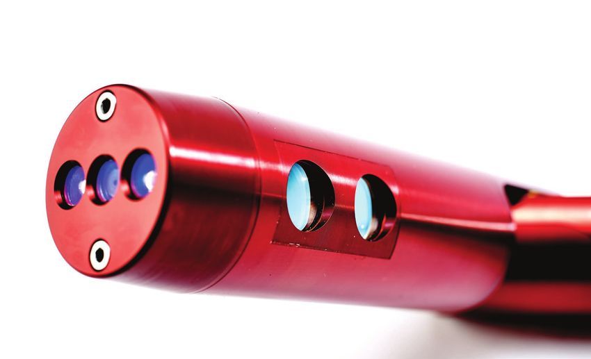
Key benefits of the C-ALS system

C-ALS supports successful projects                                The advantages of C-ALS laser scanning
C-ALS is a unique laser system that gives you new                 • The C-ALS system’s unique 50 mm diameter allows
underground mapping capabilities. You can safely, quickly and       deployment into cost-effective narrow boreholes
reliably scan inaccessible underground workings, and upload
                                                                  • Survey potentially dangerous underground voids safely
the scan data to your existing mapping software. This gives
you the information you need to:                                  • View results in minutes not days

• Protect worker safety                                           • Remotely controlled operation

• Report to project stakeholders in greater detail                • Flexible deployment methods

• Cost out planned works accurately                               • Easily transported

• Devise more efficient programmes of work                        • Precise and accurate cavity/void measurement

• Progress new projects                                           • Rugged design and construction ensures durability in
                                                                    extreme environments
• Design and engineer solutions based on accurate data
                                                                  • 360° spherical coverage gives you a full view from a single
• Minimise disruption, drilling and disturbance in
                                                                    scan, with no blind spots
  populated areas
                                                                  • The IP67 rating gives you the confidence that the Renishaw
Voids and abandoned mines can pose a serious potential
                                                                    C-ALS system can withstand submersion to a depth of
threat to worker and public safety due to the possibility
                                                                    1 m, reducing the risk of damage if accidentally deployed
of failure and collapse. Traditionally, investigations of
                                                                    into a flooded cavity. C-ALS can also withstand extremes of
inaccessible voids were impossible, or involved vast numbers
                                                                    temperature and high humidity
of exploratory boreholes. The Renishaw C-ALS system
enables laser scanning of air-filled voids in order to create
geo-referenced 3D models of subsurface conditions as a
cost-effective, comprehensive and accurate alternative to
systematic drilling.

In a wide range of applications – including underground and
open-cast mining, construction, subsidence investigations
and subterranean excavations – the C-ALS system ensures
that vital work is neither delayed nor prevented due to a lack
of data. It also avoids putting workers and the public at risk.
With low cost of ownership and minimal operator training
required (C-ALS does not need to be operated
by a surveyor), C-ALS opens up new
possibilities for safe, profitable
operations.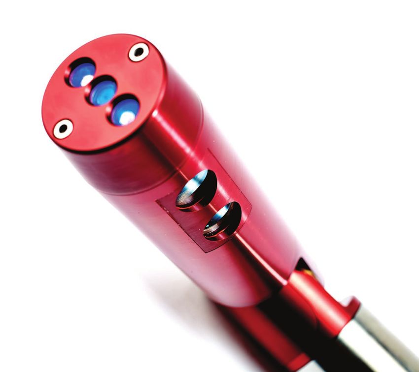
C-ALS applications

Unique ability to scan through even the                            Cavity surveys to support underground or
narrowest boreholes                                                surface mining projects
The Renishaw C-ALS system can be used in a huge range of           The existence of an underground void does not necessarily
applications where an inaccessible void exists and accurate        represent a significant subsidence hazard. However, by
data is required in order to monitor excavations, assess risk or   using C-ALS to determine the size and extent of openings,
design solutions, including:                                       spacing and size of pillars, mining customers have been able
                                                                   to evaluate and accurately assess risks. In many cases this
• Subsurface voids and cavities
                                                                   knowledge can be used to prepare for a range of ambitious
• Undercrofts                                                      new mining programmes.

• Underground chambers and tanks                                   Mine managers need a complete picture of the situation
                                                                   underground before committing to projects or deploying
• Duct surveys
                                                                   workers, and the C-ALS system supports them by providing
• Inaccessible roof spaces                                         data on the following:

• Subsidence investigations                                        • Excavation and infill of stopes

• Stope surveys                                                    • Accurate location of voids

• Ore passes                                                       • Geometry and condition of mine workings

• Collapsed mine workings                                          • Inaccessible historic workings

• Culverts                                                         • Collapsed areas

• Shafts and bunkers                                               • Erosion of ore-passes

• Underground caverns                                              • Volumes of voids

• Industrial production facilities with limited or unsafe access   • The position of cavities in relation to other underground
                                                                     workings and structures
Once deployed, C-ALS provides more detailed, accurate data
than alternative technologies, such as ground-penetrating          • Size of remaining pillars
radar, and is the only borehole-deployable laser-scanning
                                                                   • Failure mechanisms (sinkholes/troughing)
solution on the market.
                                                                   • Location of the workings relative to surface features
The C-ALS system can also be used to enhance safety
in areas where visibility is low or the entrance to a void is      C-ALS is ideal for providing 3D data on inaccessible
unstable. It can be deployed long distances into stopes on a       underground cavities. Mine managers can assess the stability
cable or rods, as well as on a boom and/or remote-controlled       of mine works and judge whether or not a cavity needs to
vehicle from a safe and secure area. Once C-ALS has entered        be filled, whether work can proceed, and what project plans
the unsafe void, data can be collected.                            should be put in place to maximise productivity and safety.

                                                                   Open-pit operations taking place over historic underground
                                                                   workings can pose serious threats to worker safety. The
                                                                   old mines will frequently be poorly mapped or will have
                                                                   shifted over the years due to collapse, void migration,
                                                                   flooding and seismic activity. A full understanding of the
                                                                   layout of underground workings and their relation to surface
                                                                   operations is essential to safe open-pit operations using
                                                                   heavy machinery, explosives and personnel. Traditionally, it
                                                                   has been very difficult or dangerous to collect this information.
                                                                   The Renishaw C-ALS system can be used from the surface
                                                                   to map out the network of old voids and to provide detailed
                                                                   visual record of the subsurface environment.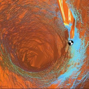
Void surveys in construction and geo-technical projects
Many different construction and geotechnical projects may need to identify, measure and map
voids below the project site. Where such voids cannot be easily or safely accessed, various
technologies, such as ground-penetrating radar may be used to detect the void, but results can
be limited by depth and geology, and can be difficult to interpret.
C-ALS is ideal for such applications. After locating the approximate position and extent of the
void/cavity from GPR or previously held data, a borehole is drilled into the void or cavity and
the C-ALS system is deployed via the borehole or other small access point. Once inside the
void, the laser head opens out to measure the 3D shape of the entire void. The scan data can The ruggedised PC enables you
then be analysed visually, measurements can be taken, and a volume calculated. to carry out operations on site in
extreme environments.
Pre- and post-construction subsidence surveys
The presence of old mine workings or voids underlying residential and commercial properties,
transportation and infrastructure facilities can cause differential settlement, sinkholes or even
catastrophic collapse.
While historic mine maps can help determine the geometry of voids, their depth, and the
nature of overlying strata, they do not help identify the results of retreat mining, pillar theft,
spontaneous collapse or other subterranean movements.
Engineering solutions can be put into place to counter problems caused by old underground
workings, but designing these solutions requires a complete picture of the situation
underground. By deploying the C-ALS system into these otherwise inaccessible areas, the C-ALS provides accurate point
required data can be collected and the area comprehensively mapped. cloud data in a matter of minutes
not days.
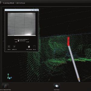
User-friendly software
Renishaw’s new software for C-ALS makes it easier and quicker for operators to use the
system, by guiding them through the process of deploying and scanning.
• Quicker navigation and intuitive design supports new operators
• Software, viewable on the connected PC, shows the scanner’s inclination and heading
at all times
• One-click surfacing and volume calculation from raw scan data enables you to obtain a
closed 3D model and volume within seconds of finishing a scan Laser cavity scans are easy
to export into a large range of
• Point cloud editing and visualisation can be conducted on site to support swift software packages.
operations
• Auto-connection to the C-ALS probe reduces setup time
• Live recording from the C-ALS camera into WMV makes it easy to save and share
video footage
• Live viewing of incoming point cloud data as a scan is in progress gives operators
peace of mind or allows for a new deployment
• Guided workflow reduces training needs and improves efficiency
• A 3D scanner icon models the heading and inclination of the C-ALS probe so that
operators can ‘see’ the probe, even when it is underground
• Export to a number of industry-standard formats, including LAS and DXF, allows easy
integration with third-party processing software packages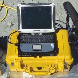
How it works
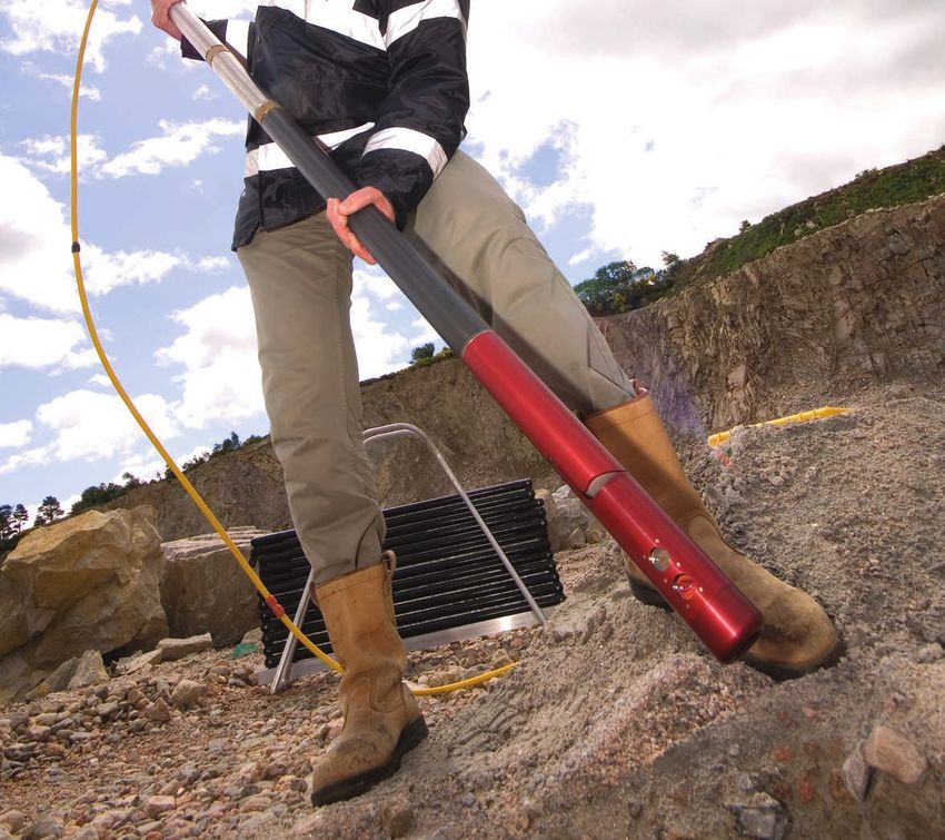
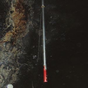
• With a diameter of just 50 mm, the Renishaw C-ALS system is easily deployed through
boreholes, downhole or uphole in order to survey inaccessible spaces.
• A system of hinged, lightweight, 1 m rods provide a fixed azimuth capability, as well as the
ability to deploy the C-ALS down boreholes as long as 200 m. C-ALS can also be deployed
by boom or by remote-controlled vehicle.
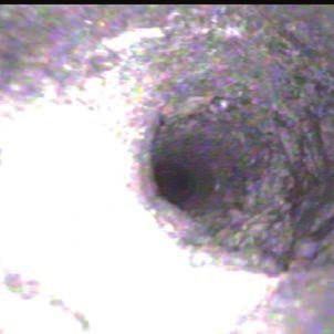
• A nosecone camera sits on the end of the C-ALS probe and provides an on-screen video
and a real-time view of the borehole as the probe is deployed, so operators can see any
obstructions, and judge the point at which C-ALS enters the void.
The C-ALS system deployed • The C-ALS probe incorporates pitch-and-roll sensors and has the option of an internal
downhole to survey an compass. The sensors ensure C-ALS can be tracked down the borehole and that the scan is
inaccessible underground void. automatically geo-referenced to fit into existing 3D mine data.
• Once in the void, a simple click from the operator tells the laser-scanning head to rotate on
two axes, measuring the three-dimensional shape of the void, with full 360-degree coverage
and no blind spots, and with a range up to 150 m.
• Operators control C-ALS from a distance, via the robust, rugged PC that is included in the
package. Built to work in tough conditions, this PC is linked to the C-ALS system by Ethernet
cable or a WiFi link. From a safe distance, they can view live data, analyse point clouds and
create models.
• The use of the remote PC keeps operators safe while offering broad visibility of the probe’s
location and what is happening underground.
C-ALS can be deployed by
methods including zipwire, booms
and remotely controlled vehicles.
The nosecone camera provides
a helpful view into the borehole
during deployment.
The probe rotates on two axes to
create full 360-degree scans of
voids and cavities.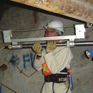
Renishaw plc                                     T +44 (0) 1904 736736
                                                 F +44 (0) 1904 736701
Redwood House, Northminster
                                                 E spatialmeasurement@renishaw.com
Business Park, York, North
Yorkshire, YO26 6QR, UK                          www.renishaw.com/mining

About Renishaw
Renishaw is an established world leader in engineering technologies, with a strong history of innovation in product development
and manufacturing. Since its formation in 1973, the company has supplied leading-edge products that increase process
productivity, improve product quality and deliver cost-effective automation solutions.

A worldwide network of subsidiary companies and distributors provides exceptional service and support for its customers.

Products include:
•   Additive manufacturing, vacuum casting, and injection moulding technologies for design, prototyping, and production applications
•   Advanced material technologies with a variety of applications in multiple fields
•   Dental CAD/CAM scanning and milling systems and supply of dental structures
•   Encoder systems for high accuracy linear, angle and rotary position feedback
•   Fixturing for CMMs (co-ordinate measuring machines) and gauging systems
•   Gauging systems for comparative measurement of machined parts
•   High speed laser measurement and surveying systems for use in extreme environments
•   Laser and ballbar systems for performance measurement and calibration of machines
•   Medical devices for neurosurgical applications
•   Probe systems and software for job set-up, tool setting and inspection on CNC machine tools
•   Raman spectroscopy systems for non-destructive material analysis
•   Sensor systems and software for measurement on CMMs
•   Styli for CMM and machine tool probe applications

For worldwide contact details, please visit our main website at www.renishaw.com/contact

RENISHAW HAS MADE CONSIDERABLE EFFORTS TO ENSURE THE CONTENT OF THIS DOCUMENT IS CORRECT AT THE DATE OF
PUBLICATION BUT MAKES NO WARRANTIES OR REPRESENTATIONS REGARDING THE CONTENT. RENISHAW EXCLUDES LIABILITY,

                                                                                                                                                   *L-5913-8001-01-A*
HOWSOEVER ARISING, FOR ANY INACCURACIES IN THIS DOCUMENT.

© 2014 Renishaw plc. All rights reserved.
Renishaw reserves the right to change specifications without notice
RENISHAW and the probe symbol used in the RENISHAW logo are registered trade marks of Renishaw plc in the United Kingdom and other countries.
apply innovation and names and designations of other Renishaw products and technologies are trade marks of Renishaw plc or its subsidiaries.       Issued: 0614 Part no. L-5913-8001-01-A
All other brand names and product names used in this document are trade names, trade marks or registered trade marks of their respective owners.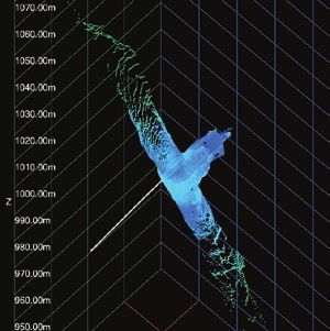
You can also read