CAMPUS AND THE CITY IN A SOUTH AFRICAN CONTEXT - Reflections on a UWC satellite campus in Mitchells Plain, Cape Town
←
→
Page content transcription
If your browser does not render page correctly, please read the page content below
CAMPUS AND THE CITY
IN A SOUTH AFRICAN CONTEXT
     Reflections on a UWC satellite campus
              in Mitchells Plain, Cape Town

                                   by Eva De Bruyn
Campus and the City in a South African Context.
Reflections on a UWC satellite campus in Mitchells Plain,
Cape Town.

Eva De Bruyn

Promotoren: prof. dr. ir.-arch. Johan Lagae, prof. dr. Pieter Uyttenhove
Begeleider: Bert Gellynck

Masterproef ingediend tot het behalen van de academische graad van
Master in de ingenieurswetenschappen: architectuur

Vakgroep Architectuur en Stedenbouw
Voorzitter: prof. dr. Pieter Uyttenhove
Faculteit Ingenieurswetenschappen en Architectuur
Academiejaar 2011-2012
CAMPUS AND THE CITY B. Mitchells Plain TOWN Centre spatial strategies 30
IN A SOUTH AFRICAN CONTEXT
0. Introduction 37
> Planning history
37
The ambition of a central business district
Reflections on a UWC satellite campus Free trade area
> Beautification 38
in Mitchells Plain, Cape Town > Demographic centre of gravity of Cape Town
> Spatial strategies for a UWC satellite campus in Mitchells Plain CBD
38
39
1. Mobility 41
PrefacE 4
> Mapping: mobility densities 41
> Mitchells Plain transport interchange 41
> Congestion on the train: the desire for new connections 41
Introduction > Satellite campuses in the search for an urban anchoring 6 > Integrated Rapid Transit and the need of the poor 43
> UWC Oral Health Centre in Mitchells Plain
Establishment of a satellite 7 Proposal 45
An island with a ferry Station Enclave
2. Public Space 51
Potential of the site > Mapping: blank walls
51
> A historical neglect of common space
51
> The dignified places programme
52
A. Mitchells Plain From garden city to high-density township 10 Freedom and diversity as basis for a public space initiative
The economic significance of public space
The notion of identity
> Security issues 54
0. Introduction 12
> Forced removals under Apartheid
> The Cape Flats as Apartheid’s dumping ground 57
3.Trade
> Mapping: trading patters 57
> Diversification of trading culture 57
> Formalization of informal trading 61
Proposal 63
1. Planning Ideology 15
> Creating a middle class New Town City Wall
15
The neighbourhood unit
The ownership society
> Apartheid social engineering 4. Catalytic Institutions 69
18
Township planning > Mapping: influences of formal actors 69
The modernist discourse as justification > Interplay of formal and informal systems 69
2. Implementation of the Ideal Plan 21
> A dormitory town 21
> Post-building investment 21 5. Vacant Land 73
Economic and spatial marginalization
> Mapping: vacant spaces 73
Administrative marginalization
> Typology of vacant spaces 73
Urban environmental quality
Public open space
> Moving up the ladder 22
Infrastructure leftovers
School sites
Wastelands Proposal 77
3. Informal Densification 25
> Informal provision of rental stock
Urban Web
25
> The preference of backyard dwellings over freestanding shacks 27
> A hidden housing crisis Bibliography 82
29
> The roots of backyard dwellings in formal urban policy
> Acknowledging the need for backyard dwelling 29 annex 1: cartography 86
88
annex 2: historical imagery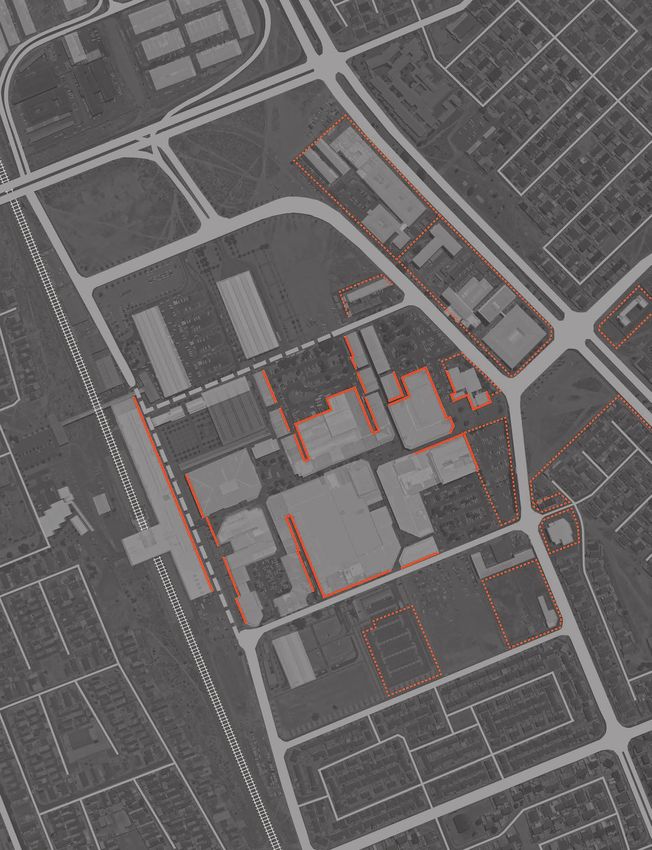
4   preface                                                                                                                                                                                                                                   preface    5

    Preface
    The initial intention of this thesis was to find out in what way the UWC faculty in Mitchells                                                             as to emphasize those elements that are structural for the current functioning of the
    Plain - a dense township in Cape Town - influences its surroundings, how it interacts with                                                                township.
    the local community and what lessons can be learned from this particular case to develop                                                                  This general structure of Mitchells Plain is then taken into account in part two, which
    a strategy for future satellite campuses. However, by conducting fieldwork in and around                                                                  focuses on Mitchells Plain’s town centre and the presence of UWC in it. By mapping the
    the Mitchells Plain campus, it became evident that there is surprisingly little interaction.                                                              town centre’s problems and potentials, three spatial strategies for the development of
    From the moment we arrived, we were advised not to leave the building or linger at the                                                                    the centre are discerned. In each of these, the possible role of UWC is explored and the
    entrance. Our questions on what is ‘outside’ were answered with a clear “we don’t go                                                                      implications of this model for the UWC campus are visualised by concrete projects.
    there” by both staff and students. Nevertheless, we perceived the town centre as one of                                                                   The designs are spread throughout part two, as they are not intended to offer a final
    the few lively places we found on the Cape Flats and although not always safe, it has an                                                                  solution but aim to feed the debate around the questions that should be on the agenda of
    urban feel and an active community. Therefore, my focus shifted: Mitchells Plain would not                                                                the university’s and city’s planning department.
    serve as case study to develop a scenario for other sites; it would become the site to
    work on.

    In conversations with the institutional planning department, it became apparent that
    developing ideas for an improved integration of the Mitchells Plain campus with its
    surroundings is not on the current agenda. There is an intention of buying more land
    adjacent to the existing building, but this is regarded as “a land bank” rather than an
    opportunity.1 Staff of the residing faculty nonetheless acknowledges the potential of the
    site, as it is located in the heart of a dense community, neighbouring one of the most
    important transport nodes of the Cape Town Metropolitan Area.2 This thesis therefore
    seeks to put the potentially interesting campus higher on the agenda of both the university
    and the City planning department. The objective of the work is twofold. On a more
    specific level, the aim is to start a polemic discussion on how the university campus in
    Mitchells Plain can be developed as a positive campus, as an investment of UWC that
    benefits both the university and the community. Three design scenarios intend to feed
    the discussion about the desirability and implications of a satellite campus in a deprived
    community. Secondly, the general undercurrent throughout the thesis is the search for
    an alternative to prevailing tendencies of urban design in the context of South African
    townships. The overall structure and issues of the studied township and the importance
    of local partnerships in urban design will feed the proposed scenarios.

    It is important to understand that my position as an outsider and a Belgian student
    coloured my view on the South African context. At the same time, I believe this allows to
    perceive things differently and to propose actions that are considered unrealistic by those
    that are confronted with the South African reality on a daily basis. I believe a certain form
    of naivety is crucial to shed new light on ongoing discussions. Reflecting on a two-month
    stay in Cape Town, our general impression can be summarized by a series of tensions,
    between visions and actions, the planned and the built, the public realm and the ‘gated’ city,
    tolerance and fear, international prestige and local engagement, etc.

    In what follows, I will specifically focus on the township of Mitchells Plain to explore
    these perceived tensions and their spatial implications. The introduction will delineate the
    spatial issues of UWC, both in general terms as specifically for the Faculty of Dentistry
    that resides in Mitchells Plain. The premise that forms the base of this thesis, namely the
    potential of a satellite development, will be outlined. The studied satellite campus will
    briefly be discussed as to sketch the current situation and intentions.

    The first part of this work studies the evolution of Mitchells Plain from the planned            1. Larry Pokpas, conversation held in Cape Town, 6
                                                                                                     September 2011.
    township over actual implementation to the current appropriation of space by residents.
                                                                                                     2. Neil Myburgh, conversation held in Mitchells Plain,
    Analysing the city structure in each of these phases allows redrawing the spatial structure      13 September 2011.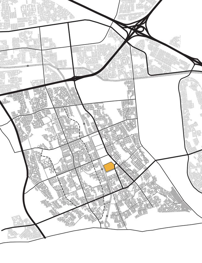
6 Introduction introduction 7
Introduction
Satellite campuses in the search for an urban anchoring the starting point for academic research on the Cape Flats in various research domains.
Outreach will thus become one of the research niches in which the university excels and
The University of the Western Cape (UWC) profiles itself as an institution on the edge
can form the identity with which UWC wishes to receive international recognition.
of “two worlds that define the South African context: a highly developed technologically advanced
world and an underdeveloped world”. “Many institutions are either located in the one or the other
world or have the choice - the luxury - to choose between the two worlds. (...)We operate deliberately UWC Oral Health Centre in Mitchells Plain
in the space which is the tension between those two worlds.”3 Because of its establishment In what follows, I focus on UWC’s satellite in the township of Mitchells Plain because of
in the 1960s as a university for the coloured community and its important role in the its exceptional location and unconventional functioning within the university’s network.
struggle for equality, UWC has always been committed to the disadvantaged population of Its outreach project is one of the few long-term community engagements UWC has
the Cape Flats. It intends to take on a role of urban actor and socially engaged university set up thus far. Nevertheless, it will be illustrated that the current situation offers little
by means of ‘outreach projects’ while simultaneously developing ‘a centre of excellence’. In interaction between the university and its surroundings. Located in the heart of the town
this search, the university is faced with its spatial context, surrounded by industrial areas centre of a coloured township, 20 kilometres from the main campus, this satellite raises
and undeveloped sites. In order to establish a more urban context and a community to questions about safety, autonomy, mobility and accessibility and could therefore shed a
engage with, UWC wishes to develop its immediate surroundings, specifically the Transnet different light on a development strategy for the University of the Western Cape.
site, into an environment that would be more conducive to the university’s aspirations.
In ‘UWC Off Campus Catalogue’, a scale comparison of the site with the centres of
Cape Town and Ghent illustrates the enormous scale of this development. It is therefore Establishment of a satellite
doubtful that a development of the complete site can be steered by UWC. It seems like an odd choice to locate part of a faculty 20 kilometres away from its other
campus. The history of the Faculty of Dentistry explains the move to Mitchells Plain as a
Instead of directing towards an urban development around its own campus, I want to desperate, yet strategic one. To complete the puzzle this history formed, we conducted a
argue that a model of satellite campuses could offer a more viable potential for the series of interviews, with the dean and former dean of the faculty, the responsible for the
embedding of the university in an urban environment. Furthermore, the seeds for this Mitchells Plain campus and former rector Jakes Gerwel, who each had a different story.
spatial strategy are already present today. Firstly, UWC’s student population is particularly Combining these stories with official documents and newspaper articles made it possible
characterized by its diverse origin. Because of the foundation of UWC as the sole to formulate a coherent chronology.
coloured university in the Western Cape, students are still drawn from various parts of When the faculty was founded in 1974, its facilities were located on the Tygerberg hospital
the peninsula. Recent data on students’ home addresses indicate that, except from those campus, a highly segregated site, where coloured UWC staff could not move freely, even
on campus, the majority does not reside near Bellville, but in the townships of Mitchells within the premises. In 1992, the faculty had to move out of the Tygerberg building. “UWC
Plain (1008 students), Athlone (928 students) and Lavenderhill (802 students), all situated faced an ultimatum to leave Tygerberg or close down. Instead, with profound material support
over 15 kilometres from the main campus.4 from the UWC Rectorate, Dentistry established itself in Mitchell’s Plain in the period 1992-
Secondly, UWC already holds some satellite campuses or buildings, as is mapped in the 2004”6 is the explanation given by Neil Myburgh, professor of Dentistry and responsible
first part of our research, ‘UWC off campus catalogue’. The origin of these satellites is for the Mitchells Plain site. The departure of UWC from Tygerberg is thus found as an
diverse and, most importantly, is not directed by a global and long-term vision. Students involuntary one, yet offered a solution to the difficult position on the Tygerberg site. Larry
generally appreciate these off campus sites, but explicitly state the lack of facilities that Pokpas states that “the situation [of racial segregation] was embarrassing, we had to move out”7
offer a valuable student life, such as spaces for social and extra-curricular activities. The 6. Premesh Lalu and Noëleen Murray, Becoming UWC:
and former rector Jakes Gerwel described Tygerberg as a condition in which “UWC was
current lack of an overall vision concerning the development of these satellites has resulted reflections, pathways and unmaking apartheid's legacy, almost what we call ‘bywoners’, squatters, on an Afrikaner site.”8 This resulted in an aspiration
in a rather ad-hoc planning that mainly responds to pressing needs, not opportunities. Cape Town: Centre for humanities research UWC, of the university to profile itself differently from the Stellenbosch dental faculty, by means
2012, p. 102. of a strong focus on community engagement.
Nevertheless, the mapped sites offer great potential in terms of community engagement,
7. Larry Pokpas, conversation held in Cape Town, 6 Consequently, the potential of buying part of a hospital in the heart of a deprived township
research potential and urban surroundings. September 2011.
Thirdly, over the past years the university has set up a large number of widely recognized was immediately recognized. “There’s about a million people in Mitchells Plain and a million
8. Jakes Gerwel, conversation held in Cape Town, 12
outreach projects. In my opinion, this is a true strength of UWC and should be reinforced. October 2011. more in Khayelitsha.That’s where the real needs are, not in Tygerberg.”9 This new location offered
With the exception of the dentistry faculty, the current outreach projects are of temporary 9. Larry Pokpas, conversation held in Cape Town, 6 UWC the possibility to provide dentistry services to patients as part of the students’
nature. They typically take place on weekends and count on voluntary participation of September 2011. practical training. Up to today, residents of Mitchells Plain can receive dental care at the
students and staff. The location and reached community varies for each project. A spatial 10. This decision was influenced by the post- ‘Mitchells Plain Oral Health Centre’ charged according to their income. Consequently, a
base could form the incentive for a more profound and long-term engagement with apartheid government that had always been supported large share of the faculty’s expenditure is subsidised by the government’s Department of
by UWC. The merger wasn't immediately accepted
specific communities. 3. Larry Pokpas, conversation held in Cape Town, 6 by the University of Stellenbosch, and led to a strong
Health, as it constitutes a form of community health service.
Moreover, by establishing satellite campuses in those areas that interest UWC in light of September 2011. polemic in the newspapers. Neil Myburgh writes on The Faculty of Dentistry was thus located solely in Mitchells Plain, until 2004, when a
community services, outreach becomes an integral part of the university’s programme. 4. Based on a database of student addresses in 2011 this matter that 'merger' is just a euphemism for what national merging of all dentistry faculties resulted in a single Faculty of Dentistry in the
provided by Vincent Morta at UWC. it actually was, a takeover. (Neil Myburgh in: Premesh Western Cape, assigned to UWC.10 Consequently, the current student population of
“Rather than isolate the service mission of the university through discrete activities and Lalu and Noëleen Murray, Becoming UWC: reflections,
5. David C. Perry and Wim Wiewel, The university as Dentistry partly consists of former Stellenbosch students, mostly coming from a white
programmes of ‘outreach’ and ‘extension’, it is becoming redefined as part of the core of activities urban developer : case studies and analysis, Cambridge, pathways and unmaking apartheid's legacy, p. 102.)
of an engaged university”5 A UWC satellite campus in a deprived community can form Mass.: Lincoln Institute of Land Policy, 2005. 11. University of the Western Cape, Annual Report upper class. This makes Dentistry a very unconventional faculty within the university, as
2010, Cape Town, 2010. the total white student population at UWC is only 600 on a total of 18.000 students.11
8 INTRODUCTION
The campus at Mitchells Plain represents a mix of higher-class students and students
originating from townships like Mitchells Plain but who, unlike most of their community,
have received the advantage of a good education. That this complex group of students is
trained in a place where the latter originate from and the former never come into contact
with, holds opportunities for creating a common ground, a middle group. It is this group of
students that forms an interesting ‘next generation’ and that represents the stated “tension
between two worlds”.
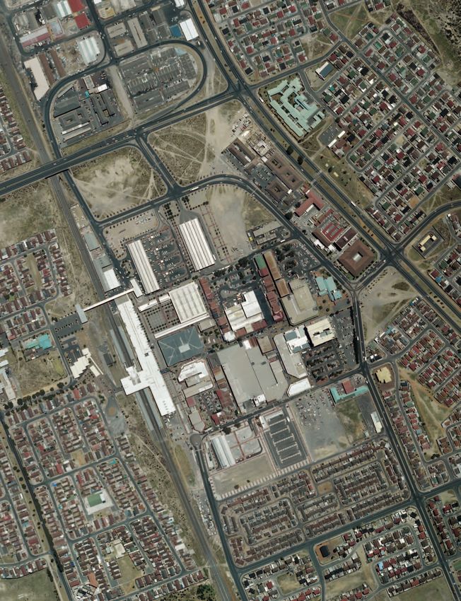
an island with a ferry
The Melomed hospital, where UWC owns two and a halve floors, is located on a
very prominent place in the town centre of Mitchells Plain. As the entire township is
Mitchells Plain hospital as viewed from train station
characterized by single-story standardised housing, Melomed stands out with its seven-
story building. Nonetheless, the presence of UWC does not reach further than the
‘UWC’-sign on this prominent building. The university only owns the fifth, sixth and part
of the first floor.The entrance is a small door in the central hall of Melomed Hospital, with
a security guard and two elevators that go straight to the UWC-owned floors. Thus, on a
spatial level there is no interaction between the faculty and it surroundings.
To bridge the distance between Mitchells Plain and the campuses at Bellville and Tygerberg,
a UWC transport system is put up.12 This shuttle is limited to one service in each direction
per day, leaving students little opportunity to linger longer or leave earlier. Students are
picked up at the residence in Tygerberg and transported to Mitchells Plain, where they
are dropped in front of the entrance. The situation is best characterized as “an island
with a ferry” as Gordon Pirie has put it.13 In its return to the campus, the bus is empty. As
discussed in ‘UWC Off Campus Catalogue’, the opportunity to deploy the empty ride
population density per km2, extracted from GIS data
back for transporting students residing in Mitchells Plain to the main campus should be per quantile (based on census 2001)
considered. inhabitants per km2:
0 - 356
356 - 1441
Potential of the site 1441 - 2321
Today, the University seems to struggle with defining the importance of the Mitchells 2321 - 3709
3709 - 7225
Plain site. It is financially interesting because of the government’s subsidies for providing 7255 - 46509
community services, it offers great potential for outreach activities, and students receive a
hands-on training. Nonetheless, the area has the reputation of being unsafe, which has led
up to the current isolated position of UWC in the Melomed ‘tower’.
Discussing the possibilities of this site is a very actual concern, as the University has
the opportunity to buy the adjacent parking lot to expand their facilities in the light 12. UWC's transport services are discussed in our
of a growing student population. As a meeting with the heads of the Faculty and the booklet 'UWC Off Campus Catalogue', p. 30-33.
institutional planning department14 revealed, the University is uncertain if they should 13. Gordon Pirie, conversation held in Cape Town, 12
leave Mitchells Plain or invest to make it a better functioning campus. October 2011.
14. Meeting concerning Tygerberg and Mitchells Plain
campus, Mitchells Plain, 12 September 2011. (Present:
Furthermore, the deprived township of Mitchells Plain is gradually being acknowledged by Larry Pokpas, Lois Dippenaar, Alex Robertson, Julian
city officials as an important region in the Cape Town Metropolitan Area (CTMA). A map elliot,yussuf Osman, Neil Meyburgh, eva De Bruyn, Ana
of population densities illustrates the relative size of Mitchells Plain’s population in relation Michelena)
to the entire CTMA.15 Investments in Mitchells Plain are on the rise16, thus the early 15. Mitchells Plain (outlined by a dotted line) is
presence of UWC in one of the most prominent spots can be considered an advantage. not the only dense area in the Cape Flats, but is
of significant size and is moreover planned and
The question then is: how can the university interfere in its surroundings and influence constructed as one coherent town.
city planning in a more pro-active way? Which spatial strategies can be conceived that will 16. Recent investments include upgrading
benefit both the university and the local community? programmes by the City of Cape Town and by the
National Government, a 86.000 m2 shopping mall, a
4-storey hospital and a privately funded mixed-use
housing project.
Mitchells Plain
From garden-city to high-density township
12 MITCHELLS PLAIN MITCHELLS PLAIN 13
> INTRODUCTION > INTRODUCTION
INTRODUCTION
The township of Mitchells Plain was built in the 1970s as a dormitory town for the the cape flats, apartheid’s dumping ground
coloured community. Following the rules of apartheid planning, it was to ensure a strict
In Cape Town, the relocations and subsequent urban segregation roughly meant that the
separation of the coloured population from other racial groups in Cape Town.
central and western part of the city became a whites only area, while all other racial
Being the fourth largest township of South-Africa17, the amount of research done on
groups were transferred to the Cape Flats, an uninhabited and climatically hostile plain
Mitchells Plain is surprisingly low. Most works deal with socio-economic issues and often
approximately 30 kilometres east of the city centre. Before 1960, this area was practically
look at Mitchells Plain solely in the context of gangsterism and drug abuse. This chapter
deserted except from the few farms in between the barren dunes.
aims to discuss the development of this township in spatial and ideological terms and
From the 1960s on, the Flats became known as apartheid’s dumping ground. Large-
is based on the analysis of planning documents, existing research and own fieldwork
scale building operations established several new towns, destined to house the biggest
observations.
number possible at the smallest expense. These government-built townships were merely
dormitory towns, entirely dependent on Cape Town for jobs and services. In the 1970s, the
After a brief introduction on the context in which Mitchells Plain originated, its
majority of the Flats’ inhabitants were coloureds, as the Western Cape was designated as
development will be studied by marking three phases: the original intentions with
a Coloured Labour Preference Area since 1955. The intention was to remove all Africans
the underlying ideology, the actual implementation of the plan and the current rapid
from this region and relocate them in the destined rural ‘homelands’. This only changed in
densification. Studying the evolution will make it possible to redraw the plan of Mitchells
1985 when the black settlement Khayelitsha was built and many Africans were relocated
Plain as to mark those spatial elements that are crucial and that can inform the ensuing
to the new township in an attempt to control illegal settlements.23
design proposals. The cartography for each section thus serves as a tool for analysis,
The term ‘coloured people’ eventually encompassed not only Cape Malay24 and all people
parallel to the study of literature.
of mixed race, but also Indians and other Asians. Because of this broad definition of the
coloured group, the newly established ‘communities’ were artificial constructions of
forced removals under apartheid apartheid’s social engineering. They did not share a common past, which made it difficult
Racial inequality and the development of apartheid in South Africa are firmly rooted in to establish a distinct identity and sense of community in the townships. In many cases, this
the colonial area.18 Already under the British rule, laws were constituted that regulated led to disrespect and low association with the living environment, resulting in high crime
black native movement and residence in the country. The Natives Land Act (1913) was rates and violence.25
the first law that regulated segregated living areas for the indigenous population. It defined
specific ‘native reserves’ for Black communities and is thus considered as the first stage
in drawing a permanent line between Africans and non-Africans. Later, similar regulations > Town planning scheme for the Cape Flats
for urban areas were laid down in the Natives Urban Areas Act (1923) that required local indicating land considered for coloured group areas.
governments to establish separate locations for black communities. This was realised and The darkest areas (west) are districts containing
justified by means of large-scale state housing schemes, funded by the central government white and coloured group areas.
under the Housing Act (1920). Although the Act contained no racial connotations, “it was Mitchells Plain (‘L’) is described as ‘private land
expected that local authorities ‘will do their duty and provide for the coloured and native people possible coloured urban settlement’.
within their areas’”.19 The complex judicial system of pre-apartheid segregation acclaimed
to be based on administrative motives, without official racial connotation. It tried to
“impose racial segregation in a non-racial manner”.20 17. Information and Knowledge Management
Department City of Cape Town, A Review of Literature
Emanating from and Related to the City Of Cape Town’s
It was only after the election of the Afrikaner National Party in 1948 that segregation Urban Renewal Programme, Cape Town, 2006.
on explicit racial base was formalized, resulting in isolated spatial structures and inbuilt 18. A. J. Christopher, The atlas of changing South Africa,
inequalities in all facets of urban life.The Population Registration Act that was implemented 2nd ed., London ; New york: Routledge, 2001, p. 10-17.
from 1950 on divided the population in four racial groups: white, African (black), coloured
19. Minister of Public Health Sir Thomas Watt, as
and Asian. Consequently, this provided the authorities with the opportunity to determine quoted in: A.J. Christopher, The atlas of changing South
strict living areas for each racial group within the city as was implemented by the Group Africa, p. 36.
Areas Act (1950). Achieving this racial segregation led to enormous forced removals for 20. A. J. Christopher, The atlas of changing South Africa, 23. A. J. Christopher, The atlas of changing South Africa,
those residing in the ‘wrong’ racial zone. 21 p. 30-36. p. 121-122.
One of the most well known evictions took place in District Six, at that time a lively and 21. errol Haarhoff, "Appropriating modernism: 24. The Cape Malays are descendants of the slaves
racially mixed area near the Cape Town CBD.22 In 1966, this district was declared as a Apartheid and the South African township," ITU Journal imported into the Cape Colony by the Dutch in the
whites only area because of its proximity to the city centre and the port. Sixty thousand of the Faculty of Architecture, Istanbul,Turkey, vol. 8, no. 1, seventeenth and eighteenth century. They adopted the
2011, p. 188. Afrikaans language, but are mostly Islamic. (ibid., p. 21)
people were forcibly removed and their houses bulldozed. Up to today, the site largely
remains a void in the urban landscape. Many of the former residents later arrived in 22. Originally established as a mixed community 25. Charlotte Lemanski, "Houses without community:
Mitchells Plain. of freed slaves, merchants, artisans, labourers and problems of community (in)capacity in Cape Town,
immigrants (http://www.districtsix.co.za/) South Africa," Environment and Urbanization, vol. 20,
2008.
mitchells plain 15
> planning ideology
1. Planning Ideology
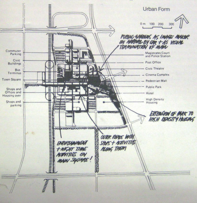
< re-drawing of the original New Town plan of Little is written on the underlying planning ideals that have inspired the design of Mitchells
Mitchells Plain. Based on historical maps, planning Plain. In the following section, I want to develop the argument that Mitchells Plain is based
schemes and descriptions. on two motives: firstly the influence of British new towns and the neighbourhood unit
grid roads
concept, and secondly, the social engineering of apartheid-based city planning. We will see
loop
local neighbourhood roads
how Mitchells Plain perfectly answers the statement that “the modern movement provided a
pedestrian green connections rationale for advancing the programme of spatial segregation as a largely technical exercise that
suburban centre enabled the social and political contradictions involved to be sidestepped.”26 The reconciliation
density of 80 inhabitants/ha of racial segregation with imported town planning principles that originally advocated
positive social outcomes is a contradiction that characterizes the plan for Mitchells Plain.
This argument is based on an analysis of the original planning documents27, combined
with newspaper articles from the 1970s and work by scholars, notably Noëleen Murray
26. Errol Haarhoff, "Appropriating modernism:
who conducted research on townships in the northern Cape Flats, Errol Haaarhoff who
Apartheid and the South African township.", p. 184. studied the appropriation of the modernist discourse in South Africa, Charlotte Lemanski
who did extensive study on housing in townships and A.J. Christopher’s book ‘The Atlas of
27. Documents containing original maps, interviews
with involved planners or text by planners were Changing South Africa’.
found in the archive of the Mitchells Plain library - a
modest yet interesting loose collection of reports and
newspaper articles on the construction of Mitchells Creating a middle class New Town
Plain - and the Built Environment library of the
University of Cape Town, where we found several Mitchells Plain was designed in 1971 within the City of Cape Town’s engineering
folders containing pamphlets, reports and historical department, with a significant influence of private consultants, architects and planners.28
maps on urban developments in the Cape Flats. Several of the involved planners later became important figures within the Cape Town
28. Engineering department City of Cape Town, Planning department, such as J.G. Brand and David Jack who were responsible for the
Motivation to receive the award of 'most outstanding civil
engineering achievement', Cape Town, 1980. (archives of
planning and construction of Mitchells Plain. The latter was to become the first City
Mitchells Plain library) Planner at the formation of the city’s planning department in 1986.29
A number of architects were invited to design sections of the plan, such as Roelof
29. Ibid.
Uytenbogaardt, who later became head of UCT’s architecture and planning department
30. Noëleen Murray, Designing the common:The
Chamber of Commerce Group Housing Project at Belhar
and played a key role in South African planning by developing “an alternative urban vision and
(unpublished paper), Cape Town: University of the approach to planning, which proved to be highly influential in the post apartheid era”.30
Western Cape, 2011.
31. David Dewar et al., The structure and form of At that time it was estimated that the backlog of housing for the coloureds in Cape Town
Metropolitan Cape Town: its origins, influences and
was about 30.000 dwellings, including some 7.700 for squatter families. On top of that, the
performance (working paper), Cape Town: The Urban
Foundation, 1990, p. 63. City took into account the high growth rate of the coloured community and decided the
establishment of housing for 250.000 people was needed. To get an idea of the scale of
32. Denis Mabin, Mitchells Plain (paper presented
at the conference of the Institute of Housing
this development it can be compared with populations of long established South-African
Management, Durban September 1977). (UCT Built cities in the 1970s. Bloemfontein, the capital of the Free State and judicial capital of South
Environment library) Africa counted approximately 184.000 inhabitants; Cape Town then counted 740.000
33. J.G. Brand, Building a new town: City of Cape Town's inhabitants.31 The brief for Mitchells Plain was thus formulated as a housing project aiming
Mitchells Plain of Work (report), Cape Town, 1979. (UCT to house 250.000 people on a 3100 hectares land by the end of 1984.32
Built Environment library)
34. The neighbourhood unit concept initially emerged The neighbourhood unit
in the USA as an anti-urban philosophy that sought to
promote an alternative urban living encapsulating the Prior to the development of Mitchells Plain, the emphasis for non-white settlements in the
qualities of the village, which was thought to be more Western Cape had been on providing housing at the lowest cost possible, neglecting the
conducive to a stable family life. The inwardly oriented
provision of an interesting urban environment. The aspiration of Mitchells Plain however
residential areas that would remind of small towns and
villages was one of the main concepts that influenced was to offer a counterpart to this tendency by creating a middle class township that would
the plan for Mitchells Plain. kickstart a cycle of upward mobility and would “temper rebellion amongst the urban poor”.33
David Dewar et al., The structure and form of Metropoli- It was conceived as a ‘model township’ based on an interpretation of the ‘neighbourhood
tan Cape Town: its origins, influences and performance
(working paper), p. 33-35. unit’34 and British New Towns of the 20th century. Especially the influence of Milton
Keynes is evident from the plan and is literally referred to by consulting architect Revel
35. "Special Report Mitchells Plain," Financial Mail 5
May 1978, p. 7. (archives of Mitchells Plain library) Fox as “the only other New Town of similar size, and planned and designed to similar standards
as Mitchells Plain”.35
1 km
16 MITCHELLS PLAIN MITCHELLS PLAIN 17
> PLANNING IDeOLOGy > PLANNING IDeOLOGy
< Interpretation of the diagram for a typical The city of Milton Keynes, designed in 1967, forms part of a third generation of British New
neighbourhood (Westridge) Towns. It combined the coherent town planning of the first generation, such as Harlow,
and the more urban aspirations of the second generation, which criticized the earlier New
Towns for being anti-urban. Milton Keynes thus represents a strong reaction to a number
of the earliest New Town principles such as the concentration of all services in the heart
of the unit and the consequent centralized road system, which leads to congestion in the
centre. The Milton Keynes road system is a hierarchically organized grid that avoids any
specific centre. Wide arterial roads demarcate the separate neighbourhood units, which
are inwardly focused and only have local traffic. The overall grid is slightly curvilinear as
it follows the topography of the site. Non-motorised traffic is separated from the grid
roads, allowing pedestrians to circulate safely without using any of the high-order arterials.
Local facilities such as primary schools are situated at the centre of a neighbourhood
cell, whereas shopping areas and other traffic-generating functions are located at the
perimeter of the unit, for example on the crossing of two arterials.36
The initial plan for Mitchells Plain is clearly based on the same principles. Public facilities
are grouped at major arterials. Neighbourhood units can be crossed by pedestrians using
a secondary network of open spaces that cut through the residential areas. Each unit is
Strategic plan for Milton Keynes, 1969: developed differently, providing various forms of housing, including freestanding, semi-
residential area detached and duplex housing. Five suburban centres, one for each pair of suburbs, were
employment area
centre planned, completed with one overall town centre in the heart of the township.37 These
civic centre secondary schools suburban centres were to include shopping facilities and community facilities such as a
grid roads + 2nd order roads + pedestrian web open space library, a multipurpose hall and a clinic. A distinction was made between functions that
might generate inter-suburban traffic and more local facilities such as a school and sport
facilities, that had to be provided in every single suburb and were therefore located along
the pedestrian green connections.
In order to define the relationship between different elements of the plan and the logics
that structured it, I will briefly focus on the first built suburb of Mitchells Plain, called
Westridge, because it followed the plan meticulously. As the analysis of its structure
shows, a difference is made between functions that would draw traffic from outside the
neighbourhood - civic centres and high schools -, those that generate some traffic, but
mainly within the unit - churches - and functions that should be safely accessible by foot -
primary schools. Every ‘area’ delineated by roads had its own primary school accessible by
green spaces that formed an internal pedestrian network. Placing primary schools in each
local area was seen as a tool to create a local community. Secondary schools were placed
at the crossing of the pedestrian network with the road, as they tend to draw students
from distant neighbourhoods. An elongated suburban centre along a major arterial road
contained a community centre, an all-purpose civic hall, a family health care clinic, a library,
a visitor centre, supermarkets, shops and offices.
The example of Westridge formulated directives to which all suburbs in Mitchells Plain
were to be designed. Ideas that were generated in the plan for Mitchells Plain were used
36. Steen eiler Rasmussen, "Reflections on Milton
Keynes," Architectural Design, vol. 64, no. 10, 1994.
in several later townships, as it was generally accepted to “represent a most significant shift
37. "Special Report Mitchells Plain."
in [urban design] thinking”.38 The collective places that were envisaged at Mitchells Plain in
38. Nuttall, Jean, 1993, ‘Roelof Uytenbogaardt’,
the form of linear spaces gathering community functions around them were to become an
Transvaal Institute of Architects (TIA) Journal, Architectural important aspect of the approach to urban design set out by Roelof Uytenbogaardt and
press, Cape Town, November 1993, as quoted in: the City’s planning department from that time on.39 Nevertheless, in Mitchells Plain as well
Noëleen Murray, Designing the common:The Chamber of as in the successive new towns, Uytenbogaardt’s idealised public spaces and playgrounds
Commerce Group Housing Project at Belhar (unpublished
paper). have given way to dangerous and alienating open spaces. “It is as if the modernist spaces
high schools primary schools churches 100 m of the South African new towns conceived under apartheid are not liveable”, Noëleen Murray
grid roads + local roads + pedestrian web local roads + pedestrian web 2nd order roads 39. Ibid.
40. Ibid. concludes.40.18 MITCHELLS PLAIN MITCHELLS PLAIN 19
> PLANNING IDeOLOGy > PLANNING IDeOLOGy
the ownership society group area, while the other group areas were restricted to peripheral locations with little
“Mitchells Plain is an instrument for social transformation, cultural upliftment, educational expansion possibilities. These guidelines reflect the model apartheid city as was applied in
advancement and hence human development. (...) It will provide the goals and incentives for the whole country.46
the less privileged of the community to better themselves and pull themselves up ‘by their own Extensive new residential areas such as Mitchells Plain illustrate the far-reaching extent
bootstraps’.”41 This statement by J.G. Brand, city engineer during the years Mitchells Plain of governmental control over the detailed planning of the city. As the ideal plan proposes,
was planned, illustrates a shift that took place in township planning in the seventies. Mitchells Plain was located on a peripheral location, with no expansion options. Up until
‘The Cape Flats as dumping ground’ was showing its side effects; ghettos of the urban today, the township is bounded by the Philippi agricultural area in the west, the coastline
poor were being formed along the edges of Cape Town, surrounding the city with an in the south, a buffer of protected dunes in the east and the R300 highway in the north.
uncontrollable mass of people. It was acknowledged that something needed to be done
to alleviate the poor’s living conditions. Moreover, most new townships consisted of The modernist discourse as justification
households that were forcefully relocated from every corner of Cape Town, thus lacking The rationale of the modernist movement seemed to provide the ideal justification
any shared background. To “promote a community spirit of belonging”, Brand insisted on newspaper advertisement Financial Mail, 5 May 1978
for spatial segregation. By pointing to modernist planning and its positive outcome
stepping away from the governmental subsidized rental housing and move towards more proclaimed by the New Town movement, apartheid constructions such as Mitchells Plain
homeownership. Households were assigned a house on a repayment period of 30 years. were justified by stressing the “unique opportunities” that would arise in these newly built
“prestigious surroundings”.47 The first completed neighbourhood, Westridge, was used by
The emphasis on policies providing property titles to low-income households as a means the South African state as a showcase to illustrate the national township housing policy
of social upliftment has become a strategy common to governments throughout the to international guests.48
global South, though not without critics. The integration of poor households into the
capitalist economy by using state-subsidized homeownership is intended to provide poor In ‘Appropriating modernism: Apartheid and the South African township’, Errol Haarhoff
people with an asset that can be used in a productive manner. “The basic premise is that traces the early impact of the modern movement in South Africa and the emergence of
poverty-alleviation at an individual or household level is intrinsically linked to homeownership. In close relationships between local and European protagonists. The spread of the modern
other words, government provides beneficiaries with their first step on the property ladder and movement towards South Africa appeared as early as 1928, when an architectural study
then hands them over to the existing capitalist housing market in which they now have a stake, trip by the University of Cape Town included a visit to the just completed Bauhaus in
with the implicit assumption of market integration, upward mobility and collateral security.”42 Dessau. Students from several other universities followed and soon became leading
characters of the modern movement in South Africa. In 1938, a conference was organised
In contrast to other relocation township schemes, the marketing of Mitchells Plain did not by students at the University of the Witwatersrand, including presentations on Le
focus on its high number of cheap dwellings for the thousands of homeless families; it was Corbusier’s work, modernist town planning and, most remarkably, hypothetical projects
advocated as a modern and prestigious living environment, “providing homes, not houses”.43 for a ‘model native township ‘.This model was produced as a student thesis “to demonstrate
The general idea was to establish a middle-class coloured community, entirely in line with the application of rational, modern planning and design approaches” on the prevailing practice
the imported modernist models. of racial segregation.49 It combined the overall structure of the neighbourhood unit ideal
with concepts of Le Corbusier’s Radiant City: the building units were conceived as large
apartheid social engineering tower blocks, each with a primary school and a cultural centre, surrounded by green open
space.50
township planning In the 1950s, the formal appropriation of modern principles appears as a base to justify the
In 1955, specific guidelines for demarcating the boundaries of group areas within cities were 46. A. J. Christopher, The atlas of changing South Africa,
state’s mass housing programs. Under the commission of the National Building Research
drawn up by the Land Tenure Advisory Board. These guidelines for the ‘ideal’ segregated p. 103-104. Institute, national standards for state funded housing were drawn up, with a specific focus
town plan propose a sectoral pattern - created by dividing the land radially starting from on minimizing costs.The Garden City model was adopted to justify the peripheral location
47. Newspaper advertisement in: "Special Report
the CBD - with blocks for each group that allowed for further extension outwards. The Mitchells Plain", p. 10. of townships and their separation from the city by ‘green’ buffer zones.51
sectors were to be separated by 30 metres wide buffers of open land, complemented with 41. J.G. Brand, Building a new town: City of Cape
48. engineering department City of Cape Town,
rivers, ridges, industrial areas, railways, etc.The plan aimed to limit links between the racial Town's Mitchells Plain of Work (report), p. 2.
Motivation to receive the award of 'most outstanding
The planning of neighbourhoods equally received a lot of attention in the housing
groups, preferably with no direct roads between the different group areas.44 42. Charlotte Lemanski, "Moving up the Ladder civil engineering achievement', Cape Town, 1980, p. 15. standards, although it was stressed that “in Native housing schemes, the first object is to simply
The guidelines were formulated in very practical terms, allowing for a meticulous or Stuck on the Bottom Rung? Homeownership supply shelter at minimum cost, and the second to create an environment conducive to living a
as a Solution to Poverty in Urban South Africa," 49. errol Haarhoff, "Appropriating modernism:
implementation and a re-organization of South African cities over a short time span. They International Journal of Urban and Regional Research, vol. Apartheid and the South African township", p. 186-190
full and happy life”52. The remark that “if such pedestrian access [to schools and playing fields]
were incorporated in manuals for town planning, such as the guidebook for township 35, no. 1, 2011, p. 58. could be entirely free of any roads used by vehicles, then planning would be ideal,” suggests the
planning by Floyd: “Railway lines, main roads, rivers, streams and ridges all form separation 50. See image in annex same influence of the neighbourhood unit as later applied in the plan for Mitchells Plain.
43. "Special Report Mitchells Plain." David Dewar et al., The structure and form of
media and these should be used as far as possible. Where no suitable feature of this sort exists, Metropolitan Cape Town: its origins, influences and
44. A. J. Christopher, The atlas of changing South Africa,
the Group Area Board may insist on a buffer strip. In the case of native locations buffer strips can p. 103-104. performance (working paper), p. 50-53. Although the plan for Mitchells Plain did comply to the national standards concerning
vary from 200 to 500 yards.”45 dwelling units, it forms a special case in township planning because of its strong and
51. errol Haarhoff, "Appropriating modernism:
In practical terms, given the white dominance in the Advisory Board, some alterations 45. T.B. Floyd, Township Layout, Pietermaritzburg: Apartheid and the South African township", p. 190. primary focus on neighbourhood qualities. Adopting the model of New Towns such as
were added to the plan: in virtually every city, the central zone was planned as white Shuter and Shooter, 1951, p. 204. Milton Keynes allowed for major investments in infrastructure that could not have been
52. Calderwood, D.M., Native Housing in South Africa
(1953), as quoted in ibid. justified in the preceding native township planning schemes.mitchells plain 21
> implementation of the ideal plan
2. Implementation of the ideal plan
< plan of Mitchells Plain after implementation. This chapter will discuss how the stated ‘ideal township plan’ was implemented. It will
The open spaces are coloured white, as they are reveal which crucial parts are left out and how the local context plays an important role
not implemented and maintained as planned. Of in the success of its intentions, creating a tension between the ideal (imported) plan and
the five planned suburban centres, only two were
the reality of the township.
constructed.The loop was not completed.
grid roads
loop A dormitory town
local neighbourhood roads
suburban centre Although J.G. Brand portrayed Mitchells Plain as a “self-contained viable addition to the
density of 80 inhabitants/ha Metropolitan area of Cape Town”, it remained a dormitory town lacking job opportunities,
sufficient recreational facilities and social services. The origin of this deficiency can be
traced back to the decision to establish another coloured township,Atlantis, 45 kilometres
north of Cape Town. Both Mitchells Plain and Atlantis were initially conceived as self-
contained new towns on the periphery, yet a significant difference existed between both
townships as Mitchells Plain was the responsibility of the Cape Town City Council, while
Atlantis was a national government initiative. Consequently, both areas were developed in
competition with each other.The intent of Atlantis was to move heavy industry out of the
centre of Cape Town while simultaneously ensuring that the factories had a ready supply
of cheap manual labour, by relocating part of the coloured community there. By means of
new legislations constraining the development of industry in metropolitan areas, industrial
development in Mitchells Plain was disallowed by the government in order to promote
Atlantis as a coloured ‘decentralisation’ point.53 The success of Atlantis in relocating the
coloured working class thus depended somehow on the ‘failure’ of Mitchells Plain in
providing employment sites.
Despite the lack of job opportunities, Mitchell Plain was still intended to provide a “full
range of community facilities”54 As stated before, a suburban centre was planned for each
pair of suburbs and on top of that, one main town centre.55 Most of these have never
been realised or remained the mere collection of a few supermarkets. Although the first
completed neighbourhood Westridge followed the plan meticulously and thus included a
53. The idea of 'decentralisation points' was put into
practice since the 1940s. The main intention was to town centre, it has devaluated and lost its importance as a centre on a higher scale than
create industrial nodes in the homeland areas as to the local unit.
discourage African migration towards the city centres. The failure of the suburban centres rendered Mitchells Plain far more monofunctional than
Further legislation in the 1970s imposed constraints
on the industrial expansion in metropolitan areas
originally intended. This placed large pressure on the main town centre, that would not
and also aimed to control the coloured population in only serve the whole area of Mitchells Plain, but also the even less serviced neighbouring
urban areas. township Khayelitsha.
David Dewar et al., The structure and form of Metro-
politan Cape Town: its origins, influences and performance
(working paper), p. 68-69 and 79. Post-building investment
54. J.G. Brand, Building a new town: City of Cape
Town's Mitchells Plain of Work (report). Economic and spatial marginalization
55. "Special Report Mitchells Plain." Several of the current issues in Mitchells Plain illustrate a gap between the initial intentions
56. "Census 2001‐ Mitchells Plain," 2001, http://www. and the reality in which they were implemented, particularly in relation to the actual socio-
capetown.gov.za/en/stats/2001census/Documents/ economic context. The acute poverty in the area is one of those factors that were not
MitchellsPlain.htm.
Planning department, Spatial Development Framework;
taken into consideration in the idealistic New Town plan. According to the 2001 census,
Khayelitsha and Mitchells Plain district plan, Cape Town, half of the population of Mitchells Plain is unemployed, with one third of households living
2011. below the poverty line.56 As stated, job opportunities in the surroundings of Mitchells Plain
57. Cecil Madell, "Guidelines for the development of have always been limited. Even in the few retail centres, shops were predominantly owned
central business districts in townships in South Africa," by national retailers who did not rely on local labour. The fierce competition with white-
in Proceedings of the Planning Africa 2006 Conference, ed. owned chain stores led up to the establishment of only a few locally owned businesses
M.; Madell Cullinan, C.; Watson,V., Cape Town: South
African Planning Institute, 2006, p. 15. in the area.57 Furthermore, because of a shift from a traditional manufacturing economy
to a service sector economy with a focus on tourism, financial services and computer
1 km22 mitchells plain mitchells plain 23
> implementation of the ideal plan > implementation of the ideal plan
technology, the formal economy of Cape Town is increasingly unable to provide a significant account the lacking structural base of social and economic opportunities.
number of jobs to the poorly educated and unskilled residents of the townships.58 Whilst Secondly, occupants seemed unable to maintain their homes and pay for necessary
recent investments in Mitchells Plain reflect the changing perception of the area and a costs. After receiving a standard house, they had to invest in plastering, floorboards,
growing recognition of the business opportunities, these have mostly been in the form ceiling, bathroom appliances, etc.65 This contradicted strongly with the requirement that
of shopping mall development rather than a mix of economic activity with greater job households had to provide evidence of a low income to be eligible for state-funded
potential. Consequently, the only opportunity for employment lies either in the informal housing. Furthermore, Lemanski’s research in a Cape Town low-income settlement
sector or in industrial sites as Bellville and Epping, at significant transportation costs.59 indicates that homeownership brings pressure to exhibit ‘proper living’ by purchasing
furniture, electrical appliances and decorations that are not deemed essential in informal
Administrative marginalization settlements, thus further increasing the financial burden of homeownership. “Ironically,
the inadequate income that provided qualification for a housing subsidy, constrains them from
Besides the economic and spatial marginalization of the Cape Flats townships, their
enjoying the financial and social benefits of homeownership.”66
administration was also kept apart from ‘white’ Cape Town. Together with the spatial
segregation, each racial group was afforded its own type of local government, albeit
Thirdly, township housing does not seem to function as an asset for upward social
with very different capacities and powers. Cape Town was divided in 69 racially based
mobility. The economic and spatial marginalization of Mitchells Plain undermined the
municipalities. Thus tax revenues were also collected locally. This formed a major problem
ideal of homeownership as a means of cultural (and financial) upliftment. The intention
for local authorities in areas such as Mitchells Plain, since the low income of its population
that households could use their property as assets on the housing market did not
and the small amount of formal businesses provided the municipality with little revenue.
coincide with the reality. Up to today, Cape Town’s property market shows an extreme
In 1996, governmental bodies in Cape Town Metropolitan Area were reformed. Six
gap between subsidised housing and the next rung of private dwellings.67 Although state-
municipalities were formed, in such a way that every township was linked to a more
subsidized houses are considered a financially tradable asset, the small dwelling sizes and
affluent area in order to collect sufficient tax revenue to help redistribute resources.
typically peripheral location have resulted in transaction values that are too low for low-
Nevertheless, this system cannot count for general support from the more affluent
income owners to secure upward movement to the next rung on the property ladder.68
population who believe their money is spent in areas where each investment means an
The majority of subsidy-beneficiaries are thus locked into a self-contained market. As a
outflow of cash without any return.60
result, the social and racial polarisation resulting from apartheid policies has not been
amended.The patterns of land economy confirm and contribute to the racial homogeneity
Urban environmental quality of certain township areas. This persistent spatial divide is further intensified by current
As a consequence to the low tax revenues pre-1996 and the little support on township building operations. Despite the recommendations in the Spatial Development Framework
65. "Special Report Mitchells Plain."
development post-1996, investments by authorities have been consistently low after the to work towards a more evenly spread provision of low-cost housing, this document has
66. Charlotte Lemanski, "Moving up the Ladder or
establishment of Mitchells Plain. This resulted in a general neglect of public amenities and no binding powers.69 The high land and housing prices in all areas except the southern
Stuck on the Bottom Rung? Homeownership as a
of urban environmental quality. The intended common space and pedestrian web is not Solution to Poverty in Urban South Africa", p. 71. Cape Flats force low-cost housing developments to the same region that already consists
maintained and in many cases even never laid out as a valuable public open space, resulting of disproportionate poor communities.70 The land economy thus confirms the historic
in “the exceptional blandness of the township landscape”.61 67. Catherine Lowe Besteman, Transforming Cape segregated spatial patterns in Cape Town.
Town, Berkeley: University of California Press, 2008, p.
50.
One of the results of the high-standard plan for Mitchells Plain is that certain amenities
have been provided in abundance. It seems as if schools are overprovided in the original 58. Steven Robins, "Planning fictions," in Desire lines: 68. In Charlotte Lemanski, "Moving up the Ladder
space, memory and identity in the post-apartheid city,
areas of Mitchells Plain and are provided with immense open spaces that were never fully ed. Noëleen Murray, Nick Shepherd, and Martin Hall,
or Stuck on the Bottom Rung? Homeownership as a
Solution to Poverty in Urban South Africa.", Charlotte
laid-out. Certain centrally located areas in the town centre and around stations have been London ; New York: Routledge, 2007. Lemanski assessed the South African ‘housing subsidy
reserved for higher order development and are still vacant. Many of these underutilised 59. Planning department, Spatial Development system’ using extensive data on property prices in a
properties still belong to the City, which presents both a challenge as well as an interesting Framework; Khayelitsha and Mitchells Plain district state-subsidized housing settlement in Cape Town.
opportunity for further development and densification.62 plan, Cape Town, 2011.
69. The Cape Town Structural Development
60. Ivan Turok, "Persistent Polarisation Post-
Framework (SDF) is a long-term planning document
Apartheid? Progress towards Urban Integration in
for the entire Metropolitan Area, further divided in
Moving up the ladder Cape Town," Urban Studies, vol. 38, no. 13, 2001, p.
eight medium-term (10 years) District SDF's. The
2368.
process includes several rounds of public consultations.
In ‘Planning Fictions’, Steven Robins wonders how “city planners and officials came to believe The process towards a draft plan started in 2001
61. Iain Low, Space and Transformation, in: Edgar (ed.)
that individual home ownership could dramatically transform the social fabric of a working-class Pieterse, Counter-currents : experiments in sustainability in and was completed and approved in May 2012. It is
neighbourhood characterised by exceptionally high levels of unemployment, crime, gangsterism the Cape Town region, Auckland Park: Jacana Media, 2010, the first large-scale planning documents after the
and violence?”63 The ‘ownership society’ that formed the ideological base of Mitchells Plain p. 211. apartheid era 'Guide Plans', but has little legal power.
The documents are accessible via: www.capetown.gov.
did not have the intended effect on several levels. 62. The last proposal in part 2 of this work will start za/en/sdf.
from the potential of the vast open spaces to propose
an integrated urban network. 70. Ivan Turok, "Persistent Polarisation Post-
First of all, the intention of Mitchells Plain to create “good governance and virtuous consumer- Apartheid? Progress towards Urban Integration in
63. Steven Robins, "Planning fictions," p. 21.
citizens out of the raw material of bricks, mortar and ‘the unruly masses’”64 did not take into Cape Town", p. 2368.
64. Ibid., p. 23.You can also read