Can coastal cities turn the tide on rising flood risk? - Climate risk and response: Physical hazards and socioeconomic impacts Case study April ...
←
→
Page content transcription
If your browser does not render page correctly, please read the page content below
Climate risk and response: Physical hazards and socioeconomic impacts

Can coastal cities
turn the tide on
rising flood risk?
Case study
April 2020

McKinsey Global Institute

Since its founding in 1990, the McKinsey     innovation, and urbanization. Recent        partners and industry and management
Global Institute (MGI) has sought to         reports have assessed the digital           experts. The MGI Council is made
develop a deeper understanding of the        economy, the impact of AI and automation    up of leaders from McKinsey offices
evolving global economy. As the business     on employment, income inequality,           around the world and the firm’s sector
and economics research arm of McKinsey       the productivity puzzle, the economic       practices and includes Michael Birshan,
& Company, MGI aims to provide leaders       benefits of tackling gender inequality,     Andrés Cadena, Sandrine Devillard,
in the commercial, public, and social        a new era of global competition,            André Dua, Kweilin Ellingrud,
sectors with the facts and insights          Chinese innovation, and digital and         Tarek Elmasry, Katy George, Rajat Gupta,
on which to base management and              financial globalization.                    Eric Hazan, Acha Leke, Gary Pinkus,
policy decisions.                                                                        Oliver Tonby, and Eckart Windhagen.
                                             MGI is led by three McKinsey & Company      The Council members help shape the
MGI research combines the disciplines of     senior partners: James Manyika,             research agenda, lead high-impact
economics and management, employing          Sven Smit, and Jonathan Woetzel.            research and share the findings with
the analytical tools of economics with       James and Sven also serve as co-chairs      decision makers around the world. In
the insights of business leaders. Our        of MGI. Michael Chui, Susan Lund,           addition, leading economists, including
“micro-to-macro” methodology examines        Anu Madgavkar, Jan Mischke,                 Nobel laureates, advise MGI research.
microeconomic industry trends to better      Sree Ramaswamy, Jaana Remes,
understand the broad macroeconomic           Jeongmin Seong, and Tilman Tacke are        The partners of McKinsey fund MGI’s
forces affecting business strategy and       MGI partners, and Mekala Krishnan is an     research; it is not commissioned by
public policy. MGI’s in-depth reports have   MGI senior fellow.                          any business, government, or other
covered more than 20 countries and                                                       institution. For further information about
30 industries. Current research focuses      Project teams are led by the MGI            MGI and to download reports for free,
on six themes: productivity and growth,      partners and a group of senior fellows      please visit
natural resources, labor markets, the        and include consultants from McKinsey       www.mckinsey.com/mgi.
evolution of global financial markets,       offices around the world. These teams
the economic impact of technology and        draw on McKinsey’s global network of

In collaboration with McKinsey & Company's Sustainability and Global Risk practicies
McKinsey & Company’s Sustainability          advances and enable lasting performance     landscape accelerated and amplified by
Practice helps businesses and                improvements for new players and            social media. We apply deep technical
governments reduce risk, manage              incumbents alike.                           expertise, extensive industry insights,
disruption, and capture opportunities        www.mckinsey.com/sustainability             and innovative analytical approaches to
in the transition to a low-carbon,                                                       help organizations build risk capabilities
sustainable-growth economy. Clients          McKinsey & Company’s Global Risk            and assets across a full range of risk
benefit from our integrated, system-         Practice partners with clients to go        areas. These include financial risk,
level perspective across industries from     beyond managing risk to enhancing           capital and balance sheet–related risk,
energy and transport to agriculture and      resilience and creating value.              nonfinancial risks (including cyber, data
consumer goods and across business           Organizations today face unprecedented      privacy, conduct risk, and financial crime),
functions from strategy and risk to          levels and types of risk produced by        compliance and controls, enterprise risk
operations and digital technology. Our       a diversity of new sources. These           management and risk culture, model risk
proprietary research and tech-enabled        include technological advances              management, and crisis response and
tools provide the rigorous fact base         bringing cybersecurity threats and          resiliency—with a center of excellence for
that business leaders and government         rapidly evolving model and data risk;       transforming risk management through
policy makers need to act boldly with        external shifts such as unpredictable       the use of advanced analytics.
confidence. The result: cutting-edge         geopolitical environments and climate       www.mckinsey.com/
solutions that drive business-model          change; and an evolving reputational risk   business-functions/risk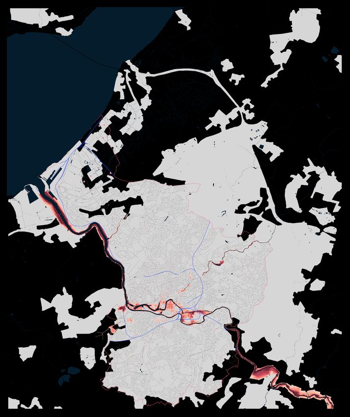
Can coastal cities
                                turn the tide on
                                rising flood risk?
                                Case study
                                April 2020

Authors
Jonathan Woetzel, Shanghai

Dickon Pinner, San Francisco

Hamid Samandari, New York

Hauke Engel, Frankfurt

Mekala Krishnan, Boston

Brodie Boland, Washington, DC

Peter Cooper, London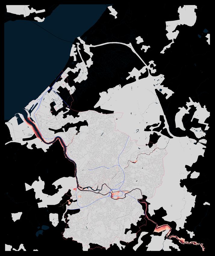
4
Introduction to case studies

In January 2020, the McKinsey Global Institute published Climate risk and response:
Physical hazards and socioeconomic impacts. In that report, we measured the impact of
climate change by the extent to which it could affect human beings, human-made physical
assets, and the natural world. In order to link physical climate risk to socioeconomic impact,
we investigated nine specific cases that illustrated exposure to climate change extremes
and proximity to physical thresholds. We explored risks today and over the next three
decades and examined specific cases to understand the mechanisms through which climate
change leads to increased socioeconomic risk. This is one of our case studies, focused on
city inundation.
We investigated cases that cover a range of sectors and geographies and provide the basis
of a “micro-to-macro” approach that is a characteristic of McKinsey Global Institute research.
To inform our selection of cases, we considered over 30 potential combinations of climate
hazards, sectors, and geographies based on a review of the literature and expert interviews
on the potential direct impacts of physical climate hazards. We found these hazards affect five
different key socioeconomic systems: livability and workability, food systems, physical assets,
infrastructure services, and natural capital.
We ultimately chose nine cases to reflect these systems and based on their exposure to the
extremes of climate change and their proximity today to key physiological, human-made, and
ecological thresholds (Exhibit 1). As such, these cases represent leading-edge examples of
climate change risk. Each case is specific to a geography and an exposed system, and thus
is not representative of an “average” environment or level of risk across the world. Our cases
show that the direct risk from climate hazards is determined by the severity of the hazard and
its likelihood, the exposure of various “stocks” of capital (people, physical capital, and natural
capital) to these hazards, and the resilience of these stocks to the hazards (for example, the
ability of physical assets to withstand flooding). We typically define the climate state today as
the average conditions between 1998 and 2017, in 2030 as the average between 2021 and
2040, and in 2050 between 2041 and 2060. Through our case studies, we also assess the
knock-on effects that could occur, for example to downstream sectors or consumers. We
primarily rely on past examples and empirical estimates for this assessment of knock-on
effects, which is likely not exhaustive given the complexities associated with socioeconomic
systems. Through this “micro” approach, we offer decision makers a methodology by which to
assess direct physical climate risk, its characteristics, and its potential knock-on impacts.
Climate science makes extensive use of scenarios ranging from lower (Representative
Concentration Pathway 2.6) to higher (RCP 8.5) CO2 concentrations. We have chosen to
focus on RCP 8.5, because the higher-emission scenario it portrays enables us to assess
physical risk in the absence of further decarbonization. Such an “inherent risk” assessment
allows us to understand the magnitude of the challenge and highlight the case for action.
(We also choose a sea level rise scenario for one of our cases that is consistent with the RCP
8.5 trajectory). Our case studies cover each of the five systems we assess to be directly
affected by physical climate risk, across geographies and sectors. While climate change
will have an economic impact across many sectors, our cases highlight the impact on
construction, agriculture, finance, fishing, tourism, manufacturing, real estate, and a range of
infrastructure-based sectors. The cases include the following:
— For livability and workability, we look at the risk of exposure to extreme heat and humidity
  in India and what that could mean for that country’s urban population and outdoor-based
  sectors, as well as at the changing Mediterranean climate and how that could affect
  sectors such as wine and tourism.

Climate risk and response: City inundation                                                         5
— For food systems, we focus on the likelihood of a multiple-breadbasket failure affecting
      wheat, corn, rice, and soy, as well as, specifically in Africa, the impact on wheat and coffee
      production in Ethiopia and cotton and corn production in Mozambique.

    — For physical assets, we look at the potential impact of storm surge and tidal flooding
      on Florida real estate and the extent to which global supply chains, including for
      semiconductors and rare earths, could be vulnerable to the changing climate.

    — For infrastructure services, we examine 17 types of infrastructure assets, including
      the potential impact on coastal cities such as Bristol in England and Ho Chi Minh City
      in Vietnam.

    — Finally, for natural capital, we examine the potential impacts of glacial melt and runoff
      in the Hindu Kush region of the Himalayas; what ocean warming and acidification could
      mean for global fishing and the people whose livelihoods depend on it; as well as potential
      disturbance to forests, which cover nearly one-third of the world’s land and are key to the
      way of life for 2.4 billion people.

6   McKinsey Global Institute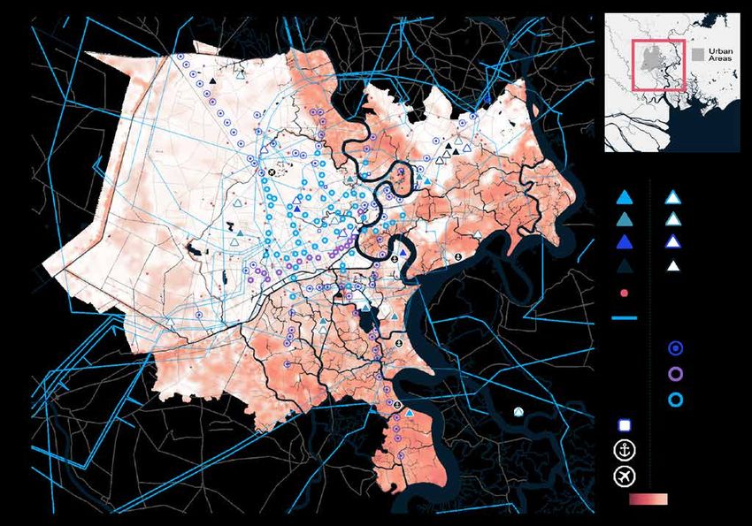
Ex
Exhhib
    ibit
       it 1
We have selected nine case studies of leading-edge climate change impacts across all
major geographies, sectors, and affected systems.

                                                                    7

                                                                                   2
                               5
                                                                                                           1          6
                                                                           4                                      7

                                                   Global case studies         3        8      9

Heat stress1 Low                       High           Highest drought risk in 20502                   Increase in hurricane/cyclone severity

                                               1       Will India get too hot to work?
      Livability and workability
                                               2       A Mediterranean basin without a Mediterranean climate?

                                               3       Will the world’s breadbaskets become less reliable?
      Food systems
                                               4       How will African farmers adjust to changing patterns of precipitation?

                                               5       Will mortgages and markets stay afloat in Florida?
      Physical assets
                                               6       Could climate become the weak link in your supply chain?

                                               7       Can coastal cities turn the tide on rising flood risk?
      Infrastructure services
                                               8       Will infrastructure bend or break under climate stress?

      Natural capital                          9       Reduced dividends on natural capital?

1. Heat stress measured in wet-bulb temperatures.
2. Drought risk defined based on time in drought according to Palmer Drought Severity index (PDSI).
Source: Woods Hole Research Center; McKinsey Global Institute analysis

                                     Climate risk and response | Case study: City inundation                                               7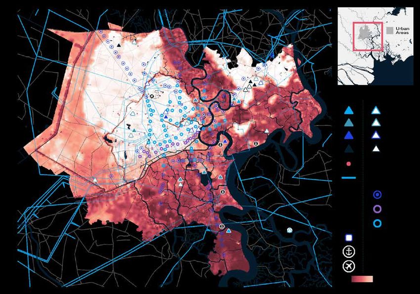
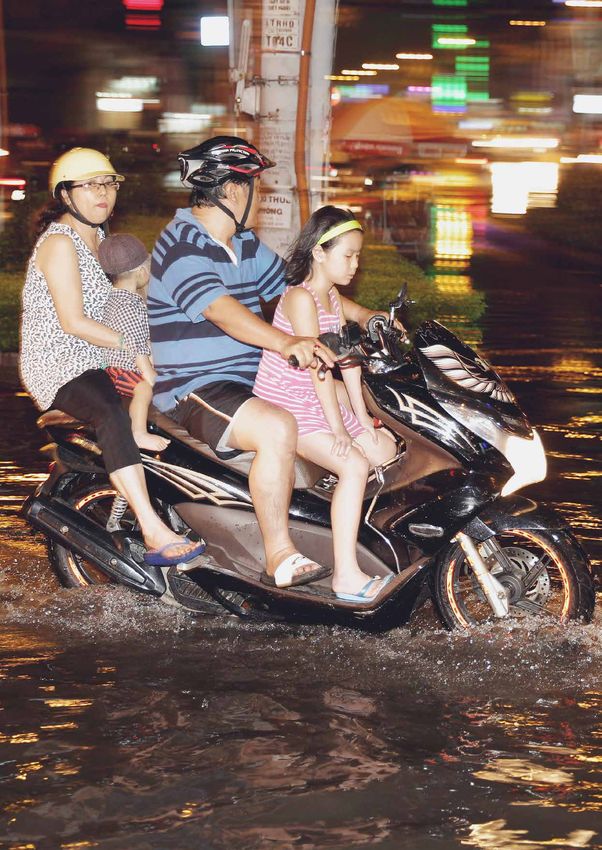
A family rides a motorbike through flooded streets after a rainstorm in Ho Chi Minh City.
© Sean Gallagher/Getty Images
City inundation
Can coastal cities turn the tide on rising flood risk?
Climate change is increasing the destructive power of flooding from extreme rain and from
rising seas and rivers. Many cities around the world are exposed. Strong winds during storms
and hurricanes can drive coastal flooding through storm surge. As hurricanes and storms
become more severe, surge height increases. Changing hurricane paths may shift risk to
new areas. Sea-level rise amplifies storm surge and brings in additional chronic threats of
tidal flooding. Pluvial and riverine flooding becomes more severe with increases in heavy
precipitation. Floods of different types can combine to create more severe events known as
compound flooding. With warming of 1.5 degrees Celsius, 11 percent of the global land area
is projected to experience a significant increase in flooding, while warming of 2.0 degrees
almost doubles the area at risk.1

Urban areas in coastal and riverine environments are on the front line of flooding, and
development in these areas is increasing the world’s exposure to the risk. These locations
have favorable characteristics for urbanization: adjacency to seas and rivers facilitate
transportation, and flood plains offer sources of fresh water and flat land for rapid
development, among other benefits. At the same time, their urban development has been
destroying natural surfaces and increasing nonpermeable surfaces like concrete that limit
drainage. The ever-increasing demand for land in urban areas encourages development in
higher flood risk areas. To make space for this growth, levees are increasingly narrowing
rivers, reducing their flow capacity.

The combination of increased hazard and increased exposure will compound physical climate
risk. Coastal cities that have historically faced major flood risks, such as Dhaka, Guangzhou,
Miami, Mumbai, New Orleans, and New York, will find that more of their population and assets
are at risk. Other cities will face a substantial threat of flooding for the first time. In the United
States, 90 coastal communities currently battle chronic flooding, and this number is expected
to double in 20 years.2 Qingdao, China, is projected to experience a 2,000 percent increase in
exposure by 2070. 3 Many major African cities, including Lagos, Luanda, and Mogadishu, will
also experience a step change in risk.

When cities flood, in addition to often devastating human costs, real estate is destroyed,
infrastructure systems fail, and entire populations can be left without critical services
such as power, transportation, and communications. For example, during Hurricane
Sandy in 2012, up to eight million homes lost electricity. 4 During Hurricane Harvey in 2017,
$10 billion of infrastructure was damaged, and most casualties were people attempting to
use transportation systems. 5 During Hurricane Irma in 2017, up to 95 percent of cell phone
towers were destroyed on some Caribbean islands.6 Infrastructure systems often serve a
population larger than that of the corresponding city. The increasing severity of extreme
floods can complicate recovery and repair, affecting populations reliant on these services for
longer durations.

1
    Petra Döll et al., “Risks for the global freshwater system at 1.5°C and 2°C global warming,” Environmental Research
    Letters, April 2018, Volume 13, Number 4.
2
    Laura Parker, “Sea level rise will flood hundreds of cities in the near future,” National Geographic, July 12, 2017.
3
    Susan Hanson et al., “A global ranking of port cities with high exposure to climate extremes,” Climatic Change, January
    2011, Volume 104, Number 1.
4
    David Sheppard and Scott DiSavino, “Superstorm Sandy cuts power to 8.1 million homes,” Reuters, October 30, 2012.
5
    “Hurricane Harvey: Most fatalities occurred outside flood zones, Dutch-Texan research shows,” European Geosciences
    Union, April 2018; Collin Eaton, “Hurricane Harvey’s damage to Texas infrastructure estimated at $10 billion,” Houston
    Chronicle, September 1, 2017.
6
    GSMA, The 2017 Atlantic hurricane season: Mobile industry impact and response in the Caribbean, March 2018.

Climate risk and response | Case study: City inundation                                                                       9
Whether cities are disrupted or devastated comes down to small differences in their location,
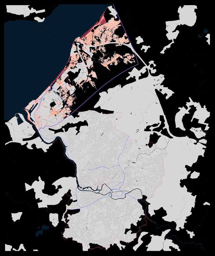
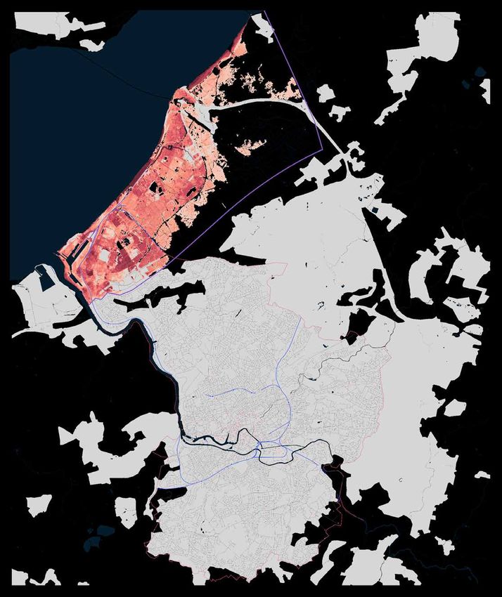
layout, and adaptation. In our case study, we simulate floods at the most granular level (up
to two-by-two-meter resolution) and explore how flood risk may evolve for Ho Chi Minh
City in Vietnam and Bristol in the United Kingdom (see Box, “Our methodology”). Our aim
is to illustrate the changing extent of flooding, the landscape of human exposure, and the
magnitude of societal and economic impacts.
We chose these cities for the contrasting perspectives they offer: Ho Chi Minh City in an
emerging economy, Bristol in a mature economy; Ho Chi Minh City in a historic flood area,
Bristol in an area developing a significant flood risk for the first time. Each city suffers in
different ways, but both may experience a step change in threat over the next 30 to 40 years
and need to take adaptive action.
The metropolis of Ho Chi Minh City can survive its flood risk today, but its plans for rapid
infrastructure expansion and continued economic growth could, if not managed carefully,
lead to an increase in risk. The city has a wide range of adaptation options at its disposal but
no silver bullet.
In the much smaller city of Bristol, we see a risk of flood damages growing from millions to
billions of dollars, driven by high levels of exposure. The city has fewer adaptation options
at its disposal, and its biggest challenge may be building political and financial support
for change.
Ho Chi Minh City will need to boost adaptation spending to cope with
nonlinear flood risk
Ho Chi Minh City is a defining feature of the Vietnamese growth story, contributing
approximately a quarter of the country’s total GDP. The metropolis is home to eight to
nine million people, plus an estimated two million migrant workers.7 The World Economic
Forum describes the country’s economy as a “miracle of growth”; it has expanded 6 to
7 percent a year over the past decade. 8 By several estimates, Vietnam could average
5 percent growth a year over the next 30 years.9 By 2050, this would make Vietnam the
20th-largest economy in the world, ahead of Canada, Italy, and Spain.
To fuel this growth, Ho Chi Minh City is expected to dramatically expand infrastructure
systems. Electricity use is expected to nearly triple from 2015 to 2030.10 On average, at least
~100,000 more people may require housing each year between now and 2050, and access
to running water and electricity will be necessary.11 About 200 infrastructure point assets are
currently being planned for construction by 2050.12 These projects span a diverse range of
services needed to meet the needs of a growing and prospering population, including a new
metro system, four power plants, nine wastewater processing plants, three water processing
plants, four port developments, five data centers, and a new airport. Further expansion is
likely planned in roads, electrical transmission infrastructure, and other “continuous” assets
for which spatial data are not readily available. Vietnam has already undergone a major
infrastructure revolution. In 2016, 99 percent of the Vietnamese population used electricity
as its main source of lighting, up from 14 percent in 1993 while rural access to clean water
improved over the same period from 17 percent to 70 percent.13
7
Ho Chi Minh City Adaptation to Climate Change Volume 2: Main Study Report
8
Peter Vanham, “The story of Viet Nam’s economic miracle,” World Economic Forum, 2018.
9
John Hawksworth, Hannah Audino, and Rob Clarry, The world in 2050: The long view: How will the global economic order
change by 2050?, PwC, February 2017.
10
Khanh Vu, “Vietnam will face severe power shortages from 2021: ministry,” Reuters, July 31, 2019.
11
UN Development Programme, Migration, resettlement and climate change in Viet Nam, April 14, 2014.;City population
2050, Ontario Tech University
12
We define point assets as individual infrastructure items such as power stations, train stations, and water treatment
plants, distinct from continuous infrastructure assets such as roads, transmission lines, and railroad tracks.
13
“The World Bank in Vietnam,” World Bank.
10 McKinsey Global InstituteBox
Our methodology
In our analysis, we use hydrological 1. We first define a flood of a given considered perspectives on the value at
simulations, land use maps of real recurrence interval (for example, a stake or the inherent risk from inaction
estate, infrastructure databases, “100-year” flood, with the equivalent rather than predictions of the future.
and damage curves to examine the of 1 percent annual probability).
expected impact of flooding on Ho Chi Additionally, significant uncertainty
Minh City and Bristol.1 We particularly 2. We then explore what that flood surrounds flood simulations,
focus on infrastructure due to the might look like in different years particularly in the degree of redundancy
knock-on effects associated with its based on forecasts of the evolution in systems, variations in asset-specific
outage. Our analysis selects flood of flood risk in each city. We discuss flood tolerance, and unpredictability in
events appropriate to a city’s risk (for this from three perspectives: visually, recovery timelines. Knock-on effects
example, extreme “acute” floods or in a high-resolution flood map, at are particularly unclear because
regular “chronic” floods) and time least ten-meter-by-ten-meter; they rely on the duration of impact,
periods appropriate to each city’s financially, from direct damage to which shows significant historic
development trajectory. In each case infrastructure and real estate; and variation, and the GDP production
study, we follow the same process: economically, from the associated associated with very specific areas,
knock-on effects.2 which is rarely recorded. However,
we find stark difference in impacts
3. For Ho Chi Minh City, we add a step between the same severity of flood in
and review the impacts of regular different time periods (for example, a
flooding at a city-wide level. 0.5 percent probability flood in Bristol
in 2065 would have 17 times greater
4. We then discuss different adaptation damage and 22 times greater knock-on
options that cities may consider. effects than a 0.5 percent probability
flood today). We believe this provides
These simulations reflect flood insight into the magnitude of flood risk
defenses as they stand today and do increase for each city.
not model future adaptation measures.
Furthermore, infrastructure standards We are grateful for the collaborators
and real estate development plans who have provided data and detailed
are considered only in relation to best review of our flood simulation, including
predictions up to about five years Bristol City Council, Asian Development
in the future. Even if adaptation Bank, Viet Nam National University of
measures are being planned today, Ho Chi Minh, and the Vrije Universiteit
when and how they will manifest is Amsterdam. Our Ho Chi Minh City case
uncertain. In addition, flood simulations analysis had significant input from the
considering these measures are not research team involved in Scussolini et
readily available. It is likely that both al. (2017). 3 In addition, we would like to
cities will take some form of adaptation thank Arup for providing a detailed peer
investments over the next 30 years. review of the methodological approach.
Therefore, these simulations should be
1
Our simulation methodology was peer reviewed by engineering consultancy Arup.
2
If not indicated differently, we follow standard practice and define current and future (2030, 2050) states as average climatic behavior over multidecade periods.
Climate state today is defined as average conditions between 1998 and 2017, in 2030 as average between 2021 and 2040, and in 2050 as average between 2041 and
2060. 2065 is taken as an instantaneous point in time. Also, if not indicated differently, the climatological analyses in this case use RCP 8.5 to represent the changes in
atmospheric greenhouse gas concentrations that could occur under absent a mitigation response. Please see technical appendix of the full report for details.
3
Paolo Scussolini et al., “Adaptation to sea level rise: A multidisciplinary analysis for Ho Chi Minh City, Vietnam.” Water Resources Research, 2017, Volume 53,
Number 12, pp. 10841–57.
Climate risk and response | Case study: City inundation 11Flooding is a common part of life in Ho Chi Minh City. This includes flooding from monsoonal
rains, which account for about 90 percent of annual rainfall, tidal floods and storm surge
from typhoons and other weather events.14 Different sources can combine to create more
powerful floods.15 Forty to 45 percent of land in the city is less than one meter above sea level,
which, combined with concentrated annual rainfall, results in extensive and frequent flooding.
Of the city’s 322 communes and wards, 154 have a history of regular flooding.16 However,
while flooding has historically caused property damage, threatened safety, and disrupted
transportation, it has not been severe enough to prevent the city from achieving high rates of
economic growth.
Rapid urbanization is raising the risk and intensity of floods. The city is already showing
evidence of a heat island effect, which may influence precipitation.17 Between the decade
from 1997 and 2006, Ho Chi Minh City’s average temperature increased 0.34 degree,
compared with an increase of 0.16 degree in the wider Mekong Delta region; this difference
is expected to widen as urbanization continues.18 Urbanization further brings a reduction in
permeable surfaces and increases the risk of land subsidence due to building, which has
already been observed in the Mekong Delta region and could be as much as three times as
significant in terms of flood risk increase as sea-level rise.19 A major driver of increased flood
severity of a given return period is sea-level rise, which contributes to exacerbated storm
surges. Precipitation increases could further worsen pluvial and riverine flooding, but there is
no clear consensus on where in Vietnam precipitation will change or by how much. Extremes
of either supply or shortage are, however, expected to become more common.
Economic growth is also causing land use changes that increase exposure to flooding. The
central parts of the city, typically safer due to natural elevation, are “hollowing out” as the
growth of commercial and high-end residential real estate pushes people toward more
affordable regions on lower ground. Migrants and poorer populations, with the least economic
power, are increasingly finding housing in higher flood risk areas. Ho Chi Minh City is already a
destination for climate change migrants, particularly rural agricultural victims of flood fleeing
to start a new life in the metropolis.20 As the effects of climate change continue to lead to
flooding on Vietnam’s coast over the next several decades, migrant populations are likely to
increase. These migrants may in fact be re-exposing themselves to risk.
In our analysis, we quantify the possible impact on the city as floods hit real estate and
infrastructure assets.21 Infrastructure assets covered include both those currently available
and those under construction, planned, or speculated. Knock-on effects are adjusted for
estimates of economic and population growth.22 We simulate 1 percent probability flooding
scenarios for the city for three periods: today, 2050, and a longer-term worst-case scenario
of 180 centimeters of sea-level rise. While the third scenario is not predicted in the next
14
Tran, Thong Nhat. “Improvement of flood risk assessment under climate change in Ho Chi Minh City with GIS
applications,” 2014.
15
Nguyen Ba Thuy et al “Monsoon-induced surge during high tides at the southeast coast of Vietnam: A numerical
modelling study,” Geosciences, 2019, Volume 9, Number 2.
16
HCMC Adaptation to Climate Change Study Report –Volume 2: Main Report -Final Report, Asian Development
Bank in collaboration with the HCMC Peoples Committee and DONRE Prepared by ICEM –International Centre for
Environmental Management, 31 July 2009.
17
Asian Development Bank, “Ho Chi Minh City adaptation to climate change,” 2009.
18
HCMC Adaptation to Climate Change Study Report, Asian Development Bank in collaboration with the HCMC Peoples
Committee and DONRE, Prepared by ICEM –International Centre for Environmental Management, 31 July 2009.
19
Hiroshi Takagi, Nguyen Danh Thao, and Le Tuan Anh, “Sea-level rise and land subsidence: Impacts on flood projections
for the Mekong Delta’s largest city,” Sustainability, September 2016, Volume 8, Number 9; and Dinh Ho Tong Minh
et al, “Mapping ground subsidence phenomena in Ho Chi Minh City through the radar interferometry technique using
ALOS PALSAR data,” Remote Sensing, 2015, Volume 7, Issue 7.
20
Adapting to climate change through migration: A case study of the Vietnamese Mekong River Delta, International
Organization for Migration, 2015.
21
Flood modeling and expert guidance were provided by an academic consortium of Institute for Environmental Studies,
Vrije Universiteit Amsterdam, and Center of Water Management and Climate Change, Viet Nam National University.
22
In the hydrological model, the main driver of increased flood severity of a given return period is sea-level rise, which
manifests itself in exacerbated storm surges. In the absence of a clear consensus on how precipitation may change,
fluvial and pluvial flood elements have been kept constant. Similarly, no allowance has been made for the intensification
or changing paths of typhoons in the region due to a lack of academic agreement. Therefore, these maps can be
considered a conservative view.
12 McKinsey Global Institute30 years, it is possible that some infrastructure with a long design life planned today and built by 2050 may experience this as a worst case. Flood maps represent events combining riverine and pluvial floods and flooding from sea level extremes (be they tidal or storm surge). We have kept river-based and pluvial flood contributions at the same levels as today throughout all future scenarios due to the precipitation uncertainties discussed above. Similarly, no allowance has been made for the intensification or changing paths of typhoons in the region (which for now hit the northern areas of Vietnam more than the southern parts that include HCMC) due to a lack of clarity on how these could manifest on a granular level. We first explore in detail how the intensity of an extreme 100-year flood (with a 1 percent probability per year) might change over time. Second, we look at how regular flooding (with a near 100 percent certainty of happening each year) may affect the city over time. Ho Chi Minh City’s extreme flood risk could increase by 5 to 10 times by 2050 Ho Chi Minh City has only a few major infrastructure assets at risk today (City inundation‑1). A 1 percent probability “100-year” flood today would deliver a disruptive but likely manageable impact on Ho Chi Minh City’s existing infrastructure. We estimate that 23 percent of the city could flood, and a range of existing assets would be taken offline; infrastructure damage may total $200 million to $300 million. Ports, electricity substations, and a power station may suffer, with the average asset flooded to 0.4 meter. Knock-on effects would be significant and, we estimate, could total a further $100 million to $400 million. Direct inundation would reduce hours worked. If substations do not have additional protection above average levels, up to 20 percent of substations might fail, causing outages. Approximately 15 percent of the water supply could be cut off. Although roads are resistant to damage, they typically become inoperable sooner than other infrastructure elements, and 95 percent of traffic consists of scooters, which have a lower flood threshold than cars. The absence of metro transportation means increased reliance on roads. Most expected damage is instead in real estate, which may total $1.5 billion of damage. Overall, however, the duration of outages, although typically longer than after a comparable flood in more developed countries, may be only a matter of days. A flood with the same probability in 30 years’ time would likely do three times the physical infrastructure damage and deliver 20 times the knock-on effects (City inundation‑2). In this scenario, we estimate that 36 percent of the city becomes flooded. Small increases in flood exposure and flood depth would be enough to trip the thresholds of some infrastructure, with the average flooded asset at 0.5 meter. In addition, many of the 200 new infrastructure assets are planned to be built in flooded areas. As a result, the damage bill would grow, totaling $500 million to $1 billion. New, sensitive, and expensive assets such as the city’s underground metro stations in the highest-risk areas would be damaged. Damaged assets could include 5 percent of new metro stations, 50 percent of data centers, 10 percent of wastewater facilities, one power station, 30 percent of substations, and a port. Roads would begin to reach damage thresholds, with at least 10 percent requiring repair. About $8.5 billion of damage could also be incurred on real estate as larger areas flood to greater depths. Increased economic reliance on assets in flooded areas would amplify knock-on effects, leading to an estimated $1.5 billion to $8.5 billion in losses. Widespread disruption to new and existing infrastructure could be expected for weeks. The threat to the metro could close a number of lines, resulting in at least a partial shutdown of the system. Furthermore, with more than 20 percent of elevated metro stations experiencing flooding at depths greater than 0.5 meter, commuters may struggle to use them even if the stations are safe from damage. This disruption may affect around one million daily commuters. Thirty percent of transformers in the city could be affected, possibly leading to an increase in localized blackouts, and damage to wastewater processing plants could cause one million to ten million gallons of sewage overflow into the city. About 15 percent of the water supply is likely to be cut off, and road disruptions would also worsen. Climate risk and response | Case study: City inundation 13
Assets in planning today with long expected lives (such as the metro) could exist long
     enough to experience a 1 percent probability flood in a 180-centimeter sea-level-rise
     scenario by the end of the century, if significant action is not taken to mitigate climate
     change (City inundation‑3). If it occurs, a 1 percent probability flood in this scenario may
     bring three times the extent of flood area and seven times the depth compared with today.
     About 66 percent of the city would be underwater, driven by a large western area that
     suddenly passes an elevation threshold. The centre of HCMC would become a temporary
     island. Affected assets would be flooded to an average depth of 0.9 meters, enough to
     surpass the typical damage thresholds seen in many historic floods, even for relatively
     modern constructions.

     Under this scenario, infrastructure damage is critical and widespread, totaling an estimated
     $3.8 billion to $7.3 billion. The list of damaged assets would be long: 50 percent of data
     centers, 50 percent of wastewater processing plants, two power stations, 50 percent of
     substations, and three ports may all suffer damage. Half of roads would exceed the repair
     threshold, a quarter of metro stations could be damaged, and as many as 60 percent may be
     inoperable or inaccessible. Assets flooded in previous scenarios would sustain more severe
     damage. Real estate damage could total $18 billion. Much of the city’s functionality may
     be shut down, with knock-on effects of $6.4 billion to $45.1 billion. With so many stations
     inoperable or inaccessible, the metro would almost certainly be shut down, disrupting as
     many as three million daily commutes. Wastewater plant failures would increase the volume
     of sewage overflows, potentially spilling two million to 50 million gallons of sewage into
     the city. The proportion of inoperable substations may approach 50 percent, significantly
     increasing the risk of a full blackout. If this happens, water supply would likely be cut off to
     the entire population for the duration. The extent and severity of the flood would likely shut
     down the city, with impacts possibly lasting a month or more.23 This scenario is extreme,
     and the probability of it occurring by 2050 is negligible. What is important, though, is that
     infrastructure planned for completion in or shortly before 2050 could experience another
     step change in risk at some point in 2060 or beyond if significant mitigation does not take
     place (City inundation‑4).

     23
          We derive sea-level rise of 180 centimeters from a high-end interpretation of RCP 8.5 by the end of the century. It is
          posed as a worst-case scenario that infrastructure planned today and built by 2050 with a design life of more than
          50 years may experience in its lifetime.

14   McKinsey Global Institute
Case study City inundation-1
Ho Chi Minh City has only a few major infrastructure assets at risk today; Based on RCP 8.5
most damage would be to real estate.
Visualization of depths and extents of 100-year flood today
Highly sensitive assets
such as data centers
may be at risk of
damage if not
protected against low-
level (~0.1–0.2m)
flooding
Substations in highest-
risk areas may be
damaged, depending on
flood protection
Rural communities face
damage to property from
waters at ~0.5–1.0m
Hiep Phuoc Port and
power station may
suffer light damage
Infrastructure
Power Waste- Data Water Sub- High-voltage Train Port Airport
plant water center treatment station transmission station
plant plant line
Inundation depth 0 2.8
Meters
Note: See the Technical Appendix of the full report for why we chose RCP 8.5. All projections based on RCP 8.5, CMIP 5 multimodel ensemble. Heat
data bias corrected.
Source: National University of Viet Nam; Scussolini et al., 2017; UN; Vietnam Metrological Agency; World Bank; McKinsey Global Institute analysis
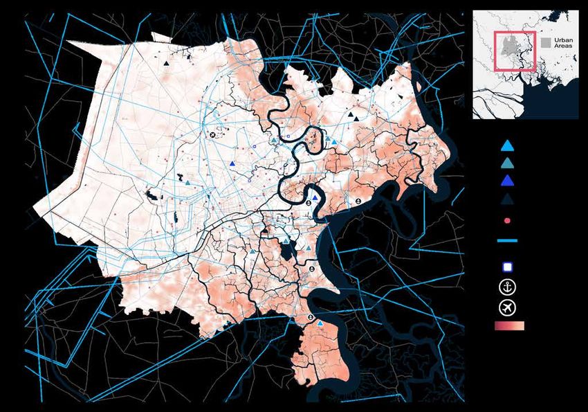
Climate risk and response | Case study: City inundation 15Case study City inundation-2
Ho Chi Minh City’s new infrastructure systems would be at immediate risk Based on RCP 8.5
from flooding in 2050.
Visualization of depths and extents of 100-year flood in 20501
Roads in Vietnam are
typically more resistant to
floods than those in many
developed countries, but
10% sustain damage in
this scenario
Tham Luon-Ben Cat
2 wastewater plant—largest
in Vietnam—likely
overflows
Informal settlement areas
in central Ho Chi Minh
City that have gradually
expanded south are
flooded
Multiple major ports are
taken offline,
representing >85% of Ho
Chi Minh City’s freight
traffic today
Planned expansion of
Hiep Phuoc Thermal
Power Station—likely to
be largest in Vietnam—
floods over 1.4m
Nha Be, a Metro stations on Flood depths Can Gio, historically one
historically poor proposed line 4 south exceed 1.5m in of the poorest parts of
part of Ho Chi Minh may become worst-hit parts Ho Chi Minh City, is
City, is flooded inaccessible of city flooded extensively1
Infrastructure Existing
Power Waste- Data Water Sub- High-voltage Train Port Airport
plant water center treatment station transmission station
plant plant line
Planned
Power Waste- Data Water Metro Metro Metro
plant water center treatment (aboveground) (overground) (underground)
plant plant
Inundation depth 0 2.8
Meters
1. It is not included in this visualization, but other academic papers have modeled severe flood risks for Can Gio.
Note: See the Technical Appendix of the full report for why we chose RCP 8.5. All projections based on RCP 8.5, CMIP 5 multimodel ensemble. Heat
data bias corrected.
Source: National University of Viet Nam; Scussolini et al., 2017; UN; Vietnam Meteorological Agency; World Bank; McKinsey Global Institute analysis
16 McKinsey Global InstituteCase study City inundation-3
In a scenario of 180cm sea-level rise, deeper and more extensive flooding Based on RCP 8.5
would flood the majority of Ho Chi Minh City.
Visualization of depths and extents of 100-year flood in 180cm sea-level rise scenario1
Airport and central
business district remain
safe due to elevation, but
central city is temporarily
cut off from surrounding
areas
City's tallest building,
$1.5 billion Landmark 81,
is cut off by flooding
Districts 2 and 7, among
city’s fastest-growing
areas and home of expat
community, severely
flooded
Bing Hung wastewater
plant, earmarked for
expansion to become
largest wastewater plant
in SE Asia, floods
Binh Chanh, a Sensitive Metro stations Flood depths
historically poor part underground on proposed exceed 2.5m
of Ho Chi Minh City, metro stations line 5 become in worst-hit
flooded extensively flood inaccessible parts of city
Infrastructure Existing
Power Waste- Data Water Sub- High-voltage Train Port Airport
plant water center treatment station transmission station
plant plant line
Planned
Power Waste- Data Water Metro Metro Metro
plant water center treatment (aboveground) (overground) (underground)
plant plant
Inundation depth 0 2.8
Meters
1. Assets in planning today with long expected design lives (such as the metro) could exist long enough to experience a 1% probability flood in a
180cm sea-level-rise scenario by the end of the century if significant action is not taken to mitigate climate change.
Note: Observations are additional to 2050 scenario. See the Technical Appendix of the full report for why we chose RCP 8.5. All projections based on
RCP 8.5, CMIP 5 multimodel ensemble. Heat data bias corrected.
Source: National University of Viet Nam; Scussolini et al., 2017; UN; Vietnam Meteorological Agency; World Bank; McKinsey Global Institute analysis
Climate risk and response | Case study: City inundation 17Case study City inundation-4
Ho Chi Minh City could experience 5 to 10 times the economic impact Based on RCP 8.5
from an extreme flood in 2050 vs today.
100-year flood effects in Ho Chi Minh City1 x Ratio relative to today High Low
Today 2050 180cm sea-level rise scenario2
Flooding Flooded area
within 23 1.5x 3x
modeled area 36
%
66
Average 0.9
flooded depth 2x 7x
within
modeled area
Meters 0.3
0.1
Impacts Real estate 18.0
damage and 6x 13x
$ billion 8.4
destruction3 1.5
Infrastructure 3.8–7.3
damage and 0.5–1.0 3x 22x
0.2–0.3
destruction3
Moderate damage to specific Widespread damage to Widespread severe damage,
infrastructure, incl infrastructure, incl ~5% of incl ~25% of metro stations,
substations, data centers, metro stations, ports, roads, 2 power stations
1 power station wastewater treatment
Knock-on 6.4–45.1
effects3 20x 104x
1.6–8.4
0.1–0.4
Possible blackouts to ~20% Partial metro closure Full metro closure affecting
of substations; possible affecting ~1 million trips; ~3 million trips; large sewage
disruption of ~15% of water sewage overflows; possible overflows; risk of full
supply blackouts to ~30% of blackout
substations
1. Repair and replacement costs. Qualitative descriptions of damage and knock-on effects are additional to previous scenarios.
2. Assets in planning today with long expected design lives (such as the metro) could exist long enough to experience a 1% probability flood in a
180-centimeter sea-level-rise worst-case scenario by the end of the century if significant action is not taken to mitigate climate change.
3. Value of wider societal consequences of flooding, with a focus on those attributable to infrastructure failure, includes loss of freight movement, lost
data revenues, and lost working hours due to a lack of access to electricity, clean water, and metro services. Adjusted for economic and population
growth to 2050 for both 2050 and 180cm sea-level rise scenarios.
Note: See the Technical Appendix of the full report for why we chose RCP 8.5. All projections based on RCP 8.5, CMIP 5 multi model ensemble.
Following standard practice, we define future states (current, 2030, 2050) as the average climatic behavior over multidecade periods. The climate
state today is defined as the average conditions between 1998–2017, in 2030 as the average between 2021–40, and in 2050 between 2041–60.
Assumes no further adaptation action is taken. Figures may not sum to 100% because of rounding.
Source: Asian Development Bank; BTE; CAPRA; CATDAT disaster database; Daniell et al., 2017; Dutch Ministry of Infrastructure and Environment;
ECLAC; EU Commission; HAZUS; Oxford Economics; People's Committee of Ho Chi Minh City; Scussolini et al., 2017; UN; Viet Nam National
University, Ho Chi Minh City; World Bank; historical insurance data; review of critical points of failure in infrastructure assets by chartered engineering
consultants; McKinsey Global Institute analysis
18 McKinsey Global InstituteIntensifying regular floods may cost 3 percent of Ho Chi Minh City’s GDP annually
by 2050
While “tail” events may suddenly break systems and cause extraordinary impact, extreme
floods will be infrequent. Intensifying chronic events are more likely to have a greater effect on
the economy, with a mounting annual burden over time (City inundation‑5). The accumulation
of small but more probable impacts will be at best a structural disadvantage to the city or,
worse, a barrier to economic growth.
Case study City inundation-5
Without further adaptation, the costs associated with floods expected to Based on RCP 8.5
occur annually in Ho Chi Minh City may grow faster than GDP.
GDP and cost impact
2019 $ billion
Ho Chi Minh City’s GDP … but the effects of flooding
is growing fast … may grow faster
Impact of flood with 100% probability
Forecast GDP per year1
Increase, 5.6x 6.9x
Today–50 320 8.7
Multiple 0.5
1.7
Infrastructure
damage
6.6
Infrastructure
60 1.3 knock-on effects
0.2 0.1 Real estate
1.0 damage
Today 2050 Today 2050
Flood impact ~2 ~3
% of GDP
1. A flood with 100% probability per year can be considered a flood with a 1-year return period—a level of flooding that can be considered with near
certainty to be the minimum that will be observed in a year.
Note: See the Technical Appendix of the full report for why we chose RCP 8.5. All projections based on RCP 8.5, CMIP 5 multimodel ensemble. Heat
data bias corrected. Assumes no further adaptation action is taken. Not to scale. Figures may not sum to 100% because of rounding.
Source: Asian Development Bank; BTE; CAPRA; CATDAT disaster database; Daniell et al., 2017; Dutch Ministry of Infrastructure and Environment;
ECLAC; EU Commission; HAZUS; Oxford Economics; People's Committee of Ho Chi Minh City; Scussolini et al., 2017; UN; Viet Nam National
University, Ho Chi Minh City; World Bank; historical insurance data; review of critical points of failure in infrastructure assets by chartered engineering
consultants; McKinsey Global Institute analysis
Today, annual flooding could be compared to a tax on the economy. Using the flood maps
and assumptions described, annual flood impacts may amount to about $1.3 billion a year,
predominantly from real estate damage. This represents approximately 2 percent of the city’s
GDP. The city has not only survived this for many years, but has continued to grow rapidly. But
regular flooding costs will continue to rise, and faster than economic activity. Ho Chi Minh City
should expect significant disruptions each year, and regular damage could reach $8.7 billion.
While real estate damage is still the largest cost, effects on infrastructure—particularly in the
form of knock-on effects—would have an increased contribution as assets such as the metro
Climate risk and response | Case study: City inundation 19become inaccessible for periods of time. Left unchecked, regular flooding could represent
an annual cost of 3 percent of GDP by 2050. More critically, the threat to the lives of citizens
of the city would also expand, as indicated by the change in flood depths and water volumes,
possibly quintupling.24
Adaptation measures in Ho Chi Minh City might require total investments comparable to
the city’s annual GDP today
Ho Chi Minh City is clearly centered on an area of high flood risk. Today, the city lives with
this level of flood risk. Tomorrow, however, impacts will grow. If infrastructure development
and wider land use policy do not adapt, by 2050 regular flooding will increase costs to the
economy, and the threat of an extreme flood could be devastating. The city’s extensive
infrastructure plans may be at odds with the changing climate that assets experience
when built.
Ho Chi Minh City has time to adapt, and other urban areas have overcome worse exposures.
With approximately 40 to 45 percent of its land area at one meter or less above sea level, the
city is topographically less exposed than the Netherlands, where approximately 50 percent of
land sits one meter or less above sea level, with a similar level of urbanization on average. The
city has many options to avert impacts because it is still early in its development journey. The
city is also already investing considerably against flooding and in 2016 committed to spending
a further $4.4 billion in flood defenses over the next five years, particularly for pumping
stations and improved drainage systems.25 Much more will be needed—the bill for Singapore,
for example, is estimated at over $72 billion.26
In this section we discuss a range of adaptation measures. Each has trade-offs, including
coverage, cost, social implications, and ease of implementation. This study does not make a
recommendation on which solutions should be pursued, as these have not been extensively
modeled; additionally, if certain adaptation measures discussed in this section may be
implemented, others may not be necessary anymore; but we encourage stakeholders to
consider the relative merits of each. Less than half of the city’s major infrastructure needed
for 2050 exists today. Many of the potential adaptation options could be highly effective.
However, it is unlikely that any single measure will be easy or without disadvantages.
Better planning to reduce exposure and risk
The city’s latest master plan is named “The Adjustment Plan” because it takes the original
1998 Urban Master Plan and adjusts for the realities of the unpredictable and largely
decentralized economic transformation the city has seen. This growth makes urban planning
for lowering flood risk challenging.
Ho Chi Minh City’s planned assets are broadly similar in their exposure to current levels of
climate risk. For asset types where geographic discretion is possible, new assets may be
better positioned than existing infrastructure. Substations built in the past ten years appear
30 to 50 percent less exposed to floods than those that are older. However, relocation
of existing infrastructure assets has not yet occurred. While shifting old assets may be
prohibitively expensive, several exposed assets are earmarked for substantial upgrades, and
plans could be reassessed in light of the latest climate predictions. In real estate, the shifting
of homes has already begun, and economic realignment toward a service economy may
reduce reliance on larger industrial real estate in more vulnerable areas.
24
This reflects merely a calculation of physical flooding conditions that can potentially lead to the threat of drowning based
on water depths and water velocities as informed by the SUFRI project of the Crue Era-New (Diaz-Loaiza et al., 2012;
Jobstl et al., 2011). Because death by flood is a highly complex phenomenon that still eludes realistic representation by
algorithms, the results of our casualties estimation should be considered as the statistical number of people that may
face life-threatening situations during the flood. While is no reliable form of accurately predicting exact numbers of
casualties, relative values can give an indication of increased risk.
25
“Ho Chi Minh City to spend $4.4bn to keep its head above water”, Global Construction Review, 30 September 2016.
26
James Crabtree, “Asia’s megacities must learn from Indonesia’s capital move,” Nikkei Asian Review, August 29, 2019
20 McKinsey Global InstituteReducing exposure to flooding entails social and financial trade-offs. Inevitably, the ability
to shift some infrastructure away from flooding affects cost and functionality. The metro is
an example of the latter—it cannot be moved without changing the population that can use
it. Other assets may also incur construction cost increases, such as substations, which may
incur increased geotechnical costs at different elevations and a need for longer lengths of
transmission cables to connect to the wider system. This leads to a complex financial and
political discussion of the benefits of building some of these assets versus the possible costs
of their exposure.
Investing in adaptation through hardening and resilience
Asset hardening may need significant investment and is currently being considered in
many forms by city leaders. Today defenses are limited, and evidence suggests that poor
maintenance hampers the effectiveness of existing dikes and drainage systems.27 The most
discussed approach to new investment is the MARD Plan Variant (a reference to an originally
much larger plan) which would create a ring dike around the most developed parts of the city.
From an infrastructure perspective, in a location with flooding as severe as that projected for
Ho Chi Minh City by 2050, our modeling suggests that this hardening measure would save
only certain infrastructure assets at the expense of others, with the average change in flood
depths across all assets being approximately zero. The measure may also amplify the impact
on the poorest areas of real estate when protecting richer areas. Even this reduced version of
the plan would come with a large estimated price tag, about $800 million.28 Larger systems
such as river and tidal barriers may provide better coverage by addressing floods at one of the
sources but will come at a much higher cost. The Soài Rap tidal barrier and Go Cong Sea Dyke
projects are such approaches; cost estimates are not available, but the projected cost for
Jakarta’s major coastal defense plans is roughly $40 billion, comparable to Ho Chi Minh City’s
current GDP.29
Natural measures may be the most cost-effective form of hardening. Mangroves currently
offer significant protection from more extreme events, reducing the height of storm surge
by 20 percent or more for every 100 meters of forest. 30 The city has made substantial
achievements in replanting 160 square kilometers in the past 35 years, bucking a trend of a
decline of 60 percent in the country over the past 70 years. 31
A more strategic approach may be to improve resilience, such as by adjusting building codes,
but this requires political leadership and infrastructure owner buy-in. Historical evidence
suggests that certain types of infrastructure built in the past eight years have demonstrated
notably greater resistance to floods than their historic counterparts. The benefits of these
improvements are economically significant. If all current and planned power stations in Ho
Chi Minh City demonstrated the characteristics of newer variants, approximately $100 million
in direct damage might be saved in a 100-year flood in 2050. The benefits from avoided
knock-on effects would add to that total, but these are more conditional on the spread of the
standard—if one critical part of an infrastructure system fails, functionality can be cut even if
all other assets are built to high standards.
While it is possible to assess benefits, understanding the costs of tightening standards
is much harder. Research from the Global Commission on Adaptation suggests the best
performing infrastructure adaptation methods can achieve cost-benefit ratios of 1:5 to 1:10. 32
27
Ho Chi Minh City Flood and Inundation Management. Final report, volume 2: IFRM strategy annex 1: Analysis of flood and
inundation hazards, FIM, 2013. Paolo Scussolini et al. “Adaptation to sea level rise: A multidisciplinary analysis for Ho Chi
Minh City, Vietnam.” Water Resources Research, 2017, Volume 53, Number 12, pp. 10841–57.
28
Paolo Scussolini, et al; Adaptation to sea level rise: A multidisciplinary analysis for Ho Chi Minh City, Vietnam, Water
Resources Research, 53, 2017.
29
Philip Sherwell, “$40bn to save Jakarta: The story of the Great Garuda,” Guardian, November 22, 2016.
30
Dasgupta, Susmita, et al. “Quantifying the protective capacity of mangroves from storm surges in coastal Bangladesh.”
PloS one 14.3 (2019): e0214079; Mark Spalding et al; Mangroves for coastal defence: Guidelines for coastal managers &
policy makers, Wetlands International and The Nature Conservancy, 2014.
31
Eric San Juan, “The evolution of Can Gio—from desert to UNESCO biosphere reserve,” Saigoneer, March 20, 2014.
32
Manish Bapna et al., Adapt now: A global call for leadership on climate resilience, Global Commission on Adaptation,
September 2019.
Climate risk and response | Case study: City inundation 21You can also read