CASE STUDY MARKERMEER-IJMEER, THE NETHERLANDS: EMERGING CONTEXTUALISATION AND GOVERNANCE COMPLEXITY - BAS WATERHOUT WIL ZONNEVELD ERIK LOUW - VERDUS
←
→
Page content transcription
If your browser does not render page correctly, please read the page content below
Case Study Markermeer-IJmeer, the
Netherlands: Emerging Contextualisation
and Governance Complexity

Bas Waterhout
Wil Zonneveld
Erik Louw

                         CONTEXT REPORT 5
To cite this report: Bas Waterhout, Wil Zonneveld & Erik Louw (2013) Case Study Markermeer-
IJmeer, the Netherlands: Emerging Contextualisation and Governance Complexity. CONTEXT Re-
port 5. AISSR programme group Urban Planning, Amsterdam.

ISBN 978-90-78862-07-9
Layout by WAT ontwerpers, Utrecht
Published by AISSR programme group Urban Planning, Amsterdam

© 2013 Bas Waterhout, Wil Zonneveld & Erik Louw. All rights reserved. No part of this publication
may be reproduced, stored in a retrieval system, or transmitted, in any form or by any means,
electronic, mechanical, photocopying, recording, or otherwise, without prior permission in writing
from the proprietor.

2                                                                  Case Study Markermeer-IJmeer, the Netherlands
Case Study Markermeer-IJmeer, the Netherlands:
                           Emerging Contextualisation and Governance Complexity

                                                Bas Waterhout
                                                Wil Zonneveld
                                                  Erik Louw

Case Study Markermeer-IJmeer, the Netherlands                                     3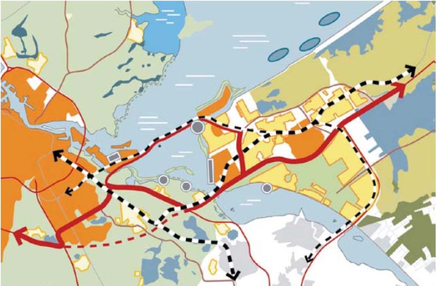
CONTEXT

CONTEXT is the acronym for ‘The Innovative Potential of Contextualis-
ing Legal Norms in Governance Processes: The Case of Sustainable Area
Development’. The research is funded by the Netherlands Organisation
for Scientific Research (NWO), grant number 438-11-006.

Principal Investigator
Prof. Willem Salet
Chair programme group Urban Planning
University of Amsterdam

Scientific Partners
University of Amsterdam (Centre for Urban Studies), the Netherlands
Prof. Willem Salet, Dr. Jochem de Vries, Dr. Sebastian Dembski

TU Delft (OTB Research Institute for the Built Environment), the Netherlands
Prof. Wil Zonneveld, Dr. Bas Waterhout, Dr. Erik Louw

Utrecht University (Centre for Environmental Law and Policy/NILOS), the Netherlands
Prof. Marleen van Rijswick, Dr. Anoeska Buijze

Université Paris-Est Marne-la-Vallée (LATTS), France
Prof. Christian Lefèvre, Dr. Camille Gardesse

University of Liverpool (The Heseltine Institute for Public Policy and Practice), United Kingdom
Prof. Alan Harding, Dr. Nicola Headlam

Professional Partners
DG Ruimte en Water Ministerie van Infrastructuur en Milieu, Provincie Noord-Holland, Provincie
Flevoland, Stadsregio Amsterdam, Project Management Bureau Gemeente Amsterdam, Noord-
waarts Gemeente Amsterdam, Hoogheemraadschap De Stichtse Rijnlanden, KWR Watercycle Re-
search Institute, Institut d’Aménagement et d’Urbanisme Île-de-France, Manchester’s Commission
for the New Economy

4                                                                   Case Study Markermeer-IJmeer, the Netherlands
Contents

            Executive summary                                                    6

        1 Introduction                                                          10

        2 Main regulatory frameworks                                            18

        3 Preliminary struggles paving the road towards contextualisation
          (1960–2005)                                                           30

        4 Getting attention of the National Government (2005–2010)              41

        5 Focusing on TBES within the RRAAM programme (2010–now)                57

        6 Conclusion: mechanisms for contextualisation                          65

            Annex: overview of organised major stakeholders Markermeer-IJmeer   70

            References                                                          74

Case Study Markermeer-IJmeer, the Netherlands                                    5
Executive summary

The key issue in the Markermeer-IJmeer is developing the so-called TBES (or toekomst bestendig
ecologisch system), which translates as a ‘robust ecological system’. A TBES is deemed the best
option to cater for 1) the demands the Natura 2000 framework and (to a lesser extent) Water
Framework Directive and 2) space, literally and figuratively, for developing a 60,000 additional
houses in the city of Almere, a transport connection linking between Almere and Amsterdam as
well as for a variety of lower scale demands such as recreation and enlarging marinas at the
North Holland coast.

With the Markermeer-IJmeer being designated as Natura 2000 area the large infrastructure and
urban development projects for this area should meet with demanding criteria from the Birds and
Habitat directives as well as with those of the Water Framework Directive. While it is quite a chal-
lenge already to deal with the ‘significant effects’ that these projects will sort, the case becomes
even more complicated due to the Autonomous Negative Trend (ANT) that the ecological system
of the Markermeer-IJmeer is experiencing. Being an artificial lake that originally was planned to
become a polder, the ecological system is rather young and dynamic. The negative trend, howev-
er, is causing an ecological situation that does not meet anymore the minimum requirements of
Natura 2000. Also, with a view to the longer term, the requirements by the Water Framework
Directive for 2015 and 2027 will not be met either (see Chapter 2). So, even without the plans for
major urban and infrastructure development in the IJmeer, action is needed to make sure that
the area complies with the demands of EU directives.

Chronology
First ideas for what now is referred to as TBES have emerged around 2004. It was around this
time that the formal planning process for IJburg 2, an Amsterdam housing location on artificial
islands in the IJmeer as well as plans for Almere were prepared. Both developments would heavily
impact on the IJmeer lake, which had the status of a special protection zone under the Birds di-
rective since 1994, and its environmental and ecological qualities. Also, given the experience of
strong but fruitless opposition from environmental organisations against IJburg 1 fresh in mind, a
number of organisations, civic as well as public, decided the time had come to sit around the table
and develop a joint vision for the lake (see Chapter 3). By 2005 this resulted in the Visie IJmeer
which was endorsed by 7 civic and public organisations.1 A main message of the vision concerns
the necessity to invest in the green-blue qualities of the IJmeer as a precondition for a sustainable

1
 This concerns NGO’s Natuurmonumenten, Staatsbosbeheer and ANWB, the municipalities of Amsterdam and Almere
and the provinces of North Holland and Flevoland (with RWS as advisor).

6                                                                       Case Study Markermeer-IJmeer, the Netherlands
solution for the decreasing ecological trend and further development in the area. It is this princi-
        ple that forms the basis for the future TBES.

        In August 2006 the national government asks the regional stakeholders in the so-called North-
        Wing letter, to further develop a vision for the future development of the Markermeer-IJmeer area
        including Almere and the new infrastructure development. A key element is to address the ecolog-
        ical situation. A research programme is funded to this end. In parallel preparations are started to
        designate the area as part of a larger green-blue delta, which includes the Green Heart. In 2009
        the area, which already was designated a protection zone under the Birds Directive is formally
        indicated as Natura 2000 area.

        The process went through a variety of stages which can be characterised by the names of national
        policy programmes, acting as meta-governance environments. Subsequently these are the Pro-
        grammatic Approach North Wing, from 2006 to 2007, the Programme Randstad Urgent (PRU)
        from June 2007 to May 2010 and the Programme RRAAM from 2009 onwards. After a change in
        government in 2007 much of the content of the North-Wing letter was continued under the new
        Programme Randstad Urgent (PRU). One of the PRU projects was Toekomstagenda Markermeer-
        IJmeer (TMIJ) or Future-programme Makermeer-IJmeer with the aim to develop a development
        perspective on the area. This resulted in 2009 in the Toekomstbeeld Markermeer-IJmeer: the
        Future Vision Markermeer-IJmeer. It is this vision that coins the concept TBES.

        The Toekomstbeeld Markermeer-IJmeer document needs further elaboration and the vehicle for
        this is found in the (R)RAAM programme. Much more than in previous programmes is the urgency
        of a TBES is now recognised by the national government. This RAAM-brief has the status of gov-
        ernment policy. TBES is one of the three core ambitions alongside housing/work (60,000 houses
        in Almere) and accessibility (connection between Almere and Amsterdam). A complete TBES re-
        quires an estimated investment of around €1bn. Hence, one objective of RRAAM is to develop
        more cost-efficient alternatives for TBES. The Werkmaatschappij Markermeer-IJmeer (WMIJ),
        consisting of representatives of the ministries of I&M and EL&I and the provinces of Flevoland and
        North Holland, is commissioned with this task.

        As part of the efforts to reduce costs the WMIJ organised input from private parties. On the basis
        of these outcomes and by combining several elements of the reports, WMIJ constructs three TBES
        alternatives against cost reductions of some €200m. Based on these three alternatives and a
        fourth alternative developed by Natuurmonumenten (the Marker Wadden), which is partly spon-
        sored by a substantial fund from the Postcode Lottery, and negotiations between the national and
        provincial governments, the national government develops a so-called RRAAM-Structure vision.
        This structure vision, a formal planning instrument, will further guide developments in the area.
        At this moment (August 2013) there is €45m available to develop the Marker Wadden as the first
        part of TBES. A draft land-use plan for this project was published on 5 August 2013.

        Uncertainties and challenges
        Although the TBES concept sounds pretty straightforward, it is surrounded by a number of uncer-
        tainties or challenges. Uncertainties relate to technical, financial, legal and, in relation to the latter
        in particular, process aspects. Technical uncertainties relate to the various components of which a

Case Study Markermeer-IJmeer, the Netherlands                                                                  7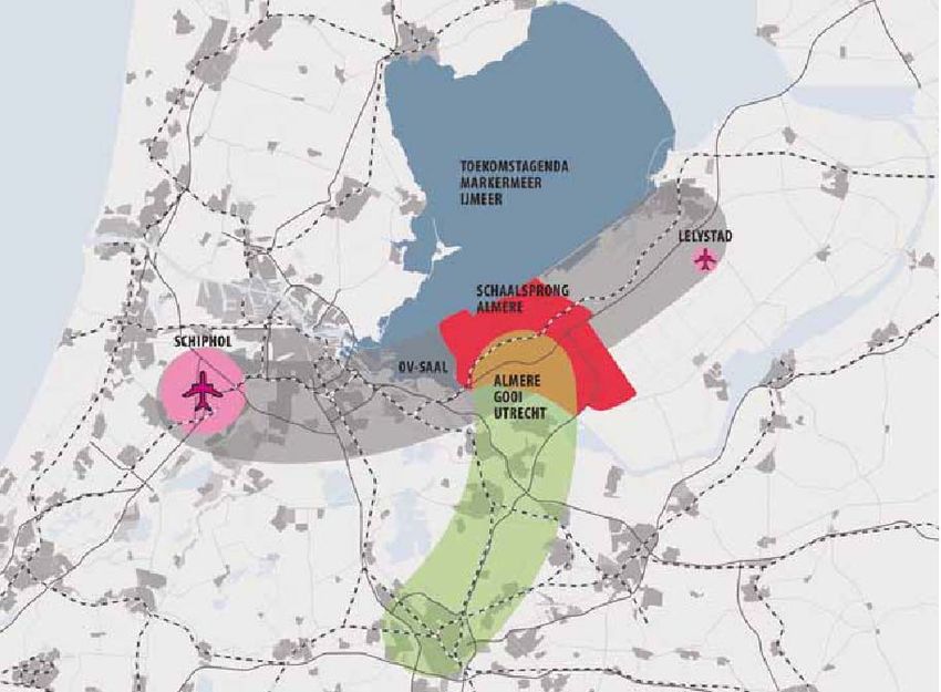
TBES can consist and what is effective in which location. Financial uncertainties relate to budgets,
phasing and stakeholder responsibility as obviously a TBES requires some serious investment
initially estimated at an amount around €1bn to be brought down during the process to amounts
ranging from €350m to €800m, depending on the alternative. Legal uncertainties relate to the
interpretation and application of the Water Framework Directive and in particular the Birds and
Habitat directives, whose interpretation in the Netherlands is notorious for its complexity. A key
question during the process is whether the solutions are ‘EU-proof’. As regards process uncertain-
ties the challenges are to involve all relevant stakeholders, of which there are a small hundred, to
deal with the national and regional policies and programmes that run in parallel and to raise as
much as possible support from society. The latter is relevant in a sense that avoiding legal protest
is the easiest way to make the plans ‘Council of State proof’. Moreover the Council of State puts
much emphasis on the quality of the process when assessing a legal dispute.

A complicating factor as regards the process and governance situation that can be described in
terms of multi-level, pluri-centric and meta-governance is that there is no clear single problem
owner for the area. The result is that over time the central focus and the ownership of the project
shifts among the various stakeholders. Also there is the somewhat difficult balance between the
national government on the one hand and the regional stakeholders on the other, translating eve-
ry now and then in an unclear picture of responsibilities and competencies.

Contextualisation mechanisms
– (Re)framing - Perspective change: a nature inclusive approach: In terms of contextualisation it
    can be observed that a number of mechanisms are used. The TBES concept itself can be re-
    garded a first step in the contextualising of regulation as it addresses multiple regulations, alt-
    hough in particular Natura 2000. Regardless whether it is regarded an expensive and perhaps
    overdone solution or as a smart efficient catch all solution, it is clear that the development of a
    robust ecological system solves a number of regulatory issues and benefits a wide range of
    stakeholders. As such the perspective change by taking a ‘nature inclusive approach’, a con-
    cept borrowed from a discussion in the Netherlands on local and regional development starting
    from the perspective of nature and environment rather than treating this as a rest category,
    has been important for contextualising regulation.

– Governance and process: A second mechanism that is important for contextualisation concerns
    the governance dimension. Because of the scale, the soft space characteristics of the area and
    the lack of a single problem owner, governance is a key element to contextualise and to inter-
    pret the several policy alternatives. In this sense the TBES concept or nature inclusive ap-
    proach proofs to be beneficial, too, as it helps to open the floor to a wide range of stakehold-
    ers. In particular the scale of the TBES, spanning the whole Markermeer-IJmeer area, and the
    promise of the concept in terms of solving the administrative and practical burden that Natura
    2000 regulation (as well as other regulation) casts on initiative takers for more economically
    oriented projects by creating more flexibility through creating an ecological surplus results in
    an agenda that can attract support, be it implicit or explicitly. Turning the support into full
    commitment has proven to be a difficult step, but the importance of having an agenda that
    seems to hold something in it for everybody can hardly be underestimated.

8                                                                     Case Study Markermeer-IJmeer, the Netherlands
– Programming approach: A third and more direct way of contextualising Natura 2000 regulation
            concerns the earlier mentioned programming approach. A programming approach differs from
            usual mitigation or compensation measures in a sense that it comprises of a number of
            measures that are interrelated in time and effectiveness. Judging several advisory reports
            commissioned by the Markermeer-IJmeer working association,2 there are a number of prob-
            lems in terms of its legal assessment and whether a programming approach can mitigate or
            compensate for economic development. First, with a plan horizon located somewhere between
            2035 and 2040, the promise of the programming approach, or of the TBES as such, lies in a
            quite distant future. This means that no certainty can be given as regards its effectiveness and
            indeed implementation. Second, the initiative taker for economic or urban development pro-
            jects is not the same as the bodies that implement the TBES. A third problem is related to the
            timing and phasing and whether it is allowed to embark on urban development projects envis-
            aged in the RRAAM context before or at the same time of implementing mitigating or compen-
            satory measures.

        Due the economic crisis this last problem seems to be of little importance for the implementation
        and development of the TBES. New urban developments are almost stopped, whereas funding for
        the first parts of TBES are available.

        2
          A. Freriks, Nader Advies juridische strategie RRAAM, 27 August 2012; AKD, Juridische strategie structuurvisie Am-
        sterdam-Almere-Markermeer, 21 August 2011.

Case Study Markermeer-IJmeer, the Netherlands                                                                             9
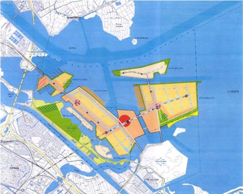
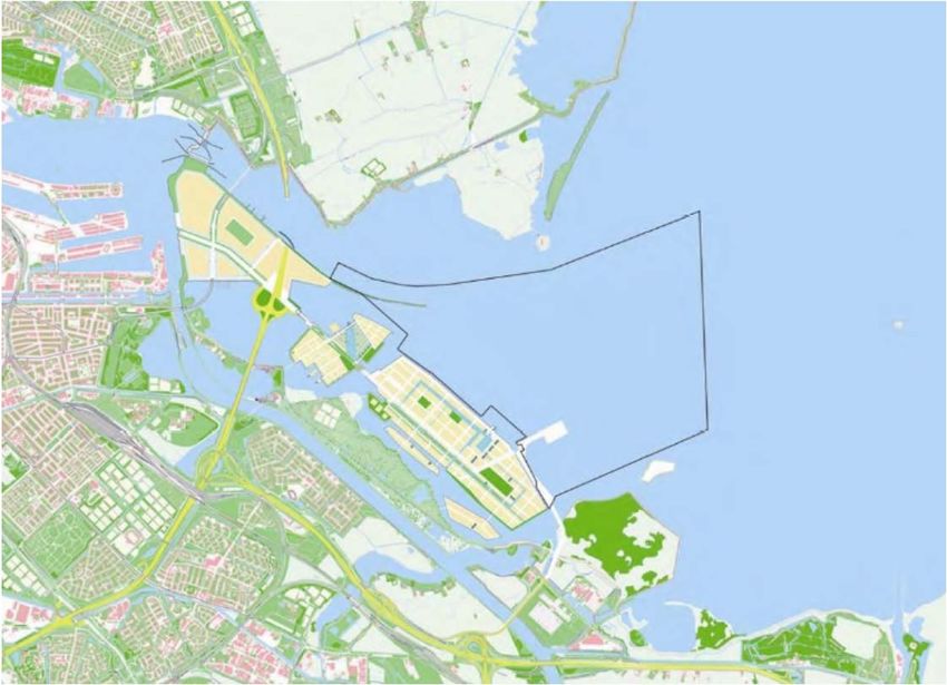
1 Introduction

Key characteristics of the Markermeer-IJmeer
The Markermeer-IJmeer3 concerns a lake of some 30 by 25 kilometres in the centre of the Neth-
erlands. In spite of its name which seems to indicate that we are dealing with two lakes, the
Markermeer and IJmeer in reality form one water system, with no clear border between the two
lakes (see also Fig. 1).4 The case study centres on a project aiming to developing a TBES
(toekomstbestendig ecologisch system) for the Markermeer-IJmeer area. TBES literally translates
as a ‘future proof ecological system’, but throughout the report we will simply refer to it as robust
ecological system. Such a system aims to create possibilities for some major urban development
projects within the area without doing further damage to its environmental and ecological quali-
ties. Currently the ecological conditions of the Markermeer-IJmeer do not meet the requirements
related to the area’s Natura 2000 status or those demanded by the EU Water Framework Di-
rective. Moreover, the ecological situation is prone to a so-called Autonomous Negative Trend
(ANT) (see also Box 1 below). So, even without urban development or any activity at all the eco-
logical system will further degrade.

Being located in the Amsterdam Metropolitan Area, the Markermeer-IJmeer area is subject to
pressure from several desired and planned developments. In particular the enlargement of Almere
with 60,000 new houses, this is commonly referred to as a ‘scale jump’. A substantial part of the
houses may be realised offshore outside the polder dykes in the IJmeer and Markermeer. In order
to guarantee accessibility new infrastructure connecting Schiphol, Amsterdam, Almere and Le-
lystad (OV-SAAL) is planned (see Schaalsprong Almere and OV-SAAL in Fig. 2). All developments
will directly impact on the ecological quality of the protected Markermeer-IJmeer.

These projects are developed in mutual coordination within the so-called RRAAM programme,5 a
programme between the national government and regional stakeholders including the provinces
Flevoland and North Holland, concerning the development of the Amsterdam, Almere and Mark-
ermeer-IJmeer region. The various RRAAM projects are closely related with each other (amongst
other by means of the RRAAM organisation that prepares them) and due to the Natura 2000 sta-
tus of the Markermeer-IJmeer all are somehow dependent on the quality and robustness of the
ecological system, or in other words developing a TBES.

3
  Note that the Dutch word meer translates as lake in English. Throughout the report we will refer to the Markermeer-
IJmeer by its Dutch name without further translation.
4
  In fact also the Gooimeer and Eemmeer make part of this closed water system.
5
  RRAAM refers to Rijk-Regioprogramma Amsterdam-Almere-Markermeer and concerns a programme in which the
central government cooperates with regional stakeholders.

10                                                                             Case Study Markermeer-IJmeer, the Netherlands
Fig. 1. Reference image for the case study area. Source: Ministerie I&M, 2009: 2

        Fig. 2. RRAAM projects in overview. Source: Samenwerkingsverband Markermeer-
        IJmeer, 2009: 11

Case Study Markermeer-IJmeer, the Netherlands                                              11
Box 1. Current ecological situation in the Markermeer-IJmeer The Markermeer-IJmeer lake is an artificial lake created in 1976 with the construction of the Houtribdijk (or Markermeerdijk) between Lelystad and Enkhuizen. It was never intended to be a lake at its current the large scale as the objective was to reclaim another polder from the lake in this area: the Markerwaard polder. However, due to a lack of financial means and increasing envi- ronmental concern, the support for developing the Markerwaard polder faded. Ultimately, the plan-reservation for the Markerwaard has formally been abandoned in the National Spatial Strate- gy of 2006. In the meantime the IJmeer and Markermeer lakes, which basically form one water body, have been appointed as Special Protection Zone (SPA) under the Birds directives in 1994 and 2000 respectively. Some parts of the area, near the Muiden coastline and the Gouwzee, also have been appointed as Special Areas of Conservation (SAC) under the Habitat area. Since 2009 the whole area is formally indicated as a Natura2000 area. As a result of not developing the Markerwaard polder a new, unforeseen, ecological system has come into existence, something for which the lake never had been designed. This becomes clear amongst others from the design of the dikes surrounding the lake, which are hard and steep, allowing no vegetation to grow. The lake is around 4 meters deep at maximum with a bottom largely covered by a layer of silt and sludge which easily whirls up in modestly windy conditions (as from 3 or 4 Beaufort). As a result the water is generally muddy (see Fig. 3 and see the photo on the cover of this report which shows the Houtribdijk seen from the North-Holland side and clearly shows the difference in water clarity between the adjacent IJsselmeer and murky Marker- meer). This prevents vegetation to grow and clear water species, such as mussels and certain types of fish, to live. The latter, including waterplants (in particular a particular type of weeds [kranswieren]) serve as food for several of the protected birds in the area, whose populations are in decline. If nothing is done the ecological system will degrade further, a situation that is referred to as the Autonomous Negative Trend (ANT). While the RRAAM programme started only in 2009, there is quite a long and complex history of events preceding it. In 2009 the TBES concept was already developed and elaborated to quite an extent. The RRAAM programme merely forms a meta-governance environment in which the TBES could be further elaborated. Before RRAAM there have been other such meta-governance frame- works, such as the national Programme Approach North Wing as from 2006 and the Programme Randstad Urgent that facilitated the work on the TBES. Before that period the national govern- ment has never been involved and it have been exclusively regional stakeholders that felt a need to develop a vision on the IJmeer and Markermeer. This process started around the year 2000 when Almere developed plans for major urban extension, partly within the IJmeer. As chapter 3 points out the regional visioning followed on an earlier period characterised by difficult plan devel- opment and fierce opposition of environmental and nature pressure and lobby groups around the new Amsterdam district IJburg located on a number of new islands built in the IJmeer. Whereas in this period in the 1990s public and civic stakeholders were at loggerheads, in hindsight it paved the road towards contextualisation and the TBES concept. 12 Case Study Markermeer-IJmeer, the Netherlands
Fig. 3. Murky waters of the Markeermeer-IJmeer hydrological compartment.
        Source: WMIJ, 2012: 11

        The TBES approach is innovative to Dutch standards in a sense that it departs from the more
        commonly adopted approach to mitigate or compensate for lost and affected nature under the
        Birds and Habitat Directive regime. TBES does not aim at maintaining a status quo but aims for
        an ecological situation, which in terms of quality will go far beyond minimal ecological require-
        ments. The idea is that the scale and robustness of ecological system can easily absorb the nega-
        tive impacts of urban and infrastructure development projects, as well as a variety of smaller
        scale impacts, mainly related to recreation and leisure, along the North Holland coast.

        The development of the ecological system itself is a complex affair surrounded by many uncer-
        tainties. In a technical sense it is uncertain which elements will be effective in which shape and
        location. Also it is unclear how various elements of the TBES act together. Fig. 4 shows the base-
        line TBES concept and its various elements of July 2012. In the meantime the concept has been
        further elaborated, as will become clear in chapter 4.

Case Study Markermeer-IJmeer, the Netherlands                                                                13
Fig. 4. TBES concept and its components (Baseline Alternative, July 2012). Source:
Samenwerkingsverband Markermeer-IJmeer, 2009: 27
Research question
The central research question of the Context project is:
How can central regulation be matched with interactive local policies in such a way that it
enables legitimate and effective strategies of collective action with regards to sustainable
development in areas of urban transformation?
When applying this question to the Markermeer-IJmeer case it can be noted that indeed this
question is relevant. Central regulation in this case predominantly refers to the EU Bird and Habi-
tat directives and the Water Framework Directive. Interactive local policies can be understood as
the process started around the year 2000 of the developing the IJmeer perspective to the
Toekomstbeeld Markermeer-IJmeer (2009) and the current cooperation in the context of the
RRAAM programme resulting in the RRAAM structure vision in 2013.
How does central regulation impact upon the regional solution finding in the case of the Marker-
meer-IJmeer? This first of all directs us to the substantive dimension of proposed solution and
collective action. To what extent is the contents of policy proposals steered by central regulation
and how is this experienced by local stakeholders? Second, there is a need to look in more detail
to the central regulation and its specific characteristics. Obviously, EU regulation should first be
transposed, implemented and enforced at the national level, before taking effect at the local level.
14 Case Study Markermeer-IJmeer, the NetherlandsSo, how is this process managed, to what extent are the national regulation and Dutch nature
policy concepts comparable to EU concepts and regulation and what are consequences in terms of
the applicability in Dutch ecological conditions? A final question is what mechanisms have been
used and developed to actually synchronise the demands of the central regulation with those of
the region?
In this sense the report is inspired quite closely by the end-users that are involved in this case
(three key stakeholders: province of Flevoland, province of North Holland and ministry of Infra-
structure and Environment). The end-users’ statement indicates clearly the main issues as per-
ceived by the stakeholders. Also it points to some directions in which it is aimed to deal with cen-
tral regulation by means of contextualising through local and regional governance solutions.
End users statement
The end users of the case study Markermeer-IJmeer are:
– Province Flevoland (represented by Dennis Menting
– Province North-Holland (represented by Anja Ooms)
– Ministry of Infrastructure & Environment (represented by Adriaan van Doorn)
The statement has been developed by the end users.
The vast area of the Markermeer-IJmeer (approx. 700 km2) is characterised by a number of
complex and interrelated problems in which a large number of cooperating actors is involved as
well as a very large number of potential stakeholders. Hence the Markermeer-IJmeer meets a
number of criteria to qualify as an area development project. The Committee for Environmental
Impact Assessment describes area development as follows (CMER, 2010):
“Area development concerns challenges of a complex territorial, financial, multi-level and
cross-sectoral nature. The challenges relate to a large but generally clearly demarcated ar-
ea and have a long-term character. Several public, private and civic actors are involved as
well as many owners, users and otherwise affected stakeholders. There are several alterna-
tive solutions possible.” [translation by the authors]
Key issues in the area concern:
– Bad and worsening ecological conditions. Even without (possibly) disturbing developments
(such as off-shore housing and marina development) this trend continues. Murky water is a
key reason and to a high extent a result of (unforeseen effects of) measures taken in the past
such as the compartmentalisation of the IJsselmeer as a result of the Houtribdijk (limiting the
supply of nutrients by the river IJssel), hard shores (preventing purifying vegetation to grow)
and whirling effects in the water (current and billow). Because of the murky water specific wa-
ter plants and the zebra mussel cannot grow sufficiently and in due turn specific (threatened)
birds cannot forage and reduce in numbers.
Case Study Markermeer-IJmeer, the Netherlands 15– The Markermeer-IJmeer has been designated as Natura 2000 area. Therefore it is subject to
the Birds- and Habitat directives and the Dutch legislation in which these directives have been
transposed, in particular the nature protection act (Natuurberschermingswet – Nbwet).
– The legislative framework together with jurisprudence imposes important preconditions to the
further development of the area. This includes amongst others: off shore development (Al-
mere, IJburg); recreation in combination with capacity increase of marinas; the (possible) de-
velopment of new infrastructure between Almere and the North Wing; the (eventual) develop-
ment of new wind turbine farms in order to comply with centrally agreed national6 (but EU in-
spired) wind energy objectives. Depending on the final decision on its route a 380 kV electric
cable between Ens and Diemen can be added to this. The decision on its necessity is taken at
the national level, to which local and regional have to comply.
– The controversy of a variety of land claims, whereas ‘doing nothing’ will be counterproductive
for reaching a solution for the ecological situation in the area (see point 1).
The issues above are closely related to location of the Markermeer-IJmeer in an urban structure
that will house some 1,5 million inhabitants. By means of the Werkmaatschappij Markermeer-
IJmeer and the RRAAM (Rijk-Regioprogramma Amsterdam-Almere-Markermeer) it is aimed to
integrate the spatial developments that result from this location with measures to improve the
ecological conditions in the area by means of project envelopes or financial equalization. Apart
from political and societal controversy as regards particular dossiers (such as off shore develop-
ment, wind turbines in the Markermeer and infrastructure through or under the IJmeer) this de-
velopment is compromised by issues relating to (an inflexible use of) juridical regimes and gov-
ernment hierarchy.
Nature protection regulation imposes important preconditions on future developments (which to
some extent also counts for the Water Framework Directive). No significant disturbing develop-
ment may occur and, if so, they should in the first place be mitigated and, if this is not sufficient,
be compensated. With regard to the latter the hard condition is that there is no alternative possi-
ble and that there are compelling reasons of national importance. The Natura 2000 status of the
area has led to quite some debate between local/regional authorities and nature protection organ-
isations. At the same time examples from practice (IJburg, Maasvlakte 2, Waterfront Harderwijk)
show that it is possible to arrive, in cases after consultation of the European Commission, at ac-
ceptable solutions for all. This can be characterised as a new multi-level governance model that
we would like to explore further. Some related questions: what are fail and success factors, juridi-
cal, content wise and process/organisational? What can TBES learn from this?
– With regard to the latter: as an alternative the region has developed within the Toekom-
stagenda Markermeer-IJmeer (TMIJ) cooperation a different legal strategy (the so-called pro-
gramming approach). This concerns creating space for development by developing a ‘future
proof’ ecological system, or TBES (toekomstbestendig ecologisch system), which robustness is
able to absorb the effects of urban development. The operating company Markermeer-IJmeer
(WMIJ – Werkmaatschappij Markermeer-IJmeer) has checked this strategy by A. Freriks, pro-
fessor in legal studies, and an advisory group. This led to the formulation of a programme of
requirements. The EU in principal has given its consent, but in the Netherlands the ministry of
Economy, Agriculture and Innovation casts serious doubts. This implicates that in the search to
6
The decisions on implementation are made at the national level. But agreements at the EU level, in particular Di-
rective 2009/28/EC on renewable energy, are the main source.
16 Case Study Markermeer-IJmeer, the Netherlandscontextualisation it might be found that there are differences in interpretations and opinions
between different levels of government and legal frameworks. Put in different words: a sys-
tems approach (with Markermeer-IJmeer in totality being the system) is new with the key
challenge becoming its legal legitimacy. Experiences with similar programming approaches in
the Netherlands with regard to air quality and nitrogen may be interesting in terms of compari-
son. A key question in this regard is the extent to which such programming approaches are
flexible in their implementation.
– A second governance model concerns the area-oriented approach which aims for improving
ecological conditions, nature compensation and mitigation at a higher level of scale, combined
with financial equalisation between projects. Within this context it is considered to use the rev-
enues of sand extraction in the area itself for nature restoring. Horizontally, at the level of the
regions, there is some tension as regards the way several stakeholders frame the situation.
Combined with the previous point: what are the legal requirements for optimising the ap-
proach – including the phasing and securing of investments in nature – and the search for
larger opportunities for urban development.
– The central government will re-evaluate the ecological main structure policies including its
budgets. In general the regional and local levels are confronted with centrally decided budget
cuts as well as negotiated (in the context of the MIRT programme) financial conditions for area
development. What strategies can be developed at the level of the area itself to deal with the-
se changing financial conditions?
Reading guide
The remaining of this report consists of 5 Chapters and an Annex. Chapter 2 introduces the main
regulatory frameworks, with a focus on EU-directives and Dutch flood control regulations which
apply to the Markerkeer-IJmeer.
In chapter 3 the history of the case area is analysed until 2005 and mainly deals with the plans,
discussions and development of IJburg, the residential neighbourhood build on an artificial island
in the IJmeer. During this period and especially after the referendum in 1997 about de develop-
ment of IJburg, the first signs of contextualisation began to appear.
Chapter 4 deals with the complex governance processes in which the contextualisation of Natura
2000 regulation by means of the TBES concept did develop. It analyses the increasing number of
stakeholders under different governance programmes. It shows how provincial and national gov-
ernments got involved.
Chapter 5 focuses on TBES within the RRAAM-programme, which seems the programme in which
de development of TBES will start. In chapter 6 the key dimensions of contextualisation in the
Markermeer-IJmeer area are discussed.
Case Study Markermeer-IJmeer, the Netherlands 172 Main regulatory frameworks
A main characteristic of the Markermeer-IJmeer case is the deep influence of EU environmental
legislation. Apart from the EU treaties the European Union knows three types of legally binding
tools: regulations, decisions and directives. Regulations and decisions are binding in their entirety,
the difference is that the former have a general application while the latter specify those to whom
they are addressed and shall be binding only on them. Directives bring with them the obligation to
produce results but how to achieve this in a legal sense is up to member states. Article 288 of the
(consolidated version of the) Treaty on the Functioning of the European Union describes this as
follows:
‘A directive shall be binding, as to the result to be achieved, upon each Member State to
which it is addressed, but shall leave to the national authorities the choice of form and
methods.’7
EU (environmental) directives contain many procedural requirements, like the obligation to report
and submit plans to the Commission or to involve the Commission in certain decisions which
might be taken by member states but this does not relate to the legal transposition of the di-
rective in question into national law.
The deadline for transposition is always explicitly mentioned in any EU directive. Member states
often – for a variety of reasons – do not comply with such a deadline. This can result in an official
notice of default by the Commission eventually followed by a condemnation by the European
Court of Justice. This happened to the Netherlands in relation to the Bird as well as the Habitat
directive. If deadlines are not met (or in the case of an improper transposition) EU directives di-
rectly apply to a national territory. All competent authorities on all administrative levels within a
member state are obliged to apply the directive in question to their territory. This weighs heavily
on the (judicial) expertise and adaptability of especially the lower levels of member state admin-
istration as in the early stages of application of a EU directive there will be no or hardly any expe-
rience and jurisprudence. At the same time – this counts for the Netherlands especially – there is
a culture of bringing objections to courts of justice, for a great deal stimulated by the fact that
Dutch courts tend to decide on cases rather speedily compared with many other EU member
states (VROM-raad, 2008).
7
Consolidated versions of the Treaty on European Union and the Treaty on the Functioning of the European Union,
Official Journal of the European Union, C 83, Volume 53, 30 March 2010, p. 82, http://eur-
lex.europa.eu/LexUriServ/LexUriServ.do?uri=OJ:C:2010:083:0047:0200:EN:PDF (accessed 19 March 2013).
18 Case Study Markermeer-IJmeer, the NetherlandsBird Directive
The 1979 Bird Directive8 is the oldest form of EU nature legislation. The legitimisation of the di-
rective is explained as follows:
‘The species of wild birds naturally occurring in the European territory of the Member States
are mainly migratory species. Such species constitute a common heritage and effective bird
protection is typically a trans-frontier environment problem entailing common responsibili-
ties. […] The conservation of the species of wild birds naturally occurring in the European
territory of the Member States is necessary in order to attain the Community’s objectives
regarding the improvement of living conditions and sustainable development.’
The core of the directive is formed by article 3, which in essence follows an entirely territorial
approach:
‘Member States shall take the requisite measures to preserve, maintain or re-establish a
sufficient diversity and area of habitats […]. The preservation, maintenance and re-
establishment of biotopes and habitats shall include primarily the following measures:
a creation of protected areas;
b upkeep and management in accordance with the ecological needs of habitats inside and
outside the protected zones;
c re-establishment of destroyed biotopes;
d creation of biotopes.’
Interestingly in the Dutch version of the Bird Directive ‘management’ (see b) is translated as
‘ruimtelijke ordening’ or spatial planning. Although the European Union does not have a spatial
planning competence nevertheless by demanding that member states should carry out (proper)
spatial planning in order to protect species and their habitats one can conclude that indirectly the
European Union acquired such a competence.
Also in another sense the Bird Directive implies a kind of spatial planning: due to the fact that
many birds tend to migrate and/or rest and feed at different locations the required ‘special con-
servation measures’ need to be coordinated ‘with a view to setting up a coherent whole’.9 This
coherent whole is currently known as an ecological network or – since the Habitat Directive –
simply Natura 2000.
The Bird and Habitat directives are often discussed together but the effects and implications are
different up to a certain level. On the whole the Bird Directive is considered as more stringent
because the Habitat directive opens the possibility for certain exceptions towards the protection of
species and their habitats in cases of ‘imperative reasons of overriding public interest, including
those of a social or economic nature’. So, under certain but very strict conditions, the generic goal
of nature conservation in relation to specific species and habitats could be adapted in relation to
the local and regional context (see below). The Bird Directive is much more restricted in this
8
Here we refer to the 2009 codified version: Directive 2009/147/EC of the European Parliament and of the Council of
30 November 2009 on the conservation of wild birds (codified version) Official Journal of the European Union L 20,
pp. 7–25.
9
Ibid. p. 7.
Case Study Markermeer-IJmeer, the Netherlands 19sense. First member states do not have much discretionary power to identify protected areas.
They are obliged to select the most appropriate areas. According to jurisprudence only ornitholog-
ical criteria count (Beijen, 2010: 174). The possibility to reduces the size of protected areas once
they have been designated are very small. This is only possible in those cases where the interests
are more important than ecological interests. Reducing flood risks may count but certainly not
economic or recreational reasons. According to Backes (2000: 11, in Beijen, 2010: 176) such a
limitation towards competences to balance interests – which forms the heart of spatial planning,
at least in the Netherlands – is rather exceptional. On top of that the European Commission does
not need to show that a certain areas should have been designated. If the Commission can show
that a member state has designated far too few protected areas this will suffice to be sentenced
by the European Court of Justice. This happened to several member states, including the Nether-
land (Beijen, 2010: 176).
The transposition and actual implementation of the Bird Directive has been rather problematic in
many Member States (Van den Brink, 2004: 66). National legislators but also policy makers often
grossly overestimated the level of flexibility and regulatory freedom the directive offered. The
Dutch national state has been condemned by the European Court of Justice for (seriously) breach-
ing the deadline for transposition of the directive, which was set for 1983. Eventually the directive
was translated into the Flora and Fauna Act and the 1998 version of the Nature Conservation Act.
Every three years, starting from 7 April 1981, member states shall forward to the Commission a
report on the implementation of the national provisions taken under the Directive.
Habitat Directive
The 1992 Habitat Directive10 speeded up nature conservation policies of the European Union. Key
objective is the realisation of an ecological network of protected zones known as Natura 2000.
Member states have the obligation to designate so called special areas of conservation. The areas
designated under the Bird Directive will be part of Natura 2000 as well.
The most important article of the Habitat Directive is article 6 which can be summarized as fol-
lows:
Member states have a general protection obligation meaning that for the special areas of
conservation, Member States shall establish ‘the necessary conservation measures’ which
correspond to the ‘ ecological requirements’ of the natural habitat types and species, both
explicitly and exhaustively listed in two annexes:
‘Member States shall take appropriate steps to avoid, in the special areas of conservation,
the deterioration of natural habitats and the habitats of species as well as disturbance of
the species for which the areas have been designated, in so far as such disturbance could
be significant in relation to the objectives of this Directive.’
10
Council Directive 92/43/EEC of 21 May 1992 on the conservation of natural habitats and of wild fauna and flora,
Official Journal of the European Union, [Consolidated Version], 1992L0043— EN— 01.01.2007 — 005.001— 1;
http://eur-lex.europa.eu/LexUriServ/LexUriServ.do?uri=CONSLEG:1992L0043:20070101:EN:PDF (accessed 17 March
2013).
20 Case Study Markermeer-IJmeer, the NetherlandsThe obligation to avoid any deterioration is not limited. Any deterioration, whatever the cause,
should be either avoided or restored. This also counts for changes resulting from for instance cli-
mate change or natural fluctuations in the population size of a particular population (Beijen,
2010: 187). At least in the Netherlands this has caused quite a lot of discussion. According to
some there is a underlying conception of nature and ecological qualities which is rather static
while nature, even in good condition, never is.
In terms of effects on spatial plans and spatial development paragraph 3 of article 6 is of utmost
importance. We have underlined the most important parts.
‘Any plan or project not directly connected with or necessary to the management of the site
but likely to have a significant effect thereon, either individually or in combination with oth-
er plans or projects, shall be subject to appropriate assessment of its implications for the
site in view of the site's conservation objectives. In the light of the conclusions of the as-
sessment of the implications for the site […], the competent national authorities shall agree
to the plan or project only after having ascertained that it will not adversely affect the in-
tegrity of the site concerned and, if appropriate, after having obtained the opinion of the
general public.’
The requirement that the absence of potential significant effects have to be demonstrated through
an ‘appropriate assessment’ is known as the precautionary principle. It brings with it the obliga-
tion to carry out research. In the Netherlands in many cases the chosen form is through a statu-
tory environmental assessment. The official wording is that ‘[…] no reasonable scientific doubt
remains as to the absence of [significant] effects’. Also, when carrying out an appropriate as-
sessment ‘the best scientific knowledge in the field’ should be applied.11 So the requirements
which have to be met are rather strict: the European Court of Justice as well as the (Dutch) ad-
ministrative court of the Council of State (jurisprudence) take the quality of the research serious-
ly. If either the methods, the findings and/or the exact wording of research reports leave open
some uncertainty (‘negative effects up to a certain magnitude cannot be fully excluded’) this does
not leave open the possibility of a positive decision in relation to a plan or project.
It is known from other cases12 that initiators of plans or projects invest heavily in trying to find
the right sort of research approach and methodologies. Sometimes advisory committees are in-
stalled made up of top academic experts. The prime goal is to apply the latest and most up to
date research methods, as the Council of State, in case of objections brought forward to its ad-
ministrative court, attaches the highest level of importance to this. Such a contextual approach –
i.e., trying to find the right research approach in relation to a specific case and specific and unique
circumstances – does not end all uncertainty.
Paragraph 4 of article 6 is about the possibility to make exemptions in relation to the conservation
objectives of the directive:
‘If, in spite of a negative assessment of the implications for the site and in the absence of
alternative solutions, a plan or project must nevertheless be carried out for imperative rea-
sons of overriding public interest, including those of a social or economic nature, the Mem-
11
Case C-127/02, Cockle Fishing, 61.
12
See for instance Zonneveld et al., 2008.
Case Study Markermeer-IJmeer, the Netherlands 21ber State shall take all compensatory measures necessary to ensure that the overall coher-
ence of Natura 2000 is protected. It shall inform the Commission of the compensatory
measures adopted.’
The emphasis on the ‘overall coherence of Nature 2000’ is important. This seems to open up the
possibility for a programmatic approach or a territorial upscaling of the conservation approach.
The (potentially) negative impact of a development is then combined with a programme or plan,
which aims for the recovery of ecological conditions in a wider area. If the Natura 2000 pro-
gramme or plan still aims to reach the conservation objectives at the end of the period in question
is not violating the Habitat directive according to a report (Adviesgroep Huys, 2009: 7). This is
very important in relation to the Markermeer-IJmeer case. Nevertheless there are strict limita-
tions to apply the first section of paragraph 4, because a second section states the following:
‘Where the site concerned hosts a priority natural habitat type and/or a priority species, the
only considerations which may be raised are those relating to human health or public safe-
ty, to beneficial consequences of primary importance for the environment or, further to an
opinion from the Commission, to other imperative reasons of overriding public interest.’
Fig. 5. Protected areas in the Markermeer-IJmeer; light blue: Bird Directive; dark
blue: Bird and Habitat Directives; darkest blue: idem as well as Protected Nature
Monument according to Dutch law; light green: Natura 2000 areas surrounding
Markermeer-IJmeer. Source: PBL, 2009: 11
Under this clause flood control measures (‘public safety’) for instance are permitted. An example
of ‘imperative reasons of overriding public interest’ in the Netherlands is the objective to maintain
and improve the mainport status of the port of Rotterdam through a major extension of the port
22 Case Study Markermeer-IJmeer, the Netherlandsarea into the North Sea: the Maasvlakte 2. Interesting and important is the role of the Commis-
sion. To inform the Commission (first section of paragraph 4, article 6) gives a rather passive role
to the Commission, the second section though a much more active role. There are examples (not
only the Maasvlakte 2 case, which is a national case) of regional and local cases where plan initia-
tors went to Brussels to gain advice an important reason being that the national ‘gatekeeper’ of
the Bird and Habitat Directives (presently the Ministry of Economy, Agriculture and Innovation,
and before that the Ministry of Agriculture) thinks of itself as being unable to give advice on for
instance how to make a plan ecologically or judicially robust. Seeking advice from the Commission
in itself can be seen as a contextualisation tool within the regulatory frameworks.
Water Framework Directive
In October 2000 the European Water Framework Directive (WFD) came into force.13 The WFD
offers an integrated approach, with the aim of avoiding pollution on the one hand and promoting
a sustainable and equitable use of water resources on the other hand (Van Rijswick & Havekes,
2012: 23). The objectives of the directives are very broad and cover the whole of the water sys-
tem management, at least how it is understood in the Netherlands: the protection of both quality
and quantity of surface water, groundwater and marine waters. On top of that the WFD also co-
vers protection against flooding, water nuisance and water scarcity.
One consequence of the very broad nature of the objectives is that the relationships with other
policy areas becomes particularly apparent; such policy areas include, for instance, environmental
policy, spatial planning, nature management, product policy, transport, recreation, agriculture and
fisheries (Van Rijswick & Havekes, 2012: 103).
We will see that there is indeed, combined with the Bird and Habitat directives a deep influence
on development in the Markermeer-IJmeer as well as on planning and policy and decision making.
The quality objectives are the most important ones. Summarized the main objective is that the
quality of surface water and groundwater throughout the European Union will be of good quality
by the year 2015 or, in the words of the directive, will achieve ‘good status’. This deadline is not
entirely stringent. After 2015 there are still possibilities for less than full compliance with the obli-
gations (Van Rijswick & Havekes, 2012: 106). With a sound motivation an extension to 2021 or
2027 is possible. In case it can be shown that the objectives are not feasible or non-affordable
they can be lowered in 2021 or in 2027 although in general phasing – reaching objectives in a
later stage – is preferred above lowering objectives on a permanent base (HAGV, 2009). Protect-
ed areas are specifically mentioned although they are not subject to a separate regime (Van Rijs-
wick & Havekes, 2012: 106).
The WFD is a framework directive meaning that member states have quite a large choice with
regard to the instruments they can employ to reach the objectives (Van Rijswick & Havekes,
2012: 106). Van Rijswick & Havekes (2012: 107) emphasize that the WFD is an example of a new
approach in European environmental law, in which aims, standards and measures are not estab-
lished unilaterally by the EU.
13
Directive 2000/60/EC of the European Parliament and of the Council of 23 October 2000 establishing a framework
for Community action in the field of water policy, Official Journal of the European Union, L 327, pp. 1-72; http://eur-
lex.europa.eu/LexUriServ/LexUriServ.do?uri=CELEX:32000L0060:EN:NOT (accessed 17 March 2013).
Case Study Markermeer-IJmeer, the Netherlands 23This approach is […] called a governance approach, and is characterized by the establish-
ment of standards at various levels, a greater flexibility for Member States and local author-
ities, more account being taken of regional differences, greater participation by individuals,
non-governmental organizations and business, and more participation on procedural obliga-
tions than on substantive obligations (Van Rijswick & Havekes, 2012: 107; italics in origi-
nal).
From this perspective the WFD is based on a different conception of law making when compared
with the Habitat Directive, which is nearly a decade older and especially with the Bird Directive
which is over twenty years older. In the language of our research project: the WFD seems to offer
a greater potential for contextualisation when compared with the two nature directives. The WFD
is implemented in the 2005 Water Act and the 2009 Water Decree, together with a number of
other EU directives like the 2007 Flood Directive, meaning that water law in the Netherlands is
currently more highly integrated than in EU water law (Van Rijswick & Havekes, 2012: 121).
The framework for measures to improve the ecological status of the Markermeer-IJmeer (the
chemical status is not an issue) is indicated in Annex V of the WFD. Amongst others the so-called
quality elements for the classification of the ecological status are described in this annex as well
as how to determine the actual status of each quality element. Also how to monitor the ecological
status (as well as the chemical status) for surface waters is described. The annex also asks mem-
ber states to set up an ‘ecological quality ratio scale’ for their monitoring system for each surface
water category which should contain five classes ranging from high to bad ecological status. The
WFD does not contain quantitative norms to do this. It is up to member states to assign a numer-
ical value to each of the boundaries between the classes. In Fig. 6 we can see such a scale.
Fig. 6. ‘Nature points’; dark green the present situation; second left column:
the GEP based upon the WFD. Source: PBL, 2009: 17
24 Case Study Markermeer-IJmeer, the NetherlandsAs will be described elsewhere in the report the main challenge with regard to the Markermeer-
IJmeer is the rather poor ecological quality. The original polder plan for the IJsselmeer was to
create four large polders, starting with a polder in the northeast, clockwise continuing with three
other polders. The fourth one to be created in the western part of the IJsselmeer was never final-
ised though. The plan was abandoned due to heavy political and societal resistance. Polder works
had to be stopped but not before the creation of a dike between the main land of the province of
North-Holland and the Noordoost Polder: the dike Enkhuizen–Lelystad, officially known as the
Houtrib dike. This dike with currently a road on top, built between 1963 and 1976, resulted in a
large, enclosed water body without a natural current. There is a lot of floating silt and a shortage
of food especially for shellfish. The latter created a food shortage for water birds. So the WFD as
well as the Bird and Habitat Directives call for action being taken.
The Markermeer-IJmeer belongs to the WFD category of ‘large deep lakes’. As the lake is entirely
surrounded by dikes it also count as a ‘heavily modified water body’ (HMWB): this is water body
resulting from physical alterations by human activity, which substantially change their hydrogeo-
morphological character. Instead of ‘good ecological status’ (GES) the requirement becomes then
‘good ecological potential’ (GEP) which, although derived from the GES, is lower than the GES. A
main reason for this is that a HMWB cannot be restored to its original, natural condition. Figure 6
shows that the present status (green column left) is quite below the GEP (second left column).
The orientation values for a good ecological status for natural waters are laid down in a govern-
mental decree (Algemene Maatregel van Bestuur). The methods to derive objectives from these
values are nationally determined. Provinces and water boards can use this to motivate their deci-
sions. Ecological objectives and their motivation for each water body have to be laid down in a
provincial water plan (HAGV, 2009: 28).
Flood control
Under one of their presidencies the Dutch took the initiative to start a procedure for the making of
a directive on flood management. The immediate cause was a series of (near) floods in a number
of European rivers basins. As the Netherlands as one large delta area is highly dependent on
measures taken upstream, a directive on a shared management of river basins was something to
strive for. Such a directive came into force in 2007.14 The purpose of this Floods Directive as it is
called in English is to establish a framework for the assessment and management of flood risks to
human health, the environment, cultural heritage, and economic activity at river basin/sub-basin
level. So the directives (as well as the WFD) is based upon a territorial approach (Van Rijswick &
Havekes, 2012: 255). River basins are chosen because these form natural boundaries of water
flows and are relatively easy to determine and to map. In case of river basin districts covering
areas in more than one member states international cooperation is necessary and risks cannot be
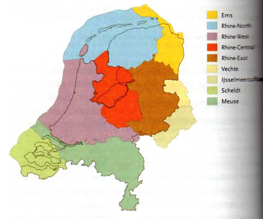
shifted across country borders. The Markermeer-IJmeer is part of Delta Rhine, which contains a
small neighbouring part of the German state North Rhine-Westphalia. Within Delta Rhine the
Markermeer-IJmeer is part of an area called Rhine-Central. Competent authorities – a concept
from the WFD and the Flood Directive – are the provinces of North Holland and Flevoland.
14
Directive 2007/60/EC of the European Parliament and of the Council of 23 October 2007 on the assessment and
management of flood risks, European Journal of Official Publications 2997, L 288/27.
Case Study Markermeer-IJmeer, the Netherlands 25You can also read