QUATERNARY GEOPARK NORTHERN GRANADA VALLEYS - APPLICATION DOSSIER FOR UNESCO GLOBAL GEOPARK - teamsnet
←
→
Page content transcription
If your browser does not render page correctly, please read the page content below
QUATERNARY
GEOPARK
NORTHERN
GRANADA VALLEYS
APPLICATION DOSSIER FOR UNESCO GLOBAL GEOPARK
index
A – IDENTIFICATION OF THE AREA                                D – Economic Activity & Business Plan
A1. Name of the proposed Geopark                         3    D1. Economic activity in the proposed Geopark          34
A2. Location of the proposed Geopark                     4         D1.1. Agriculture and livestock farming           34
A3. Surface area, physical and human geography                     D1.2. Commercial activity and local products      35
    characteristics of the proposed Geopark              5         D1.3. Tourism                                     36
      A31. Area of the proposed Geopark                  5    D2. Existing and planned facilities for the proposed
     A32. Physical Geography                             6       Geopark                                             36
     A33. Biodiversity                                   6         D2.1. Existing facilities and equipment           36
     A34. Access                                         8         D2.2. Planned facilities and equipment            40
                                                              D3. Analysis of geotourism potential of the
     A35.History and Culture                             9        proposed Geopark                                   41
      A36. Description of territory. Population and
                                                                    D3.1. Profile of current tourism of the
            Economic Activity                            10              proposed Geopark                            41
A4. Organization in charge and management
    structure of the proposed Geopark                    12         D3.2. Ecotourism today                           41
                                                                   D3.3. Strengths and opportunities for
      A 4.1 Overview                                     12             ecotourism at the proposed Geopark           42
     A 4.2 Management structure                          12   D4. Overview and policies for the sustainable
     A 4.3 Scientific Working Group                      14      development                                         43
     A 4.4 Budget                                        14        D4.1. Geo-tourism and economy                     43
A5. Application contact person                           15        D4.2. Geo-education                               45
B – GEOLOGICAL HERITAGE                                            D4.3. Geo-heritage                                46
B1. General geological description of the proposed            D5. Policies for, and examples of, community
    Geopark                                              16       empowerment (involvement and consultation)
     B11. Geological Context                             17       in the proposed Geopark                            47
                                                              D6. Policies for, and examples of, public and
     B12. Geological History                             18       stakeholder awareness in the proposed Geopark      48
      B13. Characteristics of, and proposed limits            E – INTEREST AND ARGUMENTS FOR
            for, the proposed Geopark                    20        BECOMING A UNESCO GLOBAL GEOPARK
B2. Listing and description of geological sites within
                                                              E1. Interest and arguments for becoming a UNESCO
    the proposed Geopark                                 21       Global Geopark                                     49
B3. Details on the interest of these sites in terms of
                                                              ANNEX 1. Self-Evaluation Document
    their international, national, regional or local
    value                                                25   ANNEX 2. Copy of section B “Geological
B4. Listing and description of other sites of natural,                   Heritage” of the application
    cultural and intangible heritage interest and             ANNEX 3. Explicit endorsement of relevant
    how they are related to the geological sites                         local and regional authorities
    and how they are integrated into the proposed             ANNEX 4. A Large scale map of the proposed
    Geopark                                              25            Unesco Global Geopark
      B4.1 The Geopark: A Steppe Landscape               25   ANNEX 5. 1-Page geological and geographic
                                                                       summary
     B4.2. The Geopark: A Troglodytic Landscape          28
                                                              ANNEX 6. Listing and description of
     B4.3. Archaeology in The Geopark                    29            geological sites within the proposed
C – GEOCONSERVATION                                                    Geopark
C1. Current or potential pressure on the proposed             ANNEX 7. Master Plan of Quaternary Geopark
    Geopark                                              31            Northern Granada Valleys
C2. Current status in terms of protection of                  ANNEX 8. Marketing Plan of Quaternary
    geological sites within the proposed Geopark         31            Geopark Northern Granada Valleys
C3. Data on the management and maintenance of all             ANNEX 9. Map of protected and conservation
    heritage sites (geological and non-geological)       33            Areas
                                                              ANNEX 10. Bibliography
                                                              ANNEX 11. Press Clipping
                                                              ANNEX 12. Organization in charge and
                                                                           management structure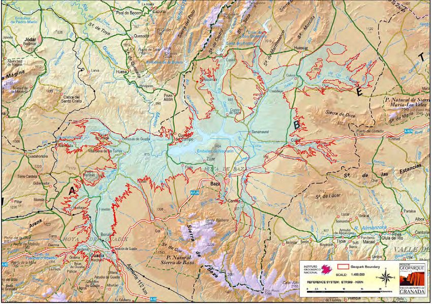
3

A
A1
     Identification
     of area
 Name of the proposed Geopark
       The name of the proposed Geopark is the Quaternary
     Geopark Northern Granada Valleys (QGNGV).

        The Quaternary Geopark Northern Granada Va-
     lleys to become a member of the Global Geopark Ne-
     twork covers an exceptional territory in south-east
     of Spain (Eastern Andalusia). The geology of the                                 Fig. A11 b

                                                                                      region has influenced the culture of its inhabitants
                                                                                      from prehistory to the present. The geology, geo-
                                                                                      morphology, archaeology and culture blend to crea-
                                                                                      te an inseparable whole, in an area that has some of
                                                                                      the most ancestral traditions and human remains of
                                                                                      Continental Europe. (Fig. A11 a,b,c)

                                                                                         The area of this project corresponds with the va-
                                                                                      lleys created by river erosion during the last half million
                                                                                      years. Between approximately 5 million years ago and
                                                                                      0.5 million years ago, this territory was without any
                                                                                      drainage exit to the sea (Endorheic stage), which ge-
                                                                                      nerated an extraordinary record of continental qua-
                                                                                      ternary continental sediments. The following Exorheic
                                                                                      period (after a drainage exit to the sea had developed)
                                                                       Fig. A11 a     has configured its current geomorphology, characteri-
                                                                                      sed by an impressively eroded landscape. The arid na-
                                                                                      ture of the region’s weather, with scarce vegetation on
                                                                                      the valley slopes, favours observation one of the best
                                                                                      quaternaty records of the Continental Europe.

                                                                                         These valleys with their spectacular badlands expo-
                                                                                      se the most wide-ranging and longest-lasting group of
                                                                                      paleontological deposits of Continental European qua-
                                                                                      ternary vertebrates. In particular, large vertebrate de-
                                                                                      posits have been discovered in Early Pleistocene sedi-
                                                                                      ments, with more than 150 sites identified. (Fig.A12-A15)

                                                                                         The Quaternary Geopark also tells us about the
                                                                                      history thanks to the messages left in rocks from the
                                                                                      Mesozoic and Tertiary stages. These rocks have risen
                                                                                      to just below the quaternary sediments which can be
                                                                       Fig. A11 c     found on the valley floors. It also allows observation
     Fig A11a. Panoramic view of the municipality of Gorafe, located in the bank      of more recent geological deformations of the Betic
     of the river Gor. © Gorafe Town Hall
                                                                                      Range, such as active faults. These faults were res-
     Fig A11b. Panoramic view of the cave houses excavated from the Quaternary
     sediment (Gorafe) © EPVFR-IGME
                                                                                      ponsible for ancient earthquakes which generated
     Fig A11c. Archeological site from the Bronze Age (Castellón Alto, Galera). The   singular structures called seismites during the Qua-
     oldest mummified remains in Europe have been found here.©Alberto Tauste          ternary stage. Those structures are among the best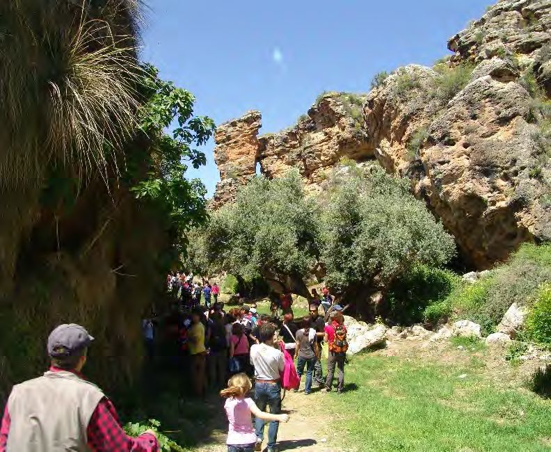
4                                                                                                             QUATERNARY GEOPARK NORTHERN GRANADA VALLEYS

Fig. A12                                                                                    Fig. A13

Fig. A15
             Fig A12. Palaentology station in Fonelas where fossil remains of
                       macrovertebrates can be seen in situ .© EPVFR-IGME
  Fig A13. Singular examples of seismites generated by ancient earthquakes
                  (Baza, Castillejar and Galera) © Francisco García Tortosa
                 Fig A14. Landscape reflecting a non-anthropized territory
Fig A15. Palaentology site in Orce where fossil remains of mamuts have been
                                                  discovered ©Alberto Tauste    Fig. A14

examples known in the world. In addition, associated
                                                                                A2         Location of the proposed Geopark
with these fault zones were formed spectacular struc-                                          The proposed Quaternary Geopark Northern Gra-
tures of fibrous gypsum in tectonic joints. (Fig. A13)                                      nada Valleys is located in the south-east of Spain, spe-
                                                                                            cifically in the north of the province of Granada, wi-
   The Geopark project is a perfect complement to                                           thin the region of Andalusia. (Fig. A21)
the current group of Iberian Geoparks and will contri-
bute in a geological, geomorphological and Palaento-                                           In the western zone the geopark is made up of the
logical Quaternary context to the European network                                          territories contained in the fluvial valleys of the rivers:
for the first time. The park enables conservation and                                       Guadix, Fardes, Gor, Guadahortuna, Guadiana Menor,
exploration of an exceptional Quaternary record, in a                                       Guadalentin and their tributaries (e.g. Arroyo de Hué-
territory with some of the most minimal anthropolo-                                         lago). In the eastern zone the geopark is made up of
gical alteration in Continental Europe. (Fig. A14)                                          the territories contained in the fluvial valleys of the
                                                                                            rivers: Baza, Gállego, Golopón, Cúllar, Castril, Guardal,
   The people of the Province of Granada, throughout                                        Galera, Orce and Huéscar. (Fig. A22)
the 34 municipalities in question, have safeguarded
and protected the area for centuries. Now, the area                                           The geographic coordinates ETRS89 (WGS84) of
will be available for educational purposes and for so-                                      the meridians and parallels that delimit the proposed
ciety as a whole.                                                                           Geopark are: (Fig. A23)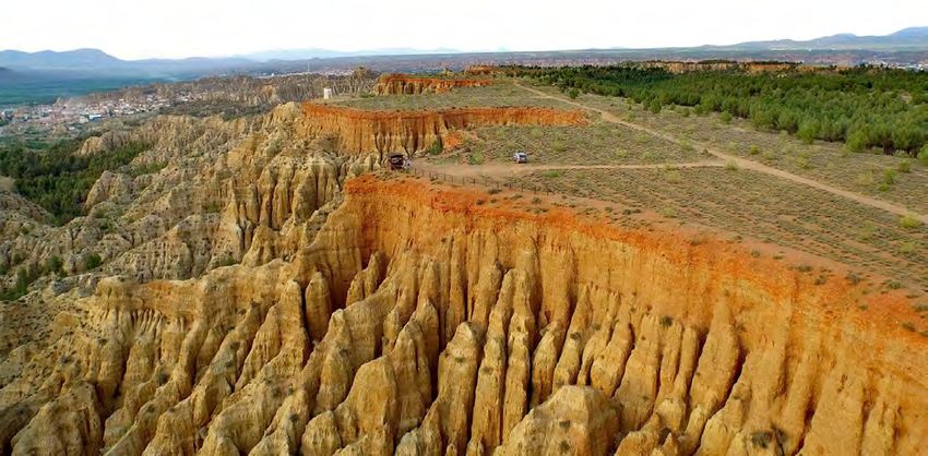
APPLICATION DOSSIER FOR UNESCO GLOBAL GEOPARK                                                                                                                 5

                                                                            Fig A21. Localization of QGNGV

                                                                                                               EAST                           WEST

                                                                                 LONGITUDE                2º16’51,74’’W                  3º20’41,33’’W

                                                                                                              SOUTH                          NORTH

                                                                                  LATITUDE               37º15’42,48’’N                 37º51’44,65’’N
                                                                                  ALTITUDE           534,2 m (Guadiana Menor) 1490,2 m (Jabalcón)
                                                                               Fig A23. Geographic coordinates of QGNGV

Fig. A21

                                                                                               Fig A22. Boundary map of the proposed Geopark into Granada province

  A3         Surface area, physical and human geography
             characteristics of the proposed Geopark
                A 3.1 Area of the Proposed Geopark
                   The Quaternary Geopark Northern Granada Va-
                lleys has a total area of 1,410 km2.

                   This surface area represents 11% of the total of Gra-
                nada, measuring 67 km from north to south and 88 km
                from east to west. 80% of the surface area of the propo-
                sed geopark is occupied by badlands. (Fig. A311)

                                       Fig A311. Characteristic landscape of the proposed
                                                                Geopark.©Alberto Tauste
6                                                                                                         QUATERNARY GEOPARK NORTHERN GRANADA VALLEYS

A 3.2 Physical Geography
   The Quaternary Geopark Northern Granada Va-
lleys extends across the central sector of the Baetic
Cordillera (S.E. Spain). It is located in a depression that
has traditionally been sub-divided into a western sec-
tor (Hoya de Guadix) and an eastern sector (Hoya de
Baza) although in fact it comprises a single intramon-
tane depression which is surrounded by some of the
highest mountains of the Iberian Peninsula (Macizo
Prebético [2381 m], Sierra Mágina [2187 m], Sierra de
Arana-Huétor [1940 m], Sierra Nevada [3484 m], Sie-
rra de Baza-Filabres [2271], Sierra de las Estancias-Cu-
llar [1471 m], Sierra de Orce-María [1612 m]).
                                                                   Fig A321. Riverine vegetation dominate the landscape along the rivers
                                                                   valleys (Guadiana Menor, Hoya de Guadix)
   The connection between these mountain ranges
and the depression is via a gently sloping glacis with                            rra Nevada and from the karstic aquifers of the sierras
altitudes ranging between the 1150 m at the edge of                               of Arana and Baza-Filabres in the Hoya de Guadix (ri-
the depression and 900 m towards the interior where                               vers Verde, Fardes and Guadahortuna, and the streams
the depression is still preserved.                                                Arroyo de Gor and Arroyo de Baúl) and karstic aquifers
                                                                                  of the Macizo Prebético and the sierras of Baza-Fila-
   The landscapes of the area proposed as Geopark,                                bres, María and Estancias in the Hoya de Baza (rivers
formed where the different watercourses that drain                                Baza, Gállego, Golopón, Cúllar, Castril, Guardal, Galera,
the depression meet the glacis, appear at altitudes                               Orce and Huéscar). Parts of these waters run into detri-
between 900 and 550 m. This network of riverbeds                                  tal aquifers of both river basins that subsequently feed
comprises an arid and very rugged landscape with                                  rivers and streams at lower altitudes via springs and
badlands as its outstanding feature, and which inclu-                             also flowing directly into the watercourses. (Fig. A322)
des canyons up to 250 m deep, and the fluvial terra-
ces of the main rivers form alluvial plains, which are                               For thousands of years most human activity has been
known as vegas in this region. (Fig. A321)                                        centred on the vegas, taking advantage of the river wa-
                                                                                  ter to produce irrigated crops. Exploitation of the bad-
   The climate is strongly influenced by the altitude                             lands, on the other hand, has been much more limited
of the hoyas (river basins) themselves (average annual                            and erratic, with small irrigated areas related to springs,
temperature of 13-16ºC) and by the isolation, impo-                               and non-irrigated cereals on gently-sloping land, with
sed by the surrounding mountains, from the maritime                               the rest of the territory restricted to extensive lives-
thermal influence (continental climate with hot sum-                              tock farming and the extraction of natural resources
mers and very cold winters) and the arrival of autumn                             (small game, wood, esparto grass and gypsums).
and spring rains (semi-arid conditions, with 250-350
mm/year rainfall) (De la Cruz Pardo et al., 2010).                                A 3.3 Biodiversity
                                                                                     The current biodiversity of the proposed Geopark
   This latter circumstance leads most of the water-                              is strongly conditioned by both the semi-arid and
courses to be seasonal or sporadic, although the most                             continental nature of its climate and by historical
important rivers and streams may be permanent as a                                processes and geographical factors that have foste-
result of collecting water from the surrounding moun-                             red a very intense relationship with the Maghreb and,
tains. This water essentially comes from thawing in Sie-                          at the regional level, with Mediterranean and riverine
                                                                                  forests, the mountain habitats of the surrounding sie-
                                                                                  rras and the semi-deserts of Almería. (Fig. A331)

                                                                                     This has favoured the development of a very rich
                                                                                  biota (at least 1,500 animal species and 1,129 species
                                                                                  of flora; Cueto et al., 2014; Garrido-García, in prep.) in-
                                                                                  cluding numerous species that are exclusive or almost
                                                                                  exclusive to the Geopark, such as the plant Centau-
                                                                                  rea saxifraga or the snail Helicella zujarensis (exclusi-
                                                                                  ve to Cerro Jabalcón), the plant Limonium alicunense
                                                                                  (which only lives in the vicinity of the spa at Alicún),
                                                                                  the plants Sonchus crassifolius and Limonium majus
                                                                                  and the butterflies Heterogynis andalusica and Eu-
                                                                                  chloe bazae (restricted to the saline habitats of Hoya
Fig A322. Negratín Reservoir with Cerro Jabalcón.©Alberto Tauste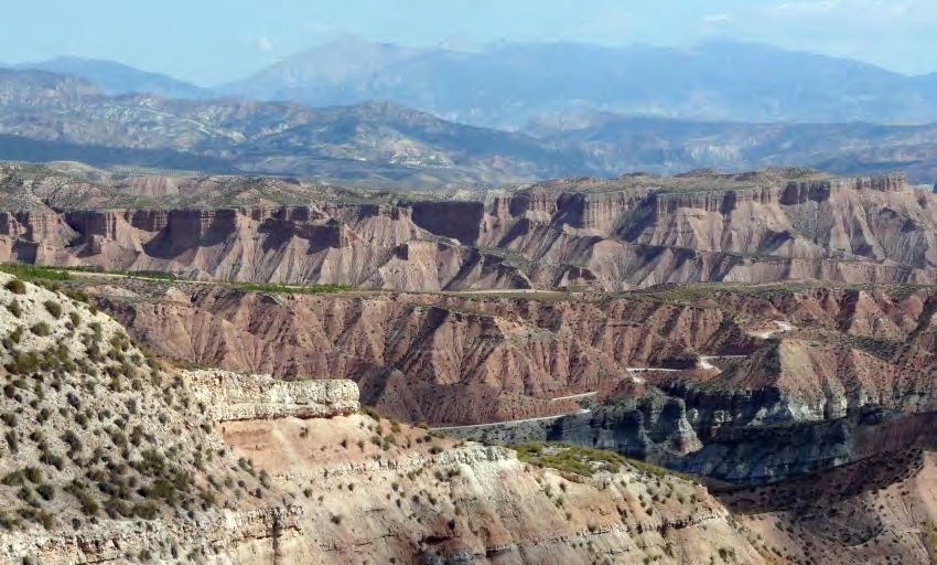
APPLICATION DOSSIER FOR UNESCO GLOBAL GEOPARK                                                                                                            7

                                                                                               tomentosa, Gypsophyla strutium, Ononis tridentata,
                                                                                               Suaeda vera and Arthrocnemum macrostachyum).
                                                                                               Another variant is located over carbonate conglome-
                                                                                               rates and rocky substrata, which favour the develop-
                                                                                               ment of the only natural forests in the Geopark, made
                                                                                               up of Aleppo pine (Pinus halepensis) accompanied by
                                                                                               juniper trees (Juniperus oxycedrus) and kermes oaks
                                                                                               (Quercus coccifera) and, more rarely, savins (Juniperus
                                                                                               thurifera, Juniperus phoenicea) and holm oaks (Quer-
                                                                                               cus rotundifolia). These pine forests have spread artifi-
                                                                                               cially through afforestation, which has altered areas of
                                                                                               semi-desert. Finally, diverse forms of riverine vegeta-
                      Fig A331. General view of the semi-desert vegetation that grows on the   tion appear in the alluvial plains. (Fig. A334)
                gypsum marls of the Hoya de Baza (Barranco del Espartal). ©Jose Ant. Garrido

                de Baza) and the plant Arenaria arcuatociliata (more                              The fauna has been the subject of numerous studies
                widely distributed in the river basins) (Ruiz Ruiz et al.,                     (see, as a summary, Megías et al., 2011; Valera et al.,
                2009; De la Cruz Pardo et al., 2010; Blanca et al., 2011;                      2011). A great variety of insects live in the semi-desert.
                Garrido-García, 2016). (Fig. A332)                                             Of particular environmental importance are the beet-
                                                                                               les of the Tenebrionidae, Meloidae, Scarabaeidae and
                    The biota also includes very endangered species                            Chrysomelidae families, and also ants, grasshoppers
                which, after becoming extinct in the rest of their na-                         and butterflies, with more than 200 recorded noctur-
                tural range, have their last refuges in this territory                         nal species and locations where at least 30 diurnal spe-
                (e.g. the snail Orculella aragonica and the plant Cly-                         cies coexist. Of special interest among the vertebrates
                peola eryocarpa). Furthermore, it also provides a ha-                          are those associated with crags (mountain goats, the
                bitat for numerous Endangered and Critically Endan-                            densest European populations of red-billed choughs
                gered species. In addition to the above-mentioned L.                           and black wheatears, and very important populations
                majus, C. eryocarpa, C. saxifraga and O. aragonica,                            of golden eagles, Bonelli’s eagles, peregrine falcons, ea-
                this territory is home to part of the lastest populations                      gle owls and jackdaws, and a growing presence of gri-
                of the plants Astragalus oxyglottis, Carum foetidum,                           ffon vultures). And beyond the cliffs, the semi-deserts
                Cochlearia glastifolia, Erodium cazorlanum, Haplo-                             are breeding and feeding areas for significant popula-
                phyllum bastetanum, Limonium minus, Plantago ma-                               tions of larks (crested and thekla larks, greater and les-
                rítima, Senecio auricula and Vella pseudocytisus, the                          ser short-toed larks, calandra larks), rollers, black-ea-
                freshwater crayfish Austropotamobius pallipes, the                             red wheatears, corn buntings, European bee-eaters,
                butterfly Plebejus pylaon and the mayfly Torleya naza-                         red-legged partridges and trumpeter finches.
                rita (De la Cruz Pardo et al., 2010). (Fig. A333)
                                                                                                  Moreover, the semi-deserts are a very important
                   The area has very diverse vegetation cover, which                           component of the environmental mechanism that ena-
                includes 30 habitats included in the Habitats Directi-                         bles the survival of birds at the regional level as it serves
                ve 92/43/EEC, and among which can be found some of                             as a winter refuge for species that raise their young in
                the best European examples of Iberian gypsophile plant                         the nearby mountains, such as the black redstart, the
                communities (habitat 1520) and halo-nitrophilous                               leaf warbler and the Eurasian skylark. Overall, these rich
                scrubs (habitat 1430) (De la Cruz Pardo et al., 2010).                         bird communities have led to a significant part of the
                                                                                               Geopark being considered as an Important Bird Area at
                    The landscape is dominated by semi-desert, which                           both national and European level (Infante et al., 2011).
                is the most characteristic habitat of the Geopark and
                is populated by esparto grasses, albardines and diver-                            The fluvial valleys constitute another decisive ele-
                se scrub species (Retama sphaerocarpa, Genista scor-                           ment in the existence of such rich fauna in the Geo-
                pius, Genista pumila, Astragalus clusianus, Rosmarinus                         park, as they allow animals that live nearby to enter
                officinalis, Salsola oppositifolia, Salsola vermiculata,                       the geopark territory. These include animals that live
                Atriplex halimus, Hammada articulata, Suaeda vera,                             in the woodlands of the surrounding sierras (birds
                Helianthemum almeriense, Helianthemum syriacum,                                of the forest, wild boar and genets), those that live
                Ephedra fragilis and Rhamnus lycioides).                                       in aquatic habitats (aquatic birds and invertebrates,
                                                                                               fish, amphibians, otters and Mediterranean water
                   A variant of these habitats appears on the gypsum                           shrews) and humid grasslands (southern water vole
                deposits from the Plio-Pleistocene in the Hoya de Baza                         and Cabrera’s vole). The river valleys also provide
                or from the Triassic in the Hoya de Gaudix, with albar-                        food for species that take refuge in the neighbouring
                dines and gypsophile-halophilous scrubs (Gypsophyla                            badlands (badgers, foxes, beech martins and several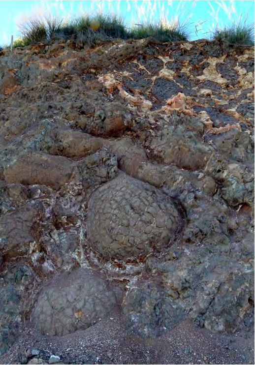
8                                                                                                         QUATERNARY GEOPARK NORTHERN GRANADA VALLEYS

            species of bats). Finally, there are areas where rab-                  The main road connection is the A-92 motorway,
            bits flourish, which enable the presence of specialised             which provides first-class access to the region. The
            predators such as the wild cat, and also the Iberian                rest of the territory is accessible via regional roads,
            lynx. The latter were plentiful in the area until the               which extend to the south in the direction of Puerto de
            1970s and are starting to be spotted occasionally                   la Ragua (GR-5104 and GR-5200) and to the north (A-
            nowadays. (Fig. A335)                                               325, A315, A-326, A317 GR- 5103 and GR-6100/01),
                                                                                towards the province of Jaen, with the A330 towards
               The importance of biodiversity in this territory is              Murcia and the A334 towards Almeria.
            reflected in the existence of a large number of protec-
            ted natural areas (See B4).                                            Furthermore, there is also a railway network run-
                                                                                ning through the region, which connects the main ur-
            A 3.4 Access                                                        ban areas with Almeria, Granada and Málaga. (Fig. 341)
               The proposed area is accessible by different mo-
                                                                                 Road travel time from the main cities. Fig. A341.
            des of transport (plane, train, bus and car). Flights to
            the airports of Granada (65 km), Almeria (100 km)
            and Murcia (120km) mean that the most important
            cities in the south-east of Spain can easily be rea-                         GRANADA                                                   MURCIA
            ched by air. This means that a wide offer of both                            45 min                                                   2h 15 min
            national and international flights is guaranteed. The
            distance to the Malaga- Costa del Sol international
            airport is 185 km. (4th airport in Spain: 16 million
            passengers in 2016).
                                                                                          MALAGA                                                     ALMERIA
                                                                                          2h 15 min                                                  1h 10 min

Fig. A332                                                          Fig. A335

                                               Fig. A334

                                               Fig A332. The Heterogynis andalusica butterfly lives only in the semi-desert of Hoya de Baza. © Jose Ant. Garrido
                                               Fig A333. After being extinct in other areas Clypeola eryocarpa only survives in the semi-desert of the
                                               Geopark.
                                               Fig A334. On the limestone conglomerates and rocky substrate grow the only natural forests of the Geopark,
                                               dominated by the pines (Canyon of Arroyo de Baúl)© Jose Antonio Garrido.
                                               Fig A335. Rivers and associated irrigation systems allow the presence in the Geopark of aquatic fauna, such
Fig. A333                                      as gallinetas (Gallinula chloropus).© Jose Antonio Garrido
APPLICATION DOSSIER FOR UNESCO GLOBAL GEOPARK                                                                                            9

   A 3.5 History and Culture                                      The transition from Antiquity to the Middle Ages was
      The unique physical conditions of this territory         recorded by the testimonies of early Christianity, which
   have influenced its history, along with successive wa-      was represented by the bishop of Guadix at the Synod
   ves of occupation and organisation from prehistoric         of Elvira in the 4th century.
   times up to the present day. These special physical
   and geological conditions provide the proposed Geo-             From 711 onwards, the Muslim presence left an in-
   park with an extraordinary heritage value, where the        delible mark in places that have maintained toponyms,
   archaeological and palaeontological sites are crucial       physical features and traditions, with the style of urban
   to understanding the human settlement processes in          architecture being especially characteristic (Fig. A353).
   the European continent.                                     The Alcazabas (citadels) of Guadix and Baza were erec-
                                                               ted in the central point of a territory in which castles
      The strong personality of the groups that inhabi-        such as those at Bácor, Castril, Freila, Zújar, Aldeire and
   ted these lands, manifest in the clear awareness of         Lanteira, and the series of watchtowers that marked
   the existence of life after death, was projected by         out the territory where it was most rugged, are current-
   the megalithic groups at Gor and Gorafe. In the same        ly the best reflection of medieval organisation.
   way, the sites at Cerro de la Virgen (Orce), El Malagón
   (Cúllar) and Castellón Alto (Galera) provide evidence          At the end of the medieval period, and determined
   of communities that were located in characteristic se-      to put an end to the presence of al-Andalus once and
   ttlements at altitude, ordered with an incipient sen-       for all, the Catholic Kings intensified the incorporation
   se of urban planning. Antiquity was characterised by        of the regions of Huéscar, Baza and Guadix into their
   the presence of the Argaric culture in the south-east       kingdom during the third phase of the Granada War,
   of the Iberian peninsula. Meanwhile, the start of the       from 1487 to 1489, this last year corresponding to
   orientalisation of these lands was embodied in the          the toughest campaign of the conflict. The Castilian
   Iberian necropolis at Tútugi, where a monument was          Crown then introduced the main institutions of politi-
   erected to the cult of death, and at Cerro del Santua-      cal, military and religious control, through the exten-
   rio, in Baza, where the discovery of female images of       sive jurisdiction of a Crown official known as corregi-
   the funerary cult reaffirm this close relationship with     dor, and the restoration of the former episcopal see.
   the territory, from a clearly symbolic perspective with
   a strong magical and religious component.                      These institutions were responsible for implemen-
                                                               ting a policy of religious and cultural assimilation of the
      During Roman times, the historian Titus Livius, and      majority Morisco population, to the point where they
   also Strabo and Pliny, provided information on the          provoked the rebellion of 1568 which had tragic con-
   Bastetania, whose eponymous city would be Basti             sequences for these regions. The Church promoted
   (Baza), located at Cerro Cepero.                            a development of the arts at its service, which made
                                                               this region one of the wealthiest dioceses in terms of
      This region was divided into different areas, in a way   movable heritage. Gaudix cathedral and the collegiate
   that was directly dependent on each of the oppida -Tútu-    church at Baza, along with outstanding examples of
   gi (Galera), Arkilakis (Puebla de Don Fadrique), El Fo-     late Gothic, Renaissance and Mudéjar religious archi-
   rruchu (Villanueva de las Torres), Basti (Baza) and Acci    tecture in the province, are the most obvious exam-
   (Guadix)-. These functioned as micro-states in which all    ples of the Church's rich patrimony. (Fig. A351) (Fig.A352)
   activities related to the exploitation and management of
   resources depended directly on the aristocracy.                There was a need to christianise that had an urban
                                                               and architectural dimension, as well as favouring the
      The period of territorial expansion, based on mecha-     appearance of cults and ritualisation in the new settings.
   nisms of agricultural colonisation, was during the 4th      Some of these celebrations had their origins in the north
   century BC, with fortifications at Las Angosturas de        of the peninsula, such as the case of the Saints Alodía
   Gor, Cerro de los Almendros and Fuente Amarga in Hués-
   car and Los Castellones in Laborcilla.

      Some centres disappeared as a consequence of the
   Second Punic War, while others survived and allied
   themselves with Roman power. Later, the substitution
   of the Via Heraclea by the Via Augusta isolated the re-
   gion of Huéscar from the commercial developments
   that led many areas to prosper, especially the Giulia
   Gemella Acci colony (Now Guadix), where toponyms
   such as Purullena, Exfiliana, Graena, Freila and Galera     Fig A353. The Arab baths of Baza date back to the 13th century (Almohad
   make the scale of the settlement quite clear.               period). @Provincial Council of Tourism
10                                                                                                  QUATERNARY GEOPARK NORTHERN GRANADA VALLEYS

     and Nunilón in Puebla de Don Fadrique and Huéscar,                          Baza, Guadix, Huescar and Montes. All the emplo-
     and the case of the Virgen de la Piedad, linking the ci-                    yers' associations of the region are also participating
     ties of Baza and Guadix since the late 15th century in a                    in the project. Both the Regional Government (Junta
     festival called the Fiesta de Cascamorras, which was de-                    de Andalucia) and the Provincial Government (Dipu-
     clared to be of International Tourist Interest in August                    tación Provincial de Granada) are part of the Quater-
     2013. Moreover, there are also festivities such as those                    nary Geopark Northern Granada Valleys.
     of Moors and Christians, with unique features wherever
     they are held (Zújar, Benamaurel, Cúllar and Aldeire),                      Population and Demographic Evolution.
     along with Holy Week celebrations in every one of the                          The population of the municipalities that make up
     towns and villages in the north-east of Granada.                            the proposed Geopark stands at 92,973 inhabitants.
                                                                                 The main cities of Guadix and Baza concentrate more
        The 18th and 19th centuries saw some attempts                            than 40% of the inhabitants of the territory. The rest of
     at modernisation, and the amount of land being used                         the population is distributed in municipalities, which,
     was increased. Today there are industrial complexes                         in many cases, do not exceed 2,000 inhabitants.
     that are silent witnesses, although there are some at-
     tempts to revive them. New factories, railway infras-                         It is therefore a fundamentally rural area – 93 % of
     tructures and agricultural holdings that are added to                       the population live in areas with less than 50 inhabi-
     existing ones make up an important industrial heritage,                     tants per square kilometre - with population centres
     to which must be added the mining tradition as one of                       huddled in the spectacular steppe-like and arid lands-
     the most extraordinary values and best-defined signs                        cape of the north of Granada. (Fig. 361 )
     of collective identity.
                                                                                    The population structure is characterised by age-
        These special cultural features have developed diffe-                    ing above the provincial and regional average and
     rent kinds of modern habitat, such as the Moorish moun-                     a continuously declining birth rate. It is important
     tain house, the Castilian house, the farmhouse and the                      to note the feminisation of the territory, especially
     cave, in extraordinary typological density and exempla-                     among the older age groups.(Fig.362)
     riness. Furthermore, the rich catalogue of constructions
     linked to the traditional agricultural economy should not                      The evolution of the population shows a depopula-
     be overlooked, and others related to the culture of wa-                     tion trend with an ongoing process of population loss in
     ter. These are testimonies that have endured and reflect                    the territory. The emigration of young inhabitants and
     different historical periods and the social, cultural and                   women who seek educational and employment oppor-
     economic conditions that typify them.                                       tunities in other areas is the main factor.In recent years,
                                                                                 however, these trends have started to be curbed with
     A 3.6 Description of territory.                                             the arrival of foreigners who choose to reside in the area.
     Population and Economic Activity.
        The proposed Geopark involves the participation                             According to demographic data, the territory's po-
     of 34 town and village councils, which belong to 4 ad-                      pulation declined by 10.04 % in the period 1999-2016,
     ministrative districts within the province of Granada:                      in contrast with the results in the province and the re-
                                                                                 gion, where there was an increase in the population
                                                                                 over the same period. More specifically, the most sig-
                                                                                 nificant loss of inhabitants (8.2%) has occurred in the
                                                                                 last decade (2005-2016).

                                                                                 Economic Activity
                                                                                    The proposed territory largely depends on rain-fed
                                                                                 agriculture (15% of the local population work in agri-
                                                                                 culture), based on the cultivation of cereal, legumes,
                                                                                 vines, olives and almonds. This activity accounts for
                   Fig A351. Guadix Cathedral ©Provincial Council of Tourism     most of the surface area and working population of
                                                                                 the proposed Geopark. (see d1)

                                                                                    Livestock farming is focused on raising Segura
                                                                                 breed of sheep, perfectly adapted to the tough con-
                                                                                 ditions of the area.

                                                                                    (Fig. 363) Some very high quality products made in the
                                                                                 territory are guaranteed by protected designation of ori-
     Fig A352. Convent of Santo Domingo.One of the finest examples of Mudejar
                                                                                 gin (PDO) and protected geographical indication (PGI).
                    coffered ceilings in Guadix.@Provincial Council of Tourism
APPLICATION DOSSIER FOR UNESCO GLOBAL GEOPARK 11
Ceramics in Guadix and Purullena is one of the
outstanding craft activities in the area. Equally im-
portant, however, is artisanal work with wood, espar-
to grass and the preparation of cured meats. Histo-
rically, mining has been very important in the area.
have great potential and are trying to take advanta- 0-10 hab/km2
ge of the exceptional nature of the territory and the 10-20 hab/km2
wide range of possibilities for cultural and sustainable 20-30 hab/km2
tourism. The Tourism Observatory of Granada recor- 30-40 hab/km2
ded a total of 1,131,296 visitors for the period 2011 40-60 hab/km2
to 2017, showing an increase of 74.52%, with people >60 hab/km2
mainly attracted by the archaeological and palaeon-
tological resources, nature and the landscape, and
also the cultural legacy of the different civilisations
that have populated the territory of the proposed
Geopark. (Fig. A365)
Número de visitantes/año
250.000
200.000
150.000
100.000
Fig A361. Map of population
50.000 density of municipalities
affected by the delimitation
0 of the proposed Geopark.
2011 2012 2013 2014 2015 2016 (2016)@INE,SIMA / IAEC.
DIPGRA
Fig A365. Evolution of the number of tourist @Provincial
Council of Tourism.
PROPOSED GRANADA ANDALUSIA SPAIN
GEOPARK PROVINCE REGION
POPULATION DENSITY (HAB/KM2) 32 72 96 92
DEMOGRAPHIC DEVELOPMENT (1999-2016) -10.40 +12,6 +15,8 +15,8
POPULATION AGES 0-16 (%OF TOTAL) 14,9 17,5 18,3 16,1
POPULATION AGES 65 AND ABOVE (%OF TOTAL) 21,8 17,2 16,3 19,7
Fig A362. Demographic Data 2016 ©INE,SIMA / IAEC. DIPGRA
Fig A363. Products made in the territory guaranteed by protected
designation of origin (PDO) and protected geographical
indication (PGI).12 QUATERNARY GEOPARK NORTHERN GRANADA VALLEYS
A4 Organization in charge and management
structure of the proposed Geopark
A 4.1 Overview
The proposed Quaternary Geopark Northern Gra- rities), Consortiums, Groups of Local Development,
nada Valleys is a local development initiative at su- Citizenship and Civil Society, Economic Sectors and
pra-municipal level, based on the exceptional value Collaborating Scientific Institutions (Geological and
of the geological heritage and the cultural and natural Mining Institute of Spain, University of Granada, Uni-
resources of the area, and undertaken using a me- versity of Jaén). The organisation and coordination of
thodology of cooperation and participation of all the the territorial agents has been carried out through the
agents of the local population. The territory has been creation of Working Groups representative of all sec-
working on the project even before 2002, and during tors that affect the future geopark. (Fig. A412)
this time, it has received increasing institutional, eco-
nomic and social support. (Fig. 411) A 4.2 Management structure
Responsibility for the management and coordi-
The proposed Geopark is the result of a formal, pu- nation of the proposed Geopark lies with the Qua-
blic process organised to promote the participation ternary Geopark Northern Granada Valleys Project
and collaboration of all the territorial agents involved: Coordinating Committee, made up of representati-
Provincial Council of Granada, Regional Government ves of the institutional, socio-economic and scientific
of Andalusia, Town and Village Councils and Local En- agents involved in the project, through an agreement
tities, Mancomunidades (Associations of Local Autho- signed on 07 November 2017.
PROMOTER GROUP
Provincial Council of Granada
Rural Development Association of Guadix
Association of Rural Development Groups of the
Altiplano
Apromontes
Consortium for the Development of los Montes
Orientales
SOCIO - ECONOMIC WORKING GROUP
Employers’ Association of the Altiplano
Intersectoral Employers’ Association
of Guadix,
Employers’ Association of the District
of Huéscar
Altiplano Tourism Association
Hotel and Tourism Association of the
District of Guadix
SCIENTIFIC WORKING GROUP Andalusian Cave Association
INSTITUTIONAL WORKING GROUP Association for Sustainable tourism of
EPVRF-IGME the Altiplanicies Granadinas,
University of Granada Association of Local Authorities of the Winegrowers “Altiplano Sierra Nevada”
University of Jaen District of Baza Association
University of Alicante Association of Local Authorities of the “Artesanos Guadix” Association
University of Sevilla District of Guadix Baza Trade Association
Univesity of Murcia Association of Local Authorities of the “Andalucía Emprende” Andalusian
CEP Guadix District of Huéscar Public Foundation
MNCN-CSIC Regional Goverment-Junta de Andalucía
AEQUEA University of Granada.
Fig A412. Structure and members of the Working GroupsAPPLICATION DOSSIER FOR UNESCO GLOBAL GEOPARK 13
ACTIVITY FUNDING PROGRAMME/SPONSOR
2002 Environmental knowledge programme for schools: “Know Your Region and Discover Your Past” (2003-2006) 25.000,00 € LEADER PLUS/Others
2004 Tourist Usage of the Cultural Georesources of the District of Guadix Plan 43.384,00 € LEADER PLUS
2006 Seminars on touristic use of geodiversity €18,000.00 LEADER PLUS
2006 Exhibition: “Human Beings and the Environment: Prehistoric Fauna” District of Huéscar Tourism Plan
2007 Report: “Scientific and Technical Proposal of the European Geopark Declaration” 29.928,00 € PRODER-A
Paleontological heritage exhibition of the District of Guadix 7.000,00 €
Joint cooperation action “Geodiversity: A Solution for Sustainable Rural Development (2007-2013)
Participation in Workshop on Geopark Interpretation Methods in County Kerry (Ireland)
20.000,00 € LEADER PLUS
Study visit to the Haute Provence Geopark (France)
Attendance at the First Seminar on the Subbetic Geopark (European Geopark Week) in Cabra (Córdoba, Spain)
2008 Attendance at the 3rd International UNESCO Conference on Geoparks in Osnabrück (Germany)
Tourist Usage of the Cultural Georesources of the High Plain of Granada Plan 44.892,00 €
LEADER PLUS
Joint cooperation action “Geodiversity: A Solution for Sustainable Rural Development (2007-2013) 200.000,00 €
Geotourism itinerary “Geology in the District of Guadix 2011. The most dynamic landscape in Europe”.
2009 Organisartion of Annual SEQS Conference 2009 “The Quaternary in the South of Spain: A Bridge Between Africa
and the Alpine Domain” Department for Culture of the
200.000,00 €
Joint cooperation action “Geodiversity: A Solution for Sustainable Rural Development (2007-2013) Regional Government of Andalusia
Study visit to the Sobrarbe Geopark (Spain)
2011 Geotourism itinerary “Geology in the District of Guadix 2011. The most dynamic landscape in Europe”. FEDER
Candidacy Report of the European Quaternary Geopark EPFVRF/IGME
2012 Geoemployment Project: Geodiversity as a Source of Employment (2011-2013)
Ministry for Agriculture, Food and
Study visit Management and Organisation of the Cabo de Gata-Níjar Geopark (Spain) 100.000,00 €
the Environment
Study visit to Management and Organisation of the Basque Coast Geopark (Spain)
2013 Geoemployment Project: Geodiversity as a Source of Employment (2011-2013)
Ministry for Agriculture, Food and
Participation in the 10th Meeting of the Commission on Geological Heritage of the Geological Society of Spain 50.000,00 €
the Environment
Participation in the First International Geotourism Conference in Cabra (Córdoba, Spain)
2015 Technical analysis of the viability of the UNESCO Global Geopark Project Candidacy
Identification of the Sites of Geological Interest.
Identification and mapping of existing structures and resources.
135.000,00 € Provincial Council of Granada
Design of the QGNGV Communication Plan and Social Networks Project
Sponsorship Dossier of the QGNGV project
Design of the Participation Plan of the QGNGV project
2016 Creation of working groups for candidacy: Promotional, Scientific, Institutional, Socio-economic and
Communication groups.
Preparatory work meetings: Spanish National Geoparks Committee, Molina de Aragón-Alto Tajo Geopark.
Candidacy presentation seminar with the town councils involved in the project and the Regional Government
of Andalusia (Delegation of the Government and Department for the Environment and Organisation of the 135.000,00 € Provincial Council of Granada
territory).
Meetings with the Employers’ Associations of the 4 districts.
Meetings with the presidents of the Local Authorities and Regional Delegation from the Department for the
Environment and Organisation of the territory.
2017 Study visit to the Villuercas Ibores Jara Geopark with a delegation of 14 territorial representatives of the 4 districts.
Seminars: “Geoparks and Geodiversity and Sustainable Development of the Quaternary Geopark Northern
Granada Valleys Project”. (1 seminar on Exchange of Experiences with Spanish Geoparks, 1 seminar on guided
tours to the QGNGVproject)
Round table with the directors of other Geoparks in Spain. (Villuercas, Costa Vasca and Molina Alto Tajo)
Presentation and dissemination of the project to the Turkish Development Agency.
Publication of the Official Gazette of the Province of Granada dated 27 March 2017 for the public knowledge of
the North Granada Valleys Quaternary Geopark” project.
Presentation of the Geopark project to the Spanish Commission for Cooperation with UNESCO requesting its
support.
Meeting with the Guadalinfo Centres of the territory for the dissemination activities planning
Meeting with the heads of the teaching schools of the territory for Education Programme
First week of QGNGV project activities: 650 attendees.
Description of the week’s activities: Flamenco and Territory. (400 attendees) .Guided tours to resources and
exhibition centres (100 attendees). Astronomical Observation: (100 people). Scientific Committee Meeting (22
scientists). Guided tours to geological resources for key stakeholders in the territory: (25 people)
Social network campaign to support the candidacy on Instagram, Facebook and Twitter. 135.000,00 € Provincial Council of Granada
Signature of collaboration protocol for the creation of the North Granada Valleys Quaternary Geopark.
Collaboration protocol for the creation of the North Granada Valleys Quaternary Geopark.
Geologist of the Geopark collaboration agreement (Between the Granada High Plains Association and the
University of Jaén)
Design of the QGNGV Strategy and Master Plan
Business support campaign for the Geopark project
Geopark audiovisual campaign
Presentation of QGNGV candidacy at the Annual Meeting of the European Network of Geoparks (the Azores,
Portugal)
Design of the Marketing plan of the project.
Training in the methodology for the creation of tourism products for enterprises in the territory.
Presentation of candidacy at the National Ecotourism Conference (Guadalupe, Cáceres) November 2017
Training Course of Education Programme "Didactic possibilities of QGNGV"
International Seminar: " Sustainable Tourism and Geoparks" ( Sevilla) November 2017.
Simbolic Act in order to supporting the QGNGV candidature
Fig A411. Overvieew and main actions carried out in the proposed Geopark.14 QUATERNARY GEOPARK NORTHERN GRANADA VALLEYS
The Coordinating Committee is a participatory A 4.3 Scientific Working Group
management structure comprising 1 representative The proposed Geopark has a consolidated scien-
of each signatory, except in the case of the Associa- tific working group, comprising researchers of re-
tions of Local Authorities of Baza, Guadix and Hués- nowned prestige and with substantial experience in
car which will be represented by 2 people for each on projects and scientific research in the area. This wor-
the aforementioned associations. The Coordinating king group's task is to advise, coordinate and promo-
Committee has the assistance of the Technical Com- te measures related to the research, analysis, study,
mittee and the Scientific, Socio-economic and Institu- dissemination and scientific knowledge linked to the
tional Working Groups. (Fig. A421) project. It has been operating since 2015 and has par-
ticipated actively in the proposal to define the scope
The President of the Provincial Council of Granada of this project and the scientific studies that confirm
occupies the presidency of the Coordinating Commi- the exceptional nature of the territory. ( Fig. A431)
ttee. Furthermore, the Provincial Council of Granada
will provide the technical secretariat of this commit- A 4.4 Budget
tee. Rural Development Groups, as territorial manage- The planned financing and investment conform to
ment authorities of development programmes in the the following lines of funding. (See annex 7):
area, are responsible for running the Geopark project. • Action Plans for Local Development Strategies for
LEADER rural areas Guadix, Altiplano and Montes,
In this regard, the Quaternary Geopark Northern envisaged for the 2016-2022 period.
Granada Valleys Project Strategy has been designed • UNESCO Geopark plan of the Provincial Council of
(See annex 7), which includes the steps that the sig- Granada.
natories are going to take in accordance with their • Actions and investment underway and/or program-
own lines of action and financial frameworks, via med by different departments of the Provincial
the complementarity and synergies between plan- Council of Granada (Tourism, Culture, Sports, Local
ned actions. Development and Public Works and Highways) in
the area of the Geopark.
COORDINATING COMMITTEE Provincial Council of Granada
Quaternary Geopark Northern Rural Development Association of Guadix
Granada Valleys Project Association of Rural Development Groups of the Altiplano
Apromontes
Consortium for the Development of los Montes Orientales
Geological and Mining Institute of Spain (IGME)
University of Granada
University of Jaen
Association of Local Authorities of the District of Baza
Association of Local Authorities of the District of Guadix
Association of Local Authorities of the District of Huéscar
Employers’ Association of the Altiplano
Intersectoral Employers’ Association of Guadix,
Employers’ Association of the District of Huéscar
PRESIDENCY Altiplano Tourism Association
Hotel and Tourism Association of the District of Guadix
Provincial Council of Granada
Andalusian Cave Association
Association for Sustainable Tourism of the Altiplanicies Granadinas
MANAGEMENT QUATERNARY GEOPARK NORTHERN GRANADA
Rural Development Association VALLEYS PROJECT STRATEGY
SECRETARY´S OFFICE
Provincial Council of Granada Education Sustainable Tourism Scientific
Programme Development Programmes Programme
Fig A421. Structure and members of the Quaternary Geopark Northern Granada Valleys Project Coordinating Committee.APPLICATION DOSSIER FOR UNESCO GLOBAL GEOPARK 15
HUMAN RESOURCES
WORK STRUCTURE
AREA NAME PROFESSIONAL FIELD ENTITY
TIME QGNGV
Antonio Manager of Association of Rural Development
PART TIME
Román Groups of the Altiplano
Juan Jose Manager of Rural Development Association of
PART TIME
Manrique Guadix
Raquel Local and Tourist Project Officer of Rural Development
PART TIME MANAGEMENT
MANAGEMENT Jiménez Development Association of Guadix
Project Officer of Association of Rural
AND LOCAL Enrique Muriel
Development Groups of the Altiplano
DEVELOPMENT
Torcuato Manager of Consortium for the Development
PART TIME
Cabrerizo of Los Montes Orientales
Myriam Prieto Head of Development Service DIPGRA PART TIME
Local Development
Diego Garcia Project Officer DIPGRA FULL TIME
Financial SECRETARY OFFICE
Nieves Molina Project Officer DIPGRA FULL TIME
Management
Fco. Juan Geological Sciences
Departament of Geology. University of Jaen PART TIME GEOLOGIST
García-Tortosa University of Jaen
SCIENTIFIC
Geological and SCIENTIFIC
EARTH SCIENCES Alfonso Coordinator of "Valle del Río Fardes"
Mining Institute of PART TIME WORKING GROUP
Arribas Paleontological Station.
Spain, (IGME) COORDINATOR
Fig A431. Members of the Scientific Working Group
SCIENTIFIC WORKING GROUP
AREA OF KNOWLEGMRE INSTITUTION
Coordinator
Mr. Alfonso Arribas Herrera Quaternary Palaeontology EPVRF-IGME
Geologist of proposed Geopark
Mr. Francisco Juan García Tortosa Geodynamic University of Jaén
Members
Mr. Pedro Alfaro García Tectonic University of Alicante
Mr. Juan Arroyo Marín Botany University of Sevilla
Mr. José Sebastián Carrión García Botany and Quaternary Palaeoecology University of Murcia
Mrs. Concepción Fernández Leyva Mineralogy IGME
Mr. José Antonio Garrido García Zoology EPVRF IGME
Mr. Román Hernández Manchado Geoscientific Information Systems IGME
Mr. Antonio López Marcos Archeology Guadix
Mr. Carlos Lorenzo Carnicero Geographic information systems IGME
Mrs. Elvira Martín Suárez Stratigraphy and Palaeontology University of Granada
Mr. Domingo Molina Hernández Teaching CEP Guadix
Mr. Jorge Morales Romero Palaeontology of mammals MNCN-CSIC
Mr. José Antonio Peña Ruano Geophysical prospecting University of Granada
Mr. Francisco J. Rodríguez Tovar Stratigraphy and Paleontology University of Granada
Mrs. Ana Rodrigo y Sanz Teaching IGME
Mr. Juan Carlos Rubio Campos Geology IGME
Mr. Carlos Sanz de Galdeano Equiza Dynamics of the Lithosphere UGR CSIC
Mr. Pablo G. Silva Barroso Palaeosismology AEQUA
Mr. Jesús Miguel Soria Mingorance Stratigraphy and Marine sedimentology University of Alicante
Mrs. Juana Vegas Salamanca Geological Heritage IGME
Mr. César Viseras Alarcón Stratigraphy and continental sedimentology University of Granada
A5 Application contact person
Presidency Antonio Román
Jose Entrena Avila Manager Altiplano de Granada Rural Development Group
President of the Provincial Council of Granada Mayor, 2 18830 Huéscar – Granada
C/Periodista Barrios Talavera 1. 18014 Granada (España) Teléf.: 0034 958742314
www.dipgra.es antonio@altiplanogranada.org
www.altiplanogranada.org
Management
Juan José Manrique López Secretary's Office
Manager Guadix Rural Development Group Myriam Prieto Labra
Ctra. Murcia, s/n "Antigua Azucarera" Head of Development Service
18500 - GUADIX (Granada) Diputación de Granada
Tel: 0034 958 66 50 70 - 0034 958 66 10 48 Av. Andalucia s.n. 18015 Granada (España)
juanjo@comarcadeguadix.com mprieto@dipgra.es
www.comarcadeguadix.com 0034 95824786716 QUATERNARY GEOPARK NORTHERN GRANADA VALLEYS
B
B1
Geological
Heritage
General geological description of the proposed Geopark
The Quaternary is the geological time period in the tioned endorheic stage, for approximately 5 million
history of the Earth that covers the last two and a half years. Its mouth was basically located to the north
million years of evolution of the planet and the life on of the Jabalcon mountain and was conditioned over
it (from 2.58 million years ago to the present). time by the evolution of the Baza fault (located to the
east of Jabalcon mountain. This active Baza fault is
The Quaternary Geopark Northern Granada Va- responsible for the subsidence of the eastern sector.
lleys (QGNGV) is a geological and natural area that The rocks deposited by this river and lake contain nu-
contains evidence of the geological history of a river merous vertebrate fossil sites that inform us about
and a lake, which were active between 5.3 million the biological and environmental evolution during
years and, approximately, 500,000 years ago during the Pliocene and the Pleistocene.; their records of
an endorheic stage. Later, its sediments gradually the Early Pleistocene (basal Quaternary) are unique
eroded during a new exorheic stage that continues in the European context.
today, which has shaped the current structure of the
Geopark, characterised by tens of thousands of bad- Approximately 500,000 years ago, when the lands-
lands. The most recent geological history of this area cape of the whole basin was dominated by a large glacis
to the north of the province of Granada is recorded in created by the filling of the depressed areas and the ero-
the Pliocene and Pleistocene rocks (from 5.3 million sion of the internal reliefs of the basin, the region beca-
years ago to the Present), which cover a Mesozoic ba- me exorheic. The basin was captured by a tributary of
sement constituted by Triassic, Jurassic, Cretaceous the Guadalquivir River, the Guadiana Menor River. Sin-
rocks and Neogene marine sedimentary rocks. ce then, the Fardes and Guadiana Menor rivers and their
many tributaries have been actively eroding the rocks,
The protagonists of its continental geological history mainly detrital (in the western sector) or chemical (in
are, essentially, a river (the paleo Fardes) and a lake (the the eastern sector), creating a vast and marvellously
Baza paleolake), whose legacy is recorded in the exposed preserved landscape of badlands mainly of Plio-Pleisto-
rocks in the present-day river valleys of North Granada. cene rocks, with a scarce anthropic influence.
From 5.3 million years ago, the paleoriver (western Comprises an area in which that river and lake evol-
sector) and the paleolake (Eastern sector) gradually filled ved geologically (an area in which its geological and
this large intramontane depression to the north of Gra- paleobiological evolution can be read) and delimited
nada, predominantly with fluvial sediments in the wes- by the geographical extension of its physical develo-
tern sector – “Hoya de Guadix” - (associated temporally pment over time, only accessible via the most recent
and spatially with alluvial fan, palustrine and lacustrine Quaternary fluvial system.
deposits), and with lacustrine sediments in the eastern
sector – “Hoya de Baza” - (also associated temporally It is the geological history of a river (western sec-
and spatially with alluvial fan and palustrine deposits). tor) and a lake (eastern sector). A river and a lake that
during part of their sedimentary stage left stone evi-
This dynamic generated an exposed and accessi- dence of the ecosystems of the old Quaternary. During
ble succession of quaternary sediments (mainly Early the fluvial erosion stage of the modern Quaternary,
Pleistocene) with an average thickness of 100 m in the rivers have exposed rocks that reveal the geologi-
the western sector, and even thicker in the eastern cal history of the last 250 million years. There is a sig-
sector due to a higher subsidence (with a potential nificant impact on the landscape by sedimentary rocks
thickness of Quaternary rocks of several hundred of the last 5 million years (old river plains and lacus-
metres). The source of this old paleoriver, the Fardes, trine shores inhabited by a spectacular array of large
was the same as today, in the surrounding Sierra de mammals), exposed by the current river valleys. In ad-
Huétor, flowing into the lake in the eastern sector, dition, we can also observe marine rocks from former
which constituted its base level during the aforemen- deltas and reefs of 8 million years ago (when the Atlan-APPLICATION DOSSIER FOR UNESCO GLOBAL GEOPARK 17
tic Ocean communicated with the Mediterranean Sea The Internal Betic Zone, unlike the External Zone, is
via a marine corridor known as the North Betic Strait), constituted by Palaozoic rocks and a Mesozoic and Ter-
marine rocks from the Palaeogene, and abyssal marine tiary sedimentary cover. The Internal Zone is divided into
deposits from the Cretaceous and on shallow shelves several tectonically overlapping complexes, which from
from the Jurassic (from the Tethys Sea), in the long top to bottom are the Malaguide-Dorsal, without alpine
Mesozoic era during which, in this part of the planet, metamorphism, the Alpujarride and the Nevado-Filabri-
rifting of tectonic plates was occurring, the most di- de, both with alpine metamorphism. Most of the sedi-
rect evidence of this being huge extensions of basaltic ments that gave rise to the rocks of the Malaguide, Dor-
pillow lavas, which today make up mountains. sal and Alpujarride were deposited far from their current
position, towards the east and south-east, in some cases
B1.1.Geological Context several hundred kilometres away, and were tectonically
The proposed Geopark is located in the central sec- displaced to their present position. (Fig. B112).
tor of the Betic Cordillera, which occupies the south
and south-east of the Iberian peninsula, covering an The Malaguide complex is formed by a Paleozoic
area approximately 600 km long and 200 km wide. basement and a Mesozoic and Tertiary cover with
The Betic Cordillera may be divided into several large predominantly red Triassic detrital sediments, over
geological domains, including the External Betic Zone which appear dolostones and limestones, from the
and the Internal Betic Zone (this latter also known, in- Triassic and the Jurassic, with more marly Cretaceous
cluding other sub-domains, as the Alborán Domain). and Tertiary. Malaguide outcrops do not exist within
Several Neogene basins formed over these domains, the Geopark, but they are very close to the western
including the Guadix-Baza basin which takes in the part in the Diezma sector. The Dorsal is a set of units
majority of the QGNGV territory. All these Neogene that appear between the Malaguide and part of the
basins together could be considered as another large External Zone of the Betic Cordillera and, above all,
domain within the cordillera. (Fig. B111) part of the Rif in North Africa. It is made up of Meso-
zoic and Tertiary series in which carbonate materials
The External Betic Zone occupies the southern and dominate. From a paleogeographic point of view, a
south-eastern margin of the Iberian Massif where, du- large part of the rocks assigned to the Dorsal could be
ring the Mesozoic and part of the Cenozoic, there was considered as a sedimentary cover of the Malaguide
an accumulation of mainly marine sediments, which (Sanz de Galdeano, 1997). Within the Geopark, one of
were subsequently deformed and then emerged. It is its sites of geological interest, the Jabalcón mountain,
divided into the Subbetic and the Prebetic. This latter is attributed to the Dorsal.
was located closer to the Iberian massif and its marine
facies are not very deep, while pelagic and deep facies The Alpujarride complex has metamorphism and
appear in the Subbetic. The Subbetic crops out in the its series type is made up of schists in the base, phy-
western and eastern sectors of the Geopark, while the llites and quartzites, sometimes with gypsums and in-
Prebaetic lies in the northern sector, in valleys such as trusions of basic igneous rocks, and some significant
those of the Castril and Guardal Rivers. The Subbetic
Trias, with red detrital sediments, variegated gypsums
and carbonates, contains the oldest sediments of the
External Zone of the cordillera, and its outcrops within
the Geopark may be considered as some of the oldest
in the park. In general, the Jurassic rocks of the Exter-
nal Zone are represented by dolostones and limesto-
ne platforms, on occasion oolitic limestones, nodular
limestones generated on high seabeds created by the
fracturing of these ancient platforms, and marly li-
mestones, white-toned marls and radiolarites, among
other sediments deposited in deeper parts of the new
seas and ocean beds that were being generated. In the-
se deeper areas, and as vestiges of the new oceans for-
med by the fracturing of the lithosphere existing in this
sector, there is an appearance of volcanic and sub-vol-
canic rocks, represented within the Geopark in the
Alamedilla sector. During the Cretaceous, white-toned
marly sediments predominated, which sometimes had
salmon tones, along with some deposits of radiolarites.
Fig.B111. Geological and geomorphological map of the Guadix-Baza basin where the limit of
These marly sediments continued during the Palaeo- the proposed Geopark and the main geological domains and active structures related to the
cene, until the creation of the Neogene basins. Geopark are indicated.You can also read