Mapping our Cultural Heritage - Geomatics World
←
→
Page content transcription
If your browser does not render page correctly, please read the page content below

MAY / JUNE 2019
                                                                                             Issue No 4 • Volume 27

                                       In Alliance with GIM International                             WWW.GEOMATICS-WORLD.CO.UK

          Mapping our Cultural Heritage

                                                                                                          INCLUDES
                                                                                                          GEO BUSINESS
                                                                                                          PREVIEW

          Review of Heritage   Cliff Survey for English   Ancestral Structures in   World War I Tunnels     Indoor Mapping of Art
          Mapping              Heritage                   Colorado                  Revealed                Deco Building

                                                          FREE DIGITAL SUBSCRIPTION FOR PROFESSIONAL SURVEYORS SEE PAGE 3

01_cover.indd 1                                                                                                                     30-04-19 15:07
HIRE
                                                                                              STATE-OF-THE-ART

                                                                                              SURVEY
                                                                                              EQUIPMENT
                                                Visit us on our
                                                Stand H1
                                                and in the
                                                Drone Zone on
                                                Stand B6

                                                              Sales | Hire | Service | Support
                        0330 678 0181                             sales@surveyequipment.com      www.surveyequipment.com

__GW_427-2019.indd
372xxx - Opti-cal Hire Ad4 GeoBusiness.indd 1                                                                         01-05-19 11:38
                                                                                                                    28/02/2019 15:58
CONTENTS
Geomatics World is published bi-monthly by P. 17 A CHALLENGING CLIFF TOP SURVEY IN
Geomares Publishing UK Ltd on behalf of the
TINTAGEL
Royal Institution of Chartered Surveyors Geomatics
The Trimble SX10 succeeds in mapping rugged
Professional Group and is distributed to group
members and other subscribing professionals.
terrain to provide access to a heritage site.
Publisher: Durk Haarsma P. 18 UK IS A LEADER IN HERITAGE MAPPING
Editor: Ian Dowman Ian Dowman reviews the background and
Advertising: Sharon Robson current status of mapping cultural features
Content Manager & Sub-editor: Jason Poole
using various techniques.
EDITORIAL BOARD
Ruth Adams, Stephen Booth, Pat Collins, Nick Day, P. 21 HERITAGE MAPPING FOR PARAGRAM
Ian Dowman, Kate Fairlie, James Kavanagh, ARCHITECTURE AND CONSULTING
Jon Mills, Stuart Robson, Nathan Spencer, A Brazil-based architecture firm has benefited
Thomas Wren. from using GeoSLAM’s handheld scanners.
OVERSEAS SOURCES
P. 22 STUDENTS SCAN THE PAST TO PRESERVE
Roy Dale – New Zealand
Nick Day – USA
THE FUTURE
Once forgotten tunnels under the trenches of
CONTACT DETAILS the Somme mapped.
Geomares Publishing UK Ltd
Unit 2A Mindenhall Court, High Street P. 25 UNDERSTANDING THE POTENTIAL OF BIM TO
Stevenage, Hertfordshire, SG1 3BG, UK SUPPORT HERITAGE ASSET MANAGEMENT
Tel: +44 (0)1438 352617
Joanna Hull describes recording an Antarctic
e-mail: editor@geomares.co.uk
web: www.geomatics-world.co.uk
base for future study.
MATERIAL TO BE PUBLISHED P. 28 ANCESTRAL STRUCTURES IN COLORADO
While all material submitted for publication will IDENTIFIED
be handled with care and every reasonable effort Ancient dwellings identified using a drone-
is made to ensure the accuracy of content in
based Lidar system.
Geomatics World, the publishers will have no
responsibility for any errors or omissions in the
content. Furthermore, the views and opinions
expressed in Geomatics World are not necessarily P. 05 Editorial P. 14 Undercurrents
those of the RICS. P. 06 News P. 30 TSA News
P. 10 RICS Policy Watch P. 32 GEO Business Preview
Reprints: Reprints of all articles are available. P. 13 RICS Chair’s Column P. 35 Classifieds
Call +44 (0)1438 352617 for details.
Advertising: Information about advertisement rates,
schedules etc. are available in a media pack. FOLLOW US ON SOCIAL MEDIA
Go to www.geomatics-world.co.uk/advertise or email
Sharon Robson (sharon.robson@geomares.co.uk) bit.ly/geomaticstwitter
No material may be reproduced in whole or in part bit.ly/geomaticsfacebook
without written permission of Geomares Publishing
UK Ltd. © 2018 ISSN 1567-5882
bit.ly/geomaticslinkedin
Design: ZeeDesign, Witmarsum, www.zeedesign.nl
Printing: The Manson Group, St Albans, UK SUBSCRIBE FOR A FREE DIGITAL SUBSCRIPTION
If you would like to receive a FREE link by email to the latest issue of GW
MAY / JUNE 2019
Issue No 4 • Volume 27 COVER STORY before the print edition is published, please register at
The cover picture shows
IN AllIANcE wIth GIM INtErNAtIoNAl WWW.GEOMATICS-WORLD.CO.UK
the winning design
www.geomatics-world.co.uk/magazine/subscribe.
To keep up-to-date with the latest news, why not register to our weekly
Mapping our Cultural Heritage
concept for the Tintagel
bridge built for English
Heritage.
newsletter at www.geomatics-world.co.uk/newsletter
INclUDES
GEo BUSINESS
PrEVIEw
Next Issue: July/August 2019
Copy Date for Editorial: 10 June
Review of Heritage
mapping
Cliff survey for english
Heritage
Ancestral structures in
Colorado
World War I Tunnels
Revealed
Indoor mapping of Art
Deco Building Copy Date for Advertising: 17 June
FREE DIGITAL SUBSCRIPTION FOR PROFESSIONAL SURVEYORS SEE PAGE 3
01_cover.indd 1 30-04-19 15:07
May / June 2019 3
03_contents.indd 3 02-05-19 09:10
Project3_Layout 1 30/04/2019 13:44 Page 1

  _Korec_GW_427-2019.indd 4                 01-05-19 11:40

EDITORIAL 	                                                                                                                    by IAN DOWMAN

      Heritage Mapping Takes Advantage of New Technology

      The theme of this GW issue is the mapping of                will be an essential read for everyone
      cultural features. This topic has been brought              using, or looking into using, a drone.
      to public attention recently with the fire at Notre         This publication also brings out
      Dame, Paris. The French have a strong record of             the multidisciplinary application of
      mapping cultural features and it is to be hoped that        drones.
      they have a good archive of images of Notre Dame.
                                                                  Gordon Johnston in his column
      We include a very varied set of articles which show the     reminds us of the importance
      range of features covered and the variety of techniques     of standards, and particularly
      used. We have included articles featuring some of           developing standards for mapping
      these topics in recent years but to see them together       the oceans which, as discussed
      demonstrates the versatility of the techniques and the      in the last issue of GW, presents a
      imagination of the people who have applied them. We         major challenge.                           Ian Dowman, editor of Geomatics World
      see the advantages of drones in difficult environments
      and the precision and speed of laser scanning               This issue of GW is being distributed
      in different situations. We also see that geomatic          to GIM International subscribers
      processes can be used by professionals from a variety       in the UK. Geomatics World is
      of other disciplines. The use of SLAM technology is         for geomatics professionals and
      another tool which proves to be useful for heritage         RICS Members in the UK and
      mapping.                                                    Ireland and abroad, and in future
                                                                  we will be sharing more content
      The article on BIM also emphasizes that lessons can         with GIM International so that by      Notre Dame on 17 April 2019, from
      be learnt from unexpected quarters, in this case the        reading Geomatics World or GIM         WorldView-2. Image Credit: 2019 European
      Antarctic. The question ‘have accuracy standards            International you will always be up to Space Imaging.
      been maintained and is proper quality assurance in          date as both magazines are covering
      place?’ always has to be asked, but this has to be          developments in technology and the business side of
      accompanied by the question ‘is the final product fit for   geomatics.
      purpose?’ and ‘are the results properly understood?’
                                                                  Climate change is now a ubiquitous topic and a BBC
      The article on surveying the World War I tunnels in         programme titled ‘Climate Change - The Facts’ was
      France throws light on a little-known activity beneath      shown on BBC1 on Thursday 18 April. Although you
      the trenches. The 1993 novel Birdsong by Sebastian          may have missed this, it is available on iPlayer. So, we
      Faulks is a very good read on this subject for anyone       urge you to watch it... if only other subjects, you know
      interested in this fascinating subject.                     what we mean, could be presented so clearly!

      Societal aspects of geospatial surveys are covered          As we go to press, we have heard of the death of Eric
      by James Kavanagh in his RICS Policy Watch                  Downer, formerly a surveyor with DOS and Ordnance
      column on the World Bank Conference on Land and             Survey. We hope to include an
      Poverty. Whilst running out of superlatives to report       obituary in our next issue.             PLEASE NOTE OUR NEW ADDRESSES:
      on the meeting, James emphasizes the importance                                                        The editor welcomes your comments
      of this annual gathering and brings attention to the                                                   and editorial contributions by e-mail:
      many global issues to which geospatial surveyors                                                       editor@geomares.co.uk
      can contribute. These include land registration, land                                                  or by post:
      valuation and informal settlements, but also included                                                  Geomatics World
      topics more relevant to surveying in the UK such as use                                                Geomares Publishing UK Ltd
      of satellite data and GIS.                                                                             Unit 2A Mindenhall Court
                                                                                                             High Street, Stevenage
      Closer to home James announces the imminent                                                            Herts, SG1 3BG, United Kingdom
      publication of an RICS Insight paper on drones. This        Ian Dowman, Editor

                                                                                                                           May / June 2019                  5

05_editorial.indd 5                                                                                                                                   02-05-19 09:10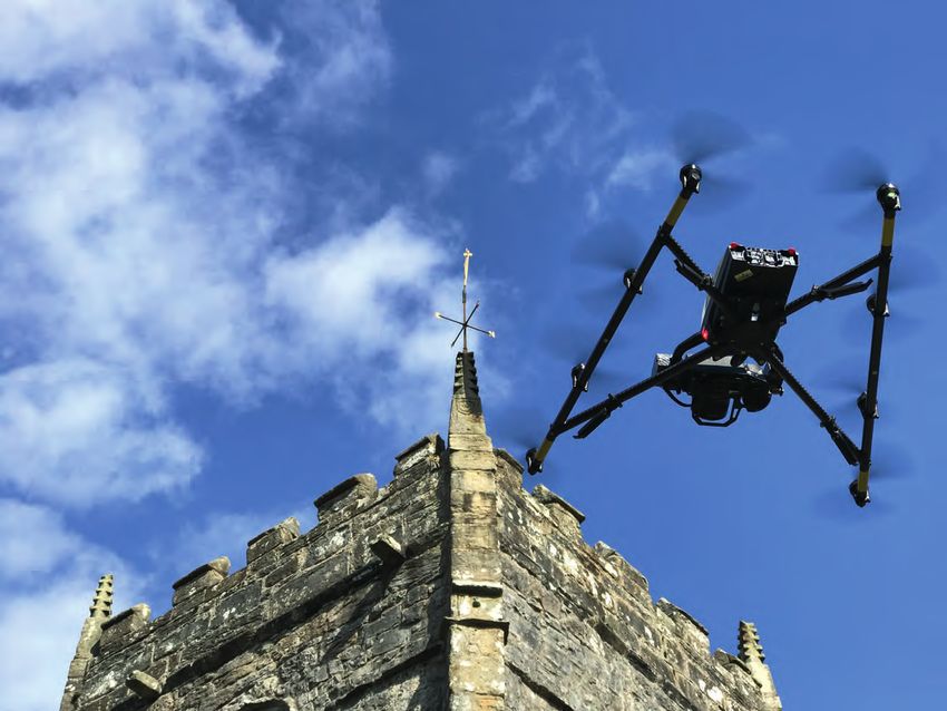
NEWS

             stuDy finDs volCano Cliffs Can                           in Brief
             affeCt monitorinG Data
             New research led by the University of East Anglia        Gatwick airport, the busiest single-runway airport in the world, is
             (UEA) has revealed that sharp variations of the          using aerial photography from Bluesky to plan long term development
             surface of volcanoes can affect data collected by        and growth. The high-resolution, map accurate imagery will feature
             monitoring equipment.                                    highly in the Airport’s soon to be published Master Plan.

             The surfaces of many volcanoes feature steep walls       DPR Construction has signed an enterprise-wide agreement with
             or cliffs. These are often part of calderas – large      skycatch creating a new model of unmanned aerial vehicle (UAV)
             craters left by a previous collapse – but can also       standardization and productivity available for all their project sites.
             be caused by the volcano ‘rifting’ – or splitting –
             or sector collapse, when part of the side of the         Bluesky has invested in the world’s most advanced combined Lidar
             volcano slides away. However, the effect of these        and camera system specifically designed for 3D city modelling and
             variations in landscape has not previously been          urban mapping. The Leica CityMapper incorporates the first hybrid
             considered in studies of surface deformation in          airborne sensor which can simultaneously capture vertical and oblique
             volcanic regions, even though they are a common          aerial photography as well as Lidar.
             feature.
                                                                      Whittles Publishing have announced a new textbook: unmanned
             In addition, monitoring equipment such as tiltmeters     vehicle systems for Geomatics, towards robotic mapping by
             are usually placed on caldera rims as they are often     Associate Professor Costas Armenakis and Professor Petros Patias.
             more accessible, especially if the caldera is lake-
             filled. Tiltmeters measure the horizontal gradient       As part of the Aerial Photography for Great Britain (APGB) contract
             of vertical displacement and can emphasize small         with the UK’s Geospatial Commission, Bluesky and Getmapping
             variations that go unnoticed using other monitoring      are providing free at the point of use Web Mapping Services (WMS) for
             methods.                                                 qualifying local government organizations. This allows APGB members,
                                                                      such as local authorities and national parks, to access and use high-
             Now researchers from UEA, the US Geological              resolution aerial photography – 12.5cm and 25cm – securely online.
             Survey and University of Bristol have found that
             features such as cliffs can cause a reversal in the
             pattern of deformation, leading to misleading data
             being recorded by the tiltmeters. Their findings are
             published in Geophysical Research Letters.             Technology, a space robotics start-       over 36,000 historiCal
                                                                    up.                                       raDarsat-1 satellite
                                                                                                              imaGes noW availaBle
                                                                    Testing a terrestrial drone and           The Canadian Space Agency and
                                                                    Lidar system at the Lofthellir ice        the Canada Centre for Mapping
                                                                    tube cave in Iceland, SETI Institute      and Earth Observation are making
                                                                    planetary scientist Pascal Lee said       RADARSAT-1 synthetic aperture
                                                                    that caves in the lunar or Martian        radar images of Earth available to
                                                                    environments could give shelter           researchers, industry and the public
                                                                    from inhospitable conditions              at no cost. The 36,500 images are
                                                                    on the surface: radiation,                available through the Government
                                                                    wide temperature swings and               of Canada’s Earth Observation
                                                                    micrometeorite bombardment.               Data Management System.

                                                                    Astrobotics was trialling its product     The RADARSAT-1 dataset is
                                                                    AstroNav, employing stereo vision         valuable for testing and developing
                                                                    and Lidar, aimed at autonomously          techniques to reveal patterns,
                                                                    exploring and mapping                     trends and associations that
                                                                    subterranean environments without         researchers may have missed
                               maPPinG on mars With                 GPS or prior maps.                        when RADARSAT-1 was in
                               liDar eQuiPPeD Drones                                                          operation. Access to these
                               CoulD BeCome a reality               A lunar or Martian drone would            images will allow Canadians to
                               Lidar equipped drones may            need to use thrusters, rather than        make comparisons over time, for
                               soon be mapping caves on the         propellers, but the Lidar sensor,         example, of sea ice cover, forest
                               moon and Mars, according to          autonomous control and scanning           growth or deforestation, seasonal
                               the SET Institute and Astrobotics    software could operate identically.       changes and the effects of climate

    6     May / June 2019

06-07-08-09_news.indd 6                                                                                                                         02-05-19 09:11
NEWS

     change, particularly in Canada’s
     North.                                      Commercial Drones Market Will Grow TO €38 Billion
                                                 The market for commercial drone
     This image release initiative is part       applications is growing at lightning
     of Canada’s Open Government                 speed. The sector presently generates
     efforts to encourage novel big              almost €16 billion of revenues, and this
     data analytic and data mining               figure is projected to nearly €38 billion by
     activities by users. Canada’s new           2024. At present, drones are being used
     Space Strategy places priority on           primarily in the energy, construction, and
     acquiring and using space-based             agricultural sectors, and these sectors
     data to support science excellence,         are expected to continue leading the
     innovation and economic growth.             charge in the near future. These are
                                                 some of the conclusions of the study carried out by the German research firm Drone Industry
     MDA Aids Indonesian                         Insights.
     Rainforest Preservation
     MDA has announced that its Forest           The most important uses made of drones involve aerial imagery, inspections, mapping &
     Alert Service (FAS) space-based             surveying. Examples include inspections of infrastructure, surveying of construction sites and
     capabilities have enabled Asia              monitoring crops. Drones can even identify and monitor crop diseases.
     Pulp & Paper’s (APP) pulpwood
     suppliers to more strategically             Between 2018 and 2024, the market for commercial drone applications will more than
     monitor forest cover loss in                triple. According to Kay Wackwitz, CEO and founder of Drone Industry Insights, there are
     conservation areas and meet their           several drivers behind this growth. First, the importance and usefulness of drones is finding
     commitment to stakeholders that             increasing recognition. “The commercial drone market is still in the early adopters phase, but
     conservation forest areas were              we are quickly transitioning to the early majority phase when it comes to adoption.”
     not cleared in connection with the
     production of their products. In less       Besides providing hard data, the research also identifies various trends. Wackwitz mentions
     than three years since MDA began            the example of drones that are being used to transport (medical) goods or even people.
     providing the monitoring service,           Such applications are going to grow exponentially in countries where there is little or no
     APP reports the losses of natural           infrastructure or where traffic in densely populated areas simply grinds to a halt. “In Rwanda,
     forest cover in their suppliers’ forest     a network has been established in which drones fly from one hospital to the other with
     concessions has dropped from                (often life-saving) medications; in the rainy season, roads simply become impassable. And in
     between 5-6% to just 0.06% of               mountainous Switzerland, a company named Matternet transports blood samples and other
     more than 600,000 hectares.                 emergency materials from and to hospitals, clinics, and laboratories.”

     The strategic partnership between           When it comes to transporting people, Wackwitz points to the ambitious plans unfolded by
     APP and MDA launched in 2016,               the taxi firm Uber. “Under the name of Uber Elevate, the company aims to build hubs on the
     enabling APP’s pulpwood suppliers           main traffic routes in the cities. The vision is to have a major hub with the capacity of up to
     to respond rapidly to detected              1,000 take-offs and landings per hour.” Partner cities such as Dubai, Singapore, Dallas and
     forest changes. Monitoring land             Los Angeles have been selected for that purpose, as traffic there is often a mess and there is
     cover changes in production areas           an urgent need for mobility alternatives.
     is essential for efficient operational
     planning and minimizes illegal
     encroachment, further protecting
     high-value forests.                       forest disturbances, in an area as       “Most of Kiribati’s islands average
                                               small as 0.5 hectares.                   less than two metres above sea
     Employing MDA’s RADARSAT-2                                                         level at present, and the country’s
     satellite, FAS provides near              TCarta to Supply                         110,000 inhabitants are among the
     real-time space-borne services            Satellite Derived                        most vulnerable to the effects of
     to deliver critical and timely            Bathymetry to the UKHO                   sea-level rise and the world’s first
     information to APP, typically within      TCarta Marine was contracted             potential climate-change refugees,”
     two days of data collection. Every        by the United Kingdom                    said Kyle Goodrich, TCarta
     24 days, the system monitors              Hydrographic Office (UKHO) to            President. “We expect to map
     approximately 3.8 million hectares,       provide a baseline dataset of water      5,000 square kilometres in total.
     which also comprises APP’s                depths and seafloor classification       Our seafloor maps will be used with
     pulpwood suppliers and the Giam           around the Republic of Kiribati.         other geospatial information by the
     Siak Kecil Biosphere Reserve.             Located in the Pacific Ocean, the        UKHO to recommend policies that
     RADARSAT-2 penetrates clouds              island nation is threatened by rising    will assist the Kiribati in planning for
     and precipitation to detect subtle        sea levels.                              and responding to this situation.”                               >

                                                                                                                            May / June 2019              7

06-07-08-09_news.indd 7                                                                                                                            02-05-19 09:11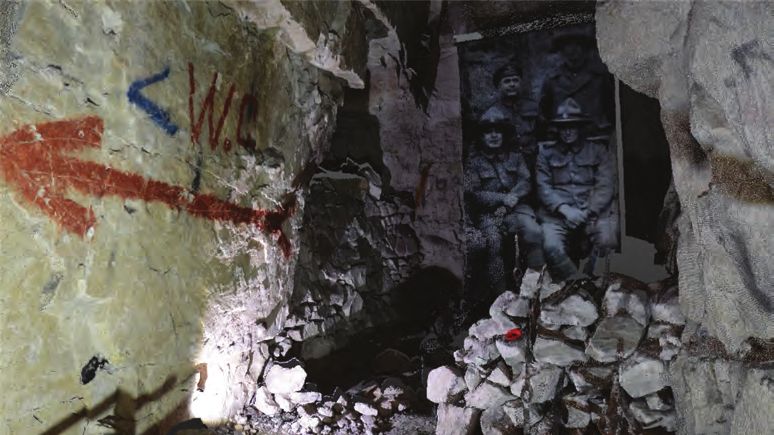
products

             Topcon GTL-1000 Total Station for                            Trimble XR10 Compatible with Microsoft HoloLens 2
             Vertical Construction
             Topcon Positioning Group has introduced a
             scanning robotic total station – the GTL-1000. A
             compact scanner integrated with a fully featured
             robotic total station, the system is designed to
             offer a powerful instrument for single-operator
             layout and scan on a single set up. Combined with
             ClearEdge3D Verity, it offers a new standard of
             construction verification workflows.

             The instrument includes a complete robotic total
             station that provides full-featured layout functionality
             with single operator control. The system is designed
             to build upon proven prism tracking and accuracy
             that allows operators to layout points in challenging
             construction environments. With the press of a
             single button, operators can then initiate a scan.
                                                                          Trimble has announced a wearable hard hat compatible device
             After processing with MAGNET Collage, the                    that enables workers in safety-controlled environments to access
             workflow is completed with ClearEdge3D Verity, an            holographic information on the worksite called the Trimble XR10 with
             advanced software tool that automates construction           HoloLens 2. In addition, an expanded set of Trimble software and
             verification.                                                services will be available to provide field-oriented workflows that leverage
                                                                          constructible 3D models and mixed reality to solve daily work tasks.
             Additionally, the instrument includes onboard
             MAGNET Field software designed to offer real-                The Trimble XR10 with HoloLens 2 is the first device created with the
             time field-to-office connectivity, and TSshield for          Microsoft HoloLens Customization Program and integrates the latest
             investment protection and maintenance.                       spatial computing technology into a certified solution for use with a hard
                                                                          hat for worker safety. With a wider field-of-view, improved usability and a
                                                                          unique flip-up viewscreen, the Trimble XR10 with HoloLens 2 combines
                                                                          state-of-the-art mixed reality and safe operation in restricted access
                                                                          work areas.

                                                                          The full solution provides even greater accessibility to 3D models by
                                                                          front-line workers. Field-oriented workflows enable broad adoption
                                                                          of mixed-reality for jobsite activities to improve efficiency, productivity
                                                                          and quality of work. Continued development of the cloud-based
                                                                          collaboration platform, Trimble Connect for HoloLens, is enabling
                                                                          workers in the field to get more value from constructible 3D models and
                                                                          transform daily work such as assembly and inspections.

                                TCarta won the open bid for supply      Earth-i Increases use of                  chains, their ACCORD programme;
                                of Satellite Derived Bathymetry         AI                                        and supporting smallholder
                                (SDB) to the UKHO to extract            In 2019, the Earth-i team will            coffee farmers in Africa – along
                                water-depth measurements and            continue to further advances in           with innovative and cost-effective
                                seafloor classifications, including     growing the integration of Artificial     ways to identify water leaks
                                habitat types, from multispectral       Intelligence (AI), Machine Learning       across pipeline networks covering
                                satellite imagery. In this project,     (ML) and Computer Vision into their       thousands of square kilometres.
                                TCarta is processing eight-band         service offerings.                        The power of their spatial data
                                DigitalGlobe WorldView-2 and -3                                                   fusion takes Earth Observation and
                                data predominantly, as well as four-    Earth-i is pioneering insights from       remote sensing from the academic
                                band WorldView-4 and GeoEye-1           space for commercial, government          firmly into the commercial market.
                                data to measure depths down to          and security clients. Examples
                                30 metres at a resolution of two        include Earth-i’s SAVANT service;         It also transforms the commercial
                                metres.                                 analysing global commodity supply         proposition by offering these

    8     May / June 2019

06-07-08-09_news.indd 8                                                                                                                            02-05-19 09:11
productS

     services on a pay-as-you-go or          Complementing the existing ZEB
     subscription service model. This        range of scanners, the scanner’s
     step-change lowers the barrier to       ‘walk-and-scan’ method of data         EVENTS
     entry for many commercial and           collection allows users to quickly
     security clients, so they can get the   and easily survey a property,
     answers they need without having        producing accurate data and high-      Got an event to list? Go to
     to invest heavily in geospatial         resolution photography.                www.geomatics-world.co.uk/events
     infrastructure and high volume
     machine automated processing            sensefly eBee X aDDs                   GEO Business 2019
     methods.                                miCasense Camera                       21-22 May 2019
                                             senseFly has introduced the eBee       London, UK
     Geoslam ZeB Pano                        X with the MicaSense RedEdge-
     hanDhelD sCanner                        MX camera, a dual solution             SPAR 3D Expo & Conference 2019
     releaseD                                for accurate and efficient crop        21-25 May 2019
     GeoSLAM, a geospatial mapping           analysis. By combining the eBee        Anaheim, California, USA
     technology specialist, has launched     X with the MicaSense RedEdge-
     its latest product offering property    MX, it enables farming, agricultural   Space Forum 2019
     professionals the ability to capture    science, forestry and environmental    21-22 May 2019
     floorplans and hi-res photography       protection professionals to gain       Luxembourg City, Luxembourg
     simultaneously.                         valuable multispectral crop insights
                                             more efficiently than with slower      GEOINT 2019
     The ZEB PANO, a handheld SLAM           multirotor drones.                     2-5 June 2019
     (simultaneous, localization and                                                San Antonio, Texas, USA
     mapping) scanner and panoramic          The RedEdge-MX multispectral
     camera, has been developed              camera is rugged and built to          ISPRS Geospatial Week 2019
     for the property sector. SLAM           last. Capturing red, green, blue,      10-14 June 2019
     technology is widely known for          near-infrared and red-edge spectral    Enschede, the Netherlands
     its use in the automotive industry      bands, data from this sensor can
     for self-driving cars, but the          be used to generate true colour        IoT Week 2019
     technology has applications far         composites, basic crop health          17-21 June 2019
     beyond that.                            indexes and advanced analytical        Aarhus, Denmark
                                             tools like flower identification and
     Capable of capturing 43,000 data        weed detection.                        TUS Nordics 2019
     points per second and high-                                                    18-20 June 2019
     resolution panoramic imagery at         The senseFly eBee X with               Malmö, Sweden
     the same time, the ZEB PANO             MicaSense RedEdge-MX (including
     stores the exact location of each       plug-and-play camera integration       GeoInformation for Disaster Management
     panoramic image enabling quicker,       kit, Downwelling Light Sensor (DLS     2019
     more accurate, and less intrusive       2), and Calibrated Reflectance         3-6 September 2019
     property surveys. Property agents       Panel) is available for purchase via   Prague, Czechia
     can use this information to create a    senseFly distribution partners. It
     floorplan and property descriptions     is priced at US$19,800 excluding       INTERGEO 2019
     in considerably less time.              shipping and importation taxes.        17-19 September 2019
                                                                                    Stuttgart, Germany

                                                                                    11th International Symposium on Digital
        in Brief                                                                    Earth 2019
                                                                                    24-27 September 2019
        maptek has released a cold climate model of its award-winning               Sesto Fiorentino, Italy
        mobile Sentry system for stability monitoring. The system allows for
        continuous, reliable measurements of ground movement no matter the          Commercial UAV Expo Americas 2019
        environment.                                                                28-30 October 2019
                                                                                    Las Vegas, Nevada, USA
        hemisphere Gnss have announced a single-frequency, multi-GNSS
        Vector V200 smart antenna with integrated Atlas L-band designed for
        general marine applications and markets.

                                                                                                              May / June 2019         9

06-07-08-09_news.indd 9                                                                                                         02-05-19 09:11
POLICY WATCH                                                                                                             by JAMES KAVANAGH

           World Bank Conference Tackles Key
           Issues of Land and Poverty

                                                       This edition of policy watch is         view?objectId=44498725). This video is designed to give
                                                       mainly dedicated to the annual          members a quick insight into the multi-faceted world of
                                                       World Bank 2019 land conference         policy, education, journals (including GW), standards, best
                                                       but there are still a few RICS          practice, collaboration and events that we work within.
                                                       specific bits and bobs to update
                                                       you all on.                             World Bank – Catalysing Innovation
                                                                                               More than 1,500 delegates from across the globe and
                                                       The RICS Geo Evening Lectures           from all sectors of the land profession, were treated to
                                                       series added an extra date:             an enormously successful World Bank Land & Poverty
                                                       Thursday 9 May, 18:00, at UEL,          Conference 2019, held at the World Bank HQ in the
                                                       Stratford campus which will focus       heart of the imperial splendour of Washington DC,
                                                       on Survey4BIM issues.                   USA. It really does require an expansion of my stock
             James Kavanagh, Director of the RICS                                              of superlatives, and that’s quite large, to adequately
             Land Group.                                RICS Insight output is ramping         describe this milestone annual event. Suffice to say
                                                        up as we move into the summer          that it is a privilege to attend and an honour to speak
                                   months (the end of the RICS business year) with a           at such an event. This was the 20th anniversary of
                                   brand new Insight on the ‘Use and Value of Commercial       the land conference and it has been led, indeed built
                                   Property Data’ (www.rics.org/uk/news-insight/research/      from scratch, by Klaus Deininger, World Bank Lead
                                   insights/the-use-and-value-of-commercial-property-          Economist, Development Research Group, (very ably
                                   data/). This paper aims to discuss the benefits of          supported by Thea Hilhorst).
                                   and challenges to an increasing use of data in the
                                   commercial property market. It considers not only its       The conference now runs over five days, with hundreds
                                   availability and quality but also the skills needed by      of very high-level peer reviewed papers, 13 parallel
                                                                                               sessions, poster sessions, daily plenary sessions,
                                                                                               master classes and social events. This really is a
           It considers not only its availability                                              must attend event for anyone involved in any aspect
                                                                                               of the land process from mapping to valuation to
           and quality but also the skills needed                                              acquisition, taxation, transfer and development and is
           by surveyors to recognize its uses and                                              very heavily supported by UN Agencies UNFAO and
                                                                                               UN Habitat. It is probably the only arena that brings
           maximize the value in analysing it…                                                 together geography, social justice and economics
                                                                                               and whilst a rightful focus is on issues of tenure rights
                                   surveyors to recognize its uses and maximize the value      (gender especially), the question of how we arrive at
                                   in analysing it, but also with the ownership of data, its   an equitable form of recognizing legitimate land rights
                                   security and regulation, and it makes predictions and       is an ongoing conversation. World Bank is always very
                                   recommendations for the future of a property world full     keen to move away from ideological drivers and look
                                   of accurate, easily available data.                         at empirical forms of evidence-based solutions and
                                                                                               refreshingly is very honest in the way that it evaluates
                                   There is also a forthcoming Insight paper on ‘Drones/       projects and interventions. An excellent policy paper on
                                   UAVs – an evolving technology’. We are aiming to            ‘Using Satellite Imagery to Revolutionize the Creation of
                                   launch this new output at GEOBusiness 2019. This            Tax Maps (http://documents.worldbank.org/curated/
                                   insight will give a broad view on a rapidly emerging        en/305651536648310984/Using-Satellite-Imagery-to-
                                   technology, its multiple applications with surveying,       Revolutionize-the-Creation-of-Tax-Maps) underlines this
                                   sensor and platform types, case studies, and most           concept and from an RICS viewpoint helps to synergize
                                   importantly underline the need to adhere to national        how geospatial enables economic development and
                                   and regional legislation and regulatory structures.         functioning land/property markets.

                                   Again, I would commend to you all our latest RICS           RICS was heavily involved in this year’s conferences
                                   video (https://communities.rics.org/connect.ti/Wikigeo/     with several posters, papers, sessions and for the first

    10 May / June 2019

10-11-12_ricspolicywatch.indd 10                                                                                                                     02-05-19 09:11
Policy watch
time a master class. We also took the opportunity mention of Blockchain during
to visit Georgetown University and speak at a local the event (www.conftool.com/
members CPD evening (RICS has around 120 landandpoverty2019/index.
members in the Washington DC region). php?page=browseSessions
&form_session=547&presenta
Conference Highlights tions=show), and much more.
RICS produced a special edition of the Land Journal The second day opened with
for the conference (www.rics.org/uk/news-insight/ strong session on registries of
publications/land-journal/) which focussed on the value the future – featuring HMLR
of natural capital, as usual the Land Journal proved and Lauren Tombs on the
very popular and two boxes (300 copies!) disappeared new Digital Street initiative
as quickly as we could put them on the journal in the UK, Mark Reichardt
distribution table. from the Open Geospatial
Consortium closed out the
The opening Monday has now become a full day of morning session (remember
often riveting sessions on a variety of land related 1 of 13 parallel sessions!)
subjects. An afternoon session featured a heavyweight by calling for a new global
session on the new World Bank Land in the World initiative linking land registries.
Bank’s new Environmental and Social Framework The next session of interest
(https://www.conftool.com/landandpoverty2019/ focussed on Blockchain and really brought into
sessions.php) of great interest when considering the focus how far industry implementation is (Dubai Land
ILMS ‘due diligence’ framework that we presented later Authority have implemented a full Blockchain enabled
that day and an opening plenary on ‘Linking satellite real estate market) ahead of academia and even for
and administrative data for land economics research that matter regulation. Tokenisation (google it!), land
and practice’, led by Adam Storeygard, Tufts University, transfer and security were high on the agenda, this
United States of America. The opening day also was a packed session and an indication of the strength
featured a poster session on the mezzanine level which of the conference in bringing disparate professionals
featured ILMS (amongst numerous other posters). together.
Indeed, the poster sessions are increasingly active
and busy and last for nearly 48 hours – a great way to I also attended sessions on land markets at the rural-
highlight a new initiative or project. The posters are also urban fringe, enforcing adherence to standards for
close to the exhibition space (small for anyone used to large land-based investment – now, this was a very
geospatial events, but cosy). active session and featured a new release from UN
FAO on due diligence for lawyers in land acquisitions.
Tuesday saw the start of the 13 strong parallel This important UN FAO output is directly connected
sessions, RICS was particularly interested in the GIS to the due diligence ILMS framework for surveyors.
derived Automated Valuation Modelling sessions and Wednesday saw an important session on Land
the morning also featured excellent sessions on fit Governance in the Arab states, UN Habitat GLTN >
for purpose land administration featuring Prof Stig
Enemark, and Brent Jones from ESRI. The highlight
for RICS was Fiona Mannix delivering a 1st paper
on natural capital (www.rics.org/uk/news-insight/
research/insights/value-of-natural-capital-the-need-for-
chartered-surveyors/).
There were also sessions on making property tax
systems transparent and equitable, implementing urban
value capture, the use of UAVs, and low-cost ways
to establish cadastral systems – not the first nor last
May / June 2019 11
10-11-12_ricspolicywatch.indd 11 02-05-19 09:11POLICY WATCH
also used this session to refocus their strategy on development compensation speculation (a major issue
land-based financing and the provision of affordable in Korea) and then Jean Brice Tetka, Transparency
housing. The day was wrapped up by our colleagues International, spoke on land acquisition systems that
in CLGE & NSPS with a session on professional ethics help to combat corruption, namely by breaking down
the processes and highlighting the gaps and steps
that introduce risk and the opportunity for corruption.
The new technology is being tested in Zambia and
RICS was particularly interested in Sierra Leone. Maxwell Mutema FRICS, then took
the stage to speak on valuation and compensation
the GIS derived Automated Valuation issues in Zimbabwe’s land reform programme. This
Modelling sessions… paper highlighted the enormous post-colonial issues
still at play in sub Saharan Africa and the economic
devastation wrecked by the land reform programme,
and surveyors – this session also featured the Global the mis-valuation of compensation (based on
Day of the Surveyor award which went to Loránd improvement issues) and the western misconception
Eötvös from Hungary. (or indeed propaganda) that the return of vast tracts
of land from white farmers to local people was
Thursday featured several sessions on crowdsourcing agriculturally disastrous. Mismanaged and highly
geospatial and land data, and I was lucky enough to political this is still a major issue for the nation to
chair a session on data to determine compensation for deal with post Mugabe. The session finished with an
land acquisition. The session started with a Korean LX extremely lively debate; indeed, it wasn’t easy to clear
presentation of the use of UAVs to help combat land the room for lunch!
Thursday finished on capacity and training issues,
more geospatial special sessions and sessions on
dispute resolution. I should also mention that the main
auditorium was filled with plenary sessions during the
lunch breaks, a good one was given by geo-legend
Jack Dangermond who mentioned the term cadastre-
cide and highlighted the known fact that land registries,
mapping agencies and surveyors are always targeted
during conflicts. One of the first things Daesh (ISIS)
did in Mosul was burn all land and property records.
Thursday also saw the closing plenary which featured a
celebration of a very satisfying week of interaction and
intellectual debate.
RICS MaSTER CLaSS
On Friday, RICS took part in a master class on how
land professionals can contribute to making the SDGs
a reality, an open and lively session featuring several
representatives from across the land professions
including Nigeria, RICS, Ordnance Survey International,
and FIG YSN with Diane Dumashie in the chair. I
would commend the recent RICS output on the SDGs
(www.rics.org/uk/about-rics/responsible-business/un-
sustainable-development/). The entire Friday was taken
up with masterclasses and two major visits to local
land registries or even the national geospatial office in
Washington DC. I should also note that social media
interaction was intense at this conference with 100’s
of posts on Twitter #landconf2019 but what a week!
All presentations and papers are available from https://
www.conftool.com/landandpoverty2019/sessions.php
an enormous resource of knowledge and expertise.
12 May / June 2019
10-11-12_ricspolicywatch.indd 12 02-05-19 09:11by GORDON JOHNSTON GEOMATICS PGB CHAIR
Five Hundred Years on and Still Exciting Times
It was 500 years ago that the Portuguese explorer leverage support and resources on
Ferdinand Magellan organized a Spanish expedition the basis of the benefits? This might
to the East Indies that resulted in the first not be as obvious as it should be
circumnavigation of the world. Sadly, he died in the but just think about that hotel room
Philippines (from a poisoned dart) and the voyage you’re about to book for the summer.
of discovery was completed by Juan Sebastian You can have the garden view or,
Elcano. It was perhaps dangerous, but it was also a for a premium, an ocean view. So
very exciting time, as it is today. immediately, before you even arrive,
there’s a value to this water, even if
Standards and Guidelines for our profession are only to look at it. So as professional
something we sometimes take for granted or, as surveyors we have a role to play in
specialists and experts in certain systems and data, establishing the limits and boundaries
we might forget that many do not have knowledge, of our seas and oceans but also in Gordon Johnston, Chair of the RICS
and may not be aware that any guidance is available developing standards for the datasets Geomatics Professional Group. Gordon
or that some standards exist. The RICS works across as part of a Marine Spatial Data welcomes your comments and thoughts
a broad spectrum of geospatial and related disciplines Infrastructure but also across all types so please email to the following address
and in recent years the development and maintenance of acquisition, management and web geochair.rics@gmail.com
of supporting documentation has benefitted from our enabled services to make the data
cooperation and collaboration with our colleagues in available for the common good.
other professional bodies. The recent land & resources
video (https://communities.rics.org/connect.ti/Wikigeo/ The UK government has recently announced a further
view?objectId=44498725&exp=e1) highlights this effort free release of some 130 terabytes of data in an effort to
and our recent progress. Looking forward, we are promote its use in renewed offshore energy exploration
planning a number of papers and documents including and development. Quite impressive and although perhaps
the AUV (Drone) Insight Paper also mentioned in the a somewhat obvious attempt to generate interest in
Policy Watch column.
Further afield both in terms of operation and subject How can we manage the seas if
matter, the recent FIG/IHO/ICA Standards board
meeting in April recognized another set of Hydrographic
we have yet to create some decent
Surveying and Nautical Cartography courses against the mapping?
International Standards of Competence for Hydrographic
Surveyors and Nautical Cartographers. The Australasian future offshore oil & gas licence rounds across the UK
Certification Scheme was also recognized. With Continental Shelf, it is surely only a matter of time before
countries now beginning to include and adopt spatial some of the more media savvy energy companies start
strategies and planning, finally the seas and oceans have to release their data in order to show their willingness to
also become an important, if not an absolutely critical further our understanding and knowledge of our seas.
arena, for developing national aspirations and securing
various sources of energy, food and a sustainable Technology is a key enabler, and also in support
habitat. With the expected value of business associated of global exploration are the Global Navigation
with our seas and oceans increasing from some 1.5 Satellite Systems (GNSS), and now in 2019 (since 27
trillion to almost 3 trillion by 2030 there are plenty of December 2018 in fact), we have the fully operational
opportunities to exploit, manage and monitor, but only if BeiDou Navigation Satellite System from the Chinese
we have established some form of initial baseline data to government. So, with four different GNSS to pick and
begin with. How can we manage the seas if we have yet choose from we are truly in a period of strategic spatial
to create some decent mapping? enlightenment and data availability. If you’re quick, you’ll
see some units at GEOBusiness 2019 that should be
Nevertheless, there is a value which is becoming able to demonstrate the current GNSS performance.
increasingly important. How do we measure this and So, 500 years on, it is still exciting times.
May / June 2019 13
13_ricschairscolumn.indd 13 02-05-19 09:11UNDERCURRENTS by MALCOLM DRAPER WITH STEPHEN BOOTH
Errors, a Soil Expert and Celebrations
First of all, apologies to this is another of those ‘surveyors versus OS’ disputes
readers for our failure to between accurate GPS surveys and representative
provide an Undercurrents in mapping. This could become a flashpoint if Wales goes
the last issue. Pressure of independent after Brexit.
work hit both of your scribes.
However, from all accounts we Not so Silent Witness
hear that most surveyors are Ever wondered whether all that high-tech laboratory
pretty busy and tend to catch analysis that goes on in crime dramas is really true?
up on their journal reading Silent Witness is particularly saturated with it. Indeed,
over the holiday period. So, the star Emelia Fox, recently presented a programme
without further ado, let’s get which reviewed the historic murders of Jack the Ripper
started on what we’ve been using modern techniques. In the meantime, if you’re
up to. a ‘who dunnit?’ fan of writers like Ian Rankin or Val
Malcolm Draper, Owner of Rentalength McDermot they are riddled with forensic examinations
Public Footpath through of crime scenes. Where do they get their technical
House information from? Enter the Royal Geographical
A couple of stories in the newspapers have attracted Society, which recently heard from crime scene
our attention. A couple in Newquay, UK, inherited a investigator, Professor Lorna Dawson CBE. She is
former council house, which they have been struggling an honorary professor in Forensic Science at Robert
to sell. It seems that when it was built as a council Gordon University, an expert witness and an adviser
house in the 1940s the local council failed to get the to the Scottish Government. She is very much at the
Land Registry map to record a revised alignment to interface between science and fiction. Her work has
a public right of way which otherwise bisected the been characterized in crime writers’ books and in TV
property. The mistake has caused quite a headache dramas like Shetland, Rebus and Silent Witness.
for the owners as prospective purchasers were
unable to get loans on the property with a footpath Her lecture was one of the best for some time at the
running right through the middle of it. The council RGS. Give Prof Dawson an old muddy plimsoll or a
say they’re working on it. Still, it’s better than that old mud encrusted tyre and she’ll identify to within a few
song, “The railroad runs through the middle of the hundred yards exactly where in the country it has been.
house...” She can even track down which beach a few grains of
sand are from. Her work helped ensure justice in 2004
Wales to Give 41 Acres to England? for two girls murdered in 1977 before DNA could be
Our second tale of mapping woe is more serious for analysed.
those who care about national boundaries. Two Welsh
surveyors believe that Ordnance Survey’s original Fortunately for Lorna and her colleagues, back in
survey from 1887 misplaced the border with England the 1970s a nationwide campaign to analyse soils
by 39 feet and thereby deprived England of some 41 and place the results within a grid has resulted in a
acres of land. Ordnance Survey however, remains benchmark reference source, now incorporated within
adamant that the border is correct and that the two a GIS. Her skills and knowledge were even able to
surveyors were working from out-of-date maps and trace how the carcass of a small dead bird ended up
in any case, ‘there is no legal mechanism in place for in a supermarket pack of salad leaves. She found the
reviewing the boundary between England and Wales’, leaves came from no less than five different countries,
which would require primary legislation to review. but narrowed down the avian’s remains to one Spanish
farm where anti-bird netting had been torn letting the
The surveyors remain convinced that they are correct poor creature in.
based on the position of the watershed and a series
of heights recorded of Twyn Llech mountain which Of course, it’s not just soil but also DNA. She reminded
they have found is further into Wales than recorded by her audience that it they shook hands that evening
Ordnance Survey. Undercurrents can’t help feeling that their DNA could be transferred to other objects they
14 May / June 2019
14-15-16_undercurrents.indd 14 02-05-19 09:11H UNDERCURRENTS
for someone who had disappeared. The extent of the
property was grossly under recorded by Google and
the police failed to find a body for 18 months.
50 Years Marked in Albert’s Shed
Congratulations to the Chartered Institution of Civil
Engineering Surveyors (CICES) now celebrating
their 50th anniversary since founding in 1969 as
the Association of Civil Engineering Surveyors.
Undercurrents was honoured to be invited to the
celebratory luncheon at the mysteriously named
Albert’s Shed in Manchester. Despite the odd title,
which bears no resemblance to Undercurrents’ own old
grey shed, the venue was splendid with views to a fine
touched. So, was it possible to commit a perfect modern landscaped square and ultra modern buildings
murder? Not yet was her reply. and to the other side, a strong reminder of the city’s
Victorian industrial heritage as red-bricked arches and
GPS Knows Boundaries viaducts supported modern trains and trams whizzing
Undercurrents is delighted to see that leading boundary past.
expert David Powell is moving with the times and has
acquired a thoroughly modern GPS system. 50 Years in Survey
Another less formal gathering, to which Undercurrents
Can Lasers Do It All? was invited, celebrated Bill Rees of Land and Bill Reece recently
Former Civil Engineering Surveyor editor (1975-96) Engineering Services – 50 years as a surveyor. We marked 50 years in
Stephen Booth was recently asked to draft 500 or rallied in the Barrow Boy & Banker for a very convivial surveying. Here, he is
so words on his recollections of the early days of the evening. Bill had two of his sons with him but not the with the youngest of
publication. During his researches, he came across youngest, plus Gary Jackson and Roland Thompson his three sons.
an excellent letter in the journal from November 1980 from 360 Surveys,
from the late Eric Ratcliffe lamenting the ignorance of Pat Collins and Bob
engineers. On a tunnelling project, the engineer told Szczerbicki.
Eric there was no longer any need for theodolites as
lasers could do it all. Eric replied by explaining to him Checking
that laser beams are basically bits of red string, which Everest
couldn’t be positioned without theodolites! The Times reports that
a team of surveyors
Eric Ratcliffe was the chief surveyor on the Channel from Nepal have been
Tunnel. As the two tunnelling teams got ever closer training for two years
a small horizontal drill was driven through to assist to check the height
in checking the final closure. To check for vertical of Mount Everest,
alignment, Eric suggested a simple water level – filled following reports that
with red wine. Alas, whilst his French colleagues it had slipped after
welcomed the idea, the Customs & Excise people Nepal’s devastating
stopped it as no duty had been paid. earthquake in 2015,
which killed some
Reprimand for Google Users 9,000 people. Everest
While Google Maps are excellent for a desktop recce has of course been
ahead of a site visit, they should not be relied on for measured several
much else. Australian police were reprimanded recently times since the Indian
for relying on Google to search a property whilst looking Survey recorded a >
May / June 2019 15
14-15-16_undercurrents.indd 15 02-05-19 09:11UNDERCURRENTS
height of 29,029 feet in 1954. More recent expeditions the late Gary Covington, a regular contributor to these
backed by Leica and Trimble using GPS, have recorded columns. We love this great picture of the man, nicely
an additional two metres; Undercurrents seems to capturing him beside a trig point which he constructed
recall that the Trimble expedition involved using yaks to on his property on Kangaroo Island off the South
transport the receivers, probably not all the way to the Australia coast. Inscribed into the top are the words “To
summit. old surveyors past and present” with the latitude and
longitude.
Miscellany
We recently came across a list of forecasts which
proved monumentally wrong. Many of these are well
known but Undercurrents’ favourite is King William I of
Prussia on the subject of trains, who confidently said,
“No one will pay good money to get from Berlin to Undercurrents is a joint column by Malcolm Draper
Potsdam in one hour when he can ride his horse and and former GW editor Stephen Booth. Do feel
get there in one day for free”. Clearly his majesty had free to drop us a line with any (vaguely!) relevant
not succumbed to modernity’s time is money. surveying stories to: rentamalc@aol.com. For the
sake of a good story we are always prepared to
Obituary change names, details etc to protect the innocent
Although Undercurrents did not know Dennis Shearing, as well as the guilty.
we shared many friends and acquaintances including
Peter Hopkin MRICS, writes: Bruce was climbing church towers and occupying distant trig
points with his beloved T2, and he introduced, and inspired
Dennis Shearing 1944 - 2019 me, to the surveying world.
Former Clyde and Fairey surveyors around the world are
mourning the passing of Dennis ‘Bruce’ Shearing, who has Two projects in particular spring to mind; on a mapping project
died at the age of 74 after a short illness. in Indonesia, as part of the Government’s Transmigration
Initiative, agricultural settlements were to be built in remote
In the late 1970’s and 1980’s, Bruce was one of three forested areas. Much of the landscape was boggy, and I
surveyors (Alan Johnson and Gary Covington being the two can vividly recall a photograph of Bruce traversing through
others) whose overseas knowledge and experience dominated the swamp forest, up to his waist in water that would have
the company. As a young surveyor starting in the industry, I been busy with plenty of wildlife, much of which would have
was one of several who listened with awe to their tales from been long, thin and loaded with attitude. At a similar time, he
Africa, Asia and the Antarctic. Bruce was perhaps the best surveyed inside a British sewer chamber, ironically in the City
travelled; an Australian who had made his home in Britain, of Bath, chest deep in a vibrant mixture of solids and liquids,
but who would work anywhere, and had done so. He had where we first learnt the meaning of the word ‘fatball’.
an amazing life; from being one of the last people to fly into
Cambodia before it fell to the Khmer Rouge, to self-building an Bruce was happiest with a T2, a HP42 programmable
amazing farm in a remote location overlooking the Southern calculator, and a sharp pencil, but as the survey industry
Ocean, with his own personal trig pillar. moved from observations into data, and he developed an
uncanny knack of crashing every computer he touched, he
He was at home in moved aside into organic farming in his beloved Australia. Not
any environment, content with just buying a plot of land, he had to build a house
either building the as well, which he did from scratch, dynamiting the post holes
first geodetic control and erecting a two-storey house that was one of the most
network in Bahrain spectacular wooden frame houses imaginable. The organic
or performing large farm was worked by visiting enthusiasts from around the world,
topo or engineering and the short obituary on the Woofers website (https://wwoof.
surveys such as a com.au/the-passing-of-a-wonderful-host/) shows that the
bridge in Nepal. I first deepest respect from his fellow surveyors is shared by many
met him on a project others.
in Lincolnshire; while I
was using Leica’s first He was an inspiration to many around the world and is deeply
total station, the TC1, missed.
16 May / June 2019
14-15-16_undercurrents.indd 16 02-05-19 09:12 HERITAGE MAPPING
A Challenging Cliff Top Survey in
??
Tintagel – Trimble SX10 Meets the Challenge
Rugged and beautiful, Tintagel is set high on the North Tackling a Challenging
Cornwall coast where the jagged headland reaches out Site
into the Atlantic. It is one of English Heritage’s most visited With the control established in
sites. This is despite the link between the headland and the visible positions, Jordan was able
ruins of the 13th century castle, the legendary home of King to use the SX10 safely from the
Arthur, being a challenging scramble up and down hundreds footpaths by making full use of
of steps and via a modest wooden bridge. its 600m+ range. Additionally, he
was able to scan selectively to
speed up the process. The SX10
Access is set to become tolerance for a deliverable that would is driven by Trimble’s Access
considerably easier thanks to a £4m include scan to scan comparisons software on a tablet which means
project which will see a new 72m and a colourised point cloud. he could draw a polygon over the
footbridge constructed high above Greenhatch Engineering Manager, tablet’s live video feed enabling
the current wooden structure. Due Jordan Knight, therefore felt that him to define the scan area and
for completion in Spring 2019, the scan accuracy was the number one density. In each case the polygon
new bridge design is based on a priority along with scan range due scans were overlapped to check
prize-winning concept submitted in a to the number of site set-ups that the accuracy of the set-ups typically
competition run by English Heritage. would be required because access achieving a difference of 1.5mm
The new bridge will be based on a would be restricted to footpaths over 100m.
design that has one cantilever on the for health and safety purposes and
Cornish mainland and another on the limited time. Scan speed would also Jordan also used the SX10’s built-
island fortress with an aim to recreate be important along with equipment in VISION technology camera to
an historic route into the castle. reliability (there would be only one colourise the point cloud, clarifying
chance to carry out the work), and the different types of vegetation on
Ensuring Accuracy finally, equipment portability for a and around the cliffs.
Contracted by English Heritage job which would see them climbing
to carry out the dual tasks of hundreds of steps and kayaking Finally, with just one instrument
monitoring around Merlin’s Cave through Merlin’s Cave. required for the survey work, the
(before and after the bridge’s portability of the SX10 meant that
construction) and scanning the Jordan had already used the Trimble they could wrap it sufficiently in
cliff faces for erosion purposes, SX10 scanning total station on a waterproof covering to ensure
is geospatial survey company previous monitoring jobs and felt it its safety whilst kayaking through
and laser scan specialists, The would be the best solution to meet Merlin’s Cave - not normally
Greenhatch Group. the challenges. accessible by the public.
Greenhatch surveyors were already Over an initial two-day period, Once the job was completed, the
familiar with the site and were survey monuments were installed scans were automatically registered
therefore aware that the setting using a Trimble S9 high-accuracy and assessed for quality. The 5mm
would be particularly challenging total station combined with eight accuracies specified by English
to work in with fast rising tides, hours of static GNSS observations. Heritage were easily achieved and
inaccessible areas due to the Back in the office, Jordan carried the survey delivered on time.
ravines and a very tight deadline out a least squares adjustment
with the imminent shut down in the Trimble Business Centre
of the site in preparation for the software (TBC) to ensure the
construction work. reliability of the network which
was used to undertake repeated
English Heritage required the work measurements of the areas of The Trimble SX10
to be carried out to within a 5mm interest using the SX10. near the old bridge.
May / June 2019 17
17_achallengingclifftopsurvey.indd 17 02-05-19 09:12You can also read