Chapter 2: A description of the Gold Coast area
←
→
Page content transcription
If your browser does not render page correctly, please read the page content below
Chapter 2: Description: GCCC SoER 1997

Chapter 2: A description of the Gold Coast area

This chapter presents a general description of the Gold Coast. This provides a
background against which the data that are presented in the following chapters can be
viewed. The following information summarise the unique position the City of Gold
Coast holds in Southeast Queensland and highlights the responsibilities the Council and
Community have as they manage the City’s development.

2.1 A brief history of human settlement and land use on the Gold Coast

Today, the Gold Coast is a city of some 350,000 people and occupies 145,100 ha
(1,451km2) of Southeast Queensland; from the QLD-NSW border in the south, to the
Logan River and Southern Moreton bay in the north, and from the coastal beaches in
the east to the crest of the McPherson and Darlington Ranges in the west. Figure 2.1
shows the area of the City of Gold Coast and its population centres.

For many thousands of years the Gold Coast area has been the traditional home to
some 4000 Aboriginals (Jones 1988 p.18) of the Yugambeh language group. The
group was represented in the Gold Coast mainly by the Wangerriburra (Albert Tribe),
the Kombumerri (Nerang), the Bullongin (Coomera), Minjunbal (Tweed), Birinburra
(Numinbah), and the Gugingin (Logan) family groups (Jones 1988). The population of
Aboriginals on the Gold Coast had declined from these earlier times to a present
population of around 1600 in 1991 (Taylor 1996).

Since the 1820s timber getters were moving into the area from northern NSW seeking
red cedar (Toona ciliata). However, by the 1860s settled agriculture was emerging
along the rivers. The major crop was sugar but cotton was also grown. The failure of
cotton production and the crash of the world sugar price in the 1890s saw both of
these land uses decline and dairying increase. This brought a need for more pasture
which led to extensive clearing of the native bush. Consequently by the turn of the
century significant areas of the vegetation in the hinterland had been cleared with the
exception of more remote or inaccessible areas.

During this period of development the waterways of the coast were considered vital
transport links for the local economy. They were used to transport the timber and
produce to markets in Sydney and Brisbane. Townships began to grow at key
junctions of the river and local roads, such as Nerang and Beenleigh, and with the
ocean, Southport and Coolangatta).

In this agrarian society the coastal beaches and coastal heath (wallum) were considered
unproductive and of little value. However, from around the 1890s to the early part of
the 1900s the Gold Coast was emerging as a tourist destination. This was partly due
to the patronage of the area by the Governor of Queensland and an increasing
recognition of the natural assets of the area for bushwalking and surfing. Popular
resort areas were Burleigh Heads, Coolangatta, Southport and emerging was the
settlement of Elston, later renamed Surfers Paradise.

                                         2-1
Chapter 2: Description: GCCC SoER 1997
LOGAN CITY
REDLAND SHIRE
CORAL
EAGLEBY SEA
BEENLEIGH
ALBERTON
HOLMVIEW
BRISBANE
WOONGOOLBA GOLD COAST
QUEENSLAND
NEW SOUTH WALES
YATALA
ORMEAU
JACOBS WELL
PIMPAMA
SOUTH
STRADBROKE
CORAL
ISLAND
COOMERA
HOPE ISLAND
UPPER COOMERA
PARADISE POINT
HOLLYWELL
Coombabah
HELENSVALE
Lake
OXENFORD
COOMBABAH RUNAWAY BAY
BIGGERA WATERS
ARUNDEL
LABRADOR
PARKWOOD
BEAUDESERT SHIRE MAIN
BEACH
ERNEST
SOUTHPORT
MT NATHAN MOLENDINAR
NERANG
ASHMORE
SURFERS
BENOWA
PARADISE
BUNDALL
CARRARA BROADBEACH
GILSTON BROADBEACH
WATERS
CLEAR
ISLAND
LOWER WORONGARY WATERS
BEECHMONT MERMAID
MERMAID
Hinze Dam MERRIMAC BEACH
WATERS
MIAMI
ADVANCETOWN
ROBINA
BURLEIGH WATERS
MUDGEERABA
BURLEIGH HEADS
SE
A
PALM BEACH
REEDY CREEK
ANDREWS
ELANORA
CURRUMBIN
BONOGIN TUGUN
CURRUMBIN
TALLEBUDGERA WATERS
NUMINBAH VALLEY
BILINGA
COOLANGATTA
TALLEBUDGERA VALLEY
TWEED SHIRE
SPRINGBROOK
CURRUMBIN VALLEY
QUEENSLAND
NATURAL BRIDGE
NORTH
0 5000
NEW SOUTH WALES
Metres
Figure 2.1: Locality map of the City of Gold Coast
2-2Chapter 2: Description: GCCC SoER 1997
Land was advertised for sale in the Surfers Paradise Estate in 1917, some blocks with
ocean frontage and others with deep-water frontage onto the Nerang River. From
around this point in time, water-based recreation in particular, and the environment in
general, appear as key elements to the economy of the area.
2.2 Landscapes and soils (geology and geomorphology): Some very ancient
history
2.2.1 Landscapes
The topography of the Gold Coast consists of a coastal plain that includes beaches and
dunes, river deltas, bays, estuaries and wetlands, rolling foothills and low mountain
ranges. Much of the eastern portion of the City is coastal plain (less than 10m above
sea level). The topography rises through rolling foothills to the scarps of the ranges to
the west (up to 1010 m above sea level at Springbrook). This range of altitudes and
range of soil types on the coast combine to produce a diverse range of habitats which
underpin a unique environment.
The geological history of the Gold Coast describes the formation of the landscapes and
the soils of the area. This soil is the medium upon which plants grow and habitats
form. Over the last 300-400 million years before present (MYBP) the area went
through five phases including periods of volcanic activity (c. 400 MYBP) followed by
changes in the crust of the earth at the edge of Australia (folding and uplift of -shore
sedimentary beds - c. 300 MYBP), a stable sedimentary period followed by more
volcanic activity (c.225 MYBP), and finally a second sedimentary phase. This last
phase has persisted to date.
Three to four hundred million years ago (toward the end of the Devonian period) the
area of the Gold Coast lay in the deep ocean off Australia’s continental shelf.
Sediments, eroding from the volcanic mountain chain along the east coast (now the
area west of Dalby), were being deposited into the deep ocean and transformed into
meta-sedimentary rock.
Around 300 million years ago these rocks were uplifted to form the “Neranleigh-
Fernvale beds” which are now exposed over most of the eastern hilly part of the Gold
Coast (Willmott 1992). Similar rocks are reported as far north as Yeppoon in central
Queensland and as far south as Ballina in New South Wales (Willmott 1992). These
sedimentary beds consist of hard metamorphosed sedimentary rocks such as argillite,
greywacke, quartzite, greenstone, chert, shale, and conglomerate. These rocks have
weathered to form moderately fertile soils.
After a period of relative stability a second series of eruptions occurred (the
Chillingham volcanics) some 225 million years ago. This activity covered parts of the
Neranleigh-Fernvale beds. These volcanic rocks are now exposed on the western
fringe of the Neranleigh-Fernvale beds between Mt. Tamborine, Canungra and the
Numinbah valley. However, they extend far to the west, buried deep below sediments
that were laid down subsequently (Willmott 1992).
2-3Chapter 2: Description: GCCC SoER 1997
Figure 2.2 : The formation of the current Gold Coast
landscape.
(from Willmott 1992, reproduced with the permission of the author)
2-4Chapter 2: Description: GCCC SoER 1997
These rocks consist of basalt,.rhyolite, agglomerate, tuff and perlite. Since 1953 a
perlite mine has operated in the Numinbah Valley Between 215 and 180 million years
ago (Jurassic period, the time of the Dinosaurs) to the west of the Gold Coast
sediments were laid down that often contain considerable deposits of coal (Ipswich
Coal Measures and Walloon Coal Measures) (Willmott 1992). Throughout this period
some deposition of sedimentary material on the Gold Coast would also have occurred.
However, much of this material would have moved through the coast and been
deposited in the ocean.
Around 23 million years ago tension in the earth’s crust resulted in a very large
volcano forming the Tweed Volcano, centred where Mt. Warning is today. The
volcano’s peak was estimated to be some 2000M above sea level and flows of highly
mobile lava reached the fringes of the volcano as far north as Mt. Tamborine, as far
west as Mt. Lindesay and as far south as Lismore. Some of these flows moved down
the existing rivers and streams to the east and cooled, level with the existing land
surface. Remnants of these ‘rivers of rock’ remain today, now exposed as ridges and
headlands. The basalt caps protected the underlying softer sediments and rock from
erosion, while the surrounding land surface was eroded away. One example of this is
Burleigh Heads (Willmott 1992). Figure 2.2 shows how the current landscaped
formed by the progressive erosion of the Tweed Volcano.
The volcano itself cooled and subsequently has been eroded to form the landscape that
we have today. Softer rocks eroded faster than harder rocks causing valleys and ridges
to emerge. For example, the Binna Burra rhyolite has been particularly resistant to
weathering and forms the prominent cliff lines around the Springbrook and Binna
Burra areas. Some rocks weathered in-situ to form soils, or were buried under
sediments from hillsides (Colluviation) or from rivers and streams (Alluviation). Mt.
Warning (approx. 1000M) is the remaining hard core of the original volcano and was
deep below the summit.
2.2.2 Soils
There have been a number of surveys describing the soils of coastal region south of
Brisbane, Queensland (Beckman 1967, Franks 1971, Beckmann and Reeve 1972, Holz
1979, Forster 1989). However, none of these studies covered the entire area of the
Gold Coast or recognised acid sulphate soil areas, and all omitted the urban area from
the study. None-the-less Franks (1971) provides the most detailed at a scale of 1 inch
to the 2 miles approximately 1:100,000 scale.
In 1996 a complete land resource map for the Moreton region, including the Gold
Coast, was completed at a scale of 1:250,000 (Noble 1996). While this study also
excluded the urban areas it provides the most current and complete coverage for the
area.
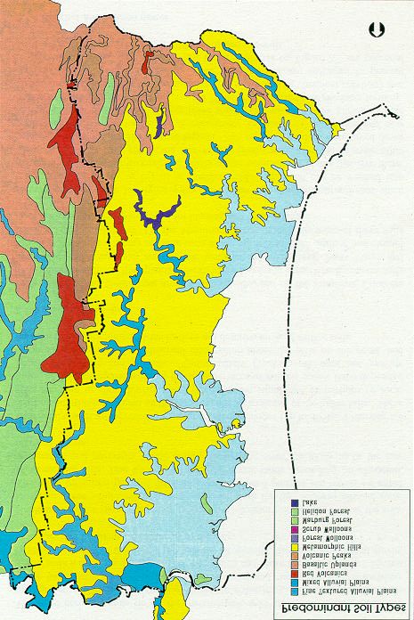
Figure 2.3 presents the land resource information for the Gold Coast from Noble
(1996). Noble describes pockets of highly fertile red volcanic soils (Krasnozems
derived from the basalt of the Tweed volcano) mainly on the elevated plateaux of
Tamborine, Beechmont, and Springbrook.
2-5Chapter 2: Description: GCCC SoER 1997
2-6Chapter 2: Description: GCCC SoER 1997
Figure 2.3: Land resource areas of the City of Gold Coast
(compiled by Forster and Harms in Noble 1996, reproduced with the permission of the
Queensland Department of Natural Resources).
2-7Chapter 2: Description: GCCC SoER 1997
The most common soils lie on the metamorphic hills (Red and Yellow Podzolics mainly
derived from the Neranleigh-Fernvale sediments). These are duplex soils which have
distinct loamy surface-soil (A horizon) and clayey sub-soil (B horizon). These soils
tend to be quite acid (pH 4.5) which can make them less fertile. He has omitted the
sands of the dunes and beaches (Regosols), derived from coastal fluvial processes that
lie along the east coast of the City.
Noble omitted the islands in Moreton Bay from his description of the soils of the area.
However, these would most likely be included with the fine textured alluvial soils. The
more urbanised parts of the City have also been omitted but would be either
Metamorphic hills, fine textured alluvia, or dunal sands depending on elevation,
topography and proximity to the ocean. Low lying areas are likely to be the fine
textured alluvia.
Other soils, such as the red clays, occur on steeper slopes (up to 40%). Lithosols are
shallow infertile soils found on the summits and steep slopes of the lower hills. These
soils tend not to show horizons and often contain significant proportions of rock.
Some of the most fertile soils are the small terraces of Alluvia (creek flats) deposited
beside the Rivers and streams. Unfortunately Franks work does not provide
comprehensive physical or chemical information about the soils on the coast, and
because of his agricultural focus, he does not describe the acid sulfate soils.
2.2.3 Acid sulfate soils
In the north of the Gold Coast around Woongoolba, and on the Pimpama, Coomera
and Merrimac/Carrara floodplains are extensive low-lying areas which contain soils
associated with mangrove and tea-tree wetlands (Humic Gleys, Peaty Gleys and
Meadow Podzolics). Many of these soils in the north have been drained and cleared
for sugar-cane production. On the Merrimac/Carrara floodplain some of these soils
have been subsequently developed for housing and canal estates.
Development of these low-lying soils can expose acid sulphate subsoil that when moist
and exposed to air begins to produce acid. This acid can be washed into surrounding
waterways harming the health of the animals and plants that live there. These acid-
sulfate soils containing iron pyrites (FeS2) were layed down some 6000 years ago when
the sea levels were higher. The areas where they were layed down were then shallow
marine lakes. Subsequently, the sea level has fallen and new sediments have been
deposited over these soils. The subsoils were kept anaerobic (oxygen depleted) by the
high water-table. This prevented the acid products forming. Disturbance of these soils
and exposure to the air results in chemical reactions that produce acid. These acid
products need to be treated and managed to prevent environmental harm. The areas of
fine textured alluvia on Figure 2.3 are potential areas of the Gold Coast with acid
sulfate soils and sub-soils.
2.2.4 Beaches and coastal dunes
The current beaches and dunes of the Gold Coast are a primary asset to the area. They
are important to the quality of life of many residents and form the basis to the tourism,
recreational and leisure industries that exist in the City. The sand that forms the
2-8Chapter 2: Description: GCCC SoER 1997
beaches of the Gold Coast is eroded from the New England Tablelands of Northern
New South Wales.
These sands are then carried north in a longshore current along the coast. This current
carries approximately 500,000 M3, net, along the coast each year to form the sandy
ocean beaches of Northern New South Wales and Southern Queensland.
The beaches and dunes of the Gold Coast have been highly transformed through
clearing and development for both agricultural and particularly urban expansion onto
the fore-dunes. In addition to this, many areas along the Gold Coast have been totally
disturbed through sand mining. These changes, and the construction of groynes which
restrict the northerly flow of sand, have reduced the ability of the beach and dune
system to withstand severe storms often associated with cyclones. Consequently,
beach erosion is a major issue along the Gold Coast which the Council and
Governments from both Queensland and New South Wales seek to address.
2.3 Climate - including rainfall
2.3.1 Rainfall
Average annual rainfall on the Gold Coast varies from around 1500mm on the Coast
and in the northern half of the City to as much as 3000mm in Springbrook. Figure 2.4
represents this information as climate zones and Table 2.1 presents the seasonal spread
of rainfall for four key stations; Southport, Mt Tamborine, Beenleigh, and
Springbrook.
The rainfall varies across the City depending on altitude and latitude. The south of the
City receives more rain than the north as the Springbrook plateau contributes to a rain-
shadow over the rest of the Gold Coast.
Table 2.1: Rainfall summary data for five key stations in the City of Gold Coast
(source: Australian Rainman v2.2 1996)
Station Mean annual Maximum Minimum Average
rainfall annual annual number of
rainfall on rainfall on raindays per
record record year
(mm) (mm) (mm)
Mt. Tamborine 1550 3644 598 131
Southport 1457 2676 584 121
Beenleigh 1189 2398 390 97
Springbrook 3074 5649 1315 147
2.3.2 Temperature and evaporation
The Gold Coast has a number of rainfall stations. However, long-term records of
temperature and evaporation data have only been recorded at three stations, Mt.
Tamborine, Southport and Coolangatta.
Table 2.2 presents climate data of maximum and minimum average monthly
temperatures and the months those temperatures occur, and the maximum daily
2-9Chapter 2: Description: GCCC SoER 1997
evaporation for Mt Tamborine as representative of the hinterland, and Southport as
representative of the Gold Coast.
There are clearly intergrades between these points depending on elevation, aspect and
distance from the Coast. It should be noted that Tamborine has a similar average
annual rainfall to that of Southport.
Table 2.2: Maximum and minimum average monthly temperatures and
evaporation for a hinterland and a coastal location on the Gold Coast
(source: Australian Rainman v2.2 1996)
Location Average Average Maximum daily
maximum minimum evaporation
temperature. temperature. (mm/day, Class A )
(oC) (oC)
Mt. Tamborine 25.6(Dec/Jan) 7.9(Jul) 3.7(Jan)
Southport 28.6(Jan) 9.2(Jul) 4.8(Dec)
Frosts are not frequently observed on the Gold Coast where average winter
temperatures do not get below 6o. Frosts have mainly been observed in and around the
crests and plateaus of the ranges. While severe frosts (< -2.0o on the ground) have not
been recorded by the Meteorological Bureau at Mt. Tamborine although other
hinterland locations may be more affected by frost.
2.3.3 Airshed and circulation with seasonal variations
The Gold Coast is affected, at times, by pollution from Brisbane’s Central Business
District (Boffinger, (1993). However, this is infrequent and restricted to the
Coombabah area. Most effects on air quality are believed to be minor and local in
origin.
This is mainly due to the fact that the Gold Coast enjoys the favour of daily cycles of
wind movement due to the difference in temperature of the land and the sea.
However, there are also seasonal variations on the wind direction. This influences
combine to give predominant wind directions in the morning and afternoon in summer
and winter. These are shown in Table 2.2.
Table 2.2: Dominant wind direction for the Gold Coast
Summer Winter
Morning S to SE S to SW
Afternoon NE to SE SE to W
2.4 Water
2.4.1 Groundwater
2-10Chapter 2: Description: GCCC SoER 1997
The ground water resources of the Gold Coast were identified to be of non-
commercial quantity by the Water Resources Commission of Queensland in 1979 and
are limited to the dunal coastal areas where a small lens of freshwater overlies the
denser salt water. This lens, or aquifer, is fed by rainfall. Groundwater in the coastal
areas would supply low yields of good quality water and would be subject to
contamination from salt water if withdrawals were excessive.
Council has not conducted regular monitoring of the quality of the groundwater and it
has never been recommended for drinking. However, the aquifer has been accessed by
spear pumps for irrigation purposes. Evidence of iron staining on driveways and
fences suggests the groundwater contains high levels of iron. Additionally, sulphide
odours (eg. rotten egg gas) are apparent when using the water.
2.4.2 Streamflow
Streamflow in the Gold Coast changes considerably with the seasons and is typical of a
subtropical environment. Most rainfall occurs in the spring and summer months, and
much of this in storms. This contrasts with the relatively dry winter months.
Consequently, most streamflow occurs in the Spring and Summer, and many minor
tributaries and streams are ephemeral and only flow during periods of high rainfall.
Environmental flow is that component of streamflow that is required to sustain the
ecosystems of the waterway.
2.5 Ecosystem diversity, vegetation cover and species diversity
2.5.1 Ecosystem diversity
The environment of the Gold Coast consists of a wide range of landscapes, habitats,
climates and land-uses, ranging from the coastal dunes, mangroves and waterways,
through to the canelands in the north, the mountains and rainforests in the west, and
the highly urban areas in the south-east. Southeast Queensland and Northeast New
South Wales have a high diversity of landscape forms and habitat which contribute to
the regions high diversity of native plants and animals. This high level of biodiversity
has been compared to that of Queensland’s Northern Wet-tropics (Catteral and
Kingston 1993 p.3) and recently with Kakadu in the Northern Territory (M. Kingston,
Ecograph pers. com.). The reasons for this diversity begins with the formations of the
land itself, its geomorphology and its soils, as discussed earlier.
The soils, in conjunction with the climate, support different communities of plants. It
is known that the Gold Coast land area was once completely covered with forest and
bushland, ranging from coastal wallum (heaths), to mangrove, to open eucalypt
woodlands to rainforest. However, through the process of European settlement of the
land much of the original vegetation cover of the area has been cleared. Early
estimates put the area of remnant bush at 40% (Catteral and Kingston 1993).
However, more recent detailed studies have identified approximately 50% of the total
City as being covered by remnant bush (M. Maher and associates et al. 1997).
2-11Chapter 2: Description: GCCC SoER 1997
The Gold Coast has a diversity of soil types and terrain that provides a number of
subtropical ecosystems. These range from marine and estuarine to fresh water
ecosystems, and from coastal heaths (wallum) to open forest, to closed forest to
rainforest. In addition to these natural ecosystems there exists a number of human land
uses such as grazing, agriculture, forestry and various forms of urban development that
provide a wider range of ecosystems
This wide diversity of ecosystems in a single region presents a unique combination that
supports the high species diversity evident in the City of Gold Coast.
2.5.2 Vegetation cover
Some 50% of the Gold Coast remains under remnant vegetation. The other 50% has
been cleared for agricultural and urban development over the past 170 years, with most
clearing taking place before the middle of this century. For example, the then land
owner, Gooding, cleared Clear Island, which was once a wooded hill in the Clear
Island Waters area, in 1915. Since that time significant amounts of natural regrowth
has occurred as well as revegetation in urban and rural areas. Current estimates of
remnant and regrowth natural bush cover of the Gold Coast approach 52% of the total
area.
Despite the level of clearing that has taken place on the Gold Coast, the area still
contains a higher proportion of Southeast Queensland’s remnant bush (7.6% - Catteral
and Kingston 1993) than any other local authority in the region.
This is due to the lower level of broadacre agricultural development that took place on
the Gold Coast, the mountainous hinterland, and the recognition of the importance of
the areas natural environments. This bushland has often been referred to as the ‘green
behind the gold’ and has been a primary asset for the areas of tourism and recreation
since the late 1800s. However, most remnant bush (66% - M. Maher and Associates
et al.) is held as private land and is not specifically protected as it is in reserves and
National Parks.
With the exception of an area behind the Coolangatta Airport, Pine Ridge
Conservation Park and South Stradbroke Island itself, little to no coastal heath remains
on the Gold Coast. Considerable areas of mangrove exist in the north of the region
with remnant communities along parts of the tidal sections of the rivers and creeks.
Significant areas of open forest remain on the rolling hills between the coastal plain and
the steeper sections of the mountains. Most of the areas of rainforest that remain are
restricted to the National Parks. Interestingly, Antarctic Beech survive on the peaks
around Springbrook. These trees are related to the beech trees that once existed in
large forests in Antarctica when it, and Australia were a part of Gondwanaland.
This situation provides the City of Gold Coast with a tremendous opportunity for
further developing and enhancing our unique lifestyle. It also places a great
responsibility on the people of the Gold Coast to understand and manage the
development of this resource.
2-12Chapter 2: Description: GCCC SoER 1997
2.5.3 Estuarine and marine systems
The entire drainage of the Gold Coast enters the ocean via its rivers and streams. With
the exception of the Tallebudgera, Currumbin and Coolangatta Creeks, which enter the
ocean directly, all other rivers and streams enter the Broadwater and Southern
Moreton Bay before entering the ocean. All of the rivers and streams form tidal
estuaries in their lower reaches. Salt water crocodiles were native to the area with one
being caught in the Nerang River as late as 1890 (Jones 1988).
The Tallebudgera creek estuary forms the Southern Boundary for the Burleigh Heads
National Park.
Southern Moreton Bay, including the Broadwater, is part of the Moreton Bay Marine
Park which was declared a marine park by the State Government in 1993. Within the
marine park there a number of Ramsar sites. These sites are recognised internationally
as significant wetland areas by a convention signed in Ramsar in 1971. Ramsar is a City
in Iran from which the convention took its name.
Coombabah Lake and its surrounding lands have long been recognised for their
environmental importance, containing diverse habitats that range from open water, to
saltmarsh, to mangrove. The tidal waters of the lake are recognised as a fish sanctuary
under the Fisheries Act.
There are some 53km of ocean beaches along the eastern edge of the Gold Coast
including South Stradbroke Island. These beaches and the surrounding marine
environment are a major natural asset of the coast and underpin much of the tourism
industry. While officially the beach below high tide and the offshore reefs fall outside
the Council’s boundary, they are a natural asset to the area and sustain a considerable
range of marine species. Approximately 1600 different marine species have been
identified in the waters off the Gold Coast (CFA Fisheries Research Foundation,
1996).
2.5.4 Species diversity
The Gold Coast has been identified as one Australia’s most species-diverse regions in
Australia, with more species than even Kakadu (M. Maher and Assoc. et al. 1997).
This was discovered by consultants engaged to develop a nature conservation strategy
for the Council. There are over 1550 identified species of native plant, over 323
species of bird, over 105 species of reptiles and amphibians and over 72 species of
mammal.
In the past the area south of the Nerang River, the Merrimac/Carrara floodplain, was a
large swamp with a number of ‘islands’. This was a diverse wetland environment of
tea-tree, sedges, heaths, ferns and vines, wallum banksia, she-oaks, some open forests
and many areas of deep open water. This was a key area to the local aboriginal people
and home to many animal species including the black swan. Remnants of these
wetlands still exist in the floodplain. Black Swans can still be found around Carrara.
2.6 Socio-economic
2-13Chapter 2: Description: GCCC SoER 1997
2.6.1 Heritage listed sites, structures and landscapes
The lands and the landscape of the Gold Coast area are considered of heritage and
cultural value to all residents. Within this landscape were many significant sites of
Aboriginal cultural heritage. Today, due to past developments and practices only some
sites remain, such as the Bora Ring at Burleigh Heads and the middens on South
Stradbroke Island, and those around the Broadwater and Southern Moreton Bay.
While the Europeans have only been on the Gold Coast in comparatively recent times
and many of the original buildings of the coast have been replaced, there are 11
buildings and 12 sites which are listed by either the National Trust or on the State
Heritage Register as having heritage value. The buildings range from churches such as
the Lutheran Church at Bethania (1872) to the Southport Drill Hall (1890) and the
Pacific Cable Station (1902), which has since been relocated to The Southport School,
through to the Pimpama and Ormeau War Memorial (1919) and to Kinkabool (1959)
the first high-rise holiday apartment on the Gold Coast. Many National Parks,
Conservation Parks and Reserves, and one Ramsar site are included in this list, as well
as all known sites of Aboriginal heritage.
2.6.2 Environmental impacts on people
The environment of the Gold Coast is a positive part of the lives of people everyday.
However, it can have negative impacts in many ways.
Catastrophic impacts, such as cyclones, flooding, bushfire and drought, are largely
beyond the control of Council to mitigate. We can only reduce the impacts of these
events when they occur through urban planning, building design and construction and
infrastructure development. The impacts of these phenomena are only too easily
observed on the beaches, along the river, and in the hinterland. The community,
including Council, bears much of the cost of repairing the damage.
Less obvious environmental impacts on the City are a direct result of human activities
in the ecosystem, coupled with the City’s proximity to those ecosystems. For example,
mosquitoes have long been associated with the Gold Coast. Much of this association
is due to the fact that significant areas of the Gold Coast are adjacent to the
mosquitoes’ habitat. A second example is provided by the biting midge which causes
problems to residents along some waterways. The biology of this species has yet to be
fully explored but it is suspected that the materials used in the construction of the
beaches in the canals can influence the numbers of this pest (R. Williams, Gold Coast
City Council, pers. com. 1997).
2.6.3 Perceptions of people on the environment
There is no data specific to the City of Gold Coast. However, it is reasonable to
assume that the population of the City holds similar views to that of Australians in
general. The following information is based on Australian Bureau of Statistics data
(ABS 1996):
2-14Chapter 2: Description: GCCC SoER 1997
• 70% of people consider environmental protection to be as important as economic
growth. This figure has remained static since 1972.
• Since 1992 the number of people concerned about the environment has declined
from 75% to 68% (1996).
• Most people concerned with the environment were between 35 and 44 years of
age, or were women (except for pollution and land degradation), professionals,
high income earners, and people with tertiary qualifications.
• Air pollution was seen as the single most important environmental issue (31% of
respondents).
• Only 23% of the people surveyed believed that the quality of the environment had
improved over the last ten years. 44% believed that it had declined.
2.6.4 Social
The Gold Coast has been described as a sunbelt city that has developed and grown due
to net migration from other areas of Australia, in particular Sydney, New South Wales
and Melbourne, Victoria. A significant proportion of migrants are retirees but in
recent times there has been an increase in business and tradespeople moving from other
parts of Australia to escape economic downturns. The attraction of the coast as a
home for many people is its lifestyle, its proximity to a State Capital, its services and its
growth rate.
The rapid development of the Gold Coast has led to some recent suburban areas
suffering social isolation and a lack of public facilities and transport.
2.6.5 Current population and demographic features
The population of the Gold Coast is approximately 356,571 people (June 1996), with
49% male and 51% female. The population is growing at around 15,000 people
(4.8%) a year which is equivalent to the Gold Coast growing by a new city the size of
Warwick, Queensland each year. These people will require between 17,000 and
24,000 new dwellings from 1995 to the year 2000. Some 65% of these new dwellings
will be separate houses (Taylor 1996).
Like the population of Australia as a whole, the population of the Gold Coast is aging.
For example, in 1991 there were 14% of the Gold Coast’s people over the age of 65.
This compares to 11% of the population over 65 for either Queensland or Australia.
This age group is expected to represent between 20.5% and 22% of the population by
the year 2041 (Taylor 1996). Some 89% of the Gold Coast’s population live in urban
areas (A. Taylor, GCCC Demographer pers. com.).
The number of single parent families on the Gold Coast has increased by 86% since
1986. Gold Coast households have become smaller with nearly half (49%) comprised
of either one person or a couple with no children. More than 55% of households
averaged 2.2 people, or less (Taylor 1996).
Some 1600 Gold Coast residents (0.45% of the population) are of Aboriginal and
Torres Strait Islander decent. About 25% of Gold Coast Residents were born
overseas with approximately 9% from non-English speaking countries.
2-15Chapter 2: Description: GCCC SoER 1997
2.6.6 Economic
It is difficult to estimate the total size of the Gold Coast’s economy and a definitive
figure for the gross regional product (GRP) of the Gold Coast has yet to be achieved.
However, in the last few years researchers have estimated a Gross Regional Product at
$4,446 million (Raybold 1996) and the size of a number of sectors of the Gold Coast’s
economy; tourism - $1,614 million (Raybold 1996), education - $320 million (Mula
1995), and $308 million for the community services sector excluding parks and
gardens, sport facilities, waste management and environmental protection ($5m/$72m
94/95) (Mules 1997).
2.6.7 Industry structure (number of enterprises/type)
There are 17 different types of enterprise on the Gold Coast. Table 2.2 shows the total
number per category for the City. Most enterprises on the Gold Coast are in
manufacturing, construction, wholesale and retail trade and financial, insurance and
property and business services. However, of the rest, only mining, electricity and gas,
communication and government represent small numbers of enterprises.
2.6.8 Employment by sector
In 1991, the total labour force of the Gold Coast was 136,556 (56% full-time, 25%
part-time, 5% not stated, and 14% unemployed).
Most employees on the Gold Coast (73%) are employed in six main industries,
wholesale and retail (21.47%), finance, insurance and property and business services
(13.02%), personal and other services (10.31), manufacturing (10.08%), construction
(9.95%) and accommodation (8.36%). People employed in the tourist industry are not
recorded in a single category but are distributed across many. However, the Gold
Coast has a higher proportion of people employed in the construction, wholesale and
retail, insurance, finance, and property and business services sectors than both
Queensland or Australia in every case.
Fewer people on the Gold Coast were employed in community services than for either
Queensland or Australia. There is a higher proportion of unemployed people on the
Gold Coast than for Queensland or Australia
2-16Chapter 2: Description: GCCC SoER 1997
Table 2.3 Number and type of enterprises on the Gold Coast
(source : GCCC Ec. Dev. Branch 1996)
Enterprise type Number of Percentage of
enterprises employed
people in
1991
Agriculture, Forestry and Fishing 465 1.25
Mining 58 0.28
Manufacturing 4496 10.08
Electricity, Gas and Water 27 0.42
Construction 2977 9.95
Wholesale and Retail Trade 4517 21.47
Accommodation, Cafes and Restaurants 939 8.36
Transportation and Storage 735 3.92
Communication Services 60 1.22
Financial, Insurance and Property and 4176 15.84
Business Services
Government Administration and Defence 46 2.84
Education 256 4.92
Health and Community Services 1124 8.03
Cultural and Recreational Services 467 3.97
Personal and other Services 769 10.31
TOTAL 17812 100.00
2.6.9 Income
In 1991, there was a larger proportion of residents earning less than $12,000 than in
Queensland or Australia. In addition, there was a smaller proportion of residents
earning above $30,000. Family incomes reflect these data. More families on the Gold
Coast earn less than $12,000 than for Queensland or Australia, and fewer families earn
more than $40,000 than for Queensland or Australia.
2.6.10 Council expenditure on the environment
The total budget of the Council for 1995/96 was approximately $375,500,000. This
represents an expenditure of around $1100 per resident. The Council employs around
2300 staff.
The Gold Coast City Council spends at least 70% of its budget on environmentally
related activities. This was identified through an Australian Bureau of Statistics trial
survey. The main components of this expenditure are in provision of clean drinking
water, and in waste and sewerage services to the community. Fewer amounts were
spent on environmental protection and/or repair of environmental damage. Planning of
the development of the City is also included as a key area associated with maintaining
and protecting the environment. Only around 1% of the Council’s budget is spent on
protecting and enhancing the natural environment.
2-17Chapter 2: Description: GCCC SoER 1997
2.7 References
Australian Bureau of Statistics (1996) Environmental issues: people’s views and
practices, Australian Bureau of Statistics, Catalogue No. 4602.0
Beckmann, G.G. (1967), Soils and Land Use in the Beenleigh-Brisbane area, South-
eastern Queensland, Soils and Land Use Series No. 50, Division of Soils.
Commonwealth Scientific and Industrial Research Organisation.
Beckmann, G.G. and Reeve, R. (1972), Classification and Chemical Features of
Soils of the Beenleigh-Brisbane Area, South-East Queensland, Division of
Soils Technical paper No. 11, Commonwealth Scientific and Industrial
Research Organisation
Boffinger, N. (1993) Brisbane Air Quality Strategy Phase One. Report to the Brisbane
City Council
Catterall, C.P. and Kingston, M. (1993) Remnant Bushland of Southeast Queensland
in the 1990s: its distribution, loss, ecological consequences and future
prospects., Institute of Applied Environmental Research, Griffith University.
Forster, B.A. (1989) Availability of suitable land for sugar-cane growing: Rocky
Point sugar mill area., Land Resources Branch, Queensland Department of
Primary Industries.
Franks, H.D. (1971), A review of land use and Development in South Coastal
Queensland., Division of land Utilisation, Technical Bulletin No.2. Queensland
Department of Primary Industries.
Holz, G.K. (1979), Rocky Point: A sugar cane land suitability study, Division of Land
Utilization, Technical Bulletin No.38, Queensland Department of Primary
Industries.
Jones, M. (1988) Country of Five Rivers: Albert Shire 1788-1988, Albert Shire
Council, Allen and Unwin.
M. Maher and Assoc. and Ecograph (1997) Nature Conservation Strategy for the City
of Gold Coast Vol 1., Gold Coast City Council.
Mula, J (1995) Education in Paradise, Gold Coast Regional Strategy Forum Inc
Mules, T. (1997) Economic Significance of the Community Services Sector. School of
Accounting and Finance, Griffith University
Noble, K.E. (1996) Understanding and managing soils in the Moreton Region,
Queensland Department of primary Industries
Raybold, M (1996) Input Output methods in Tourism Analysis and planning in the
Gold Coast City, Master of Regional Science Thesis, University of Queensland
2-18Chapter 2: Description: GCCC SoER 1997
Taylor, A. (1996) Population Growth Dynamics, Social Studies, Gold Coast City
Council Research Unit.
Wilmott, W.F. (1986) Rocks and Landscapes of the Gold Coast Hinterland,
Geological Society of Australia Inc.
2-19You can also read