The Geography Curriculum - September 2021 - Lincoln Carlton Academy
←
→
Page content transcription
If your browser does not render page correctly, please read the page content below
The Geography
  Curriculum
   September 2021
The Geography Curriculum at Lincoln Carlton Academy has been designed to encourage our pupils to be curious about the world they live in and understand their
                 place within it. It gives them opportunities to ask questions and develop the knowledge and skills they need to be independent thinkers. Our aim is to equip our pupils
                 with knowledge of the diverse places, people, resources, natural and human environments of the world, together with a deep understanding of the earth’s key
                 physical processes. Our local area provides a wealth of opportunities for children to go out an investigate their immediate environment and our curriculum has been
Intent

                 designed to embrace these opportunities as often as possible.

                 The curriculum is centred around 4 key geographical concepts: locational knowledge, investigating places, natural processes and geographical skills. These concepts
                 are first encountered in the Early Years Foundation Stage and are revisited in every key stage. These regular revisits ensure that children will know more, remember
                 more and develop a deeper understanding of the key concepts during their time at LCA. It will also support them to develop connections between their prior
                 knowledge and new learning. Now, more than at any time in the history of our planet, it is vital that our children know the impact that humans are having on the
                 natural resources and physical features of the world around them and how this could impact on their future.
Implementation

                 The curriculum at LCA is blocked into topics which provides an overarching theme for learning. Where possible, geography themes are interleaved into these topics to
                 support children to make links to other areas of the curriculum. Teachers use the long term overview for geography along with corresponding knowledge organisers
                 to plan sequences of lessons. These lessons are designed to revisit key concepts and knowledge and teach new vocabulary, alongside introducing new knowledge. At
                 LCA there is no requirement for teachers to plan lessons in a particular style or deliver them in a specific format. We encourage teachers to be innovative and creative
                 in their approach and to use strategies that they know will meet the needs of the pupils in their class.

                 Our pupils will:

                 •   Be analytical thinkers who can use maps, globes, atlases and digital mapping applications to locate continents, oceans, countries and other physical features of
Impact

                     our planet.
                 •   Have excellent knowledge of the human and physical features of a range of places around the world as well as some of the key natural processes that occur on
                     Earth. This will ensure they are prepared for the next stage in their geography education.
                 •   Make their own decisions about how they will communicate their ideas and explanations.
                 •   Embrace challenging activities, including opportunities to undertake geographical fieldwork in a range of different environments.
                 •   Talk knowledgably about the impact that humans continue to have on our planet and its natural processes and have the ability to debate and discuss these issues.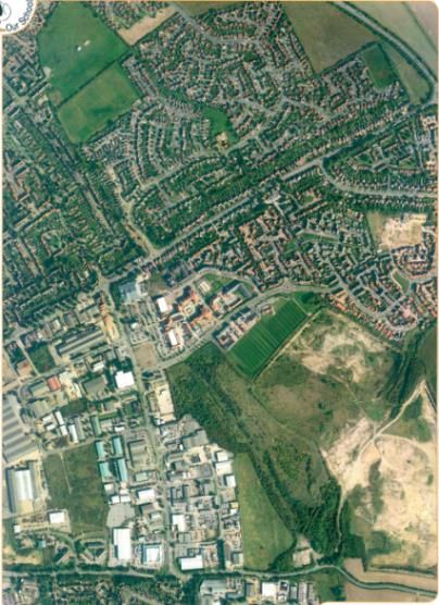
Year 1 – Autumn 1                                                                                                                   Key Concepts
Theme: Paws,                   Cross-Curricular Links
                               Mathematics – Position and direction – points of the compass
claws and whiskers
Key Vocabulary                 Prior Learning                                                      Next Steps
Continent, ocean, country,     EYFS – Children learn about their house, their street and some of   Year 1 – Human and physical features of Lincoln using maps.
North Pole, South Pole,        the features of the local environment.                              Creating simple maps
Equator                                                                                            Year 2 – The countries and capital cities of the UK
                                                                                                   Year 3 – UK counties
Key Assessment Questions
Can you name the seven continents of the world? Can you label them on a map?
Can you name the five main oceans of the world? Can you label them on a map?
Where are the hottest places of the world located?
Knowledge to be taught
There are 7 continents of the      There are 5 main oceans in the World:
world:                                 • Atlantic Ocean (between the Americas and Europe and Africa)
   • Europe (where the UK              • Pacific Ocean (between the Americas and Asia and Australasia)
        is located)                        – The largest ocean in the World
   • Asia (the largest                 • Indian Ocean (south of Asia)
        continent)                     • Arctic Ocean (Most northern Ocean)
   • North America                     • Southern Ocean (Most Southern Ocean)
   • South America
   • Africa
   • Antarctica
   • Australasia (smallest
        continent)
   • The hottest countries in the World are located on the Equator (Brazil, Uganda, Kenya).
   • The coldest countries in the World are located at the North and South Poles (southern Argentina,
        South Africa in the South, Northern Canada and Northern Russia in the North).
   • Antarctica is almost completely covered by ice for most of the year.

Definitions
Continent – A large mass of land made of many countries.
Country – A nation with its own government, occupying a particular territory.
Equator – An imaginary line drawn around the middle of the Earth (at its widest point).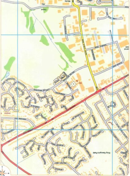
Year 1 – Autumn 2                                                                                                                                    Key Concepts
    Theme: Towers, tunnels                    Cross-Curricular Links
                                              History – Roman Lincoln, The Norman Castle and Cathedral
    and turrets                               Maths – Positional language and direction

    Key Vocabulary                            Prior Learning                                                                                Next Steps
    Physical, human, feature, city, town,     EYFS – Children learn about their house, their street and some of the features of the local   Year 2 – Rajasthan and Lincoln: Skegness and
    village, factory, farm, house, office,    environment.                                                                                  Scarborough
    shop, forest/wood, quarry, farm, river,   Year 1 – Locating continents and oceans of the world                                          Year 3 – UK counties
    vegetation, castle                                                                                                                      Year 5 – Skegness and Scarborough
                                                                                                                                            Year 6 – London and New York
    Key Assessment Questions
    What is the difference between a human feature and a physical feature?
    Can you give an example of a human feature and an example of a physical feature?
    Knowledge to be taught
    A human feature of a geographical area is one that has been put there or made by humans.
    A physical feature of a geographical area is one that occurs naturally.
    On aerial photographs and maps to locate the following human and physical features of our local area:
o   Human:
              o Roads
              o Houses
              o Post Office
              o Factories
              o Quarry
    Physical:
              o Woodland
              o Grassland
              o Rivers/streams
•   Create a simple map of our school to include symbols and a key:
              o Hall
              o Learning Street
              o Classrooms
              o Offices
              o Playground
              o Field
              o Cage
    Definitions
    Physical feature – The natural features of the Earth’s surface.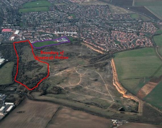
Human feature – Modifications that human beings have made to the land.
Year 1 – Summer 1 Key Concepts
Theme: The Cross-Curricular Links
Science – Seasonal changes, making observations, gathering data
Enchanted Woodland Maths – Statistics, gathering data
Key Vocabulary Prior Learning Next Steps
Climate, regional, pattern, EYFS – Observing the weather through daily welcome activity. Exploring the weather Year 4 – Flooding and coastal erosion
weather, cold, coldest, warm, when in the outdoor area. Year 4 – 6 – Climate zones and biomes of the
warmest, hot, hottest, dry, world
driest, wet, wettest, season,
seasonal
Key Assessment Questions How could knowledge acquisition be assessed?
Which season is the coldest and the wettest?
Which season is the hottest and the driest?
Knowledge to be taught (Gateway knowledge in red)
• Winter in the UK – Coldest and wettest season of the year
• Summer – Hottest and driest season of the year
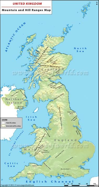
• The coldest places in the UK are at the highest levels above sea level:
o The Highlands - Scotland
o The Pennines - England
o Snowdonia - Wales Annual
• The wettest places in the UK are in Western areas: Rainfall Map
o The Lake District – England
o Snowdonia – Wales
o Western Highlands - Scotland
• The warmest places in the UK are in Southern England:
o The Isles od Scilly
o Cornwall
• The driest places in the UK are in South Eastern England:
o Essex
o East Anglia
Definitions
Climate – The weather conditions in an area over a period of time.
Regional – Relating to a specific place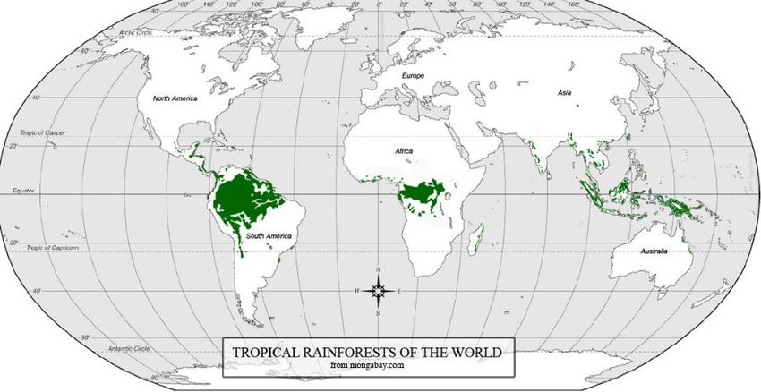
Year 2 – Autumn 2                                                                                                                                         Key Concepts
                                                         Cross-Curricular Links
Topic: Bright Lights, Big City                           History – Places of historical significance in the local area and nationally. Maths – Position
                                                         and direction – 4 compass points

Key Vocabulary                                                           Prior Learning                                              Next Steps
Hot, Cold, Weather, Pattern, North, South, East, West, United Kingdom,   EYFS – Children learn about their house, their street       Year 1 – Locating continents and oceans of the world
England, Scotland, Wales, Northern Ireland, map, atlas, globe,           and some of the features of the local environment.          Year 2 – Human and physical features of Lincoln using
parliament, building, castle, government, governed, city, capital city   Year 1 – Human and physical features of Lincoln             maps. Creating simple maps
                                                                                                                                     Year 3 – UK counties

Key Assessment Questions
Can you name the 4 countries of the United Kingdom?
Can you name the capital city of each country in the United Kingdom?
Can you locate Lincoln on a map of the United Kingdom?
Can you point out some of the human and physical features of Lincoln on an aerial photograph?
Knowledge to be taught
•   The United Kingdom is closer to the North Pole than the South Pole.
•   There are four countries that make up the United Kingdom – England, Scotland, Wales and Northern Ireland.
•   Each of the countries has a capital city:
        o Edinburgh – Edinburgh Castle, Holyrood Palace (Devolved Government meets here)
        o London – Big Ben, Houses of Parliament (Government meets here), Buckingham Palace, 10 Downing
             Street
        o Belfast – Stormont Parliament Buildings (Devolved Government meets here), Shipyards (where Titanic
             was built)
        o Cardiff - Cardiff Castle, Millennium Stadium, Welsh Assembly Building (Devolved Government meets
             here).
•   Locate Lincoln on a map of the United Kingdom. Establish that Lincoln is a city.
•   Use aerial photographs and maps to locate key physical and human features in Lincoln:
        o Lincoln Cathedral
        o Lincoln Castle
        o Brayford Pool
        o River Witham
        o Lincoln Central Railway Station
        o Bus Station
Definitions
Capital City – A city from where Governments run a country.
Government – A group of people with the authority to govern a country.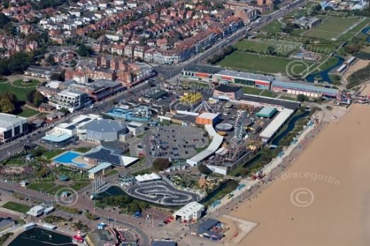
Parliament – The Queen, The House of Commons and the House of Lords.
Year 2 – Spring 1                                                                                                                     Key Concepts
Theme: Food, Glorious Food                        Cross-Curricular Links
                                                  RE – Religions of the world
                                                  Design and Technology – Food Technology

Key Vocabulary                                    Prior Learning                                                          Next Steps
India, Asia, Lincoln United Kingdom,              EYFS – Children learn about their house, their street and some of the   Year 3 – UK counties
continent, country, rural, city, desert,          features of the local environment.                                      Years 4 – 6 – Locating various countries in
houses, roads, shops, factories, woodland,        Year 1 – Locating continents and oceans of the world                    Africa, north/South America, Asia
deciduous, grassland, river, stream               Year 2 – The countries and capital cities of the UK

Key Assessment Questions
Can you locate India on a map of the World?
Can you give an example of a human and a physical feature of Rajasthan, India?
Knowledge to be taught (Gateway knowledge in red)
Human and physical features will differ in different areas of the world.
    • Locate India on a globe and on a map.
    • Locate Rajasthan, North West India on a map.
    • Most of Rajasthan is made up of the Thar Desert.
    • Share the story of a child who lives in the desert region of Rajasthan:
https://www.bbc.co.uk/programmes/p0115c7k
Compare the human and physical features of Rajasthan and Lincoln:
                                        Lincoln – A city                        Rajasthan – Rural village
 Human Features                         Lincoln Cathedral                       Straw and mud huts
                                        Lincoln Castle                          Agricultural land (fields)
                                        Houses                                  Quarry
                                        Shops
                                        Factories
                                        Roads
 Physical Features                      Deciduous Woodland                      Scrub Forest
                                        Grassland                               Desert
                                        Rivers/streams                          Salt Water Lakes
Definitions
Rural – Relating to the countryside rather than the town.
Urban – Relating to the town or city
Deciduous – A tree that sheds its leaves every year.
River – A channel of water that flows to the sea.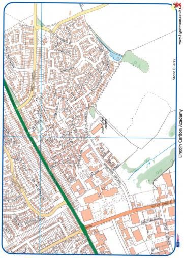
Stream – A small, narrow river.
Year 2 – Summer 2                                                                                                                   Key Concepts
Theme:                                    Cross-Curricular Links
                                          Maths – Position and direction – points of the compass
Beachcombers
Key Vocabulary                            Prior Learning                                                              Next Steps
Seaside, coast, beach, sea, sand dunes,   Year 1 – Locate features of Lincoln on an aerial photograph                 Year 5 – Local geography field study
promenade, sea defences, salt             Year 2 – Compare the human and physical features of Lincoln and Rajasthan
marshes, pier, fair

Key Assessment Questions
How do the physical features of Skegness differ from the physical features of Scarborough?
Can you describe the similarities and differences between the human features of Skegness and Scarborough?

Knowledge to be taught
•   Locate Skegness on a map of the United Kingdom.
•   Compare the human and physical features of Skegness.
  Human Features                                                   Physical Features
  •  Pier                                                          •    Beach
  •  Caravan Parks                                                 •    Sea
  •  Fun Fair                                                      •    Sand dunes
  •  McDonalds                                                     •    Salt Marshes
  •  Clock Tower
  •  Golf Course
  •  Natureland
  •  Sea defences - concrete
•   Locate North Yorkshire and Scarborough on a map of the United Kingdom
•   Compare the human and physical feature of Skegness and Scarborough
  Human Features - Scarborough                                     Physical Features - Scarborough
  •  Harbour                                                       •    Cliffs
  •  Shops                                                         •    Headland
  •  Promenade                                                     •    Beach
  •  Amusement Arcades                                             •    Sea
  •  Hotels                                                        •    Sand dunes
  •  Scarborough Castle                                            •    Shells
  •  Ferris Wheel                                                  •    Seaweed
  •  Victorian cliff lift

Definitions
Sea Defence – Measures aimed at protecting low lying land from the effects of the sea.
Headland – A narrow piece of land that projects from the coastline into the sea.
Promenade – A paved walkway along the sea front.
Salt Marshes – Coastal wetlands that are flooded and drained by salty sea water.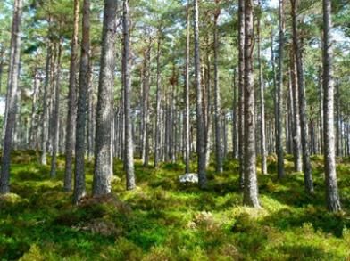
Year 3 – Autumn 1                                                                                                                     Key Concepts
Theme: Extreme                     Cross-Curricular Links
                                   Science – Rock types – Igneous, sedimentary and metamorphic
Earth                              History – The eruption of Mount Vesuvius in AD79.

Key Vocabulary                                                                Prior Learning                                Next Steps
volcano, earthquake, crust, mantle, outer core, inner core, tectonic plate,   Year 1 – Locating and naming the continents   Year 3 – Rocks and formation of igneous,
lava, crater, vent, magma, ash cloud, magma chamber, epicentre,               and oceans of the world (linked to tectonic   sedimentary and metamorphic rocks
aftershock, magnitude, tremor, tsunami, collide, continents, Richter Scale    plates).

Key Assessment Questions
Can you name some of the most famous volcanoes in the World?
Can you describe the structure of the earth?
Can you describe how a volcano erupts?
Can you describe how and why earthquakes happen?
Knowledge to be taught
•   Name and locate some of the major volcanoes of the World:
    o Mount Vesuvius, Italy
    o Mount Etna, Italy
    o Mount St Helens, United States of America
    o Krakatoa, Indonesia
    o Mount Fiji, Japan
    o Cotopaxi, Equador
•   Label the structure of the Earth: Crust, mantle, outer core, inner core.
•   Describe and understand the concept of tectonic plates.
•   Describe how and why earthquakes happen.
•   Refer to the Richter scale as a way to measure the power of an earthquake.
•   Understand the structure of a volcano.
•   Understand how and why volcanoes erupt.
Definitions
https://www.3dgeography.co.uk/volcanic-words
https://www.3dgeography-pictures.co.uk/earthquake-words
Year 3 – Spring 2 Key Concepts
Theme: Urban Cross-Curricular Links
History – How has land use changed in the UK for the industrial revolution?
Pioneers
Key Vocabulary Prior Learning Next Steps
Country, county, city, town, EYFS – Children learn about their house, their street and some of the features of the Years 4 – 6 – Locating various countries in
urban, rural, farming, arable, local environment. Africa, north/South America, Asia
commercial centre, river, Year 1 – Locating continents and oceans of the world Year 6 – How has land use changed during
mountain, land use Year 2 – The countries and capital cities of the UK the last century?
Key Assessment Questions
Can you locate the county of Lincolnshire on a map of the United Kingdom?
Can you name some of the counties that border Lincolnshire?
Can you name and locate some of the major rivers and mountain ranges of the UK?
Can you describe the main industries found in some UK cities?
Knowledge to be taught
• England is divided into smaller areas called counties. Lincoln is in the county of Lincolnshire. Locate Lincolnshire
on a map/digital map.
• Locate some other counties in the United Kingdom – Norfolk, Nottinghamshire, Cambridgeshire, Leicestershire
• Name and locate the main mountain ranges in England: The Pennines, The Lake District, The Peak District, and
The Cotswolds.
• Name and locate the major rivers of England: Trent, Thames, Avon, Ouse.
• Locate major English cities and describe land use in the past and now:
o Manchester – Cotton trade – Mills
o Liverpool – Port and shipbuilding
o Birmingham – Car manufacturing
o Bristol – Port and shipbuilding
o Leeds – Cloth Industry
• Describe the position of each these cities using the 8-point compass.
• Compare urban and rural parts of Lincolnshire:
o Lincoln – Commercial centre – shops, university, factories, leisure facilities
o Southern Lincolnshire – farmland, farm buildings, food manufacturers
• OS Maps
Definitions
Urban – Relating to a town or city
Rural – Relating to the countryside rather than a town.
Commercial Centre – An area of a city with shops, factoriesYear 3 – Summer 1 Key Concepts
Theme: Under the Cross-Curricular Links
Science – Plants and animals and their habitats.
Canopy
Key Vocabulary Prior Learning Next Steps
Biome, aquatic, desert, forest, Year 1 – The Equator, the North Pole and the South Pole Year 4 – The temperate biome
grassland, rainforest, tundra, latitude, Year 2 – Plants and their habitats Year 5 – The desert biome
longitude, hemisphere, Tropic of Year 6 – Darwin’s voyage and biodiversity
Cancer, Tropic of Capricorn,
biodiversity, climate
Key Assessment Questions
Can you name the six main biomes?
Can you locate the Tropics, lines of latitude and longitude?
Can you describe the key features of the tropical rainforest biome?
Knowledge to be taught
Identify the position and significance of latitude, longitude, Equator, Northern Hemisphere, Southern Hemisphere, the Tropics of Cancer and Capricorn, Arctic and Antarctic Circle.
Aquatic Desert Forest
The largest biome. An extremely dry biome. Wide variety of plants and animals.
Covers 75% of the planet. Covers 20% of the planet. Cover about 30% of the Earth’s land area.
Two categories: freshwater and saltwater Depending on their location they can be either hot or cold.
Grassland Rainforest Tundra
Made up of grass varieties and very few trees. Found in regions that are warm all year round (Between the The coldest biome.
Two categories: Short grass (dry) and tall grass (hot and humid). equator and the Tropic of Capricorn). Little plant or animal variety.
Very popular for farming due to rich soils. Now only covers about 6% of the planet. Covers 20% of the planet.
Tropical rainforests of the World (tropical rainforest biome)• Amazon, Brazil, South America
• Congo, Africa
• South East Asian
There are 4 main characteristics of the tropical rainforest biome:
• Very high annual rainfall
• High average temperatures
• Nutrient-poor soil
• High levels of biodiversity
Vegetation Belts are regions of the world that are home to certain
plant species determined by the climate. Rainforests have a unique
vegetative structure:
Definitions
Biome - A large naturally occurring community of plants and animals occupying a major habitat, e.g. forest or tundra.
Biodiversity - The variety of plant and animal life in the world or in a particular habitat, a high level of which is usually considered to be important.
Climate - The weather conditions prevailing in an area in general or over a long period.Year 4 – Spring 1 Key Concepts
Theme: Misty Cross-Curricular Links
Mountain Sierra
Key Vocabulary Prior Learning Next Steps
Mountain, mountain range, hill, contour, height, Ordnance Survey Year 3 – Locate the major mountain ranges and rivers of the Key Stage Three – The formation of mountain
Map, symbol, key, human, physical, fold mountain, plate block United Kingdom. Rock types and how they are created. ranges and glaciers after the Ice Age
mountain, volcanic mountain, dome mountain, plateau mountain
Key Assessment Questions How could knowledge acquisition be assessed?
Can you name and locate some of the major mountain ranges in the world?
Can you name some of the different types of mountain and explain how they are formed?
Can you describe some of the human and physical features of the Pennines?
Knowledge to be taught
Use an atlas and an index to locate the World’s most impressive mountains and mountain ranges:
Mount Blanc, French Alps Ben Nevis, Scotland, UK Everest Klimanjaro, Tanzania, Africa
Himalayas, Asia The Andes, South America Rocky Mountains, North Alps, Europe
America
And mountainous regions of the UK:
The Pennines Lake District Scottish Highlands
Snowdonia The Cotswolds Grampians
Explore and understand contours on a map.
• Describe and understand how different types of mountains are formed:
o Fold mountains, fault block mountains, volcanic mountains, dome mountains, plateau mountains
The Alps, Europe The Pennines, England
Stretch from Austria in the east to France in the west. Extend southward from Northumberland into
The highest peak is Mont Blanc. Derbyshire.
Popular tourist destination: Much of it is part of the Peak District National Park.
Summer – walking, cycling, paragliding.
Winter – skiing, snowboarding, tobogganing.
Definitions
https://www.3dgeography.co.uk/mountain-wordsYear 4 – Summer 2 Key Concepts
Theme: Blue Abyss Cross-Curricular Links
Science – climate change, habitats
Key Vocabulary Prior Learning Next Steps
Flooding, erosion, tide, surge, sea defence Year 2 – Children create simple maps and keys. Year 5 – Rivers and their features.
Year 4 – The Water Cycle Children complete a local area study in Greetwell Hollow.
Key Assessment Questions
Can you identify a range of Ordnance Survey map symbols?
Can you describe the events of the 1953 North Sea Strom surge?
Can you describe some of the ways in which the coast is now protected?
Knowledge to be taught
Flooding and erosion on the Lincolnshire coast
Flooding and coastal erosion are a big threat to the Lincolnshire coast.
• The North Sea Storm Surge of 1953:
▪ A combination of a high Spring tide and a major storm in the North Sea led to
flooding on the coasts of Lincolnshire, Norfolk, Suffolk and Essex (locate these
counties on a map).
▪ 5 metre high waves surged across the land.
▪ 1600km of coastline was affected.
▪ 307 people were killed in the UK.
o Why was the flooding so deadly?
▪ It happened at night. The counties affected are very flat and close to sea
level.
o As a result of the flooding the UK government started a massive scheme to build flood
defences along the coast.
• Study the types of sea defence evident along the coasts of Lincolnshire:
Know and identify symbols on an Ordnance Survey map of the local area, Lincolnshire, and the Sea Bee Units Wave Return Walls Splash decks and steps Rock Armour (granite
Lincolnshire coast. (promenades) from Norway)
Caravan parks – Highest concentration of caravans in Europe (28,000)
o Campsites
o Golf courses
o Nature reserves (Donna Nook)
o Roads
o Railway lines and stations
Definitions
Flooding – The covering of normally dry land with large amounts of water.
Erode – To gradually wear away.
Tide – To rising and falling of the sea, influenced by the moon.
Surge - A sudden powerful forward or upward movement, especially by a crowd or by a natural force such as the tide.
Sea defence – A way of protecting land from being flooded or worn away by the sea.Year 5 – Spring 1 Key Concepts
Theme: Pharaohs Cross-Curricular Links
History – Ancient civilisations – Ancient Egypt
Key Vocabulary Prior Learning Next Steps
River, stream, source, meander, bank, confluence, delta, estuary, erosion, Year 3 – Name and locate the major rivers of
flood, floodplain, gorge, mouth, oxbow lake, pollution, sediment, tributary, the United Kingdom
valley, waterfall, transportation, channel, lake, hill, mountain, valley
Key Assessment Questions
Can you locate some of the world’s most famous rivers?
Can you describe some of the key features of a river?
Knowledge to be taught (Gateway Knowledge to be taught)
• Locate famous rivers, countries and nearest cities on a World map/digital maps. Describe position on
the globe:
o Amazon – Brazil – Manaus - Equator
o Nile – Egypt – Cairo, Luxor – Tropic of Cancer
o Thames – England - London, Oxford
o Ganges – India and Bangladesh – Patna and Calcutta – Tropic of Cancer
o Volga – Russia – Volgograd
• Label, describe and understand the key features of rivers: source, bank, floodplain, channel, tributary,
meander, oxbow lake, delta, estuary/mouth, lake/ocean.
• Describe and understand the key human and physical features of Egypt:
o Egypt as a tourist destination – landscape, significant geographical features (eg. River Nile),
key cities (Cairo, Alexandria, Giza, Valley of the Kings), currency, tourist attractions, climate
(arid), language (Arabic), leisure activities.
• Describe and understand the features of the River Nile:
o Create a sketch map of the Nile locating towns and cities along its course.
o Source – Still undecided! Many have claimed to have found it but there has never been an
agreement. Possibly in Burundi or possibly Lake Victoria.
o Mouth – Northern Egypt – Flows into the Mediterranean Sea
o Longest river in the world (6695 kilometres)
o Floods annually – this has happened since ancient times (now controlled by the Aswan Dam).
Definitions
http://primaryhomeworkhelp.co.uk/rivers/glossary.htmlYear 5 – Summer 1 Key Concepts
Theme: Investigators – Cross-Curricular Links
Local Geography Study – Maths – Statistics
Greetwell Hollow Science – Gathering observations, asking and answering questions, gathering data and
recording, drawing conclusions
Key Vocabulary Prior Learning Next Steps
Rainfall, wind speed, wind direction, EYFS – Explore the school site and say what you can see.
stream, quarry, measure, depth Year 2 – Identify the human and physical features of Lincoln using an aerial photograph and a
map
Year 4 – Using OS Maps and symbols to describe land use.
Key Assessment Questions
Can you record the human and physical features of our school site?
Knowledge to be taught (Gateway knowledge in red)
• Go out into the school grounds and draw sketch maps and plans. Label the human and physical features seen:
o Trim Trail, sports cage, tarmac, outdoor classroom, trees, grass.
o Record data on the weather patterns daily at school over a period of 1 month:
▪ Measure rainfall
▪ Measure windspeed
▪ Measure wind direction
▪ Measure temperature
• Before venturing out into Greetwell Hollow look at local Ordnance Survey maps and aerial photographs and discuss what
might be seen when outside.
“Greetwell Hollow is an interesting wildlife haven and geological site. The limestone grassland in the valley offers a wide range of
wildflowers including bee orchid and the scrub offers great homes for wintering and nesting birds. The stream that flows through
the centre of the reserve supports wetland plants and attracts wintering snipe, moorhen and heron. In the rough limestone
grassland with hawthorn scrub, traveller’s joy is a scarce plant in the area, and dwarf thistle and field scabious can be found.
Bullfinch is a characteristic bird.” Lincoln Wildlife Trust.
• Create a sketch map of Greetwell Hollow.
• Undertake sound mapping – babbling stream, rustling leaves, birds
• Measure the depth of the stream at regular intervals and record.
• Create a graph to display the collected data.
• Explore the stream for a variety of minibeasts
• Take digital photographs of the physical features of the area – pay particular attention to the plants and wildlife seen.
• Collect items, for example leaves, stones. Talk to the children about the law surrounding the collection of wild plants.
Greetwell Hollow is a site of special scientific interest and therefore people are not able to take wild flowers. (See The Wild
Flower Society Website for further details).Year 5 – Summer 2 Key Concepts
Theme: Greenfingers Cross-Curricular Links
Science - Changes of state – solids, liquids and gases. Reversible and irreversible
changes
Key Vocabulary Prior Learning Next Steps
Water, precipitation, EYFS and Weather Observations Key Stage 3 - Understand how human
evaporation, condensation, Year 1 – Weather patterns in the UK activity relies upon the effective
run-off, lake, ocean, soil, Year 4 – Changes of state functioning of natural systems.
ground water, clouds, rain,
hail, sleet, snow, sun, heat
Key Assessment Questions How could knowledge acquisition be assessed?
Why is the water cycle essential for life on earth? Label a simple diagram of the water cycle
Can you describe the steps of the water cycle? Create a poster to show the steps of the water cycle
Knowledge to be taught
• Explain that all water moves continuously and is recycled over and over again. The water we
drink today has been around for as long as the earth! This is called the water cycle. Without
it, nothing would grow and we would not survive.
• Teach the 4 stages of the water cycle:
o Evaporation happens when warmth from the sun causes water from the sea, lakes and
rivers to rise into the air and turn to vapour, which then merge together to form clouds.
o Condensation happens when water vapour turns back into liquid, and forms clouds in the
sky.
o Precipitation is when water (which could be rain, snow, hail or sleet) falls from clouds in
the sky.
o Run off happens when much of this water flows into lakes and rivers, and gets carried
back to the sea
Definitions
Evaporation – The process of turning liquid into vapour.
Condensation – The conversion of vapour to liquid.
Precipitation – Rain, snow, sleet or hail that falls to the ground
Surface run-off – Rain and water that flows over the surface of the ground.Year 6 – Autumn 2 Key Concepts
Theme: A Child’s Cross-Curricular Links
War History – World War II, The Blitz
World War II
Key Vocabulary Prior Learning Next Steps
Ally, allies, land use, EYFS – Children learn about their house, their street and some of the features of the local environment. Key Stage 3 - Extend locational knowledge and deepen
economy, economic, Year 1 – The countries and capital cities of the UK spatial awareness of the world’s
industry Year 1 – Locating continents and oceans of the world countries using maps of the world to focus on Africa,
Year 3 – Locating Lincolnshire and surrounding counties Russia, Asia (including China and
Years 4 – 6 – Locating various countries in Africa, north/South America, Asia India), and the Middle East.
Key Assessment Questions
Can you locate British allies in World War 2 on a map?
Can you describe land use in UK cities in the 1940s and compare this to the present day?
Knowledge to be taught
• Name and locate Britain’s allies in World War 2:
o France, Russia (the former Union of Socialist Soviet Republics [USSR], Australia, Belgium, Brazil, Canada, China,
Denmark, Greece, Netherlands, New Zealand, Norway, Poland, South Africa and the former Yugoslavia (now
Croatia, Serbia, Montenegro, Kosovo, Slovenia, Bosnia and Herzegovina and Macedonia).
• Name and locate UK cities bombed during the Blitz and consider reasons why these cities were chosen by the Germans
(linked to land use):
o London (docks, government buildings), Hull (docks), Manchester (aircraft factories), Birmingham (Birmingham
Small Arms Factory), Bristol (docks and aircraft factories), Cardiff (docks), Portsmouth (Naval dockyards), Cardiff,
Sheffield (Steelworks and armaments factories), Liverpool (docks), Coventry (engineering and armaments
factories) and Belfast (dock and shipyards).
• Compare land use and economy in these cities in WW2 to now:
City 1940 21st Century
London Docks Financial Services, creative industries
Birmingham Arms Factories Automotive industry (Jaguar Land Rover)
Hull/Grimsby Docks - fishing Pharmaceuticals, frozen food manufacturing
Manchester Aircraft Factories (Avro – now BAE Systems) Advanced Technology (3D printing, nano technology
Bristol Docks Automotive industry (Vauxhall)
Cardiff Docks Retail, sport, university
Portsmouth Naval Dockyard, shipbuilding Naval Dockyard, shipbuilding
Sheffield Steel works, arms factories Retail, sport, university
Liverpool Docks Retail, sport, university
Definitions
Ally/allies – FriendsYear 6 – Spring 1 Key Concepts
Theme: Survival Cross-Curricular Links
History – Life of Charles Darwin
of the Fittest
Key Vocabulary Prior Learning
Voyage, species, endemism, marine, Year 3 – The subtropical biome
biodiversity, biome, climate, subtropical, Year 4 – The temperate biome
temperate, arctic, tundra, Mediterranean, Year 5 – The desert biome
forest, desert, grassland
Key Assessment Questions
Can you name some of the biomes of the world?
Can you describe some of the features of the humid, subtropical climate zone?
Knowledge to be taught
• Plot Charles Darwin’s voyage on the Beagle on the map of the world:
o http://www.lib.cam.ac.uk/exhibitions/Darwin/timeline.html
• Explore the climate zones of the world: polar, tropical and temperate
• Explore the biomes of the World:
o Temperate, arctic, tundra, Mediterranean, forest, desert, grassland, humid subtropical
• Explore the humid subtropical climate zone:
o Where are these climate zones?
o What temperatures do they experience?
o What is the weather like? How much does it rain?
o What kinds of vegetation would you see?
o What kind of animals do you see?
o https://www.climatetypesforkids.com/humid-subtropical-climate
• Explore the biodiversity of the Galapagos Islands:
o https://www.galapagos.org/about_galapagos/about-galapagos/biodiversity/
o http://www.discoveringgalapagos.org.uk/discover/sustainable-development/conservation-and-
sustainability/the-value-of-biodiversity/
Definitions
Species - A group of living organisms consisting of similar individuals.
Marine – Relating to or found in the sea.
Biodiversity - The variety of plant and animal life in the world or in a particular habitat, a high level of which is
usually considered to be important and desirable.Year 6 – Summer 1 Key Concepts
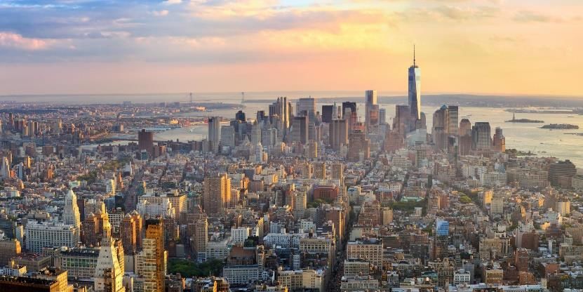
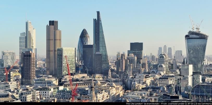
Theme: Gallery Rebels Cross-Curricular Links
London v New York - History – Buildings of significant historical interest
Tourism Maths – currencies of the world
Art – Famous art galleries of the world
Key Vocabulary Geographical Skills and Fieldwork
Tourism, currency, language, • Understand geographical similarities and differences through the study of human and physical geography of a region of the United
climate, transport links, travel, Kingdom, a region in a European country, and a region within North or South America.
economy
Knowledge to be taught:
London New York
• Key Tourist Hotspots (including galleries): • Key Tourist Hotspots (including galleries):
o Big Ben and the Houses of o Statue of Liberty
Parliament o Empire State Building
o Buckingham Palace o Central Park
o Hyde Park o Times Square
o Marble Arch o Metropolitan Museum of Art
o Trafalgar Square o One World Trade Centre
o Whitehall and Downing Street o Guggenheim Museum
o The London Eye o Grand Central Terminal
o St Paul’s Cathedral o Broadway
o The National Gallery
o Tower of London • Currency – American Dollar ($)
o National History Museum • Language – English
o Tate Modern • Climate – Humid Subtropical
o The National Portrait Gallery • Transport Links – The Subway
• Currency – Pound Sterling (£)
• Language – English
• Climate – Temperate
• Transport Links – The London Underground
Definitions
Economy - the state of a country or region in terms of the production and consumption of goods and
services and the supply of money.Progression in Key Geographical Concepts
EYFS End of Key Stage One Lower Key Stage Two Upper Key Stage 2
• Locate their house from a • Name, locate and identify characteristics • Locate the Northern Hemisphere, • Locate famous rivers around the
photograph of their of the four countries and capital cities of Southern hemisphere, Tropic of Cancer globe.
street/Google maps. the United Kingdom and its surrounding and Tropic of Capricorn on a world map • Name and locate the countries of
seas on a map. and on a globe. Europe on a map and a globe.
• Name and locate the world’s seven • Locate lines of latitude and longitude on a • Name and locate the countries in
Locational Knowledge
continents and five oceans on a map and map of the world and identify the Prime North and South America on a
a globe. (Greenwich) meridian running through world map and a globe.
• Locate the position of the Equator, North London.
Pole and South Pole on a world map and • Locate Lincolnshire and it’s adjoining
a globe. counties on a map of England.
• Locate Lincoln on a map of the United • Name and locate major mountain ranges
Kingdom. of England and Scotland.
• Name and locate major rivers of Scotland
and England.
• Locate major English cities.
• Name and locate the tallest mountains of
the World
• Describe some • Use geographical language to describe • Use geographical language to compare • Compare land use in UK cities
geographical features of the human and physical features of a the rural and urban areas of Lincolnshire during the Second World War to
the immediate Lincoln eg. Lincoln Cathedral, Brayford eg. commercial centre, university, land use in these cities today.
environment. Pool, River Witham, bus station, quarry, factories, leisure facilities, farmland, farm • Compare a region of North
• eg. house, street, road,
Investigating Places
woodland, stream, grassland buildings, food manufacturing plants America with the city of London.
garden, garage, trees • Use geographical language to describe • Describe the physical features of Focus on the human and physical
the human and physical features of Lincolnshire that make it suitable for features of New York and London
Rajasthan (a contrasting non-european arable farming. and their impact on tourism.
country) eg. desert, salt water lakes,
mud/straw huts, agricultural land
• Use geographical language to describe
the human and physical features of the
British coast (Skegness and Scarborough)
eg. beach, sand dunes, promenade, hotel,
cliffs, headland, golf course, clock tower• Describe types of • Identify seasonal and daily weather • Describe and understand key aspects of • Describe and understand the key
weather seen in the local patterns in the United Kingdom. volcanic eruptions including the layers of features of rivers including the
area. • Identify the location of hot and cold areas the earth and the action plate tectonics. processes of erosion and
Natural Processes
of the world in relation to the Equator • Describe and understand why some areas deposition.
and the North and South Poles of Lincolnshire are prone to flooding. • Describe and understand the water
Describe how flooding occurs (high tides, cycle.
low lying land) and how the coast can be • Describe the climate zones and
protected. biomes of the world and
• Describe and understand the process of understand how they are affected
mountain formation. by weather and position on the
globe (link back to tropics of
Cancer and Capricorn and the
equator.
• Use a simple tick sheet to • Use world maps, atlases and globes to • Use the eight points of the compass and • Use the sixteen points of the
record what has been identify the United Kingdom and its positional language to describe the compass and positional language to
seen on a walk to the countries. location of features and routes on a map. describe the location of features on
local shopping precinct. • Use aerial photographs and maps to • Recognise Ordnance Survey map symbols a map.
• Use computer mapping locate the key physical and human and use this to describe land use from an • Record weather patterns in the
Geographical Skills & Field work
and Google Street View features of Lincoln. Ordnance Survey map. immediate environment over a
to locate their street and • Devise a simple map of the school and use • Explore maps with contours to period of one month including:
house. basic symbols for a key. understand how height is represented. • Rainfall
• Survey the traffic that • Use the four points of the compass • Wind speed
goes past school. (north, south, east and west) and simple • Wind direction
positional language (near, far, left and • Temperature
right) to describe the location of features • Undertake sound mapping in the
and routes on a map. local nature reserve (Greetwell
Hollow)
• Measure the depth of a stream at
regular intervals.
• Take photographs to record the
human and physical features of
Greetwell HollowYou can also read