China's Alternative to GPS and its Implications for the United States - U.S.-China Economic...
←
→
Page content transcription
If your browser does not render page correctly, please read the page content below
January 5, 2017

China’s Alternative to GPS and its
Implications for the United States
Jordan Wilson, Policy Analyst, Security and Foreign Affairs

Disclaimer: This paper is the product of professional research performed by staff of the U.S.-China Economic and Security Review
Commission, and was prepared at the request of the Commission to support its deliberations. Posting of the report to the Commission’s
website is intended to promote greater public understanding of the issues addressed by the Commission in its ongoing assessment of U.S.-
China economic relations and their implications for U.S. security, as mandated by Public Law 106-398 and Public Law 113-291. However,
the public release of this document does not necessarily imply an endorsement by the Commission, any individual Commissioner, or the
Commission’s other professional staff, of the views or conclusions expressed in this staff research report.

Executive Summary
China’s Beidou satellite navigation system is projected to achieve global coverage by 2020, providing position
accuracies of under ten meters (one meter or less with regional augmentation) using a network of 35 satellites.
While the United States has provided GPS signals to users worldwide for free since the 1980s, China has sought to
field its own satellite navigation system in order to (1) address national security requirements by ending military
reliance on GPS; (2) build a commercial downstream satellite navigation industry to take advantage of the quickly
expanding market; and (3) achieve domestic and international prestige by fielding one of only four such global
navigation satellite systems (GNSS) yet developed, cementing China’s status as a leading space power and opening
the door to international cooperation opportunities. Beidou is consistently referenced as one of China’s top space
projects in its government white papers on space activities, most recently in December 2016.
China’s development and promotion of Beidou presents implications for the United States in security, economic,
and diplomatic areas. It is of foremost importance in allowing China’s military to employ Beidou-guided
conventional strike weapons—the buildup of which has been a central feature of Beijing’s efforts to counter a U.S.
intervention in a potential contingency—if access to GPS is denied. The concern has also been raised that Beidou
could pose a security risk by allowing China’s government to track users of the system by deploying malware
transmitted through either its navigation signal or messaging function (via a satellite communication channel), once
the technology is in widespread use. However, industry professionals interviewed for this report (1) are not aware
of ways to feasibly transmit malware through a navigation signal and (2) assess that manufacturers will be unlikely
to include the messaging function due to cost factors. Restrictions on technology purchases from China by U.S.
government and military users can help guard against malware being physically installed. As Beidou-equipped
smartphones become more prevalent, U.S. consumers should know there are no inherent risks to receiving Beidou
signals when the satellite communication function is not included.
In economic terms, GPS and Beidou signals are both provided for free and are not in “competition” for market
share. Further, experts widely agree that the satellite navigation industry is trending toward “multi-constellation”
receivers that work with all GNSS. This development will bring greater accuracy to consumers at minimal marginal
cost and is supported by governments around the world. The U.S. firms that currently dominate the downstream
satellite navigation industry will thus likely be able to incorporate Beidou functionality and continue to compete
both in China and the global market, despite steps China has taken to protect its companies in the industry. China’s
subsidies and preferential taxation policies pose a larger problem, as these are likely to primarily benefit domestic
companies. Further, state-affiliated customers in China will probably avoid U.S. technologies once China’s industry
becomes mature. This development will likely narrow opportunities for U.S. firms in the long term, as has been
typical of non-Chinese firms’ experience in the China market across a wide range of industries.
Finally, Beidou will likely bring enhanced prestige and diplomatic opportunities for China’s government. The
system could provide Beijing with leverage to obtain more influence in several international and regional
organizations that deal with global satellite navigation issues. Further, China plans to expand Beidou coverage to
most of the countries covered in its “One Belt, One Road” initiative by 2018, indicating it sees the system as playing
a role in its economic diplomacy efforts. China has also sought to incentivize nearby countries, most notably
Thailand, to begin using Beidou receivers, and seeks access to build a network of differential ground stations
throughout Asia—perhaps 1,000 in Southeast Asia alone—to improve the system’s accuracy and, by extension,
Chinese companies’ commercial prospects. These stations will not have a direct effect on U.S. regional influence
or U.S. firms in downstream industries (which can also build receivers that utilize them), should trends towards
interoperability continue.
In response to these developments, the United States can: consider allowing government and military users to take
advantage of multi-constellation devices, continuing to monitor the industry to assure that security threats do not
materialize; promote interoperability to ensure its firms remain competitive; and continue to invest in maintaining
its leadership in space.

U.S.-China Economic and Security Review Commission                                                                  2

Introduction
Since 1994 China has spent billions of dollars to develop a product that is already free: satellite navigation services
provided globally by the U.S. Global Positioning System (GPS). This report examines the objectives behind
Beijing’s decision to develop the Beidou system as an alternative to GPS, its efforts to build an industry around the
system, and the effects this might have in security, economic, and diplomatic terms for the United States. As China
nears its goal of providing global satellite navigation coverage by 2020 and growing numbers of Beidou-configured
products enter the vast downstream market, considering these implications will become increasingly important.
Background: Satellite Navigation and its Impacts
Global Navigation Satellite Systems (GNSS), which GPS and its predecessor systems pioneered, provide
positioning, navigation, and timing (PNT) information by broadcasting radio signals to devices on the ground. In
the case of GPS, receiving these signals from at least four satellites at different points in a GNSS constellation
allows the calculation of the receiver’s location, velocity, and local time.* 1 Four such systems are currently in
development or operation:
The United States’ GPS, initiated in 1978† and achieving global coverage in 1995.2 GPS typically provides
positioning accuracies of under 2.2 meters, which can be improved to as low as a few centimeters with the
use of augmentation systems.3 Ground-based augmentation systems rely on a network of ground stations
to boost accuracy,4 while satellite-based augmentation systems use a different network of satellites to do
so.5
Russia’s Global Navigation Satellite System (GLONASS), initiated in 1982 and achieving global
coverage in 1996, and again in 2011 (after the system had fallen into disrepair).6 GLONASS provides
positioning accuracies of 2.8 meters, and Russia is developing a satellite-based augmentation system
primarily focused on Russian territory.7
The European Space Agency’s Galileo system, initiated in 2005 and projected to provide global coverage
by 2020.8 Galileo will provide positioning accuracies of one meter with its open service and one centimeter
with its restricted commercial service.9
China’s Beidou system, initiated in 1994 and projected to provide global coverage by 2020.‡ 10 Beidou will
reportedly provide positioning accuracies of under ten meters worldwide, improving to one meter or even
less with the use of a forthcoming ground-based augmentation system focused on China.11
GPS began as a U.S. military project and has had a transformative impact in the global security realm. Military
strategists identify space-based PNT as a significant factor in the “Revolution in Military Affairs (RMA)”§ that
began in the early 1990s, one of only a handful of such revolutions that have transformed warfare throughout history.
A GNSS specifically allows the guidance of sensor-equipped platforms and missiles to precise positions, creating
a “reconnaissance-strike complex” when combined with advances in gathering and disseminating information and
in command and control.12 The development of precision-guided munitions in large quantities has been the central
feature of China’s “antiaccess/area denial (A2/AD)” objective within its People’s Liberation Army (PLA)
missions, ** intended to make a U.S. military intervention in the Western Pacific more costly. GPS, Galileo,
* The time elapsed between sending and receipt, multiplied by the standard rate at which these radio waves travel, yields the distance from
each satellite to the receiver. These distances are then used to determine location through the geometric method of trilateration. National
Coordination Office for Space-Based Positioning, Navigation, and Timing, Trilateration Exercise, November 25, 2014.
http://www.gps.gov/multimedia/tutorials/trilateration/.
† The beginning year listed is the year in which the first satellite associated with the program (including test satellites) was launched.
‡ India and Japan have also begun navigation satellite system programs, but these are intended to complement or back up existing GNSS
systems in certain regions rather than to provide global coverage on their own. Government of Japan Cabinet Office, What is the Quasi-
Zenith Satellite System (QZSS)?; Ishan Srivastava, “How Kargil Spurred India to Design Own GPS,” Times of India, April 5, 2016.
§ According to analysts at the Strategic Studies Institute of the U.S. Army War College, “most analysts define a RMA as a ‘discontinuous
increase in military capability and effectiveness’ arising from simultaneous and mutually supportive change in technology, systems,
operational methods, and military organizations.” James Kievit and Steven Metz, “Strategy and the Revolution in Military Affairs: From
Theory to Policy,” Strategic Studies Institute, June 1, 1995, vi, 7. http://www.au.af.mil/au/awc/awcgate/ssi/stratrma.pdf.
** According to the U.S. Department of Defense, “antiaccess” actions are intended to slow the deployment of an adversary’s forces into a
theater or cause them to operate at distances farther from the conflict than they would prefer. “Area denial” actions affect maneuvers within
U.S.-China Economic and Security Review Commission 3GLONASS, and Beidou each have a restricted signal that provides higher accuracies,13 reflecting the ongoing
military impact of GNSS. U.S. experts and defense officials have also argued that configuring military systems to
work with multiple GNSS, an approach known as “diversification,” could help back up GPS in the future.14
GPS and follow-on systems have had revolutionary commercial impacts as well. Even before GPS was declared
operational, industry developed ways to exploit it for high precision surveying and other professional applications.
Since the United States ended the intentional downgrading of public GPS signals in 2000,* 15 downstream consumer
industries have developed rapidly: personal navigation assistants used while driving, followed by in-dash systems
pre-installed in automobiles, followed by applications for smartphones and other devices, with new trends including
GNSS-equipped wearable technology and autonomous vehicle navigation.16 These developments have occurred in
a surprisingly short period of time, yielding an industry worth $82.4 billion in 2014 and forecast to grow 7 percent
annually on average through 2023, with 3.6 billion GNSS devices in use worldwide.17 Today’s GNSS downstream
industry can be broadly divided into (1) component manufacturers, which produce receivers for stand-alone use or
integration into systems; (2) system integrators, which integrate GNSS capability into larger products such as
vehicles, consumer electronics, and personal navigation assistants; and (3) value-added service providers, which
offer GNSS-enabled software such as maps, telecommunications, and location-related data downloads (e.g. Google
Maps, Waze, Uber, Skype, and any weather application).18 As of 2012 the United States led with 31 percent of the
total downstream market, followed by Japan with 26 percent, Europe with 25.8 percent, and China with 7 percent.
The GNSS market is highly consolidated, particularly at the level of component manufacturers.† 19
Lastly, the global downstream GNSS industry is moving rapidly towards “multi-constellation” devices, built to
receive signals from two, three, or all four of the GPS, GLONASS, Galileo, and Beidou systems. 20 The European
Global Navigation Satellite Systems Agency’s 2015 market report notes that “almost 60 percent of all available
receivers, chipsets and modules are supporting a minimum of two constellations, showing that multi-constellation
is becoming a standard feature across all market segments” (GPS is included in one hundred percent of these multi-
source devices). 21 U.S. company Qualcomm Inc., the leading global manufacturer of satellite navigation
components, has produced chips that support GLONASS (along with GPS) for roughly the past four years, Beidou
for roughly two years, and Galileo for roughly one year.22 This trend is being driven by technical, economic, and
political factors:
The multi-constellation feature will likely provide consumers with greater reliability and accuracy than a
single GNSS can provide, especially in urban environments,23 meaning that single-constellation devices
will probably not be competitive in the future, except in the most cost-constrained markets.24
Although there are incremental software development costs in adding new constellations for receiver
chipset manufacturers, there is little extra hardware cost, and the software can largely be reused in future
products.25
This development is actively supported by governments around the world: the ultimate goal of the
International Committee on GNSS of the UN Office of Outer Space Affairs is “to achieve compatibility
and interoperability of GNSS systems;”‡ 26 the United States officially seeks to “engage with foreign GNSS
a theater, and are intended to impede an adversary’s operations within areas where friendly forces cannot or will not prevent access. U.S.
Department of Defense, Military and Security Developments Involving the People’s Republic of China 2013, 2013, i, 32, 33; U.S.
Department of Defense, Air-Sea Battle: Service Collaboration to Address Anti-Access & Area Denial Challenges, May 2013, 2.
* According to official U.S. policy, the United States has no intention of ever resuming this intentional downgrading, and the next generation
of GPS satellites will not even have this capability. In a case in which the United States desired to prevent a potential adversary from using
GPS, the U.S. military “is dedicated to the development and deployment of regional denial capabilities in lieu of global degradation.”
National Coordination Office for Space-Based Positioning, Navigation, and Timing, Selective Availability, September 23, 2016.
http://www.gps.gov/systems/gps/modernization/sa/; National Coordination Office for Space-Based Positioning, Navigation, and Timing,
Frequently Asked Questions Regarding Selective Availability, September 24, 2013.
http://www.gps.gov/systems/gps/modernization/sa/faq/#dgps.
† For examples of leading companies in these sectors, as of 2012 Qualcomm (U.S.), Trimble Navigation (U.S.), and Broadcom (U.S.) were
the three leading component manufacturers; Toyota (Japan), Garmin (Switzerland), and General Motors (U.S.) were the leading system
integrators—Apple (U.S.) and Samsung (Korea) were also top 10 players—and Google (U.S.), Pioneer (Japan), and Denso (Japan) were
the leading value-added service providers, with Microsoft (U.S.) also in the top 10. European Global Navigation Satellite Systems Agency,
GNSS Market Report 4 March 2015, 11. http://www.gsa.europa.eu/system/files/reports/GNSS-Market-Report-2015-issue4_0.pdf.
‡ The UN Office for Outer Space Affairs defines “compatibility” as “the ability of global and regional navigation satellite systems and
augmentations to be used separately or together without causing unacceptable interference and/or other harm to an individual system and/or
U.S.-China Economic and Security Review Commission 4providers to encourage compatibility and interoperability” and to encourage the use of foreign PNT services
“to augment and strengthen the resiliency of GPS;”27 and Chinese officials have also expressed support for
interoperability, including in the government white paper on Beidou released in 2016.28 The United States
and China began bilateral consultations on civil cooperation related to GPS and Beidou in 2014.29
China’s Objectives for the Beidou System
Beidou today features 23 satellites in medium Earth and geosynchronous orbits,* 30 providing regional coverage at
accuracies of under ten meters (a separate military signal likely provides higher accuracies).31 Chinese officials state
that when complete, Beidou will consist of 35 satellites and provide positioning accuracies of under ten meters
worldwide, improved in China to one meter and even centimeters in some areas with the use of a forthcoming
“differential Beidou” system, which will use a network of thousands of ground stations to boost accuracy.32 China
also aims to develop a global satellite-based augmentation system in the future, and has stated its desire that this be
interoperable with other countries’ augmentation systems. 33 China announced in May 2016 that it would launch a
total of 30 Beidou satellites during the 13th Five Year Plan period (2016-2020) to reach this objective (satellites
become defunct and must be replaced, accounting for the discrepancy).34 China reportedly spent $2.57 billion on
the Beidou program from 1994 to 2012 and planned (as of 2013) to spend an additional $6.41-$8.02 billion from
2013 to 2020, indicating it is one of the largest space programs the country has undertaken. Beidou is also one of
China’s 16 “megaprojects” under the 2006-2020 Medium and Long-Term Plan for Science and Technology
Development.35 It is consistently referenced as one of China’s top space projects in its government white papers on
space activities, most recently in 2016.36
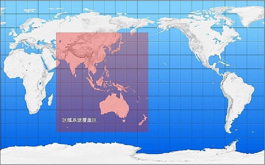
Figure 1: Diagram of Future Beidou Constellation and Current Coverage
Source: China Satellite Navigation Office, “Beidou: Bring the World and China to Your Doorstep” (5th Session of the Committee on the
Peaceful Uses of Outer Space, UN Office for Outer Space Affairs, Vienna, Austria, June 6-15, 2012).
http://www.oosa.unvienna.org/pdf/pres/copuos2012/tech-07.pdf.
Just as GPS was originally driven by military objectives, China made the determination to develop Beidou based
on perceived security requirements, as described in the Commission’s 2015 Annual Report to Congress:
service.” It defines “interoperability” as “the ability of global and regional navigation satellite systems and augmentations and the services
they provide to be used together to provide better capabilities at the user level than would be achieved by relying solely on the open signals
of one system.” United Nations Office for Outer Space Affairs, International Committee on Global Navigation Satellite Systems (ICG):
Providers’ Forum, 2016. http://www.unoosa.org/oosa/en/ourwork/icg/providers-forum.html.
* Medium Earth orbit is the classification of orbits between 1,200 and 22,300 miles above the Earth’s surface. At semisynchronous orbit
(about 12,400 miles), satellites circle the Earth every 12 hours, ideal for precision timing and navigation satellites. Geosynchronous Earth
orbit can be achieved at about 22,000–23,000 miles above the Equator. The highest orbital band within this classification in frequent use
is known as “geostationary Earth orbit.” At this altitude, satellites move at the same speed as the Earth’s rotation, enabling them to cover
large geographic areas. Beidou includes satellites in medium Earth orbit, inclined geosynchronous orbit, and geostationary Earth orbit.
State Council Information Office of the People’s Republic of China, China’s Beidou Navigation Satellite System, June 2016.
http://english.gov.cn/archive/white_paper/2016/06/17/content_281475373666770.htm.
U.S.-China Economic and Security Review Commission 5The PLA has considered [its] dependence on a foreign PNT system to be a strategic vulnerability since at
least the mid-1980s. These fears were exacerbated during the 1995–1996 Taiwan Straits Crisis. According
to a retired PLA general, the PLA concluded that an unexpected disruption to GPS caused the PLA to lose
track of some of the ballistic missiles it fired into the Taiwan Strait during the crisis. He then said that ‘it
was a great shame for the PLA … an unforgettable humiliation. That’s how we made up our mind to develop
our own global [satellite] navigation and positioning system, no matter how huge the cost. Beidou is a must
for us. We learned it the hard way.’37
China undertook its massive effort to build a commercial industry compatible with the system later, after the U.S.
government stopped degrading the civil GPS service in 2000 and the commercial potential of GNSS became fully
evident. In an indication that the commercial driver has become highly important, the 2016 government white paper
on Beidou calls for the implementation of central, state, and local policies to support the development of Beidou
applications and industrial products; investment in applying Beidou technologies and products to “key sectors
related to national security and [the] economy;” and investment in research and development of “chips, modules,
antennae and other basic products” to be used with Beidou and other compatible systems—ultimately seeking to
build an “industrial chain” comprising all parts of the downstream industry. The white paper also announced
officially for the first time that Beidou (like GPS) would be free to all users worldwide. 38 In 2013 China publicly
released Beidou’s interface control document, containing the technical information required to develop receivers
compatible with the system,39 as was done for other GNSS.
The total output of China’s navigation services sector exceeded $25 billion (173.5 billion renminbi) in 2015 and is
expected to top $58 billion (400 billion RMB) in 2020, according to the most recent white paper published by the
Global Navigation Satellite System and Location Based Services Association of China. This represented a year-on-
year growth rate of 29 percent, with 20 to 30 percent growth rates predicted for the coming years. The white paper
also noted that 466 million PNT end products, including 440 million smartphones, were sold in China in 2015 alone.
The market penetration of Beidou is close to 20 percent, but the document states that it is expected to reach 60
percent by 2020.40 According to Davof Xu, GNSS China Project Manager for the European Union Chamber of
Commerce in China, there are over 14,000 companies and organizations active in the GNSS-related industry in
China, accounting for a total of more than 450,000 employees.41 The industry’s rapid growth along with China’s
relatively low current market share, latecomer status, and fragmented market (Chinese GNSS companies are mostly
small- and medium-sized in comparison to highly consolidated global providers42) likely indicates to Beijing an
opportunity for significant economic benefits down the road.
Beidou’s development thus far indicates several key political objectives as well. China’s leadership views its efforts
in space as providing both domestic and international prestige,43 and the development of one of the world’s first
satellite navigation systems is likely seen as a main contributor in this regard. Officials have been quick to tout
occasions in which receivers in various fields utilize “China’s own Beidou system.”44 One 2015 state-run media
report emphasized that 98 percent of the components in the newest Beidou satellites were made in China, with
international commenters noting that this domestic sourcing demonstrated China’s status as a leading space power.45
At the technical level, Beidou offers a short messaging service through which messages of up to 120 characters can
be sent to other Beidou receivers, unlike GPS.46 Via this service, Chinese fishing vessels are reportedly able to
sound “instant alarms” to fishing departments when emergencies arise, while a supplementary “vessel management
system” allows them to request assistance from nearby vessels.47 This feature is particularly relevant to the ongoing
disputes in the South China Sea, where fishing rights are at stake and where China’s maritime militia—a quasi-
military force of fishermen that are tasked by and report to the PLA—plays a key role in advancing Beijing’s
claims.48 The international cooperation opportunities provided by Beidou have also become a tool for Beijing to
use within its larger foreign policy approach, as discussed further below.
Preferential Policies to Promote Beidou
While Beidou is provided for free and does not “compete” with other satellite navigation systems, Beijing has
undertaken a host of domestic policies to promote the adoption of Beidou-compatible receivers and expand its
GNSS industry. Most notable are rules requiring the installation of Beidou receivers on 80 percent of all buses and
trucks in nine provinces (out of 34 provincial-level administrative units total), mandating that new heavy trucks and
U.S.-China Economic and Security Review Commission 6semi-trucks have factory-installed Beidou receivers,49 and offering subsidies for the purchase of shipborne Beidou
receivers for fishing boats.50 For context, Russia has mandated the use of GLONASS across a range of sectors,
including “critical infrastructure” and government applications, 51 and Europe has considered mandates for
Galileo;52 the United States recommends technology-neutral, performance-based standards.53 However, Beijing has
also pledged funding for various sectors of the industry in numerous government plans, most notably the 2013
National Navigation Satellite Industry Medium- and Long-Term Development Plan, which states that China will
seek to have its companies capture 60 percent of the domestic GNSS applications market (and 80 percent of
“important” applications) and become globally competitive by 2020. The plan also encourages the improvement of
financial and taxation policies to help domestic firms in the industry expand to international markets.54 Provincial
governments have issued plans for satellite navigation industry development as well; Henan’s June 2016 plan calls
for fiscal and tax policy support, the establishment of industrial parks, and government procurement support,
particularly for products from the province.55
At the international level, China has sought to incentivize nearby countries to begin using Beidou receivers, in order
to prove the technology’s viability and prepare its companies to compete globally in the future. This began when
China signed a roughly 2 billion yuan ($297 million) agreement with Thailand in 2013, reportedly funded mostly
by Beijing as part of its foreign aid program, to promote the use of Beidou in Thailand’s public sector in areas such
as disaster relief, power distribution and transportation.56 According to one Chinese academic expert, Beijing saw
Thailand as an ideal starting point as its heavy reliance on GPS would allow China to demonstrate that “Beidou can
do anything GPS does;” one official additionally stated that “to cooperate with Thailand … is to bring Beidou to
Southeast Asia.”57 China has since reached agreements with Brunei, Laos, and Pakistan to provide Beidou-equipped
infrastructure for government and military users, also at heavily subsidized costs. These agreements have included
provisions allowing China to build differential ground stations in each country to increase the system’s accuracy on
the ground.58 China has also been in talks with several countries in the Middle East, including Saudi Arabia and
Egypt, regarding assistance from Beijing in introducing Beidou-based services, and the first “China-Arab States
Beidou Cooperation Forum” is planned for 2017.59 China has stated it plans to expand Beidou coverage to most of
the countries covered in its “One Belt, One Road” initiative* by 2018 on the way to global coverage in 2020,60 and
has emphasized these countries in its promotion efforts.61 Lastly, China and Russia have agreed to establish a joint
venture to develop and market satellite navigation devices compatible with Beidou and GLONASS. Additionally,
each country will establish three differential stations in the other country.62
Implications for the United States
The original military purpose of Beidou and China’s current diplomatic and commercial efforts involving the system
present important implications for the United States.
Military and Security Implications
If, as projected, Beidou achieves global coverage by 2020, China’s military will complete its shift away from
reliance on GPS for precision strike. Beidou’s initial deployment has already been focused on providing coverage
in the Asia Pacific region (as shown in Figure 1), the area in which China’s ground-, air-, and sea-launched missiles
would likely be employed in a counterintervention scenario. Public information about China’s incorporation of
Beidou into its weapons systems is scarce, as the Commission noted in its 2015 Annual Report to Congress, but
China is almost certainly equipping its ballistic and cruise missiles to operate with both GPS and Beidou. If true,
PLA operators could switch to Beidou to guide a missile to its target if GPS were denied, and China would also be
able to attack an adversary’s access to GPS without disrupting its own capabilities. The PLA has likely also been
using Beidou for positioning and maneuvering, friendly force tracking, and secure communications since the late
2000s.63 Most military facilities, lighthouses, and fishing boats have been using the system since 2012, according
to Chinese officials.64 In the long term, should China succeed in developing its downstream GNSS industry, the
* President Xi Jinping’s “One Belt, One Road” initiative involves major infrastructure projects in ports and railways throughout the region.
It is composed of a land-based “belt” through Central Asia and a maritime “silk road” counterpart that will run through Southeast Asia and
the Indian Ocean to Africa and the Mediterranean Sea. U.S.-China Economic and Security Review Commission, 2015 Annual Report to
Congress, November 2015, 168.
U.S.-China Economic and Security Review Commission 7PLA will additionally have its own domestic “industrial chain” on which to draw for secure components. In 2015
private Chinese firm Alibaba and state-owned defense conglomerate China North Industries Corporation
(NORINCO) formed a joint venture worth roughly $310 million to “build applications and technology to support
and work with the [Beidou] system,” indicating China is already seeking to leverage civil-military integration in
GNSS.65
Concerns have also been raised regarding inherent security vulnerabilities in Beidou-equipped receivers. For
example, Taiwan’s Ministry of Science and Technology stated in a report to the country’s legislature in May 2016
that Beidou can “track” smartphone users via embedded malware in devices containing Chinese-manufactured
satellite navigation chips, and thus poses an information security risk to Taiwan.66 It is of course already possible
to track a GPS-equipped device (using the “Find My iPhone” application, for example); this concern would involve
a device’s location being shared unknowingly due to malware. The Taiwan government report mentions that in the
case of Beidou such malware could originate from chips manufactured by Chinese companies or from the Beidou
navigation signal or messaging service directly (similar to recent instances of malware distribution via SMS text
messages).67 The report announced a range of measures across military and commercial sectors to address this
vulnerability, including requiring distributors to identify products equipped for use with Beidou, compiling a list of
Beidou-compatible applications and testing them for malware, calling on civil servants to avoid buying or using
products or applications that use Beidou, monitoring the Beidou signal to detect anomalies that might indicate a
hack, and considering a ban on the import and sale of Beidou-equipped devices entirely. 68 The 2017 National
Defense Authorization Act bans the U.S. military from using any “non-allied” PNT system (i.e. GLONASS or
Beidou) for a period of time absent a waiver from the U.S. Secretary of Defense, and requires an assessment of the
risks of utilizing such systems by April 22, 2017,69 indicating this is a pressing question in the United States as well.
Technical experts interviewed for this report, however, noted that (1) they are not aware of ways to feasibly transmit
malware through a navigation signal; and (2) receiver chip manufacturers will be unlikely to include the “texting
service” due to cost factors. 70 Jim Mollenkopf, Senior Director of Strategic Development for Qualcomm
Government Technologies, stated that “Qualcomm’s products only use Beidou for passive reception of navigation
signals, and do not use the Beidou messaging function. We know of no way for the Beidou system to track users
without the messaging function enabled.”* 71 David Stelpstra, a geodetic engineer at Dutch company TomTom NV,
noted that transmission requires a great deal of power and manufacturers would not want to include this feature, as
battery capacity is a bottleneck for portable navigation devices.72 Another engineer concurred, stating:
If the hardware is ‘receive only,’ there is no way to transmit. Adding transmit would double the cost and
complexity, so most chip manufacturers would not implement it, except for the China-specific brands for
the [Chinese] fishing vessels and other very specialized systems. So the answer is yes, there could be a
security risk, but that would track a very limited band of people that are likely locals anyways.73
Thus, should global manufacturers avoid including the Beidou messaging service as predicted, and should U.S.
government buyers avoid using products manufactured by Chinese companies with a higher risk of malware being
physically installed, these security vulnerabilities would be mitigated. In addition, U.S. military systems may be
able to safely utilize a diversity of PNT systems in the future, pending military and intelligence community
confirmation of these private sector assessments. Lastly, given that one-third of the smartphones exported from
China in the first quarter of 2016 reportedly contained Beidou receiver chips,74 U.S. consumers should know that
there are no inherent risks involved in a smartphone having Beidou connectivity if it does not include the satellite
communication channel. However, the risk of malware being installed if a Chinese company is the original
* Mr. Mollenkopf provided the following more detailed technical explanation of why this is the case: “For Beidou to introduce malware to a
smartphone, the Beidou navigation signal would need to somehow be converted to program code without being rejected as corrupt
(unlikely), and then the phone would need to be crashed and somehow vectored to look into GNSS system memory for software program
instructions (probably through some other non-Beidou mechanism) and then run the offending code to create a malicious effect.
Qualcomm’s products include a number of measures to prevent each and every step in this chain of events and we consider it exceedingly
unlikely.” Mr. Stelpstra agreed, noting that “the encryption of malware in the navigation messages is highly unlikely because this will alter
the transmitted orbits and therefore make the use of that satellite impossible for position determination of the receiver.” Jim Mollenkopf,
Senior Director, Strategic Development Qualcomm Government Technologies, interview with Commission staff, October 14, 2016; David
Stelpstra, Geodetic Engineer, TomTom NV, interview with Commission Staff, October 14, 2016.
U.S.-China Economic and Security Review Commission 8equipment manufacturer of the smartphone (unlike those that dominate the U.S. market today) should be carefully considered. Diplomatic Implications As the Commission noted in its 2015 Report, Beidou’s achievement of global coverage could provide Beijing with leverage to obtain more influence over PNT-related decisions in several international and regional organizations that deal with these issues, such as the International Telecommunications Union, the International Committee on Global Navigation Satellite Systems, the Asia-Pacific Economic Cooperation forum, and the International Civil Aviation Organization. 75 In 2014 the International Maritime Organization—the UN agency that sets safety standards for international shipping76—approved a Beidou-equipped receiver for the first time, viewed by China as a milestone in its pursuit for the system’s international adoption.77 As with other major space projects, Beidou’s achievements should be expected to benefit the prestige and soft power aims of China’s government, particularly as it reaches parity in a longstanding area of U.S. dominance. Beyond providing influence in international organizations, Beidou will likely contribute to China’s broader foreign policy approach toward specific countries and regions in its early days as a global system. China’s statement that it plans to expand Beidou coverage to most of the countries covered in its “One Belt, One Road” initiative by 2018 indicates that it sees the system as playing a role in its economic diplomacy efforts. Beijing’s January 2016 “Arab Policy Paper” specifically identifies plans to accelerate the application of Beidou services to Arab countries as contributing to Beijing’s regional infrastructure development and space cooperation objectives.78 Mr. Xu assesses that countries in Asia desire to avoid reliance on GPS alone,79 a demand China can meet with its free alternative. This demand may extend to military systems equipped with Beidou as well, meaning U.S. suppliers may need to produce both Beidou- and non-Beidou-equipped products if buyers such as the United States government restrict the use of non-allied GNSS in their military systems. Otherwise, once Beidou has gone global and multi- constellation devices have become the norm, Beijing’s ability to reap continued diplomatic benefits will likely be limited. Importantly, in many cases China’s engagement is likely intended not for broader diplomatic aims but to facilitate Beidou’s practical requirements. One example is Beijing’s plan to construct a network of differential ground stations throughout Asia—perhaps 1,000 in Southeast Asia alone 80 —to increase the system’s local accuracy. 81 These stations are likely to be a standard component of all GNSS going forward, and will not have a direct effect on U.S. regional influence or commercial interests should trends towards interoperability continue. However, U.S. legislation passed in 2013 prevents foreign ground monitoring stations from being installed on U.S. soil, unless it can be certified that they “will not possess the capability or potential to be used for the purpose of gathering intelligence in the United States or improving any foreign weapon system.”82 Russia shut down U.S.-provided science community GPS stations on its soil in 2014, ostensibly in retaliation for its inability to install differential ground stations for GLONASS in the United States,83 indicating that Beidou stations may also prove to be a source of diplomatic tension. Commercial Implications The global trend toward product compatibility with multiple constellations may actually create additional opportunities for U.S. companies in China in the near term, as assessed in a report by the University of California Institute on Global Conflict and Cooperation (IGCC) released by the Commission in July 2016. Qualcomm provided the GNSS component technology for the first GPS- and Beidou-compatible smartphone—the China market version of the Samsung Galaxy Note 3—in 2013, for example. 84 China’s public release of Beidou’s interface control document (as done with other GNSS) indicates a desire for some level of international participation, and an official with the China Satellite Navigation Office noted in 2014 that “Chinese companies can only grow by engaging in face-to-face competition with the world’s top companies in the industry.”85 It is important to note, however, that it takes roughly one to two years to add a new constellation to product software, 86 a disadvantage for foreign companies that have not yet developed Beidou compatibility, and that China’s government has still taken steps to protect its companies: U.S.-China Economic and Security Review Commission 9
Chinese companies were given early access to Beidou reference designs and specifications, providing an
early advantage in developing Beidou products
China has established certification hurdles seemingly targeting non-Chinese vendors87
Qualcomm was not allowed to join China’s GNSS standards committee alongside domestic firms88
It will thus likely take time for U.S. firms in China’s domestic market to take advantage of the commercial shift
toward multi-constellation devices, although this trend has the potential to eventually reduce the impact of Beijing’s
mandates.
In the long term, a far different outlook emerges. China’s preferential financial and taxation policies aimed at
promoting Beidou are likely to negatively impact U.S. companies operating in China’s market, according to the
IGCC report, as most of these incentives are likely to be given primarily to local Chinese companies. Of greater
concern, U.S. suppliers will likely be replaced by local ones for Chinese government and military users seeking
“secure and controllable” options. The report states that it is unclear how broadly this typically occurs in the civilian
market, but the long-term outcome for U.S. firms in the industry will likely be negative.89
In the international market, U.S. companies will likely be able to configure their products to work with the
constellations prevalent in each region and compete with fewer obstacles than in China’s domestic market. From
this perspective, rapid movement towards full interoperability between satellite navigation systems will continue to
be in the interests of the United States. Challenges specific to the downstream satellite navigation industry in China
should be included in larger discussions regarding U.S.-China trade and market access issues. As Mr. Xu observes,
market access for foreign firms in China is a “general not a particular problem.”90
Endnotes
1 European Global Navigation Satellite Systems Agency, GNSS Market Report 4 March 2015, 7.
http://www.gsa.europa.eu/system/files/reports/GNSS-Market-Report-2015-issue4_0.pdf; National Coordination Office for Space-Based
Positioning, Navigation, and Timing, GPS Educational Poster, October 21, 2013. http://www.gps.gov/multimedia/poster/poster-web.pdf.
2 United States National Aeronautics and Space Administration, Global Positioning System History, October 17, 2012.
http://www.nasa.gov/directorates/heo/scan/communications/policy/GPS_History.html; U.S. Coast Guard Navigation Center, GPS Fully
Operational Statement of 1995, July 17, 1995. http://www.navcen.uscg.gov/?pageName=global.
3 National Coordination Office for Space-Based Positioning, Navigation, and Timing, GPS Accuracy, December 5, 2016.
http://www.gps.gov/systems/gps/performance/accuracy/; California Institute of Technology Jet Propulsion Laboratory, The Global
Differential GPS System, February 4, 2016. http://www.gdgps.net/.
4 California Institute of Technology Jet Propulsion Laboratory, The Global Differential GPS System, February 4, 2016.
http://www.gdgps.net/; European Space Agency Navipedia, GBAS Systems, September 18, 2014.
http://www.navipedia.net/index.php/GBAS_Systems.
5 European Space Agency Navipedia, SBAS Fundamentals, September 18, 2014. http://www.navipedia.net/index.php/SBAS_Fundamentals.
6 Peter B. de Selding, “Russia Pressing Ahead with Glonass Upgrades,” Space News, January 17, 2012. http://spacenews.com/russia-
pressing-ahead-glonass-upgrades/; Federation of American Scientists, GLONASS. http://fas.org/spp/guide/russia/nav/glonass.htm.
7 European Space Agency Navipedia, GLONASS Performances, May 26, 2014.
http://www.navipedia.net/index.php/GLONASS_Performances#GLONASS_Accuracy; Sergey Revnivykh, “GLONASS Status and
Modernization” (International GNSS Committee IGC-7, Beijing, China, November 4-9, 2012). http://www.unoosa.org/pdf/icg/2012/icg-
7/3-1.pdf.
8 European Global Navigation Satellite Systems Agency, Galileo: Programme, August 12, 2016.
http://www.gsa.europa.eu/galileo/programme; European Space Agency, What Is Galileo?
http://m.esa.int/Our_Activities/Navigation/Galileo/What_is_Galileo.
9 European Space Agency Navipedia, Galileo General Introduction, May 18, 2016.
http://www.navipedia.net/index.php/Galileo_General_Introduction.
10 Kevin Pollpeter, China Dream, Space Dream: China’s Progress in Space Technologies and Implications for the United States (Prepared
for the U.S.-China Economic and Security Review Commission by the University of California Institute on Global Conflict and
Cooperation, March 2, 2015), 42.
11 Kevin Pollpeter, China Dream, Space Dream: China’s Progress in Space Technologies and Implications for the United States (Prepared
for the U.S.-China Economic and Security Review Commission by the University of California Institute on Global Conflict and
Cooperation, March 2, 2015), vii, 73.
12 Barry D. Watts, “The Maturing Revolution in Military Affairs,” Center for Strategic and Budgetary Assessments, 2011, 3-6.
http://csbaonline.org/publications/2011/06/the-maturing-revolution-in-military-affairs/; Norman C. Davis, “An Information-Based
Revolution in Military Affairs,” in John Arquilla and David Ronfelt, eds., In Athena’s Camp: Preparing for Conflict in the Information
Age, RAND, 1997, 85-86. https://www.rand.org/content/dam/rand/pubs/monograph_reports/MR880/MR880.ch4.pdf; and James Kievit and
U.S.-China Economic and Security Review Commission 10Steven Metz, “Strategy and the Revolution in Military Affairs: From Theory to Policy,” Strategic Studies Institute, June 1, 1995, vi, 7. http://www.au.af.mil/au/awc/awcgate/ssi/stratrma.pdf. 13 European Space Agency Navipedia, Galileo General Introduction, May 18, 2016. http://www.navipedia.net/index.php/Galileo_General_Introduction; Kevin Pollpeter, China Dream, Space Dream: China’s Progress in Space Technologies and Implications for the United States (Prepared for the U.S.-China Economic and Security Review Commission by the University of California Institute on Global Conflict and Cooperation, March 2, 2015), vii, 73; European Space Agency Navipedia, GLONASS General Introduction, September 18, 2014. http://www.navipedia.net/index.php/GLONASS_General_Introduction#cite_ref-7; National Coordination Office for Space-Based Positioning, Navigation, and Timing, Frequently Asked Questions Regarding Selective Availability, September 24, 2013. http://www.gps.gov/systems/gps/modernization/sa/faq/#dgps. 14 Kris Osborn, “Air Force Preps Strategy to Defend Anti-Satellite Attacks,” Defense Systems, October 31, 2016. https://defensesystems.com/articles/2016/10/31/afsat.aspx; Phillip Swarts, “Loverro: Defense Is the Best Deterrent Against a War in Space,” Space News, October 14, 2016. http://spacenews.com/loverro-defense-is-the-best-deterrent-against-a-war-in-space/; Dee Ann Divis, “Military GPS Receiver Advances Could Help Trim Satellite Costs,” Inside GNSS, May/June 2016. http://www.insidegnss.com/node/4958; Office of the Assistant Secretary of Defense for Homeland Defense and Global Security, Space Domain Mission Assurance: A Resilience Taxonomy, September 2015, 7. https://fas.org/man/eprint/resilience.pdf; Senate Committee on Armed Services Subcommittee on Strategic Forces, Hearing on Military Space Programs, statement of Mr. Douglas L. Loverro, Deputy Assistant Secretary of Defense for Space Policy, March 12, 2014. 15 National Coordination Office for Space-Based Positioning, Navigation, and Timing, Selective Availability, September 24, 2013. http://www.gps.gov/systems/gps/modernization/sa/. 16 Ludovic Privat, “A Pocket Guide to the U.S. GPS Navigation Market,” Yext Resource Center. http://www.yext.com/en/resources/pocket- guide-to-the-us-gps-navigation-market/introduction/. 17 European Global Navigation Satellite Systems Agency, GNSS Market Report 4 March 2015, 8, 10. http://www.gsa.europa.eu/system/files/reports/GNSS-Market-Report-2015-issue4_0.pdf. 18 European Global Navigation Satellite Systems Agency, GNSS Industry and Value Chain, August 12, 2016. http://www.gsa.europa.eu/gnss-applications/gnss-industry-and-value-chain; European Global Navigation Satellite Systems Agency, GNSS Market Report 4 March 2015, 11. http://www.gsa.europa.eu/system/files/reports/GNSS-Market-Report-2015-issue4_0.pdf. 19 European Global Navigation Satellite Systems Agency, GNSS Market Report 4 March 2015, 11. http://www.gsa.europa.eu/system/files/reports/GNSS-Market-Report-2015-issue4_0.pdf. 20 David Stelpstra, Geodetic Engineer, TomTom NV, interview with Commission Staff, October 14, 2016; Justyna Redelkiewicz Musial, Head of Sector Location Based Services and Internet of Things, European Global Navigation Satellite Systems Agency, interview with Commission staff, September 9, 2016; Engineer, Qualcomm Inc., interview with Commission staff, August 19, 2016; Peter B. de Selding, “China Official: Beidou Gear Will Receive GPS, Glonass, Galileo Signals,” Space News, February 6, 2015. http://spacenews.com/china- official-beidou-gear-will-receive-u-s-russian-and-european-gnss-signals/. 21 European Global Navigation Satellite Systems Agency, GNSS Market Report 4 March 2015, 7. http://www.gsa.europa.eu/system/files/reports/GNSS-Market-Report-2015-issue4_0.pdf; 22 Engineer, Qualcomm Inc., interview with Commission staff, August 19, 2016. 23 David Stelpstra, Geodetic Engineer, TomTom NV, interview with Commission Staff, October 14, 2016; Engineer, Qualcomm Inc., interview with Commission staff, August 19, 2016; Qualcomm Inc., Qualcomm Collaborates with Samsung to be First to Employ China’s BeiDou Satellite Network to Enhance Location-Based Mobile Data and Services for Smartphones, November 21, 2013. https://www.qualcomm.com/news/releases/2013/11/21/qualcomm-collaborates-samsung-be-first-employ-chinas-beidou-satellite. 24 Jim Mollenkopf, Senior Director, Strategic Development Qualcomm Government Technologies, interview with Commission staff, October 14, 2016; GNSS Asia China Project Manager, European Union Chamber of Commerce in China, interview with Commission Staff, September 20, 2016. 25 Jim Mollenkopf, Senior Director, Strategic Development Qualcomm Government Technologies, interview with Commission staff, October 14, 2016; Justyna Redelkiewicz Musial, Head of Sector Location Based Services and Internet of Things, European Global Navigation Satellite Systems Agency, interview with Commission staff, September 9, 2016. 26 United Nations Office for Outer Space Affairs, International Committee on Global Navigation Satellite Systems: The Way Forward, January 2016, 1. http://www.unoosa.org/res/oosadoc/data/documents/2016/stspace/stspace67_0_html/st_space_67E.pdf. 27 David A. Turner, “Update on U.S. GNSS International Cooperation Activities,” (50 th Meeting of the Civil GPS Service Interface Committee at the ION GNSS 2010 Conference, Portland, OR, September 20-21, 2010). http://www.gps.gov/cgsic/meetings/2010/turner.pdf; White House, National Space Policy of the United States of America, June 28, 2010, 5. https://www.whitehouse.gov/sites/default/files/national_space_policy_6-28-10.pdf. 28 State Council Information Office of the People’s Republic of China, China’s Beidou Navigation Satellite System, June 2016. http://english.gov.cn/archive/white_paper/2016/06/17/content_281475373666770.htm; Chengqi Ran, “Update on Beidou Satellite Navigation System” (Tenth Meeting of the International Committee on Global Navigation Satellite Systems, Boulder, CO, November 2-6, 2015); Peter B. de Selding, “China Official: Beidou Gear Will Receive GPS, Glonass, Galileo Signals,” Space News, February 6, 2015. http://spacenews.com/china-official-beidou-gear-will-receive-u-s-russian-and-european-gnss-signals/. 29 National Coordination Office for Space-Based Positioning, Navigation, and Timing, Joint Statement: U.S.–China Civil Global Navigation Satellite Systems (GNSS) Cooperation, May 19, 2014. http://www.gps.gov/multimedia/tutorials/trilateration/. 30 GPS World, China Adds 23rd Satellite to Beidou Constellation, June 15, 2016. http://gpsworld.com/china-adds-23rd-satellite-to-beidou- constellation/; Tai Ming Cheung et al., Planning for Innovation: Understanding China’s Plans for Technological, Energy, Industrial, and Defense Development (Prepared for the U.S.-China Economic and Security Review Commission by the University of California Institute on Global Conflict and Cooperation, July 28, 2016), 194. U.S.-China Economic and Security Review Commission 11
31 Kevin Pollpeter, China Dream, Space Dream: China’s Progress in Space Technologies and Implications for the United States (Prepared
for the U.S.-China Economic and Security Review Commission by the University of California Institute on Global Conflict and
Cooperation, March 2, 2015), vii, 73.
32 Jun Shen, “Update on Beidou Navigation Satellite System (BDS),” 56th Meeting of the Civil GPS Service Interface Committee at the

ION GNSS+ 2016 Conference, Portland, OR, September 12-13, 2016. http://www.gps.gov/cgsic/meetings/2016/shen.pdf; Kevin Pollpeter,
China Dream, Space Dream: China’s Progress in Space Technologies and Implications for the United States (Prepared for the U.S.-China
Economic and Security Review Commission by the University of California Institute on Global Conflict and Cooperation, March 2, 2015),
vii, 73.
33 Beidou Navigation Satellite System, Medium-and Long-Term Development Plan for National Civilian Space Infrastructure (2015-2025),

October 30, 2015. Staff Translation. http://www.beidou.gov.cn/2015/10/30/2015103095242191ca1a4393824502ae769e2a44.html;
European Space Agency, Beidou SBAS Development Plan, September 19, 2014.
http://m.esa.int/spaceinimages/Images/2014/09/BeiDou_SBAS_development_plan.
34 Xinhua, China to Launch 30 Beidou Navigation Satellites in Next 5 Years, May 19, 2016. http://news.xinhuanet.com/english/2016-

05/19/c_135372622.htm.
35 Kevin Pollpeter, China Dream, Space Dream: China’s Progress in Space Technologies and Implications for the United States (Prepared

for the U.S.-China Economic and Security Review Commission by the University of California Institute on Global Conflict and
Cooperation, March 2, 2015), 42-43, 71.
36 State Council Information Office of the People’s Republic of China, China’s Space Activities in 2016, December 27, 2016.

http://www.china.org.cn/government/whitepaper/node_7245058.htm; State Council Information Office of the People’s Republic of China,
China’s Space Activities in 2016, December 29, 2011. http://www.china.org.cn/government/whitepaper/node_7145648.htm; State Council
Information Office of the People’s Republic of China, China’s Space Activities in 2016, October 12, 2006.
http://www.gov.cn/english/2006-10/12/content_410983.htm.
37 U.S.-China Economic and Security Review Commission, Chapter 2, Section 2, “China’s Space and Counterspace Programs,” in 2015

Annual Report to Congress, November 2015, 302.
38 State Council Information Office of the People’s Republic of China, China’s Beidou Navigation Satellite System, June 2016.

http://english.gov.cn/archive/white_paper/2016/06/17/content_281475373666770.htm.
39 GPS World, Beidou ICD Released, January 2, 2013. http://gpsworld.com/beidou-icd-released/.
40 Xinhua, China’s Satnav Industry Grows 29 Percent in 2015, July 20, 2016. http://news.xinhuanet.com/english/2016-

07/20/c_135527887.htm.
41 Davof Xu, GNSS Asia China Project Manager, European Union Chamber of Commerce in China, interview with Commission Staff,

September 20, 2016.
42 Tai Ming Cheung et al., Planning for Innovation: Understanding China’s Plans for Technological, Energy, Industrial, and Defense

Development (Prepared for the U.S.-China Economic and Security Review Commission by the University of California Institute on Global
Conflict and Cooperation, July 28, 2016), 193; GNSS & LBS Association of China, Chinese Navigation Satellite and Location Services
Industry 2013 White Book (Chinese). http://wenku.baidu.com/view/024966750722192e4536f6b4.html?re=view.
43 Kevin Pollpeter, China Dream, Space Dream: China’s Progress in Space Technologies and Implications for the United States (Prepared

for the U.S.-China Economic and Security Review Commission by the University of California Institute on Global Conflict and
Cooperation, March 2, 2015), 24.
44 Straits Times, Beijing Deploys Sensors in S. China Sea, October 14, 2014. http://www.straitstimes.com/asia/east-asia/beijing-deploys-

sensors-in-s-china-sea; People’s Daily (Chinese), Beidou Integrated into Navigation Beacons in Xisha Region for First Time, May 31,
2014. http://military.people.com.cn/n/2014/0531/c1011-25089018.html. Staff translation.
45 Tian Wei, CCTV World Insight, Television, August 5, 2015.
46 Kevin Pollpeter, China Dream, Space Dream: China’s Progress in Space Technologies and Implications for the United States (Prepared

for the U.S.-China Economic and Security Review Commission by the University of California Institute on Global Conflict and
Cooperation, March 2, 2015), vii.
47 Cang Wei and Song Wenwei, “Beidou to Help Safeguard Fisherman on the High Seas,” Xinhua, May 26, 2014.

http://news.xinhuanet.com/english/china/2014-05/26/c_133361038.htm; Cang Wei and Song Wenwei, “Beidou Navigation System
Installed on More Chinese Fishing Boats,” Xinhua, May 17, 2012. http://news.xinhuanet.com/english/china/2012-05/17/c_131594665.htm.
48 Andrew Erickson and Conor M. Kennedy, “China’s Fishing Militia is a Military Force in all but Name,” War is Boring (Blog), July 9,

2016. https://warisboring.com/chinas-fishing-militia-is-a-military-force-in-all-but-name-58265cbdd7d#.6t8u2b104; Andrew S. Erickson
and Conor M. Kennedy, “China’s Maritime Militia: What It Is and How to Deal With It,” Foreign Affairs, June 23, 2016.
https://www.foreignaffairs.com/articles/china/2016-06-23/chinas-maritime-militia.
49 Kevin Pollpeter, China Dream, Space Dream: China’s Progress in Space Technologies and Implications for the United States (Prepared

for the U.S.-China Economic and Security Review Commission by the University of California Institute on Global Conflict and
Cooperation, March 2, 2015), 74;
50 Tai Ming Cheung et al., Planning for Innovation: Understanding China’s Plans for Technological, Energy, Industrial, and Defense

Development (Prepared for the U.S.-China Economic and Security Review Commission by the University of California Institute on Global
Conflict and Cooperation, July 28, 2016), 194.
51 Gordon Gilbert, “ICAO Remains Concerned About Russian GLONASS Mandate,” Aviation International News Online, February 28,

2016. http://www.ainonline.com/aviation-news/aerospace/2016-02-28/icao-remains-concerned-about-russian-glonass-mandate; Sergey
Revnivykh, “GLONASS Status and Modernization” (International GNSS Committee IGC-7, Beijing, China, November 4-9, 2012).
http://www.unoosa.org/pdf/icg/2012/icg-7/3-1.pdf.
52 Ragnar Weilandt, “Why the EU Should Mandate the Use of Galileo,” European Geostrategy, October 30, 2014.

http://www.europeangeostrategy.org/2014/10/eu-mandate-use-galileo/; Tim Reynolds, “Europe Weighs Mandate of Galileo Chips in

U.S.-China Economic and Security Review Commission                                                                                   12
You can also read