GEO HIGHLIGHTS 2017-2018 - IMPACT FOCUSED, RESULTS DRIVEN - Group on Earth Observations (GEO)
←
→
Page content transcription
If your browser does not render page correctly, please read the page content below
GEO HIGHLIGHTS
2017-2018
IMPACT FOCUSED, RESULTS DRIVEN

GEO Highlights 2016-2017

Lead author:
Maddie West, GEO Secretariat

Contributors:
Andre Obregon, Angelica Gutierrez, Argyro Kavvada, Craig Larlee, Douglas Cripe,
Gilberto Camara, Ian Jarvis, James Norris, Jim Nelson, Paola de Salvo, Stephen Volz,
Steven Ramage, Wenbo Chu, Yana Gevorgyan

Design:
Maddie West

© Group on Earth Observations, September 2018

You are free to share and adapt this material, provided that GEO is credited and you have
indicated if changes have been made.

The designations employed in GEO publications and the presentation of material in this
publication do not imply the expression of any opinion whatsoever on the part of GEO
concerning the legal status of any country, territory, city or area, or of its authorities,
or concerning the delimitation of its frontiers or boundaries. The mention of specific
companies or products does not imply that they are endorsed or recommended by GEO
in preference to others of a similar nature which are not mentioned or advertised.

Content
                           Message from the GEO Lead Co-Chair
                                                                           II

                           Message from the GEO Secretariat Director
                                                                          III

                           GEO Year at a Glance
                                                                           1

                           UN 2030 Agenda for Sustainable Development
                                                                           3

                           The Paris Agreement
                                                                           5

                           Sendai Framework for Disaster Risk Reduction
                                                                           9

                           Regional and National Impact
                                                                          12

                           Coordinating Observing Systems
                                                                          16

                           Advancing GEOSS
                                                                          19

                           Acronyms
                                                                          21

GEO Highlights 2017-2018                                                        i
Message from the
     GEO Lead Co-Chair

                              As 2018 draws to a close, I         who led the GEO Secretariat from 2012 to 2018, leaves a
                              feel a sense of achievement         powerful legacy of having cultivated and strengthened
                              for the work our community          relationships between GEO and strategically important
                              has accomplished this year.         partner organizations. Always an inspiring ambassador
                              Serving as Lead GEO Co-Chair        for GEO, Dr. Ryan championed and pushed the GEO
                              during this year has given me       community towards more open and broad data sharing,
                              the opportunity to get closer       greater engagement with the global policy organizations,
                              to the inner workings of our        and more dialogue with commercial groups. Today, GEO
                              organization and develop a          is a growing and diverse community of Earth observation
                              greater appreciation for the        users, providers, brokers, and activists in large part thanks
                              efforts and dedication it takes     to Dr. Ryan’s dedication and passion.
                              to execute a successful work
                                                                  To build on Dr. Ryan’s legacy, GEO has welcomed Prof.
                              plan in an organization that is
                                                                  Dr. Gilberto Camara, whose professional philosophy
                              voluntary in nature.
                                                                  is steeped in the principles of open access to data,
                                                                  authoritative and reproducible science, and service-
                      “Behind all progress                        oriented architecture and knowledge. A long-standing
                 demonstrated in the                              member of the GEO community, Prof. Dr. Camara is well

              activities of the GEO Work                          positioned to apply his drive and expertise to maturing
                                                                  GEO’s capabilities towards their optimal potential. With
     Programme – both incremental and                             keen awareness for the needs of the Global South,
     great – stand bright and talented                            Prof. Dr. Camara will be a strong voice and advocate for
     individuals with a commitment to                             low and middle income countries who often face the
     advancing the vision of GEO.”                                harshest cataclysms and endure the long-lasting impacts
                                                                  from global change.

     Behind all progress demonstrated in the activities of the    I look ahead to the next year of work with great
     GEO Work Programme – both incremental and great –            expectations for exciting achievements by GEO and
     stand bright and talented individuals with a commitment      extend my sincere gratitude to every member of the GEO
     to advancing the vision of GEO – through collaboration in    community, who makes it a success.
     science and innovation; partnerships in communications
     and information exchange; coordination in policy             Stephen M. Volz
     advocacy that promotes the awareness for the value of        NOAA, United States of America
     Earth observations for decisions.

     The GEO community, its people, are GEO’s greatest asset.
     I am proud that our work and our mission continue
     to resonate with a large audience worldwide. GEO is
     attracting talent and expertise of organizations big
     and small that used to be viewed as non-traditional
     partners for GEO. Today, those traditions are changing
     and our network grows stronger and more robust as we
     welcome the participation of private companies and civil
     society organizations that will extend the benefits of our
     collective knowledge farther than before.

     Staying on the topic of individual commitment and
     dedication, I must recognize a major milestone we
     marked this year – the passing of the baton from one
     great Secretariat Director to another. Dr. Barbara Ryan,

ii
Message from the
GEO Secretariat Director

Since 1 July 2018, I have had the unique opportunity         GEO needs to organize
to take on the role of GEO Secretariat Director. Having      its activities so that our
worked in the area of Earth observation for 35 years,        community can fully benefit
and having been involved in GEO since 2002, it is an         from the new technologies
honour to serve the needs of more than 100 UN Member         of cloud computing and
States. I am most appreciative of the work done by my        machine learning. We also
predecessors, Barbara Ryan and Jose Achache. They have       need to encourage space
built an organization with a solid and clear mission. GEO    agencies to work with GEO to
has strong global links, and our activities span across      make multi-satellite analysis-
the whole of Earth observation applications. Thanks          ready data openly available.
to continued service of the GEO Executive Committee,
                                                             One important concern
Programme Board and contributors to our Work
                                                             of the GEO Secretariat is
Programme, GEO has been able to deliver science-based
                                                             to improve global access
evidence for policy making. The commitment, openness
                                                             to in situ data. The more
and collaboration of the GEO community is the basis for
                                                             sophisticated our analysis
our success.
                                                             methods become, the more data
It is my objective to strengthen and steer our partnership   we need. The Secretariat will work
towards even more explicit impact: value, services and       with its member states to provide data
knowledge that enable all potential users to benefit         management and curation services to meet their needs.
from the wealth of open Earth observations data and
information resources available to them.
                                                             “The main challenge for GEO is how
Reflecting on GEO’s accomplishments over the past year,      we develop our activities so that Earth
our work is tangible and continues to develop, and the       observations can make a significant
                                                             contribution to the Sustainable
need for our global partnership remains firm. Stand-
out activities including GEOGLAM, GEOBON, Human
Planet Initiative and EO4SDG, thriving regional GEO
                                                             Development Goals.”
communities, and countless other activities carried out
under the GEO umbrella are supporting action on the          The main challenge for GEO is to develop our activities
world’s most pressing issues.                                so that Earth observations can make a significant
                                                             contribution to the Sustainable Development Goals. This
Our relationship with the commercial sector has
                                                             will require much effort to combine space-borne data
evolved over the past year, and this approach has
                                                             with statistical data. Our activities need to scale up to
mutual benefits for all involved. Exemplary efforts have
                                                             produce globally consistent results. This requires all of
resulted in strengthened relationships and increased
                                                             you to be bold and develop global awareness.
engagement with global policy institutions, including
the World Economic Forum (WEF), UN Office for Disaster       I look forward to maintaining our strong relationships
Risk Reduction (UNISDR), UN Framework Convention on          across the community during my tenure as Secretariat
Climate Change (UNFCCC), UN Convention to Combat             Director, and thank you all for the continued
Desertification (UNCCD), UN Environment and many             engagement and support that have made the impacts of
more. Language concerning the value of and need for          the past year possible.
Earth observations is appearing in key global policy
documents across the spectrum of thematic areas, thanks      Gilberto Camara
to the hard work of our community.                           GEO Secretariat

2019 will be a year of transition. We must adapt to a
changing landscape of data and service providers,
technology, policy players and global needs.

GEO Highlights 2017-2018                                                                                                 iii
Group on Earth Observations
    YEAR AT A GLANCE, 2017-2018

                                                                        New Participating
            The Group on Earth Observations (GEO) is an
            intergovernmental partnership that improves the
            availability, access, understanding and use of Earth        Organizations
            observations for a sustainable planet. GEO promotes         Since July 2017, GEO’s Executive Committee has
            open, coordinated and sustained data sharing and            approved 20 new Participating Organizations - bringing
            infrastructure for better research, policy making,          the new total to 127. These organizations contribute
            decisions and action across many disciplines. The           to the work of Member Countries to support GEO’s
            GEO community focuses its efforts around three              vision and mission. The new Participating Organizations
            global priority engagement areas: the United Nations        include:
            2030 Agenda for Sustainable Development, the Paris
            Agreement, and the Sendai Framework for Disaster Risk       •   African Climate Change Research Centre (ACCREC)
            Reduction.                                                  •   AGRHYMET Regional Centre
                                                                        •   Asian Disaster Preparedness Centre (ADPC)
            In 2017-2018, GEO continued to convene partners to          •   Afriterra Foundation
            address society’s most pressing challenges. Together, the   •   Centre for Environment and Development for the Arab
            GEO community is working to:                                    Region and Europe (CEDARE)
                                                                        •   Central African Forest Commission (COMIFAC)
            •    Advocate for Earth observations as irreplaceable
                                                                        •   Community Surface Dynamics Modeling System
                 resources that must be protected, made fully and
                                                                            (CSDMS)
                 openly accessible, integrated with other data
                                                                        •   FrontierSI
                 sources and included within decision making
                                                                        •   Environment Pulse Institute (EPI)
                 processes to provide maximum value;
                                                                        •   EuroGeographics
            •    Engage with stakeholder communities and foster         •   Global Partnership for Sustainable Development Data
                 strategic partnerships to address global and               (GPSDD)
                 regional challenges; and                               •   IHE Delft Institute for Water Education
            •    Deliver data, information, and knowledge to            •   Higher Institute for Space Studies and
                 enable informed public and commercial sector               Telecommunications (ISESTEL)
                 decisions, exchange of good practice, uptake of        •   Radiant Earth Foundation
                 new technologies, and the creation of economic         •   Resources for the Future
                 development opportunities.                             •   Secretariat of the Pacific Regional Environment
                                                                            Programme (SPREP)
                                                                        •   The Paul G. Allen Philanthropies
            New Member Countries                                        •   United Nations Economic Commission for Latin
                                                                            America and the Caribbean (UNECLAC)
            The Royal Government of Cambodia and the Sultanate          •   United Nations Economic and Social Commission for
            of Oman became the 104th and 105th GEO Member                   Western Asia (UNESCWA)
            Countries in 2017.                                          •   World Resources Institute (WRI)

1
New Work Programme Activities and Initiatives
         EuroGEOSS                                                     GEO Land Degradation Neutrality
     EuroGEOSS joins AfriGEOSS, AmeriGEOSS and AOGEOSS             The GEO Land Degradation Neutrality Initiative (GEO
     as GEO’s fourth regional Initiative. Its objective is         LDN) will support the development, provision and use of
     to build a more integrated European approach to               Earth observation datasets, quality standards, analytical
     Earth observations, accelerate GEOSS adoption and             tools and capacity building to avoid, reduce, and reverse
     engagement across Europe, and promote further                 land degradation, with the aim of achieving LDN in all
     incubation and scaling-up of promising user services.         countries by 2030 (SDG 15.3).
     Learn more on page 14.
                                                                   The Initiative will connect data providers to data
                                                                   users, including researchers, decision makers, land use
         GEO-CRADLE                                                planners, commercial sector entities, donors/investors
     GEO-CRADLE promotes the sustainable and continuous            and other stakeholders in order to optimize the use of
     uptake and exploitation of Earth observation services         Earth observation data for LDN assessment, planning,
     and data in North Africa, the Middle East and the Balkans,    implementation, monitoring and reporting.
     and the implementation of GEOSS and Copernicus                Learn more on page 4.
     in response to regional needs. The Initiative focuses
     on four key thematic areas: adaptation to climate
     change, improved food security and water extremes                Resilience.io (Integrated City-Region
     management, access to raw materials, and access               Systems Modelling)
     to energy. Learn more on page 14.                             Resilience.io is developing and demonstrating the world’s
                                                                   first open-source, integrated human-ecology-economics
                                                                   systems platform that enables resilient disaster risk-
        GEOARC (Global Ecosystems and                              sensitive planning, policy-making, investment and
     Environment Observation Analysis Report                       procurement for city regions around the world. It is
     Cooperation)                                                  designed to connect to many data sources, including
     GEOARC aims to develop a framework for monitoring and         Earth observation satellites, government and private
     analysis of biodiversity and ecosystem information. The       sector data, local sensor networks, smart phones, tablets
     results of this analysis are captured in a series of annual   and local survey data. This data is processed by a systems
     reports that support public decision making. Through          model and visualized to give an improved understanding
     GEO, GEOARC will promote the use of international             of the human, economic and ecological systems within a
     standards and methods for data and information sharing        region and their interlinkages.
     and facilitate participation of other countries and
     organizations in the development and use of the reports.
     Learn more on page 15.

“Radiant Earth is thrilled to be a participating
    organization with GEO. Collaborating with
    GEO’s member institutions is essential to
   enhance cooperation and create synergies
     across sectors and domains. Collectively,
    member institutions can drive innovation
   in Earth observation analysis for improved
                             decision-making.””

                 Anne Hale Miglarese, Founder and CEO,
                             Radiant Earth Foundation

     GEO Highlights 2017-2018                                                                                                   2
#EO4SDG
    GEO AND THE UNITED NATIONS
    SUSTAINABLE DEVELOPMENT GOALS

    Earth observations play a major role in helping countries achieve the UN 2030 Agenda for Sustainable
    Development and the associated Sustainable Development Goals (SDGs). Earth observations are used for
    monitoring and reporting on the SDG targets and indicators, and help countries develop policies, track
    progress and make decisions and adjustments.

                 Assessments by GEO and the Committee on Earth
                 Observation Satellites (CEOS) have identified nine goals      GEO and UN Environment revise
                 where Earth observations are most important: 2 (Zero       indicator methodology for SDG 6: Clean
                 Hunger), 3 (Good Health and Well-being), 6 (Clean Water    Water and Sanitation
                 and Sanitation), 7 (Affordable and Clean Energy), 11       The GEO Earth Observations for the Sustainable
                 (Sustainable Cities and Communities), 12 (Sustainable      Development Goals Initiative (EO4SDG, eo4sdg.org)
                 Consumption and Production), 13 (Climate Action), 14       is integrating Earth observations in national SDG
                 (Life Below Water) and 15 (Life on Land).                  monitoring, reporting and implementation processes.

                 GEO promotes inclusion of Earth observations in the        In 2017-18, representatives from EO4SDG, AquaWatch
                 methodology of measuring and achieving these SDGs,         and GEO Wetlands worked with UN Environment
                 working in close collaboration with custodian agencies,    and other stakeholders to explore the use of Earth
                 the United Nations Committee of Experts on Global          observation data and tools for national monitoring and
                 Geospatial Information Management (UN-GGIM) and            reporting on SDG indicator 6.6.1: change in the extent of
                 GEO Member Countries.                                      water-related ecosystems over time. As a result of these
                                                                            activities a new monitoring methodology was developed,
                                                                            and in 2018 the indicator was upgraded to Tier II by the
                                                                            UN Inter-agency and Expert Group on SDG Indicators
                                     EO4SDG contributed
                                     input to the CEOS                      in recognition that it has an internationally-accepted
                                     Handbook on ‘Satellite                 process for tracking progress against it.
                                     Earth Observations
                                     in Support of                          Piloted in Cambodia, Jamaica, Peru, Philippines, Senegal,
                                     the Sustainable
                                     Development Goals’,                    Uganda and Zambia, and considered a best practice for
                                     available online at                    measuring this indicator, the new methodology was
                                     eohandbook.com                         developed by UN Environment in close consultation with
                                                                            UN-Water, and with input from the Ramsar Secretariat,
                                                                            the Integrated Water Management Institute (IWMI), the
                                                                            International Union for the Conservation of Nature (IUCN),
                                                                            the European Space Agency (ESA) and the Convention
                                                                            on Biological Diversity (CBD). Experts from the GEO
                                                                            Secretariat, EO4SDG, the European Commission’s Joint
                                                                            Research Centre (JRC), NASA, and Google Earth Engine
                                                                            provided additional scientific expertise and completed
                                                                            pilot activities that informed the methodology update
                                                                            process.

3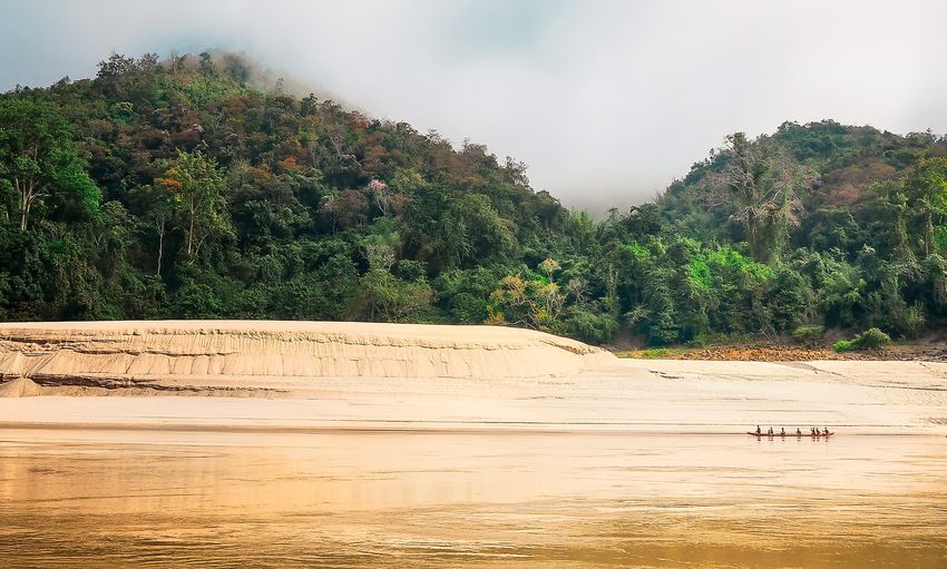
GEO LDN Initiative responds to
UNCCD call to action for SDG 15
Land Degradation Neutrality is defined by the United
Nations Convention to Combat Desertification (UNCCD)
as when “the amount and quality of land resources,
necessary to support ecosystem functions and services
and enhance food security, remains stable or increases
within specified temporal and spatial scales and
ecosystems.”

Countries need quantitative assessments and maps of
degraded land to halt, and eventually reverse, current
trends toward land degradation. The importance of this
Earth observation-based information is recognized in               GEO activities contribute to Goal 14: Life
SDG indicator 15.3.1 (proportion of land that is degraded       below water
over total land area), and by the adoption of Land              GEO activities are contributing the SDG 14 (Life
Degradation Neutrality targets under the auspices of the        below water) in a variety of areas. EO4SDG and GEO
UNCCD.                                                          Blue Planet are working together to measure marine
                                                                pollution. GEO Blue Planet recently contributed to the
In September 2017, the UNCCD 13th Conference of the
                                                                draft Global Manual on Ocean Statistics, produced by
Parties invited GEO to support them in implementing
                                                                UN Environment. At the same time, GEO Aquawatch is
the Convention by providing space-based information
                                                                developing an inventory of eutrophication monitoring
and in situ measurements. In response, UNCCD and GEO
                                                                methods and projects to address needs of UN
partners have developed the GEO Land Degradation
                                                                Environment and the Intergovernmental Oceanographic
Neutrality Initiative (GEO LDN). This Initiative will advance
                                                                Commission (IOC)-UNESCO for SDG 14.
the collaborative development, provision and use of
Earth observation datasets, quality standards, and
analytical tools to achieve Land Degradation Neutrality.
                                                                   Japan’s Forest Early Warning System
The strategic objectives of GEO LDN are to:                     expanded to 77 countries
                                                                As part of their GEO contribution, the Japan International
1) Facilitate access to space-based information and in situ
                                                                Cooperation Agency (JICA) and the Japan Aerospace
   measurements;
                                                                Exploration Agency (JAXA) have launched the ‘Forest
2) Provide expertise, tools and training to build national      Early Warning System in the Tropics (JJ-FAST)’, a web-
   capacities; and                                              based system that uses satellite data to monitor tropical
3) Assist with the further development of international         forests every 1.5 months. In June 2018, the system’s
   standards and protocols for the indicator.                   service coverage was expanded to include 77 countries.

                                                                This system will help countries meet SDG 15 (Life on
                                                                Land) targets related to forests and biodiversity, as
                                                                well as SDG 13 (Climate Action) and articles of the Paris
                                                                Agreement. The Global Forest Observations Initiative
                                                                (GFOI) and its partners are currently considering how the
                                                                system could potentially be used by countries to detect
                                                                illegal logging.

GEO Highlights 2017-2018                                                                                                     4
#EO4PARIS
GEO AND THE PARIS AGREEMENT

    In December 2015, the Parties to the United Nations Framework Convention on Climate Change (UNFCCC)
    agreed to strengthen commitments to address the threat of climate change. Earth observations are
    required to respond to the many specific provisions of the Paris Agreement – including national reporting,
    mitigation measures, adaptation, technology transfer and capacity building.

                 In 2017-18, the recognition of the value of Earth
                 observations for tackling climate change and of GEO’s               GEO holds 1st Paris Climate Workshop
                 role in supporting the global climate agenda continued          In June 2018, GEO’s first workshop on the Paris
                 to expand. This was demonstrated by GEO’s deepened              Agreement marked a significant milestone in GEO’s
                 engagement at the international policy level and through        efforts to engage key organizations with explicit
                 increasing contributions by the GEO community to                mandates in the climate policy process.
                 UNFCCC efforts.
                                                                                 The workshop was attended by over 100 participants,
                                                                                 including representatives of relevant GEO activities,
                                                                                 international organizations and Member Countries.
                    Value of Earth observations for the Paris                    Key speakers from UNFCCC, IPCC, the Global Climate
                 Agreement reaffirmed at COP23                                   Observing System (GCOS), the World Meteorological
                 For the first time, GEO participated as an official exhibitor   Organization (WMO), Committee on Earth Observation
                 and side event organizer at the UN Climate Change               Satellites (CEOS) Coordination Group for Meteorological
                 Conference (COP23) in November 2017.                            Satellites (CGMS) and the World Climate Research
                                                                                 Programme (WCRP) shared their current needs and
                 Together with the Global Climate Observing System               discussed opportunities for GEO to support the
                 (GCOS) and the Remote Sensing Technology Center of              international climate agenda. Concrete action areas
                 Japan (RESTEC), GEO organized an official side event            identified for GEO included:
                 that explored the role of Earth observations to support
                 National Greenhouse Gas (GHG) Inventories and the                 • helping to improve climate data access;
                 ongoing refinement of the Intergovernmental Panel on              • supporting actions on mitigation, adaptation and
                 Climate Change (IPCC) Guidelines.                                   loss and damage;
                                                                                   • integrating climate with SDGs, Sendai Framework
                 During the 47th session of the Subsidiary Body for                  and other Rio Conventions;
                 Scientific and Technological Advice (SBSTA), this issue           • engaging with national stakeholders (e.g. in
                 was formally brought forward and included in the                    National Adaptation Planning);
                 outcome document, which noted the “increasing                     • supporting IPCC processes (2019 Refinement of
                 capability to systematically monitor greenhouse gas                 2006 IPCC Guidelines on National GHG Inventories;
                 concentrations and emissions, through in situ as well as            Sixth Assessment Cycle);
                 satellite observations, and its relevance in support of the       • responding to actions in the GCOS Implementation
                 Paris Agreement.”                                                   Plan; and,
                                                                                   • enhancing the use of climate data records for a
                                                                                     variety of application areas, including drought
                                                                                     monitoring, renewable energy assessments and
                                                                                     health early warning systems.

5
GEO Carbon and GHG Initiative steering committee and secretariat established The GEO Carbon and GHG Initiative (GEO-C) is evolving into an internationally recognized forum to discuss joint activities in the carbon observation space, and to align the various organizational agendas on carbon observations across the atmospheric, oceanic and terrestrial domains. This global endeavour promotes interoperability and fosters integration in the sector of greenhouse gas measurements, carbon stocks and fluxes. GEO-C builds on existing Initiatives and networks to support their continuity and coherence and facilitate their cooperation, in order to obtain a comprehensive, globally coordinated carbon and greenhouse gas observation and analysis system. GEO-C enables the upscaling of regional efforts to the global level, and serves as an important advocate for the use of Earth observations in the fight against climate change. In early 2018 a GEO-C Steering Committee was established to support the implementation of the Paris Agreement. The Committee includes high-level representation from Japan, the European Commission, GCOS, WMO, UNFCCC, CEOS, IPCC and the Integrated Carbon Observation System (ICOS). A Secretariat, hosted by ICOS, has been established to support the work of the Steering Committee, and to undertake important tasks including mapping the carbon observations landscape, and to support planning, outreach and communication efforts. GEO Highlights 2017-2018 6
Copernicus GEO Initiative powers air
    quality alert applications
    The Copernicus Atmosphere Monitoring Service (CAMS)           CAMS information products have also been used in the
    is a GEO Community Activity that provides consistent          development of the airTEXT information service. AirTEXT
    and quality-controlled global information related to air      is a free and independent public service, currently
    pollution and health, solar energy, greenhouse gases          operational in the United Kingdom and Latvia, that
    and climate forcing. CAMS combines observations from          provides three-day air quality alerts and forecasts by SMS
    satellites and from other sources with numerical models       text message, email, voice message, and through its app
    to deliver value added information about atmospheric          twice daily.
    composition and changes globally and, with refined
                                                                  The service provides air quality maps at street-level
    resolution, over Europe.
                                                                  resolution by adding urban-scale dispersion modelling
    In 2017, CAMS helped to expand the coverage of the            on top of CAMS information products, which are available
    Plumes Air Report - a smartphone application and              at lower resolution. Those forecasts include key air
    website which prompts users to adapt their behavior to        pollutants, such as Nitrogen dioxide (NO2), Particulates
    pollution levels - to every city in the world, by providing   or Particulate Matter (PM10) and (PM2.5) and Ozone (O3).
    forecasts of the key air quality pollutants at the global     CAMS information on ultraviolet (UV) radiation, birch and
    scale. At the end of 2017, the Plume Air Report had been      grass pollen is also provided to users.
    downloaded close to half million times, with 73% of users
    saying it has helped them make changes to avoid smog
    spikes in their cities.

7
Copernicus Climate Change Service C3S Monthly Climate Bulletins and CAMS
Climate Data Store launched daily air quality bulletin on Euronews
Europe’s Climate Data Store is a one-stop-shop for past, C3S’s climate bulletin and CAMS air quality forecasts
present and future climate information. have been broadcast monthly and daily (respectively) on
Euronews since December 2017.
Launched by the Copernicus Climate Change Service
(C3S - a GEO Community Activity) in June 2018, the C3S’s Climate Bulletin provides an overview of the
Climate Data Store is an open and free cloud-based climate system over the previous month and continuous
service that allows policy-makers, businesses and monitoring of key climate indicators (e.g. surface air
scientists to browse and combine online petabytes of temperature), while CAMS air quality forecasts provide
raw data, build their own applications, maps and graphs daily information on air quality in the form of the
in real time, and access a wide range of climate datasets European Air Quality index, ranging from 1 (good) to 5
via a searchable catalogue. It greatly improves access to (very bad), and considers forecasted concentrations from
climate data and tools, and is changing the way society the main air pollutants, including ozone, NO2 and fine
can access and benefit from climate science. particulate matter.
Euronews estimates that these programmes have been
“The Climate Data Store gives a wide seen by 18 million viewers during the first quarter of
range of users easy access to good 2018 alone.
quality climate data in one place,
and offers tools that will ultimately
European State of the Climate 2017
lead to better use of the data”
The first European State of the Climate 2017 was
Dick Dee compiled by C3S, CAMS, and the Copernicus Services
Deputy Head of the Copernicus Climate at the European Centre for Medium-Range Weather
Change Service, ECMWF Forecasts (ECMWF). The report covers two main themes:
the climate in 2017 and Headline Climate Indicators.
Available datasets include observations, historical
climate data records, estimates of Essential Climate
Variables derived from Earth observations, global and
regional climate reanalyses of past observations, seasonal
forecasts and climate projections.
The Climate Data Store includes a toolbox that enables
users to analyze, monitor and predict changes in climate
drivers – such as surface temperature and soil moisture
– and their impact on business sectors including energy,
water management or tourism. Users can access these
tools to develop their own applications online.
cds.climate.copernicus.eu
GEO Highlights 2017-2018 8#EO4DRR
GEO AND THE SENDAI FRAMEWORK
FOR DISASTER RISK REDUCTION
The United Nations Sendai Framework for Disaster Risk Reduction commits governments to create and
implement national and local disaster risk reduction strategies. These strategies aim to substantially
reduce the impact of disaster risk and losses in lives, livelihoods, and health and in the economic,
physical, social, cultural, and environmental assets of individuals, businesses, communities and countries.
Open Earth observation data and information are a major component in the reduction of disaster risk.
GEO and Earth observations included in Engagement strengthened with United
Sendai Framework Data Readiness Review Nations Office for Disaster Risk Reduction
Government agencies need a consistent methodology to The development and strengthening of the strategic
use Earth observations in their disaster risk management relationship between GEO and UNISDR has been a key
plans and processes. GEO’s work in support of the focus for the GEO Secretariat over the last year.
Sendai Framework is focused on supporting countries
In addition to the inclusion of language relating to
to incorporate Earth observations into their national
Earth observations and GEO in the Sendai Framework
disaster risk reduction strategies.
Data Readiness Review, UNISDR representatives have
The 2017 United Nations Office for Disaster Risk expressed their Sendai-related requirements from
Reduction (UNISDR) Sendai Framework Data Readiness GEO activities and invited GEO’s Secretariat Director
Review assesses the readiness of countries to to participate on the Global Assessment Report (GAR)
report against the targets of the Sendai Framework. Advisory Board.
Produced with input from the GEO community, the
Published every two years, the GAR is a flagship UNISDR
Review highlights the role that disaster-related Earth
publication that includes a comprehensive review
observations have in the reduction of disaster risk, and
and analysis of disaster risk management globally. The
the value that Earth observation derived monitoring and
Advisory Board sets the direction and content of the
methodologies have within the Sendai Framework.
report, which details the progress made by countries on
the implementation of the Sendai Framework.
“Providing a historical record of changes
to the Earth – such as land use change,
flood, drought and other aspects of
disaster – Earth observations can be
combined with demographic, statistical,
and other data, to support data-driven
decision-making and action across
government institutions
and programmes.”
Sendai Framework Data Readiness Review 2017
9GEO Initiative supports emergency
response during the 2018 Kilauea
eruption, Hawaii
GEO’s Geohazard Supersites and Natural Laboratories
(GSNL) Initiative supports geophysical scientific research
and assessment to reduce risk from geological hazards.
GSNL’s seismic, volcanic and multi-hazard Supersites
provide state of the art scientific information for
geohazard assessment to local stakeholders.
From May to August 2018, the Hawaii GSNL Supersite
made significant contributions to disaster response when
the Kīlauea Volcano experienced a summit collapse and
erupted lava in the populated lower Puna district of the
Island of Hawaii. Over 700 homes were destroyed by
the ensuing lava flow. Although surface deformation,
as revealed by radar interferometry and ground-based
GPS stations, was severe in early May as many eruptive
fissures opened, data provided via GSNL showed no
surface deformation after late May, suggesting that no
new eruptive fissures would form. This was of crucial
importance to the Hawaiian Volcano Observatory, which
was tasked with monitoring the eruption, and Hawaii
County Civil Defense, which is responsible for emergency
response operations.
In the months and years to come, the data collected by
international space agencies and the Hawaiian Volcano
Observatory and partners will be extensively exploited
to better understand the unprecedented eruptive event
at Kīlauea. The results of those studies will be used to
improve assessment of volcanic hazards around the
world.
Cosmo-SkyMed data from Kīlauea Volcano were provided by the Italian Space
Agency to the Hawaii Supersite within hours of acquisition, and were invaluable in
guiding hazard assessment by the Hawaiian Volcano Observatory. Data from the
volcano’s summit caldera on May 5 (left) and June 30 (right) illustrate the dramatic
changes to the landscape which are ongoing at the volcano.
Image: NASA Earth Observatory
GEO Highlights 2017-2018 10GEO contributes to UN Resolution on
Geospatial Information and Services for
Disasters
Earth observation data is readily available at the time
of a crisis through a variety of channels, including the
International Charter Space and Major Disasters, global
platform providers, and through Volunteered Geographic
Information. The accessibility and use of geospatial
information from authoritative sources ensures that
decision makers and other stakeholders get an accurate
common operational picture of critical scenarios before,
during, and after disasters.
GEO worked closely with UN-GGIM and its Member
States to provide input to the UN Resolution on
Geospatial Information and Services for Disasters, which
was adopted by the UN Economic and Social Council
in July 2018. The Resolution guides stakeholders in the AOGEOSS facilitates global data sharing
management of geospatial information and services for disaster response
through better governance and policies, awareness Under the coordination of AOGEOSS, GEO’s regional
raising and capacity building, data management, Initiative in Asia-Oceania, a new mode of international
common infrastructure and services, and resource disaster emergency cooperation is gradually being
mobilization. established. This data sharing for disasters is expected to
become an important supplement for other international
GEO also contributed to the disaster cooperation mechanisms, and has already proven
updated 2018 Strategic Framework valuable in several cases over the last few years.
on Geospatial Information and
Services for Disasters, providing In 2017, over 126 Gigabytes (GB) of data collected
information on Earth observation from eight satellites operated by AOGEOSS countries
requirements and use cases to was shared with Mexico during the Central Mexico
the UN-GGIM Working Group on earthquake to assist with disaster response and recovery.
Disasters, in close collaboration Previously, over 120GB of data was rapidly shared with
with UNISDR. New Zealand, Australia and other countries affected by
the 2017 New Zealand earthquake.
11TARGETED SOLUTIONS WHERE THEY MATTER
NATIONAL AND REGIONAL IMPACT
Early warning for crop failure
enhances livelihood and food
security in Uganda
As the backbone of Uganda’s economy, agricultural Leveraging GEOGLAM’s tools and expertise, Uganda now
employs over 60% of the population and contributes runs a national crop monitor, and publishes its reports
to over 70% of the country’s export earnings. By May as part of the Uganda National Integrated Early Warning
2017 widespread crop failure was evident in Uganda, as System (U-NIEWS) bulletin.
drought caused crop conditions to drop below critical
Without open satellite data, the high cost to collect
thresholds. By August, poor production was confirmed
near-real-time data and information would be a massive
by GEO’s Global Agricultural Monitoring Initiative
barrier to mitigate climate risks in Uganda and other
(GEOGLAM) Crop Monitor for Early Warning.
at-risk countries. Open data and analyses from the GEO
While crop failure can have devastating impacts on community reduces this barrier, by ensuring that all
farmers’ livelihoods and on food security, early warning countries, organizations and individuals have access to
gives governments time to mitigate loss and damage. the data and information they need.
In Uganda, satellite data from the GEOGLAM indicated
As the value of crop monitor systems become clear, with
impeding crop failure and triggered the country’s
success stories from Uganda and beyond, more countries
Disaster Risk Financing fund. This fund provided US$4
are adopting them to mitigate agricultural risk.
million to support 31,386 households (roughly 150,000
people) during the crisis.
“In the past we always reacted to crop *This story was originally published in ‘Satellites and Climate Change:
failure, spending billions of shillings to
Acting Together’ (2018)
provide food aid. 2017 was the first time
we acted proactively because we had
clear evidence from satellite data very
early in the season.”
Martin Owor
Commissioner, Prime Minister of Uganda
This wasn’t the first time early warning proved vital for
Uganda’s capacity to prevent a disaster. In 2013, an Earth
observation-based report led to an immediate decision
to provide food aid. Prior to this, decisions were based on
time-consuming field assessments.
GEO Highlights 2017-2018 12Africa Regional Data Cube lays Kenya’s first national crop monitor set
groundwork for first continental-scale to strengthen food security
access to analysis ready data Kenya’s Ministry of Agriculture, Irrigation, Livestock and
Launched in March 2018, the Africa Regional Data Cube Fisheries has issued the country’s first national crop
is a tool that harnesses the latest Earth observation and monitor, with support from NASA SERVIR, Regional Center
satellite technology to help Kenya, Senegal, Sierra Leone, for Mapping of Resources for Development (RCMRD), and
Ghana, and Tanzania address food security, as well as GEOGLAM. Information on crop conditions from across
issues relating to agriculture, deforestation, and water Kenya was made publically available in the first edition of
access. the crop monitor in May 2018.
The Africa Regional Data Cube was developed by CEOS in
partnership with the Global Partnership for Sustainable
Development Data (GPSDD), GEO, Amazon Web Services,
Strathmore University and the Government of Kenya.
In addition to helping convene and communicate
activities around the Africa Regional Data Cube, GEO is
now working with these partners and others, including
the World Economic Forum, the Government of South
Africa, and the Government of Australia, to scale up this
project to the whole of Africa. The project, Digital Earth
Africa, will improve understanding of Africa’s changing
landscape, providing much-needed insights, knowledge
and analysis ready data (ARD) for more informed,
strategic and inclusive decision-making across the
continent.
13GEO-CRADLE launches Regional Tools for Fourth Regional GEO Initiative launched
Soil Spectroscopy and climate data access in Europe: EuroGEOSS
A Regional Soil Spectral Library (SSL) for North Africa, the Joining GEO’s regional Initiatives AmeriGEOSS, AfriGEOSS
Middle East and the Balkans has been developed as part and AOGEOSS, EuroGEOSS was launched during GEO
of the GEO-CRADLE pilot project ‘Improved Food Security Week 2017 by the European countries, the European
- Water Extremes Management’. Commission and GEO’s European participating
organizations.
Healthy soils provide essential services such as food
production, prevention of land degradation, water EuroGEOSS is the European component of GEOSS, with
quality, and they act as carbon sinks. Monitoring of Copernicus as a major element. It is application-oriented,
soil quality and soil properties is necessary to ensure serving as an umbrella for existing Earth observation
these benefits are realized. One of the most important initiatives and projects. A key element for this regional
technologies used to monitor soils is soil spectroscopy, work is the transition from a data-centric approach to a
which uses the spectral information of soil samples user-driven one.
to derive their properties, including soil degradation,
EuroGEOSS is promoting incubation and scaling-up of the
moisture content, chemistry composition, pedogenesis,
most promising user-oriented Earth observation services
geochemistry, physics, microbiology, mineralogy, mining
and applications at the national and European levels.
and more. The Regional Soil Spectral Library enables
Particular emphasis is placed on tackling the ‘last mile’ of
researchers and decision makers to explore a regional
the innovation process, enabling pre-operational services
soil spectral dataset that contains metadata on the
that can support other GEO Initiatives and Flagships.
soils sampled, their key properties, and their spectral
signature. EuroGEOSS activities target regional, national and local
level government decision-makers, citizens, researchers,
As part of the GEO-CRADLE ‘Adaptation to Climate
scientists and commercial sector companies.
Change’ pilot project, the Data Extraction Application for
Regional Climate (DEAR-Clima) was developed. DEAR-
Clima is an interactive web application tool that visualizes
and provides time series of essential climate variables
and climate indices based on high horizontal resolution
Regional Climate Model (RCM) simulations from the
Coordinated Regional Downscaling Experiment (CORDEX)
research programme. Open, reliable and user friendly
access to future climate change data from high resolution
RCM projections is essential to support decision makers,
stakeholders, intermediary users and end-users for
climate change mitigation and adaptation.
GEO Highlights 2017-2018 14AOGEOSS pilot study assesses impacts GEOARC supports public decision
from changes to the Mekong River Basin making in Asia and beyond
An ongoing AOGEOSS pilot study is using satellite data In 2017, GEOARC published several thematic ‘Global
and in situ measurements to address issues related to Ecosystems and Environment Observation and Analysis
disaster monitoring, climate change and sustainable Annual Reports’ and corresponding data sets. GEOARC’s
development in the Mekong river basin. As part of series of annual reports support public decision making
AOGEOSS efforts to strengthen the regional use of and promote the use of international standards and
planetary data for sustainable development, this methods for data and information sharing.
pilot is demonstrating the value and impact of Earth
The GEOARC report on China’s ‘Belt and Road Initiative
observations in the region.
Ecological and Environment Conditions’ looks at ten
The Mekong river originates from the Tibetan Plateau and terrestrial regions and twelve ocean regions, and
runs through China, Myanmar, Laos, Thailand, Cambodia, provides a comprehensive analysis of the terrestrial
and Viet Nam. Human activities and climate change ecosystems, ecological environment and development
are primary causes of environmental changes in the conditions of critical urban areas, road connectivity
river, with impacts on water management, agriculture, conditions, the status of terrestrial solar energy resources,
flooding, energy, health, biodiversity, environmental land water budgets, and marine disasters in key
pollution and transportation. ocean areas.
As part of the pilot study, AOGEOSS co-lead countries The ‘Impacts of Global Natural Disasters on Vegetation’
Australia, China, Japan, and the Republic of Korea are report evaluates the impacts of major disasters (drought,
working together to share data and technical resources flood, forest fire and earthquake) on terrestrial vegetation
in order to assess the societal impact from changes to over the past 30 years, analyzing spatial distribution
the river system. Satellite remote sensing data is being characteristics, occurrence frequency and influence of all
provided, including low/medium resolution data to cover selected disaster events.
the entire river basin, and high resolution data for specific
Find these and other GEOARC reports at:
areas of interest, including Luang Prabang Province
www.chinageoss.org/geoarc/en
(Lao People’s Democratic Republic), Tonlé Sap Lake
(Cambodia), and the Mekong Delta of Viet Nam.
Findings from this and future case studies conducted
through AOGEOSS will be used to prepare analyses and
action plans that can help address priority issues
in the region.
15BRIDGING GAPS FOR WORLDWIDE IMPACT
COORDINATING GLOBAL OBSERVING SYSTEMS
GEO Wetlands Community Portal Global mercury monitoring for Minamata
now online The Global Observation System for Mercury (GOS4M), a
GEO Wetlands strengthens capabilities for mapping, GEO Flagship Initiative, provides monitoring data and
monitoring and stocktaking of wetlands globally to modelling tools to support the UN Environment Global
support sustainable management of these fragile Partnership on Mercury Fate and Transport Partnership
ecosystems – from local ponds to global governance. and the implementation of the Minamata Convention on
Mercury.
The new GEO Wetlands Community Portal is the pilot for
a global wetland observation system being developed Over the past year, GOS4M has developed a conceptual
in support of the Ramsar Convention on Wetlands and Minamata Convention Knowledge Hub. The Hub
other global frameworks. It builds on developments includes a variety of tools for pre- and post-processing
within the Satellite-based Wetland Observation Service of observational data and modeling outputs. The Hub is
(SWOS) European Union Horizon 2020 project, and will being designed to assist policy makers assess the fate of
become a core part of the forthcoming GEO-Wetlands mercury from emission sources to terrestrial and aquatic
knowledge hub. receptors, and to evaluate the relative contributions of
different natural and anthropogenic sources on total
The portal is designed to support wetland-related
mercury entering terrestrial and aquatic ecosystems. The
decision making at all levels, and to facilitate SDG
Hub is in testing to assess the possible link between past
monitoring and reporting processes. The portal provides
trends in atmospheric deposition fluxes with mercury
guidelines and user stories to highlight the uses of Earth
concentrations found in top predators (i.e., fish, marine
observations for wetland mapping and monitoring. It
mammals and birds). The Knowledge Hub is expected to
contains maps and results from projects, and allows
launch at the end of 2019.
discovery of and access to relevant satellite data.
In September 2017, GOS4M’s director was nominated
by the Presidency of the European Union as one of
five Europeans to serve on an ad-hoc group of experts
established at the first meeting of the Conference of
the Parties to the Minamata Convention. The group will
explore the need for comparable data and establish
an evaluation framework. The group is now exploring
a formal agreement between the GEO and Minamata
Convention Secretariats to formalize GOS4M’s support for
the future activities of the Convention.
GEO Highlights 2017-2018 16Human Planet Initiative products
facilitate urban planning and resilience
GEO’s Human Planet Initiative is working to produce
global, free and open data on human settlements. The
information produced by the Human Planet Initiative
enables analysis of the impact of human activity on
the environment, the impact of natural hazards on
settlements and human society, and the demand for
resources from settlements and society.
By processing satellite imagery to extract built-up
information and combining it with other information -
in particular census data - the Human Planet Initiative
produces knowledge for use by scientists and decision
makers, supports crisis management, urban planning and
resilience.
In its first year, the Human Planet Initiative has produced
the following products:
• Global built-up area spatial grids
(1975, 1990, 2000, 2015)
• Global population density spatial grids
(1975, 1990, 2000, 2015)
• Settlement models that partition the global built-up
areas by settlement type, including cities, suburban
areas, towns, villages and rural areas.
Human Planet Initiative products supported the testing
of the Global Definitions of Cities; a joint initiative
between the European Commission, Organisation for
Economic Co-operation and Development (OECD),
the Food and Agriculture Organization of the United
Nations (FAO) and the World Bank, and have been used
to define the New Degree of Urbanization; an approach
for harmonizing several existing concepts of spatial
population density. The data has also been used to
improve the global strategy for improving agricultural
and rural statistics through joint cooperation with the
European Commission and FAO.
17GEOGLOWS Global Streamflow
Forecasting Pilots
The GEO Global Water Sustainability Initiative Environmental Studies (IDEAM) to visualize water levels
(GEOGLOWS) provides knowledge, data, and products and historical data from their 200+ monitoring stations, in
that help water resource managers around the world order to both assess the ECWMF-based simulations and
make better decisions. By bringing together global more accurately identify areas at risk of flooding.
partners to improve and test much-needed tools and
In Nepal, GEOGLOWS partnered with the national
resources, GEOGLOWS is contributing to global water
Department of Hydrology and Meteorology (DHM) on a
management and disaster risk reduction.
pilot application that increased capacity to identify and
WIthin the framework of GEO, experts from around the forecast flood events and their impact.
world have collaborated on an open global hydrologic
In Bangladesh, the pilot application was developed
information system. This system provides vital
in collaboration with the national Flood Forecasting
information in places where little or none exists, and fills
and Warning Centre and the International Centre for
gaps to strengthen national, regional, and local water
Integrated Mountain Development (ICIMOD), and
management efforts.
was customized to help decision makers forecast
GEOGLOWS partners are leveraging advances in cloud transboundary flows that were used to drive their
computing, physics-based modeling, data sharing national flood warning system.
standards, and data visualization that have enabled
a more holistic Earth system approach to modeling
the hydrologic cycle - addressing a gap that no single
organization has been able to address.
As a result, GEOGLOWS has developed a practical and
technical approach that translates raster information
from ECMWF to forecast streamflow discharge for river
networks around the world.
GEOGLOWS Global Streamflow forecasting pilots - led
by researchers at Brigham Young University - have been
undertaken in the Dominican Republic, Colombia,
Bangladesh and Nepal, in order to assist with the analysis
of past floods, forecasting of future floods and damage, as
well as other water resource uses based on local needs.
In the Dominican Republic, GEOGLOWS worked closely
with the National Institute of Hydraulic Resources
(INDRHI) to create customized applications for
nationally-defined needs in the areas of flood protection,
agricultural demand and reservoir management.
In Colombia, the customized GEOGLOWS application
enables the Institute of Hydrology, Meteorology and
GEO Highlights 2017-2018 18FROM DATA TO KNOWLEDGE
ADVANCING GEOSS
A central part of GEO’s mission is to build the Global Earth Observation System of Systems (GEOSS): a set
of coordinated, independent Earth observation information and processing systems that interact and
provide access to diverse information for a broad range of users in both public and commercial sectors.
GEOSS links these systems to strengthen the monitoring of the state of the Earth.
GEOSS facilitates the sharing of environmental data and
information collected from the large array of observing New resources
systems around the world, and ensures this data is The number of new Earth observation data providers
accessible, quality checked, traceable and interoperable, contributing to the GEOSS Platform has grown
in order to support the development of tools and the significantly each year, and now includes more than
delivery of information services. 180 brokered data catalogues from over 7000 data
providers, and consists of 415 million discoverable
The GEOSS Platform, via the GEOSS Portal, offers a unique Earth observations. In the last year alone, 23 new data
online access point for data, imagery and analytical catalogues have been added to the GEOSS Platform:
software packages relevant to all parts of the globe.
It connects users to existing databases and portals • Copernicus Marine Services
and provides reliable, up-to-date and user-friendly • Copernicus Atmosphere Monitoring Services
information – vital for the work of decision and policy • UNESCO IIWQ EO Map World Water Quality
makers. • UNESCO Water Information Network System (WINS)
• World Resource Institute (WRI) Open data
• World Bank Data Development Hub
• World Bank Global Facility for Disaster Reduction
New and Improved Features and Recovery (ThinkHazard!)
• Climate Change Centre Austria
To better serve Earth observation user communities,
• Sierra Nevada Global Change Observatory
the GEOSS Platform has incorporated several new and
• Sustainable Caucasus Catalogue
customizable instruments and services over the past
• Economic Community of West African States
year. Critical components were implemented to improve • AtlantOS
user experience. A simplified procedure for registering • European Commission Joint Research Centre Water
new data systems has consolidated the resource sharing Data Portal
process, and the service provision for developing • Hydroshare
community applications and portals was improved. • EnviDat
During the registration process, data providers now • FAO GeoNetwork
receive an interoperability test report that assesses their • Dynamic Ecological Information Management
adherence to GEO’s Data Sharing and Management System (DEIMS) Data Integration Portal (DIP)
• EURAC research
Principles.
• World Data Centre for Soils (ISRIC)
• Healthsites.io
• China GEO
• Cyprus GEO PORTAL
• Water-Switch ON
19Users and outreach China and Japan release millions of
The GEOSS Platform team has continued to improve
satellite data resources through GEOSS
outreach efforts with data users and providers across the Over the course of 2017, China progressively opened up
GEO community. The Platform team has strengthened their Earth observations resources through the GEOSS
linkages with GEO Flagships, Initiatives and Community Platform. Initially linking 200,000 metadata resources as
Activities by leveraging new customizable components a precursor to connecting more than 1 million datasets,
that provide data and information resources for specific this data release was achieved in part through the
user communities. The Platform has also integrated Earth open data policy work done by the GEO Secretariat and
observation information products and services generated engagement with international data providers.
by GEO activities, including GOS4M, GEO Wetlands, and
The 2018 opening of the Japanese open data catalogue,
AmeriGEOSS.
with over 40 million open Earth observations resources,
GEOSS is opening up to a wider spectrum of data was another major advance for GEOSS. These resources
providers and users, including decision makers from will be registered to the GEOSS Platform by the end
the public and the commercial sectors. The transition of 2018.
from the former GEOSS Common Infrastructure (CGI)
to a modern GEOSS Platform opened the door for
contributions from a range of technology and knowledge
providers, including IT experts, mobile app developers
and artificial intelligence specialists.
The increase in data in the Platform has coincided with
a higher number of queries from multiple sectors, with
notable increases in users from universities and the
commercial sector. WMO was the Platform’s biggest user
in 2017-2018, via machine-to-machine connections.
3rd GEO Data Providers Workshop drives
forward global technical cooperation on
data for development
The 3rd GEO Data Providers Workshop brought the
GEOSS community together at the ESA headquarters
in Frascati, Italy, to improve the way Earth observation
data is managed, communicated, disseminated and used
through the GEOSS Platform.
Building on previous editions of this event, the 3rd
GEO Data Providers Workshop demonstrated the
strengthening and growth of the GEOSS ecosystem. Since
its launch, the workshop has doubled in size each year.
Over 200 participants from more than 130 organizations,
33 countries, and 5 continents attended the 2018
Workshop.
3rd GEO Data Providers Workshop, ESRIN (ESA), Frascati, Italy / Photo: ESA
GEO Highlights 2017-2018 20You can also read