ARCHITECTING THE ARCGIS PLATFORM: BEST PRACTICES - MARCH 2020 ARCHITECTING THE ARCGIS PLATFORM: BEST PRACTICES - ESRI
←
→
Page content transcription
If your browser does not render page correctly, please read the page content below

Architecting the ArcGIS Platform: Best Practices

MARCH 2020

Architecting the
ArcGIS Platform:
Best Practices
Copyright © 2020 Esri
All rights reserved.
Printed in the United States of America.

The information contained in this document is the exclusive property of Esri. This work is protected under United States copyright law and
other international copyright treaties and conventions. No part of this work may be reproduced or transmitted in any form or by any means,
electronic or mechanical, including photocopying and recording, or by any information storage or retrieval system, except as expressly
permitted in writing by Esri. All requests should be sent to Attention: Contracts and Legal Services Manager, Esri, 380 New York Street,
Redlands, CA 92373-8100 USA.

The information contained in this document is subject to change without notice.

Esri, the Esri globe logo, The Science of Where, ArcGIS, esri.com, and @esri.com are trademarks, service marks, or registered marks of Esri
in the United States, the European Community, or certain other jurisdictions. Other companies and products or services mentioned herein may
be trademarks, service marks, or registered marks of their respective mark owners.
Architecting the ArcGIS Platform: Best Practices

What’s New (March 2020)
This update includes two new best practices (Communicating Success and Geospatial Strategy) as well as an expanded
Security best practice.

Modifications
The Geospatial Strategy best practice has been added. This best practice describes a high-level approach that can help
you develop and execute a business-oriented plan for using GIS. An effective geospatial strategy aligns GIS with the
needs and goals of your organization, so you can deliver solutions that provide demonstrable and measurable
business value.

The Communicating Success best practice has been added. This best practice describes the need for effective
communication when you deliver new GIS solutions as part of a geospatial strategy. It also describes how
communication can help you build stronger internal support for GIS solutions and investments.

The Security best practice has been expanded to include hardening, and the related recommendations have been
revised.

The Conceptual Reference Architecture has been updated to reflect the new best practices.

The remaining best practices were reviewed and remain unchanged in this update.

                                                                                                                           3
Architecting the ArcGIS Platform: Best Practices
Introduction
You can maximize the value of the ArcGIS platform, in the context of your organization’s goals, by applying the guidelines
presented in these best practices and implementation approaches.
Architecting the ArcGIS Platform
The ArcGIS platform connects maps, apps, data, and people in ways that help organizations make more informed and
faster decisions. ArcGIS accomplishes this by making it easy for everyone in an organization to discover, use, make,
and share maps from any device, anywhere, anytime. Furthermore, ArcGIS is designed to be flexible, offering these
capabilities through multiple implementation patterns and approaches. Together, these capabilities and flexible
approaches make it easier for you to extend the reach of GIS across the enterprise.
This document presents some implementation guidelines in the form of a conceptual reference architecture diagram
and associated best practice briefs. You can use these guidelines to maximize the value of your ArcGIS
implementation and meet your organizational objectives.
Conceptual Reference Architecture
The ArcGIS Platform Conceptual Reference Architecture diagram
(found on page 6) illustrates platform capabilities combined with
best practices and patterns of business use.
The diagram depicts three distinct computing environments—
production, staging, and development—which together represent a
best practice known as environment isolation. Each environment has
four components, with each section displayed in a different color to
highlight the function. Figure 1 identifies those components by color
and number.
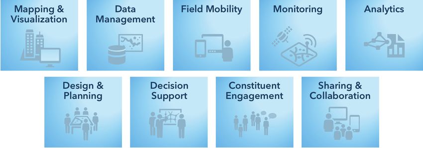
The Apps section illustrates the components of the platform that
most users interact with, including end-user applications such as
ArcGIS Pro, Collector for ArcGIS, Story Maps, and Operations
Dashboard for ArcGIS. Apps connect people and their business
workflows to the platform. Apps are typically used in workflows that
follow one or more of the patterns of use (mapping & visualization,
data management, field mobility, monitoring, analytics, design &
planning, decision support, constituent engagement, and sharing &
collaboration). For example, the sharing & collaboration pattern
extends geospatial capabilities to everyone in the organization by
providing a destination (website and simple apps) where knowledge Figure 1: Components of the ArcGIS Platform
workers, executives, and field workers can discover, use, make, and Conceptual Reference Architecture: 1, Apps (orange);
share maps. A person capturing data in the field with Collector for 2, Portal (green); 3, Infrastructure (blue); and 4,
ArcGIS is following the field mobility pattern. A decision-maker using External Systems and Services (purple).
Operations Dashboard to observe the real-time information created
by field workers is following the decision support pattern.
The Portal component of the platform organizes users and connects them with the appropriate content and
capabilities based on their role and privileges within the platform. The portal uses a person’s identity to deliver the
right content to the right person at the right time. From a product perspective, the portal is either ArcGIS Enterprise
(software) or ArcGIS Online (Software as a Service, or SaaS). The portal provides access controls, content
management capabilities, and a sharing model that enables users to share information products across the
organization.
4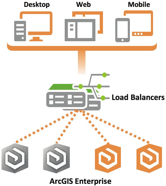
Architecting the ArcGIS Platform: Best Practices

The Infrastructure component includes the hardware, software, services, and data repositories that are the core of
the ArcGIS platform. Numerous best practices—including load balancing, high availability, workload separation, and
publication strategies—are linked from and associated with the platform infrastructure. Follow the links from each
best practice label on the Conceptual Reference Architecture diagram to learn more about how these strategies affect
infrastructure decisions. Additional information is also available in the Infrastructure best practice brief.

The External Systems and Services components include other systems that either provide services to ArcGIS or
consume ArcGIS services to geospatially enable their capabilities. The ability to easily geoenable other enterprise
business systems is a key capability of ArcGIS.

Best Practices
There are 20 best practice briefs associated with the ArcGIS Platform Conceptual Reference Architecture diagram.

Eleven of these briefs—Automation, Distributed Web GIS, Enterprise Integration, Environment Isolation, High
Availability, Infrastructure, Load Balancing, Publication Strategy, Real-time GIS Strategy, Security, and Workload
Separation—reference technology practices that provide high-level implementation guidelines based on business
needs. Following these best practices will help organizations meet requirements for performance, security, and
availability.

The best practice briefs for Application Implementation Strategy, Capability Delivery, Communicating Success,
Geospatial Strategy, Managing Identities, Patterns of Use, Prioritization Approach, and Workforce Development focus
on people and how they should interact with ArcGIS.

Finally, the Governance brief offers a complementary process guideline that suggests ways to minimize risk, improve
quality, and increase productivity around ArcGIS solutions.

How to Use This Document
The ArcGIS Platform Conceptual Reference Architecture diagram is a clickable graphic that contains links to each best
practice brief. You can use the diagram to explore how the individual briefs relate to the platform, or to visualize how
the ArcGIS platform will support organizational business needs.

Comments and Suggestions
Any comments or suggestions regarding this document can be emailed to SA@esri.com.

                                                                                                                             5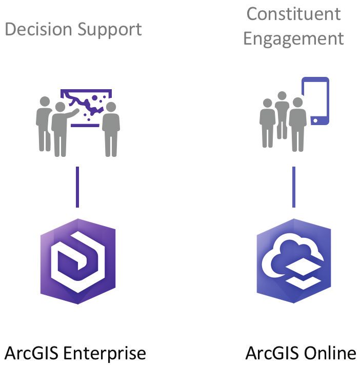
ArcGIS Platform Conceptual
         Reference Architecture
                                           Mapping &                         Data
                                                                                                   Field Mobility                       Monitoring                                             Analytics
       SDKs / APIs

                                           Visualization                  Management
APPS

                                                                                                       Solutions
                                                                Design &                    Decision               Constituent                                               Sharing &
                                                                Planning                    Support               Engagement                                                Collaboration
                                                                                                Patterns of Use

                                                                 P O R TA L
                                                                  SDKs / APIs

                                          Users • Groups • Items • Tags
                                                            (Content and Capabilities)

                                                                                                                                           EXTERNAL SYSTEMS AND SERVICES
                                   Web Maps                 Web Layers              Tools         Files
                                                                                                                                                                                         Enterprise
                                                                                                                                                                                         Systems
                                                                                                                                                                                         • CRM
                                                                                                                                                                                         • EAM
                                                  INFRASTRUCTURE
                                                                                                                                                                                         • BI
                                                                  SDKs / APIs                                                                                              SDKs / APIs   • Microsoft Office
                                                  W O R K LOA D S E PA R AT I O N
                                                                                             Management
                                            Visualization

                                                                                                                                                                                         Other
                                                                         Analysis
          H I G H AVA I L A B I L I T Y

                                                                                                              LOA D B A L A N C I N G

                                                                                                                                                                                         • Social
                                                                                                Data

                                                                                                                                                                                         • Weather
                                                                                                                                                                                         • Traffic
                                                                                                                                                                                         • Real-time Feeds
                                                                                                                                                                                         • IoT Sensors

                                                     Data and Storage

PRODUC TION                                                         S TAG I N G                                              D E V E LO P M E N T

                                                                    A SSO C I AT E D B E S T PR AC T I C E S

                          Automation • Capability Delivery • Communicating Success
                          Geospatial Strategy • Governance • Prioritization Approach
                           Publication Strategy • Security • Workforce Development
                                                                                                                                        Copyright © 2020 Esri. All rights reserved.
                                                                                                                                                                       March 2020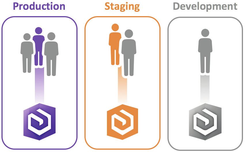
Architecting the ArcGIS Platform: Best Practices

Application Implementation Strategy
An application implementation strategy is an approach to delivering capabilities that meet your business needs with
technology. An ideal strategy will minimize cost and optimize the use of development resources. By applying a “configure
first” philosophy that prioritizes commercial off-the-shelf (COTS) apps and least-effort design patterns, you can reduce
the cost and effort needed to deploy and maintain applications for your users.

A Flexible Platform for Implementing Location-Enabled Apps
ArcGIS is a platform for applying the power of geography to improve workflows throughout an organization. Apps
provide the user experience that makes ArcGIS capabilities available at the right time on the right device, so users can
work more efficiently. Implementing apps, however, can require different approaches, depending on whether the
capabilities you need are available out of the box. ArcGIS helps you deliver these capabilities by supporting multiple
approaches to application implementation (as shown in figure 2), while also helping you minimize cost and effort.

There are many factors to consider when deciding the best way to deliver new
capabilities through apps. These factors include resourcing, initial development
effort, ongoing app maintenance, user training, and technical support. In addition,
users now expect frequent updates to their apps, which increases demand for
resources to develop and maintain custom apps. As a result, it’s best to select the
approach that delivers the capabilities you need with the least cost and effort.

Depending on your specific requirements, you can:

    1. Configure COTS apps to meet your business needs. ArcGIS provides many             Figure 2: Configure first for the
       configurable COTS apps that support key workflows out of the box. Using           lowest cost and least effort, then
       COTS apps requires the least effort and the lowest ongoing cost.                  extend and customize as needed.

    2. Extend existing apps, either by modifying templates or by creating widgets for COTS apps. Esri offers app
       templates at arcgis.com and github.com/esri that provide focused solutions for specific problems; you can
       modify the source code for these templates to add discrete capabilities. In addition, several ArcGIS COTS apps
       use modular frameworks that let you create custom widgets and plug them into the apps. Extending existing
       apps lets you develop only the additional functionality you need, saving money and effort.

    3. Customize apps using ArcGIS APIs and SDKs. These APIs and SDKs provide objects like the Identity Manager
       to manage credentials within custom apps that expose parts of the ArcGIS platform (such as secure web
       maps). Because you don’t have to code those parts yourself, you can build business-focused apps to take
       advantage of ArcGIS COTS capabilities, reducing the overhead for app development and maintenance.

A configure-first philosophy helps you avoid unnecessary cost and effort associated with custom app development,
maintenance, and training. Organizations that adopt a configure-first philosophy start by configuring COTS apps, then
extend and customize apps only when needed. Using this least-effort approach in your application implementation
strategy lets you deliver capabilities faster and reserve your development resources for more complex tasks.

Recommendations
To establish an effective application implementation strategy for your organization:

    1. Adopt a configure-first philosophy, configuring COTS apps when possible to deliver the capabilities you need.

    2. If you have a requirement that cannot be met with configuration alone, extend existing apps with discrete
       capabilities and widgets.

    3. When you need capabilities that you can’t provide by configuring and extending existing apps, customize
       apps using ArcGIS APIs and SDKs.

                                              Back to Reference Architecture                                                  7
Architecting the ArcGIS Platform: Best Practices

Automation
Automation is the orchestration of tasks, processes, and compute resources to function automatically and efficiently.
Automation allows you to streamline administrative workflows and repetitive tasks to improve efficiency, consistency,
and productivity, reducing risk and increasing the value of your GIS.

Increasing the Value of ArcGIS Through Automation
Repetitive tasks are common when using GIS to support data
                                                                         Automation Tames the Internet of Things (IoT)
management, analysis, map production, and infrastructure
deployment and operations. Repetitive manual tasks take a lot of         As the volume and velocity of IoT data increases,
time, effort, and focus; decrease overall productivity; and              automation becomes both more necessary and
increase risk. These impacts are compounded as the number of             more valuable to the business.
tasks grows.
                                                                         Working manually, staff often struggle with
You can mitigate these impacts through automation. Automation            processing the high volumes of data produced
allows technology to create and maintain infrastructure and              by IoT devices and scaling infrastructure
programmatically execute the steps of a well-defined workflow            accordingly. This delays the transformation of
while limiting human interaction. Common tools for automation            data into insight, which in turn reduces the
include APIs and scripts.                                                organization’s efficiency and makes its decisions
                                                                         less responsive and less effective.
Automation maximizes your investment in ArcGIS by improving:
                                                                         With automation, you can process IoT data
    1. Efficiency. Information is most useful to the decision-           efficiently, consistently, and routinely. For
       making process when it is delivered in a timely manner.           example, you can automatically allocate
       Because automating tasks and resource allocation                  compute resources to your infrastructure to
       improves efficiency, work can be completed faster and             scale up and down as data volume and
       new information can be delivered to stakeholders                  processing needs fluctuate. This keeps IoT data
       sooner. This boost in efficiency allows ArcGIS to return          flowing to key workflows and business systems,
       greater value to the business.                                    improving efficiency and supporting better,
                                                                         faster decisions.
    2. Consistency. When tasks are executed manually, errors
       are more common and outcomes can be inconsistent, unreliable, and costly. Once developed and properly
       tested, automated processes are highly dependable and can be replicated with identical and predictable
       results. Automated processes save time, minimize duplicated efforts, and increase confidence in business
       operations.

    3. Productivity. Automation can improve all areas of a GIS including deployment, administration, and end-user
       workflows. By using automation to execute more GIS tasks and complete them faster, you can increase
       overall productivity. This lets you apply ArcGIS to additional business initiatives (such as strategic projects,
       research and development efforts, and other high-value projects) that might otherwise go unfulfilled.

With automation, you can improve administrative workflows and process data more efficiently, consistently, and
routinely. This improves operational efficiency and the effectiveness and timeliness of decision-making, freeing
resources for other tasks and boosting the value of ArcGIS in your organization.

Recommendations
To maximize the benefits of automation and reduce risk in your organization:

    1. Automate tasks where human error can impact reliability and consistency in outcomes.

    2. Automate lengthy tasks so processes can be completed in less time.

    3. Schedule automated tasks so they run continuously within set time windows, without human interaction.

                                              Back to Reference Architecture                                                  8
Architecting the ArcGIS Platform: Best Practices

Capability Delivery
Delivering capabilities that support key requirements, goals, and initiatives helps you improve business outcomes. By
working with stakeholders to define the capabilities you deliver, you can better align your solutions with real business
needs. In addition, establishing a regular cadence for capability delivery lets you continuously improve your maps, apps,
services, and information products, so they can provide additional value and meet evolving requirements.

A Business-First Approach to Delivering New Capabilities
Delivering capabilities that support your business requires smart resource investments. Organizations that spend
years on expensive, complex development projects often end up with solutions that are difficult to use or that don’t
align with current requirements. To maximize the value of your investments and better support the evolving demands
of your business, you can work with stakeholders to identify areas where you can provide the most value in the least
time. This business-first approach helps you establish a cadence for rapidly delivering high-impact capabilities and
information products that meet business needs.

For effective capability delivery, you should:

    1. Collaborate with business stakeholders to
       envision their capability needs. Engaging
       stakeholders early in the planning process
       helps you identify the business value a
       capability will provide, balance value against
       risk, and set development priorities. You
       can then apply a configure-first approach,
       deploying low-effort capabilities first. This
       delivers value quickly and builds toward
       long-term success. Once you have a final
       product, you can invite stakeholders to test Figure 3: Capability delivery follows a cadence and terminates when the
       it and offer feedback.                         solution no longer provides value to the business.

    2. Iterate rapidly on existing solutions so you can deliver new value quickly and often. By focusing on
       incremental enhancements that provide clear value, you can avoid spending development time on
       functionality that adds unnecessary complexity. A rapid release cycle should be 30 days or less, with each
       iteration producing a usable deliverable. To meet this short release schedule, you can keep requirements
       simple and focused, and leverage COTS and configurable solutions when possible. With each new release,
       you can solicit stakeholder feedback to drive the next iteration.

    3. Adhere to a capability delivery lifecycle with a regular cadence, like the lifecycle shown in figure 3. This helps
       you continue iterating on your solutions as long as the business gains new value from each iteration. Once
       you satisfy your stakeholders’ needs, you can suspend further iterations, then resume them if future business
       needs require additional enhancements. When a solution no longer provides value, its lifecycle is complete.
       Deprecating these legacy solutions lets you avoid consuming resources unnecessarily.

Recommendations
To deliver capabilities that maximize business value and make effective use of development resources:

    1. Collaborate with business stakeholders to define, prioritize, and test new capabilities.

    2. Keep iteration cycles short and focus on supplying incremental business value with each new release.

    3. Establish a regular cadence for new iterations until you satisfy all identified business needs, and deprecate
       solutions that no longer provide value.

                                                 Back to Reference Architecture                                                 9
Architecting the ArcGIS Platform: Best Practices

Communicating Success
Communicating successful outcomes motivates and incentivizes people in your organization to support GIS. By
reinforcing the business value of GIS, you can build stakeholder support and encourage people to build new GIS
capabilities that solve business problems and help the organization achieve its goals.

Communication: One Action, Three Outcomes
Communication is key to building and sustaining GIS investments. Organizations recognize the need for effective
communication when they are defining their geospatial strategy, but often they don’t realize that communication is
equally important when they are executing that strategy.

After you deliver a geospatial solution that solves a business problem, you should communicate your success with
stakeholders throughout the organization. Doing so produces three positive outcomes:

    1. Awareness: Good communication informs stakeholders that real business value was created from their
       investment in GIS. Without communication, stakeholders may not know that GIS is providing value to their
       business processes. They may not understand how GIS is contributing through spatial analysis, mobile
       workflows, decision support, or information sharing. They may see expenditures without realizing the
       benefits. By publicizing your success to stakeholders, you can help them better understand the power of
       geospatial technology and make them aware of the value it’s providing. This is crucial for GIS to be seen as a
       good investment that helps the organization meet its goals.

    2. Incentive: Good communication encourages other people in the organization to think about how GIS can
       help them. When people can see what is possible with GIS, they are more likely to want to participate in new
       GIS projects. This builds demand and expands the pool of resources that can use GIS. As a result, you can
       leverage your GIS technology investments more fully to deliver the most value possible to the organization.

    3. Acknowledgment: Good communication celebrates and motivates the people that deliver geospatial
       solutions for the organization. Timely and authentic employee recognition builds trust and helps you foster a
       positive culture. In turn, this helps you encourage the people responsible for building solutions, so you can
       continue to deepen the value of geospatial technology to the organization.

Together, these outcomes will help you sustain your GIS program, advocate for additional resources, and increase
your impact.

Recommendations
After you deliver a new solution, you should:

    1. Communicate your success in order to promote greater awareness of GIS, incentivize potential users, and
       acknowledge the hard work of your teams.

    2. Communicate the business impact of your success by highlighting new workflows that save time, reduce
       costs, or improve effectiveness; by showing how business units are using GIS to work together or improve
       their operations in tangible ways; and by illustrating more informed decision-making thanks to geospatial
       technology.

                                                Back to Reference Architecture                                                10
Architecting the ArcGIS Platform: Best Practices
Distributed Web GIS
A distributed web GIS is an integrated set of GIS deployments working together and sharing content as part of a trusted
collaboration. By implementing a distributed web GIS, you can more effectively leverage authoritative data, foster
engagement and communication, and glean insights from data. A distributed web GIS lets you preserve departmental
control over data and workflows while contributing to and supporting the needs of the entire organization.
A Modern Approach to Sharing Information
Distributed web GIS is a modern implementation pattern that supports a new
type of sharing. It allows you to connect multiple GIS deployments together,
so users from each deployment can share content with each other. With this
integrated approach, each department controls access and the level of detail
in shared items, but shares content as needed to support the broader business
needs of the organization. The result is a truly collaborative environment—an
integrated set of deployments working toward shared goals.
For example, an organization might have multiple business units, each with its
own GIS deployment and supporting different business functions. In a city, the
police department, fire department, public works department, and municipal
water utility might each deploy their own GIS to support their individual
workflows. With distributed web GIS, you can connect those deployments so
people across departments or outside the organization can work together
using authoritative data. Figure 4 illustrates these relationships.
Distributed web GIS expands a modern GIS by making its capabilities and data
Figure 4: Preserve control and access
easier to access across the enterprise. A distributed web GIS creates an within individual departments while
organizational network where content can be shared in a simple and supporting the broader needs of the
controlled manner. This enables business units to share select information enterprise and cross-departmental
with the broader enterprise while maintaining control of sensitive data. workflows.
To implement a distributed web GIS, you can use simple out-of-the-box tools available with ArcGIS to create a
distributed collaboration. You can invite multiple ArcGIS Enterprise deployments and (optionally) an ArcGIS Online
organization to the collaboration, and then share data and content with the participants. No custom coding or special
permissions are required.
Each GIS deployment within a collaboration maintains its own maps, apps, and data, continuing to deliver the
capabilities needed for that particular business unit or function. Each participating GIS deployment chooses which
data and content to share with members of the collaboration; updates can be shared either in real time or at
scheduled intervals. Importantly, a collaboration uses each GIS deployment’s existing security model.
With distributed web GIS, you can help multiple GIS deployments support and achieve larger organizational goals
through distributed collaborations, well-defined sharing processes, and automation, all within ArcGIS.
Recommendations
To fully leverage distributed web GIS within your own organization:
1. Model your distributed web GIS after your organization’s structure.
2. If you have departments or business units that need to control sensitive data, allow each to work in its own
GIS deployment as part of a trusted collaboration.
3. Establish distributed collaborations between GIS deployments based on business need, enabling the right
people to have access to the authoritative content they need.
Back to Reference Architecture 11Architecting the ArcGIS Platform: Best Practices
Enterprise Integration: Application Patterns
Application integration patterns describe different approaches to incorporating location intelligence into applications.
You can use these patterns to identify how users will interact with geospatial content, and how capabilities from GIS and
other business systems should integrate.
Patterns for Integrating GIS with Business Applications
Application integration lets you deliver solutions that
combine data and tools from disparate systems—including
your GIS as well as business systems like permitting,
licensing, and asset management systems. With integrated
solutions, you can improve cross-functional business
processes and provide decision-makers with integrated views
of your organization’s information.
How you integrate GIS with other systems will depend on
which system you use as the hosting framework. ArcGIS
helps you meet varying integration needs by supporting
multiple application integration patterns (as shown in figure
5). These patterns include: Figure 5: Application integration patterns for the ArcGIS
platform.
1. Geocentric applications, which enhance GIS
applications with business data and capabilities to automate or inform location-centric activities. Geocentric
applications are dominated by geospatial content and capabilities, while delivering business content and
capabilities secondarily. This pattern typically uses a GIS application as the hosting framework. It is best
suited for staff who are familiar with GIS applications, for situations where GIS activities are central, or for
cases where a user-friendly GIS template or configurable app provides most of the needed functionality.
2. Geoenabled applications, which enhance business applications with GIS data and capabilities to automate or
inform business activities. Geoenabled applications are dominated by business system content and
capabilities that are supplemented by GIS capabilities. This pattern typically uses the business system as the
hosting framework. It is best suited for staff who are familiar with the business system that automates the
related workflows, or when an extensible business system provides most of the needed functionality.
3. Composite applications, which integrate capabilities from multiple systems in situations where no existing
system can or should serve as the hosting framework. This pattern typically uses web services to integrate
data and logic from multiple systems to derive new functionality. Composite applications are conceptually
comparable to mashups, and they represent a contemporary trend in enterprise application development.
No single application integration pattern fits all situations. You can use the application pattern that best combines
capabilities from ArcGIS and your business system to deliver the greatest impact.
Recommendations
The following guidelines can help you determine which application integration pattern best suits your situation:
1. If most of the capabilities you need are delivered by your GIS, deploy a geocentric application.
2. When you need to access GIS content and capabilities within a business system or application, deploy a
geoenabled application.
3. When you need a discrete application that integrates content and capabilities from both your GIS and
existing business systems, build a composite application.
Back to Reference Architecture 12Architecting the ArcGIS Platform: Best Practices
Environment Isolation
Isolating computing environments is an approach to maintaining system reliability and availability. This approach
involves creating separate systems for production, testing, and development activities. Environment isolation reduces
risk and protects operational systems from unintentional changes that negatively impact the business.
Deploying Isolated Environments to Safeguard Operational Systems
Unintentional system changes can cause operational systems to fail to deliver the capabilities and performance that
users expect. Environment isolation insulates different computing environments from the risk of unmanaged change,
helping you better maintain their functionality, stability, and performance.
Users within your organization have expectations for system reliability. In some cases, your users’ expectations may
be documented in a Service Level Agreement (SLA), a contract between business stakeholders and technology service
providers that defines the level of reliability expected by stakeholders. You should consider your users’ expectations
when you decide on the level of environment isolation and governance required to manage system changes.
To effectively manage enterprise systems and meet expectations for system reliability, organizations typically
implement at least three isolated computing environments (as shown in figure 6):
1. A production environment is the live system that supports
end users. Uptime requirements are defined by an SLA and
met through effective change management and
governance. Software, application, configuration, or
network changes should never be made to a production
system without being tested in a staging environment.
2. A staging environment is a mirror of the production
environment that lets you vet system changes before
deploying those changes to production. You can perform
user acceptance testing, performance testing, load testing,
and training in a staging environment to avoid risk to your Figure 6: Recommended (minimum) compute
production system. If needed, you can even implement environments.
multiple staging environments for different testing and
training activities.
3. A development environment is a workspace where developers and analysts can manage content and make
changes without impacting a large audience. This dedicated server environment is typically used for unit
testing, constructing business workflows, or creating new capabilities such as applications, services, data
models, or geoprocessing models. The size and complexity of the environment will depend on the level of risk
generated by changes, the number of creators, and the potential impact of system outages and downtime.
Implementing these isolated computing environments helps you deliver a stable, extensible, and high-performing
system. By leveraging these environments to support effective change management, you can shield your system from
unexpected failure and avoid disruptions to business operations.
Recommendations
To best maintain system reliability and availability for your users:
1. At a minimum, implement isolated production, staging, and development environments.
2. Test system changes in a staging environment before making changes to the production environment.
3. Use a development environment to develop new capabilities without impacting users in other environments.
Back to Reference Architecture 13Architecting the ArcGIS Platform: Best Practices
Geospatial Strategy
A geospatial strategy is a business-oriented plan that defines how an organization will align GIS to support its business.
Organizations that develop and execute a geospatial strategy are able to connect and align technology to their business,
deliver quick value based on priorities, and define and implement sustainable solutions that solve business challenges.
A Business-First Approach for Maximizing the Impact of GIS
Many successful organizations maximize the impact of GIS in their
business by developing and executing a geospatial strategy. A
geospatial strategy gives organizations a way to align their geospatial
capabilities and technologies to their underlying business needs. By
executing on this business-first strategy, organizations can use GIS to
reach their goals and improve outcomes throughout the business.
Employing a geospatial strategy requires a passionate team of leaders
that want to solve business challenges within their organization and Figure 7: A four-phase approach to a geospatial
strategy.
improve the way their organization works. Successful teams include a
champion that believes in the value of geospatial solutions, an executive sponsor that provides resources and
funding, and a technical sponsor that provides resources to implement and maintain sustainable solutions.
With this team in place, you can develop and execute a geospatial strategy, following a four-phase approach that
includes the Understand, Plan, Act, and Revisit phases (as illustrated above):
1. In the Understand phase, the team engages with stakeholders across the organization including
departmental and functional area executives, key business unit directors, and GIS users and managers.
Through these meetings, the team learns what is driving these stakeholders and develops a shared
understanding of the organization, its goals, and its challenges. The outcome of the Understand phase is clear
and shared knowledge of the organization including its mission, goals, business challenges, and more.
2. In the Plan phase, the team documents the current state and defines the future state that will allow the
organization to overcome its challenges and meet its goals. By comparing the current and future states, the
team can define the technology, data, workflows, and skills necessary to establish sustainable solutions that
address business needs. This phase concludes with a road map, a prioritized and sequenced set of activities.
3. In the Act phase, the team executes a series of implementation cycles consisting of activities defined in the
road map. Each implementation cycle should result in one or more tangible outcomes.
4. In the Revisit phase, the team adapts and updates the plan as leadership goals change, business priorities
shift, and technology evolves. The plan should be revisited regularly—especially after each implementation
cycle—to ensure it is maximizing the impact of GIS on the organization.
This approach supports an incremental implementation guided by a geospatial strategy. It allows the team to develop
and execute a plan that aligns geospatial technology to the needs of the business and delivers continuous value.
Recommendations
1. Form a team that includes a motivated champion, an executive sponsor, and a technical sponsor.
2. Develop and execute your geospatial strategy by engaging stakeholders across your organization, defining
business goals and challenges, developing a plan that addresses the needs of the business, implementing
solutions through an incremental process, and revisiting your plan over time.
3. Leverage the best practices contained in this document to maximize the impact of your geospatial strategy
and GIS within your organization.
Back to Reference Architecture 14Architecting the ArcGIS Platform: Best Practices
Governance: Leverage the IT Framework
Information technology (IT) governance is a subset of corporate governance, focused on maintaining IT systems,
maximizing their positive impact, and managing risk to business operations. IT governance helps organizations effectively
build and manage IT solutions. By applying IT governance to the ArcGIS platform, you can deliver clear benefits and
achieve long-term success with your ArcGIS solutions.
Key Components of Effective IT Governance
IT governance is a framework, culture, and set of owned responsibilities that ensure the integrity and effectiveness of
an organization’s use of IT. Organizations implement IT governance by monitoring, managing, and steering their IT
landscape to achieve required business outcomes. Since GIS is part of the IT landscape, IT governance should also be
applied to GIS. Doing so lets you maximize the benefits of deploying and using the ArcGIS platform.
Key areas where IT governance can improve your use of GIS include:
1. Software change management. A software change management plan lets you mitigate operational risk when
implementing new software. An effective plan covers both software testing and the upgrade process. As part
of your plan, you should run functional, performance, and user acceptance tests in a staging environment.
This helps maintain business continuity for production workflows. Once testing shows that the software
works as expected, schedule an upgrade to the production system in advance. This lets you ensure that
essential staff are available and have the privileges needed to perform the upgrade. In addition, document
the upgrade process and establish a rollback strategy, so you can recover more easily if issues occur.
2. Data governance. A data governance approach involves exercising control over data quality, accessibility,
usability, and security. You can integrate spatial data in your broader data governance approach, rather than
treating spatial data as a separate concern. With an integrated data governance approach, spatial data is
maintained by data stewards within your business units and delivered to end users through centrally
managed web services (for example, through distributed web GIS). Data stewards are responsible for data
quality and usability, while IT staff manage data accessibility and security. By managing and serving spatial
data in this way, you can provide useful, high-quality data resources to anyone that needs them. This helps
people more easily access, use, and share maps and data that support their work.
3. Technology alignment. By aligning technology to your business needs, you can help the organization
overcome challenges that impede its mission and goals. To identify these challenges, speak with business
leaders and decision-makers to get a clear picture of their organizational initiatives, goals, and pain points.
Explore ways that GIS can help them complete their objectives and alleviate their challenges. By providing GIS
solutions that support key organizational goals, you can amplify the value your GIS and your team provide to
the enterprise.
By extending IT governance across the GIS domain, you can implement new GIS software more effectively, access and
share useful GIS data across the organization, and increase the value of your GIS program. This improved governance
helps you increase your long-term success with ArcGIS.
Recommendations
To effectively apply IT governance to ArcGIS within your organization:
1. Implement a software change management plan to mitigate the risk associated with upgrading your GIS.
2. Incorporate GIS data in your broader data governance approach, so anyone can access useful, high-quality
maps and data in their work.
3. Align technology to overcome business challenges and amplify the value of your GIS.
Back to Reference Architecture 15Architecting the ArcGIS Platform: Best Practices
High Availability
High availability is a design approach that helps a system meet a prearranged level of operational performance over a
specific period of time. 1 Highly available systems provide customers with a reliable, high-performing environment that
meets or exceeds their business requirements for service delivery.
Strategies for Maximizing System Performance and Reliability
High availability is a set of strategies for minimizing service downtime and maximizing system performance and
reliability. Because GIS is part of critical business operations and workflows, it is essential for organizations to apply
high availability strategies to GIS. By using high availability designs for their ArcGIS deployments, IT managers and
system architects can mitigate the risk of system and component failures.
Before designing a solution for high availability, it is necessary to determine your organization’s acceptable level of
system downtime. This information is typically described in a Service Level Agreement (SLA). An SLA quantifies the
percentage of required service uptime (also known as the “number of nines”). For example, an organization may want
their systems to be available at a rate of 99.9% (three nines), which equates to 8.76 hours of downtime annually or
10.1 minutes weekly. Your SLA will define the amount of uptime your high-availability design must support.
To maximize your system’s performance and uptime, you should:
1. Reduce single points of failure through duplication and load balancing (as
shown in figure 7). Duplication involves implementing multiple instances of a
specific system component. Load balancing is a technique for distributing
client workload traffic requests across multiple system components.
2. Develop and execute test plans to evaluate the system’s ability to meet a
prearranged level of operational performance. These plans should include,
but not be limited to, stress, performance, and failover functions and
activities. At least one test plan should be developed and executed before
going live. All testing plans and associated activities should be part of your
overall system governance.
3. Monitor the health of the system and have a plan in place to correct
problems before they cause a widespread or unrecoverable outage. A variety Figure 8: Duplication and load
of system monitoring tools are available from Esri and third-party vendors. balancing for high availability with
ArcGIS.
By designing your ArcGIS implementation for high availability, you can improve performance and reliability, meet your
SLA commitments, and satisfy your users’ expectations for service availability.
Recommendations
To implement a high-availability design for ArcGIS:
1. Use duplication and load balancing to reduce the number of single points of failure.
2. Test the system regularly to assure that it can meet performance requirements.
3. Monitor your system to catch issues early, and have a plan in place to address issues quickly when they arise.
1
High Availability (HA), while related to Disaster Recovery (DR), is a separate concept. Generally, HA is focused on avoiding downtime for
service delivery, whereas DR is focused on retaining the data and resources needed to restore a system to a previous acceptable state
after a disaster. When DR plans are executed, it is typical for service delivery to be disrupted until the system has been restored.
Back to Reference Architecture 16Architecting the ArcGIS Platform: Best Practices
Infrastructure
GIS infrastructure is GIS technology deployed on standard IT infrastructure components. The server-side infrastructure
components of the ArcGIS platform let you deliver, access, and use data and capabilities wherever and whenever they’re
needed.
An Infrastructure for Serving Data and Capabilities to Users
ArcGIS platform capabilities are delivered by server-side infrastructure components,
represented conceptually in figure 8 and described below. You can host these
components on premises or in a cloud environment like Amazon Web Services or
Microsoft Azure. By leveraging these components, you can expose GIS content and
capabilities as web services and consume those services in your apps. This enables
users to access and apply useful GIS resources in their work.
SDKs/APIs let developers build custom capabilities for specific needs. At the
infrastructure level, they reference objects and interfaces for your GIS servers,
allowing you to extend, consume, and manage GIS services. For example, you can use
ArcGIS Enterprise SDKs to add new operations to map services and extend the
functionality of ArcGIS. In addition, with Esri’s other SDKs and APIs, many client and
server technologies can be integrated with the ArcGIS platform.
Data Management represents server-side capabilities, exposed as web services that
allow end users to create, maintain, and transform geographic data. For example,
Figure 9: ArcGIS platform
you can use a mobile app to access a web service for data editing, allowing you to infrastructure components.
gather location data in the field. Key server-side data management capabilities
include short and long transaction editing, data replication, and extract, transform,
load (ETL) procedures.
Analysis represents web services for performing GIS analytics. These analytics can range from simple geometric
functions (like point-in-polygon) to complex geoprocessing models for site selection. You can run analytics on many
kinds of data including vector data, raster data, linear networks, imagery, 3D data, real-time data, and big data.
Visualization represents web services for creating and consuming visual information products like 2D maps and 3D
scenes. These products can be dynamically generated on demand, or pre-rendered and cached.
Data and Storage represents the stored geographic information leveraged by GIS servers. ArcGIS supports multiple
storage models for various data types, formats, and uses. One storage model is the data store managed by ArcGIS.
There are several data store types, including relational data stores (for vector data), tile cache data stores (for map
and 3D scene caches), and spatiotemporal big data stores (for big data). Another model is the geodatabase, an
object-relational model for storing geographic data in a relational database management system (such as Microsoft
SQL Server, IBM DB2, or Oracle), a file-based structure (a file geodatabase), or an in-memory columnar system like
SAP HANA. A third model is to connect to externally managed data sources like Hadoop, IBM Netezza, and Teradata.
Recommendations
To make the most of your ArcGIS platform infrastructure:
1. Store and connect to your data using the storage models that best support your data and business needs.
2. Expose data management, analysis, and visualization capabilities as web services so people can access and
use those capabilities in their daily work.
3. Use ArcGIS apps, SDKs, and APIs to incorporate ArcGIS capabilities and services in your apps and systems.
Back to Reference Architecture 17Architecting the ArcGIS Platform: Best Practices
Load Balancing
Load balancing is a technique for distributing client workloads across multiple computing resources, such as physical
servers, virtual servers, or clusters. Load balancing helps you balance system utilization, reduce risk, simplify service
delivery and growth, and improve backend server security.
Technology for Optimizing System Resource Utilization
The ArcGIS platform can scale to support both small and large deployments. As the number of users increases, so will
the deployment size and the number of GIS servers. To accommodate this growth effectively, ArcGIS supports load
balancing techniques and technologies. With load balancers in place, you can distribute client workload traffic across
multiple server-based resources to optimize performance and resource utilization. Load balancing algorithms, used to
dispatch client requests, can vary from simple round-robin approaches to more complex algorithms that consider
factors such as current connection counts, host utilization, or real-world response times.
A properly load-balanced system improves scalability by allowing you to add and subtract machines without
modifying client applications or removing those applications from use. Also, with load balancing in place, typically
only one IP address is exposed to the internet or intranet. This greatly reduces security risks because the internal
topology of the network and systems is hidden, and the number of breach points is reduced in case of attack. This
method also simplifies service delivery and consumption by providing a single access point (such as a URL).
In its simplest configuration, a single-machine ArcGIS Enterprise base
deployment uses two ArcGIS Web Adaptors to manage traffic to the
ArcGIS Enterprise portal and to the ArcGIS Server. In more complex
configurations, you can deploy third-party load balancers in front of
your ArcGIS Servers (as shown in figure 9).
ArcGIS Web Adaptor is an application that integrates ArcGIS Server with
an existing web server. It also serves as a load balancer, providing a
single endpoint that distributes incoming requests and enables web-tier
authentication. Client traffic is forwarded to your ArcGIS Servers via a
round-robin algorithm. ArcGIS Web Adaptor is easy to install and
configure, and it is required for an ArcGIS Enterprise base deployment.
Third-party load balancers are often used by more advanced site and
network administrators. As with ArcGIS Web Adaptor, client traffic is
directed to the load balancer, then forwarded to available servers or
ArcGIS Web Adaptors. However, third-party load balancers also offer
special capabilities including asymmetric load management, priority Figure 10: Multiple load balancers in a high-
queuing, added HTTP security, SSL offload and acceleration, and TCP availability configuration.
buffering. These additional features help organizations address
advanced business and technical requirements.
Recommendations
To optimize system performance and resource utilization for your GIS deployment:
1. Implement load balancing to distribute client workload traffic across multiple computing resources.
2. If you have a simple ArcGIS configuration or require web-tier authentication, use ArcGIS Web Adaptor as your
load balancer.
3. If you have advanced load balancing requirements, use a third-party load balancer that provides the
capabilities you need (along with ArcGIS Web Adaptor, if you also need web-tier authentication).
Back to Reference Architecture 18Architecting the ArcGIS Platform: Best Practices
Managing Identities
An ArcGIS identity provides a unique credential that lets a user securely access maps, apps, data, and analysis tools. You
can manage ArcGIS identities using the built-in security features in ArcGIS or using a third-party identity provider. By
effectively managing ArcGIS identities for your users, you can enable people across your organization to access, use, and
participate in the ArcGIS platform.
Delivering the Right Content and Capabilities to Every User
An ArcGIS identity allows a person to participate in the ArcGIS platform.
With an ArcGIS identity, users can access, create, and share GIS content
and capabilities. This enables them to collaborate with others across the
organization.
Each ArcGIS identity is managed as a named user credential. With this
credential, users can sign into ArcGIS on any device, at any time, and
access the maps, apps, and capabilities they have permission to use (as
shown in figure 10). For example, they can access their saved maps and
items, content and apps that have been shared with them, and data Figure 11: An ArcGIS identity defines each user’s
from other participants. The named user model allows you to securely role and privileges within the ArcGIS platform.
extend geospatial capabilities to everyone who needs them.
Administrators can configure roles that define the privileges users have in ArcGIS. You can tailor roles to individual
users and their responsibilities. The privileges associated with these roles govern the capabilities the user can access.
Users can also join and participate in groups. A group is a collection of maps and apps that is typically related to a
specific area of interest (such as a business unit, initiative, or team). Groups help you organize content and control
access. If a group is private, only members will see the group and its content. Members of a group can update maps
and apps that have been shared with the group. You can also create public groups that are viewable by anyone.
Depending on the needs of the organization, ArcGIS identities can be managed with the ArcGIS platform’s built-in
security, or with a third-party identity management system. For small implementations, administrators can leverage
their ArcGIS portal’s built-in security to add and configure users. They can then use a simple web interface to manage
these users, the roles they’re assigned, and the privileges they’re granted. For larger implementations, organizations
can use externally managed identities and groups to control access to the platform. 1 These implementations can
integrate enterprise credentials from a Lightweight Directory Access Protocol (LDAP) server, an Active Directory
server, or any identity provider that supports Security Assertion Markup Language (SAML) 2.0 web single sign-on.
Recommendations
To effectively manage ArcGIS users in your organization:
1. Provide an ArcGIS identity to everyone in the organization that needs to use GIS content and capabilities.
2. Create roles and groups to control who can access specific capabilities and content.
3. If you don’t need to integrate ArcGIS with existing enterprise credentials, use the built-in security in ArcGIS;
otherwise, use an external identity provider.
1 Specific capabilities related to identities and groups differ between ArcGIS Enterprise and ArcGIS Online. The ArcGIS Enterprise and
ArcGIS Online help topics provide details about these differences.
Back to Reference Architecture 19Architecting the ArcGIS Platform: Best Practices
Patterns of Use
The patterns of use describe common geospatial functions that re-occur across organizational business models and
environments. These patterns give you a framework for tracking current and future GIS utilization in a business context.
Understanding and Planning Your Use of ArcGIS
A common set of GIS usage patterns exists
across industries, independent of business
models or environments. Because these
patterns describe both geospatial capabilities
and business capabilities, you can use them to
understand how ArcGIS aligns with your needs.
Organizations that apply all the patterns in their
location strategy reap the greatest business
benefits and return on their GIS investments. Figure 12: The common GIS usage patterns that exist across organizations.
Mapping & Visualization is how people understand locations and relationships through visual representations. 2D
and 3D maps and charts bring data to life and provide context, so people can share and understand information.
Data Management is how people collect, organize, and maintain accurate locations and details about assets and
resources. It is important to persist spatial data within storage models optimized for its unique characteristics.
Storage models include the geodatabase, spatiotemporal big data store, relational data store, and tile cache.
Field Mobility includes managing and enabling a mobile workforce to collect and access information in the field. This
lets you improve visibility into the operational aspects of an organization, enhance workforce scheduling, reduce
issues caused by stale data, and empower personnel with information needed to perform tasks while on the move.
Monitoring allows people to track, manage, and monitor fixed and mobile assets and resources in real time. This lets
organizations tap into, analyze, and display streaming data from many sensors, devices, and social media feeds.
Analytics involves applying analytical techniques to transform data into actionable information. You can use analytics
to discover, quantify, and predict trends and patterns to empower decision-making and improve business outcomes.
Design & Planning enables people to evaluate alternative solutions and create optimal designs. This supports the
design workflow by enabling users across organizations and communities to collaborate on design decisions.
Decision Support involves combining data, metrics, and operational and analytical layers on a map or dashboard to
better understand activities, projects, and operations. This produces valuable information for decision-makers.
Constituent Engagement includes two-way sharing of information with the public, partner agencies, or other external
stakeholders. By improving engagement and collaboration with communities of interest, you can promote more
informed decision-making.
Sharing & Collaboration provides self-service capabilities, so people can discover, use, make, and share maps. This
lets you extend the value of location information to the entire organization or community.
Recommendations
To better understand how GIS capabilities can meet your current and future business needs:
1. Apply the patterns of use as a framework for tracking your use of GIS in a business context.
2. If you identify gaps in pattern adoption, consider leveraging ArcGIS capabilities to fill those gaps and
maximize the value of your GIS investment.
Back to Reference Architecture 20You can also read