Proposal to Provide Demographic Consulting Services for Redistricting Process - GEOinovo Solutions Inc. City of Fresno
←
→
Page content transcription
If your browser does not render page correctly, please read the page content below
Proposal to Provide Demographic
          Consulting Services for
             Redistricting Process

                           GEOinovo Solutions Inc.
                           City of Fresno

 GEOinovo Solutions Inc.              City of Fresno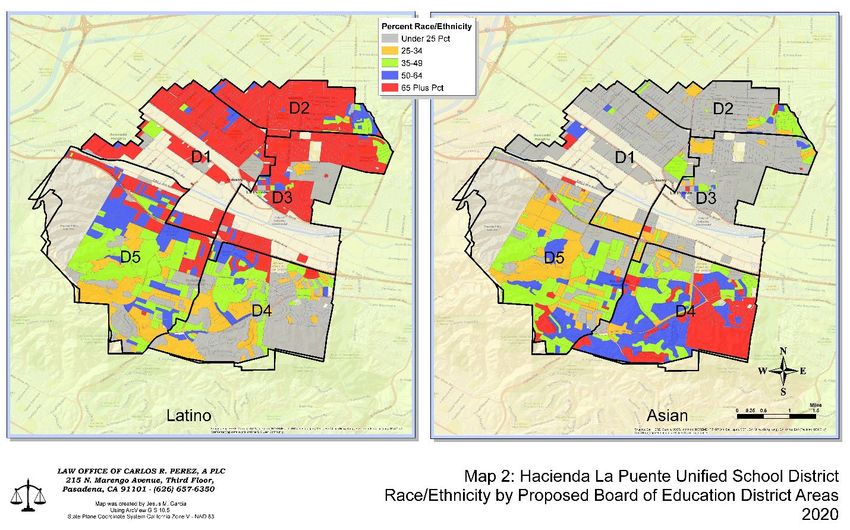
Table of Contents
Executive Summary ........................................................................................................................ 1
   GEOinovo Company Profile ....................................................................................................... 3
Subcontractor Information .............................................................................................................. 4
   La Cresta Demographics Overview ............................................................................................ 4
Examples of Work .......................................................................................................................... 4
   Community Level Mapping ........................................................................................................ 4
   Data Collection and Presentation ................................................................................................ 8
Representative Resumes ............................................................................................................... 12
   Staff Overview .......................................................................................................................... 12
   Organization Chart .................................................................................................................... 12
   Scope of Services Responsibilities............................................................................................ 12
   Staff Resumes ............................................................................................................................ 14
Cost Proposal ................................................................................................................................ 21
References ..................................................................................................................................... 22
Appendix B Conflict of Interest Forms ........................................................................................ 25
Addendum No. 1 ........................................................................................................................... 26
Addendum No. 2 ........................................................................................................................... 27

GEOinovo Solutions Inc.                                                  i                                                   City of Fresno
Executive Summary
May 14, 2021
Georgeanne White
Assistant City Manager
City of Fresno
Georgeanne.White@fresno.gov

Dear Georgeanne White,
GEOinovo Solutions Inc. (GEOinovo) is pleased to respond to the invitation for Request
for Proposal for Demographic Consulting Services for Redistricting Process. We believe we
provide the City of Fresno (City) with a competitive and responsive offering. For this project, the
GEOinovo Team will consist of GEOinovo and our subcontractor La Cresta Demographics.
As a GIS company, GEOinovo supports our clients with geospatial analysis, reports, dashboards,
and mapping services. GEOinovo has a simple goal, to solve complex problems through the
innovative use of Geographic Information Systems (GIS). Our comprehensive solutions
and extensive staff experience will provide the City with first-class demographic services and
demographic mapping. Our experience is augmented by our participation in the Esri, Inc. Partner
Program allowing us greater access to Esri’s GIS technology.
Our staff has extensive experience with local government mapping and providing GIS services.
We have created demographic mapping for redistricting and are familiar with the process and we
work with relevant parties such as lawyers, demographers, and the community. Our experience
includes developing and presenting maps to local government officials using GIS and
demographic mapping data.
We believe our Team is the most suited to provide services to the City because of our experience
and familiarity with Section II of the Federal Voter Rights Act of 1965, the California Voting
Rights Act of 2001, and the California Fair Maps Act of 2019. We have reworked and eliminated
poor redistricting efforts by leveraging our demographic experience and working closely with
appropriate law firms to ensure legal compliance. We use federal, state, and county data to
complete our demographic and voter participation analysis and draft district maps. Please note,
our work is dependent on the release of the U.S. Census Bureau decennial data. If the data is
released later than expected this will impact the schedule of the project. We understand that
redistricting is both a necessity and an art. It is critical to maintain compliance with federal and
state regulations and ensure community cohesiveness and inclusion.
Community level engagement is critical to meeting the California Fair Maps Act best practices.
Our Team has worked with community organizations to reach out to underrepresented
populations in Bakersfield, California through events, and small meetings. This work involved
creating maps and infographics to share critical information within the community. Using visuals
helps everyone understand the importance of redistricting and helps rally the community. We

GEOinovo Solutions Inc.                          1                                   City of Fresno
believe our Team has the right experience in the Central Valley of California and can provide the
City with unparalleled support with redistricting.
The GEOinovo team values close, interpersonal, and transparent relationships with project
participants at every level. We are a leading provider of innovative geospatial solutions in the
field with a known reputation for performance, quality, and reliability.
We believe that our solid reputation, extensive experience in the field, and selected staff provide
the necessary services that will meet the City’s requirements. We look forward to working
with you to meet your redistricting needs.
Please contact me, as the CEO and owner of GEOinovo, regarding this proposal.
Sincerely,

Luciane Musa, GISP - CEO                                GEOinovo Solutions Inc.
39252 Winchester Rd. #107-125                           Phone: 951-852-5205
Murrieta, California 92536                              Email: lmusa@geoinovo.com

GEOinovo Solutions Inc.                          2                                   City of Fresno
GEOinovo Company Profile
GEOinovo was founded in 2014 and incorporated in January 2018. We are a woman-owned,
minority-owned, and small business enterprise offering exceptional geospatial analysis, data
analysis, GIS and software integration, and program design services to meet the unique needs of
our clients. Our team brings over 80 years’ experience and success to each project and is guided
by our passion for delivering unmatched quality and unsurpassed services.
As a team comprised of talented individuals from diverse backgrounds such as GIS
professionals, demographers, anthropological professionals, and former military personnel, we
offer unique insight into each project. GEOinovo provides our partners with well-rounded
knowledgeable staff, unique technical and project expertise, strong partnership and leadership
skills, and most importantly meticulous and dedicated support. Our experience includes:
   •   Cartography (Mapping and
       Visualization)
   •   Data/Database Management                                    GIS &
                                                                  Mapping
   •   Redistricting
   •   U.S. Census Bureau Data
                                                     Voter
       Knowledge                                                               Redistricting
                                                     Rights
   •   GIS Architecture Design &
       Implementation
   •   Public Hearings and Public                               GEOinovo
       Outreach
   •   Map Production and Publication                                             Local
                                                    Geography
   •   ArcGIS Dashboard                                                        Government
       Configuration
   •   Forecasting and Modeling                                   Analysis
       Hypothetical Scenarios
California Small Business Designations:
    • SB(Micro) #2009714                              • DBE #45531
    • WMBE #17001156                                  • SBE # 20159741
Unmatched in our field, GEOinovo is motivated and driven to provide unique geospatial
solutions, open communications and accountability, exceptional relationships, and excellent
customer service.

                               Primary Point of Contact
                                Luciane Musa, Founder / CEO
                               39252 Winchester Rd. #107-125
                                 Murrieta, California 92536
                                    Phone: 951-852-5205

GEOinovo Solutions Inc.                         3                                  City of Fresno
Subcontractor Information
The GEOinovo Team will consist of GEOinovo and La Cresta Demographics. By teaming with
our subcontractor, the GEOinovo Team will provide the City with expertise across the multiple
dimensions of the project and provide the City with leading professionals in demographics,
GIS/map production, and community outreach.

La Cresta Demographics Overview
Mr. Garcia founded La Cresta Demographics in 2020 to provide demographics analysis,
community outreach, and redistricting services to government agencies throughout the United
States. The La Cresta Demographics team leverages over 30 years of experience and expertise in
voting rights, data analysis, community engagement, and much more. La Cresta Demographics
staff has supported over 20 California Voting Rights Act cases, providing subject-matter
expertise in demography, voting rights, and redistricting regulations. The exceptional
professional experience of La Cresta Demographics enables us to effectively communicate with
policymakers and citizens every step of the way to ensure fair and equitable outcomes for all
community stakeholders.
GEOinovo will use La Cresta Demographics as a subcontractor. La Cresta Demographics will be
responsible for performing the demographic analysis and proposing district boundaries. Further
details regarding scope of services responsibilities are outlined in “Scope of Services
Responsibilities”.

Examples of Work
Community Level Mapping
The GEOinovo Team brings many years of experience with demographic mapping to this
project. This experience includes redistricting many cities, school districts, and other local
jurisdictions across the State of California. We use data from the U.S. Census Bureau, American
Community Survey (ACS), and the California Statewide Database to populate our maps and
shapefiles. Our experience includes the use of the industry recognized ESRI platform, including
Esri Redistricting, Districting for ArcGIS, and ArcGIS Online. We provide maps in shapefiles,
paper maps, or through the web.
Specifically, the GEOinovo Team uses the data from the Decennial Census to analyze population
consistency and concentrations throughout the area of interest. This includes mapping the total
population by race, ethnicity, population over the age of 18, and Citizen Voting Age Population
by Race and Ethnicity (CVAP). We understand the importance of drawing districts that meet the
requirements of the Voting Rights Act such as preserving communities of interest (COI) for fair
representation.

GEOinovo Solutions Inc.                        4                                 City of Fresno
Figure 1 The above demographic maps show the percentage of the population that is Latino
and Asian in the Hacienda La Puente Unified School District. Mapping demographic data
provides an excellent visual tool to present data to the board of supervisors and the
community. In this example, the district boundaries accounted for the percentage of a
specific area that is made up of a majority racial/ethnic population.

Council District Mapping
The GEOinovo Team worked with a contract demography firm for the City to prepare draft
council district boundaries for new voting districts. The demographer worked with the City’s
legal team to analyze local demographic data and ensure compliance with the Federal Voting
Rights Act and California Voting Rights Act. Draft council district boundaries were submitted to
GEOinovo GIS staff for QA/QC to ensure geographic requirements were met for voting districts.
The review process included any necessary edits to ensure city council districts were contiguous,
provided in the appropriate geographic projection, included required attribute fields, and met
geometry requirements for analysis and display in web maps and printed maps.
In this case, attention to detail was very important to ensure accurate and useful geometry for the
approved council districts. The GIS staff utilized local knowledge and expertise to align
approved district boundaries with street centerlines, parcel boundaries, and city limits. These
edits have proven to be very useful to elected officials verifying addresses and streets within
individual districts and to the City Clerk staff responding to public requests for council district
information via the Council District web map.

GEOinovo Solutions Inc.                          5                                  City of Fresno
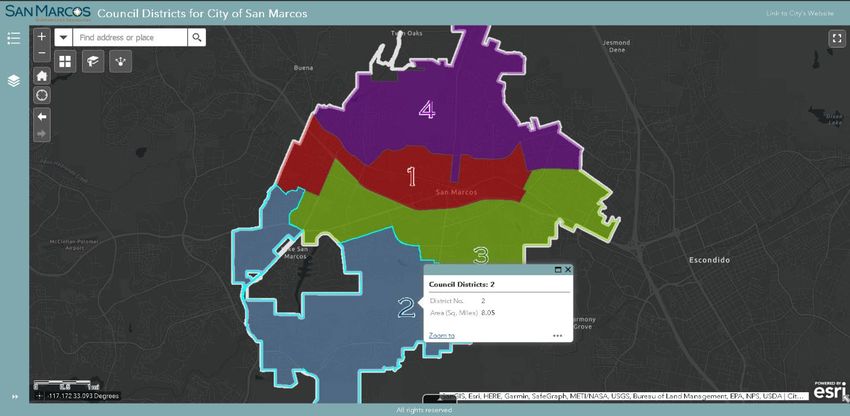
Figure 2 Interactive web map of City Council Districts in San Marcos, CA. The link to the
interactive web map is located here.

Demographic Analysis
Demographic analysis is crucial for analyzing the impacts a new project will have on the
surrounding communities. The GEOinovo Team used U.S. Census Bureau data to analyze the
communities surrounding the proposed runway extensions of the Plattsburgh International
Airport in both Erie, Pennsylvania and Plattsburg, New York. This project highlights our
experience working with demographic data, community and demographic analysis, and map
creation. The GEOinovo Team started by defining the area of influence of the runway extensions
and used Federal and State definitions of low-income and racial/ethnic protected populations. By
accessing U.S. Census Bureau data, we were able to determine the lowest level of aggregation of
each population type and determine the racial/ethnic protected group and low-income
composition of the affected area by overlaying the project area with the census tracts and block
groups/blocks. We created maps and reports of the area for each of the proposed alternatives.

                          {Remainder of page intentionally left blank.}

GEOinovo Solutions Inc.                        6                                  City of Fresno
Voting Rights Ensuring compliance with both Federal and California Voting Rights acts is critical for project success and avoiding litigation. The GEOinovo Team has supported projects to update school district boundaries to meet Voting Rights Act requirements. This work includes a thorough demographic analysis of the area of interest, understanding of the requirements of the Voting Rights Acts (Federal and California), district geography, voter registration and voting trends. Federal and California Voting Rights laws apply to redistricting projects from council districts to school districts. The GEOinovo Team has experience using U.S. Census Bureau data and conducting Citizen Voting Age Population (CVAP) analysis’ with consideration of the Federal Voting Rights Act requirements. Federal Voting Rights The GEOinovo Team has worked on many voting districts projects that required deep understanding of Section II of the Federal Voting Rights Act of 1965 and its application in redistricting. The Federal Voting Rights Act established, under law, the prohibition of discrimination on the basis of race, color, or membership in one of the language minority groups. Discrimination can include redistricting that create unusually large election districts among other elements of redrawing district lines. Violation of the 1965 Voting Rights Act can lead to legal issues and federal lawsuits. To avoid these negative consequences, the GEOinovo Team relies on our experienced staff and collaboration with legal teams, as necessary. California Fair Maps Act Best Practices Redistricting in California requires compliance with the California Fair Maps Act. The purpose of the Fair Maps Act is to ensure that redistricting creates maps that represent the demographic makeup of a community and prevent the dividing of communities of interest into separate districts. The GEOinovo Team is familiar with applying the many requirements and best practices of the Fair Maps Act to our redistricting projects. The GEOinovo Team supported the redistricting of the Kern High School District while complying with the industry best practices of creating geographically contiguous districts, districts providing racial/ethnic projected groups with an equal opportunity to participate in the political process, without being diluted, and minimizing the division of communities of interest to the extent practicable. Community engagement is critical to complying with the Fair Maps Act. The GEOinovo Team is familiar with online tools such as Districtr.org that allow people in the community to submit their own community of interest (COI) areas as shapefiles. Our Team has experience working with community organizers to actively engage with the community and encourage participation in the redistricting process. GEOinovo Solutions Inc. 7 City of Fresno
Data Collection and Presentation
Redistricting Whittier Union High School District
The GEOinovo Team provided Demographer/Statistician services to the Whittier Union High
School District (WUHS). This work included demographic analysis, community engagement,
participation in public hearings, producing district maps using input from the community, using
the best practices of the California Fair Maps Act prior to the when they became official law.
WUHS was under threat of lawsuit from the State of California for racially polarized voting.
Legal changes in redistricting required the WUHS to redraw their council districts to improve
racial/ethnic protected group representation. To engage with both the board and the community,
The GEOinovo Team provided statistical and demographic analysis of the previous council
districts and produced maps to help the board and the community better understand issues with
the district boundaries.
The redistricting process followed the following progression: (1) demographical and statistical
analysis of the population in WUHS, (2) mapping the geography of the area, (3) community
meetings/hearings/input, (4) creating three map iterations of the potential district boundaries, (4)
presenting potential maps to the board of supervisors, and (5) the adoption of the final map by
the board. Each stage in the process is critical for meeting the California Fair Maps and
California Voting Rights Acts best practices and regulations. Failure to meet these requirements
opens a district up to the threat of state or federal lawsuits. The GEOinovo Team has experience
supporting these best practices.
Demographic & Statistical Analysis
Demographic and statistical analysis starts with data collection. We used U.S. Census Bureau
Data from the American Community Survey, Redistricting Data from the California Statewide
Database, and Data from the County Registrar of Voters. Combining these data allowed for a
complete understanding of the district. After the initial maps and geospatial analysis were
completed, it was critical to engage with the community to better understand the reality of
communities of interest (COI) on the street level.
Community Engagement
Community engagement provides the opportunity to better understand the differences between
communities of interest within the district. These activities include community outreach, public
hearings and engaging with the community by allowing district residents to submit their own
maps of where they believe the district boundaries should be drawn.
Communities of Interest may be separated by geographical barriers such as freeways and
industrial zones and can include small well established community groups. Engaging with the
community meets the California Fair Maps Act best practices and helps incorporate ground level
community understanding into the final district maps.
Redistricting
After the initial analysis, community engagement, and draft boundaries, final district maps were
presented to the board of supervisors. Meeting the California Fair Maps Act best practices, the

GEOinovo Solutions Inc.                          8                                    City of Fresno
California Voting Rights Act, and the Federal Voting Rights Act, the new district boundaries
accounted for the three crucial demographics:
1) 50% plus 1 of the district population are from a racial/ethnic protected group.
2) 50% plus 1 of the Citizen Voting Age Population (CVAP) are from a racial/ethnic
protected group.
3) 50% plus 1 of the registered and likely voters are from a racial/ethnic protected group.
These three items are crucial for meeting the regulations under Section II of the Federal Voting
Rights Act. The maps below show the difference between compliant and non-compliant district
boundaries.
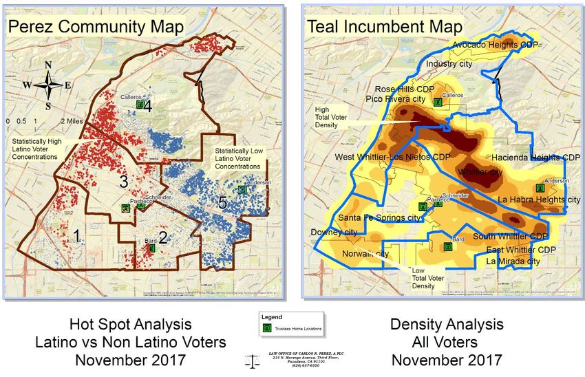
Figure 3 The above maps show the work the GEOinovo Team completed to re-do the voting
districts produced by a different firm (the Teal map on the right). The redistricting map to
the left – by the GEOinovo Team – accounts for voter location data as a core component for
preserving communities of interest. Both maps represent the spatial concentration of
geocoded individual registered Latino voters by competing proposed districts in Whittier
High School District redistricting in 2018. As a result of the updated map, the community of
Los Nietos Santa Fe Springs has achieved fair representation for the first time.
Covid 19 Demographic Analysis
The GEOinovo Team collaborated with Esri and City staff to gain access to data and tools for
providing public information during the early stages of the Covid-19 global pandemic. The result
was a Covid-19 dashboard and infographic to provide critical information to the public during
the first round of stay-at-home orders. The dashboard contained information for local businesses
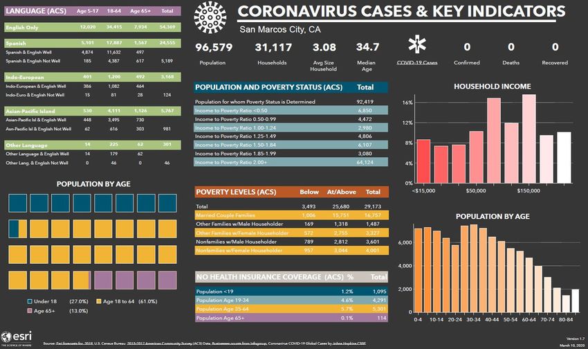
GEOinovo Solutions Inc. 9 City of Fresnoproviding take-out and grocery services and an interactive web map for citizens to view the locations from a browser or mobile device. The Covid-19 infographic provided information such as early case counts and demographic information that could be used by local government and citizens to monitor the spread of Covid-19 during the first wave of the pandemic. A public-facing school lunch web map was deployed to provide location information for low- income families to access no-cost school lunches during the pandemic. Our GIS Staff worked with the local school district to verify the sites and publish the information via ArcGIS Online. Figure 4 The above infographic shows early Covid 19 and demographic data for San Marcos, California. GEOinovo Solutions Inc. 10 City of Fresno
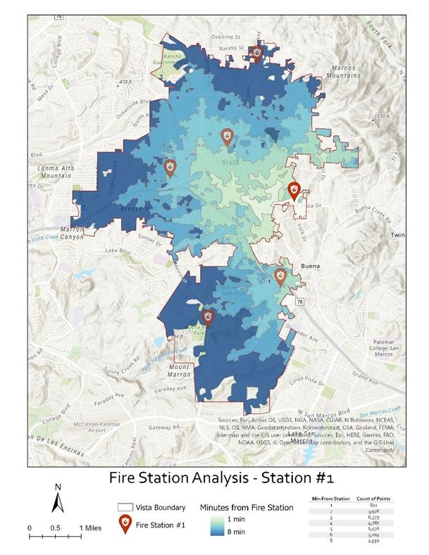
Geospatial Analysis and Map Production
Disaster preparedness is an
important function of any
government entity. This
importance is magnified in
Southern California with the
high frequency of wildfires and
the dangers those events pose to
life and property. GEOinovo’s
GIS staff collaborated with first
responders to update the local
inventory of designated
evacuation routes and evacuation
sites.
Evacuation sites are critical
infrastructure assets that can be
used during an emergency event.
Having an accurate inventory of
emergency sites helps local
government provide critical
services such as animal care,
emergency power for medical
services, temporary shelter, and
other local government
functions. These resources are
especially important for the
elderly, low-income families,       Figure 5 Utilizing network analysis, we performed a fire
and other disadvantaged             station coverage analysis throughout the City of Vista,
communities during emergency        California. This analysis was used to identify where a new
events.                             fire station would be needed.

Evacuation routes are critical for providing public information in case of an emergency event.
Local governments use this information to deploy Public Works personnel to appropriate
locations for road closures, detours, and coordination with law enforcement agencies to enforce
roadblocks during emergency events.

                          {Remainder of page intentionally left blank.}

GEOinovo Solutions Inc.                        11                                 City of Fresno
Representative Resumes
Staff Overview
The GEOinovo Team has assembled a team of experienced staff to provide full Demographer,
GIS, and Mapping services for this project. Combined, our Team has more than 100 years of
experience with demographic analysis and GIS. Our demographic services include experience
with the California Statewide Database and experience communicating data summary results to
public policy decision makers. We provide GIS services from GIS data cleanup to advanced GIS
analysis and modeling. As a technologically forward-thinking Team we strive for process
improvement and automation of GIS, database, and data management functions through software
development, widget creation, and scripting. Our Team supports demographic projects with
statistical analysis, reports, and understanding of voter requirements for both the U.S. Federal
Government and the California State Government. We work collaboratively to bring these
technical components together for products that are easy for policy makers to understand and
share with the public. To support our technical staff and partners, we offer Project Management
expertise in GIS and software development. The organizational chart below includes both the
staff and subcontractors who would support the City.
Organization Chart
Below is the anticipated project organization.
Luciane Musa
CEO / Project
Manager
Jesus Garcia
Alex Sainz
Demographer /
Sr. Consultant
Subcontractor
Candace Alejandra Garcia
Ming Hsueh
Paulman Community of
Sr. Consultant
Consultant Interest Liason
Scope of Services Responsibilities
As requested in the Request for Proposal, we have provided a breakdown, in the table below, of
all of the RFP requirements and by whom the requirements will be supported by. As the prime
contractor, GEOinovo Solutions Inc. will be responsible for the contract and deliverables. The
following table identifies who will be responsible for each task listed in the scope of work. The
GEOinovo Solutions Inc. 12 City of Fresnothree categories are GEOinovo Solutions, La Cresta Demographics, and The GEOinovo Team.
We will be working closely with our subcontractor La Cresta Demographics.
Responsible Scope of Services
Company
La Cresta At a minimum, such services should include advising and assisting the
Demographics City through each step of the district drawing process, including educating
the City and the public on the process and requirements, leading public
hearings, and workshops, assisting the public to draw and submit proposed
district maps on paper and online, and presenting recommendations to the
City Council.
The GEOinovo Agency must demonstrate a commitment to diversity and inclusion of all
Team stakeholders, activities to inform and solicit community input, and to
engage community throughout the process.
The GEOinovo Agency must demonstrate the use of inclusive and meaningful engagement
Team methods that will address the barriers to participation.
The GEOinovo Agency must be familiar with Assembly Bill 849 (2019), also known as
Team The Fair and Inclusive Redistricting for Municipalities and Political
Subdivisions (FAIR MAPS) Act.
Project Setup and Coordination
La Cresta Development of demographic database including Census Bureau and
Demographics California Statewide Database data of total population, citizen voting age
population, voter registration, voter turnout, and socio-economic data on
language spoken at home, renters vs homeowners, age, education level,
and other factors useful in identifying communities of interest.
The GEOinovo Incorporation of any Geographic Information System (GIS) data that the
Team City wishes to include and provides (including school locations; school
attendance areas; important local landmarks; or local neighborhood
boundaries).
La Cresta Compile population data by election area and calculate population
Demographics deviations of existing districts.
La Cresta Initial discussions with the City about data, communities of interest,
Demographics schedule, criteria, and special concerns of the jurisdiction.
The GEOinovo Assist City with developing a communications plan for public outreach,
Team including suggestions for webpage content and design, public feedback
logistics, and strategies for engaging constituents.
GEOinovo Assist City with developing a project plan, including a detailed timeline,
Solutions goals and objectives, and specific deliverables list.
The GEOinovo Provide progress reports on an as-needed basis and meet regularly as
Team determined by the City.
The GEOinovo Any phone- or web-conference calls to discuss the project’s progress or to
Team answer any questions that may arise.
La Crest Provide education and guidance on required redistricting criteria, and
Demographics advice on selecting optional redistricting criteria, for City staff and City
Council
Plan Development
GEOinovo Solutions Inc. 13 City of FresnoLa Cresta Provide memo on population balance and any potential divisions of
Demographics “protected class” population concentrations in the existing election areas
map.
GEOinovo Creation of 2 to 4 initial draft maps.
Solutions
The GEOinovo Analysis and preparation for presentation of all whole or partial plans
Team submitted by the public.
GEOinovo Conversion of all maps and reports to web-friendly versions.
Solutions
GEOinovo Online posting of all maps to an interactive review website.
Solutions
GEOinovo Create any requested additional and/or revised maps.
Solutions
Plan Implementation
GEOinovo Provide spatial data in GIS-friendly format of any dataset used or created
Solutions for this project to staff upon request.
La Cresta Work with the County Registrar of Voters to implement the final adopted
Demographics plan.
Project Options
GEOinovo Agency-prepared and -managed project website.
Solutions
GEOinovo Online mapping tool allowing resident to draw and submit map.
Solutions
GEOinovo Paper-based mapping tool allowing residents to draw and submit map.
Solutions
La Cresta Agency recommendation for outside specialist legal counsel.
Demographics
La Cresta Agency recommendation for outside outreach assistance.
Demographics
Staff Resumes
{Remainder of page intentionally left blank.}
GEOinovo Solutions Inc. 14 City of FresnoLanguages - Portuguese
Summary
Ms. Musa is the CEO and Founder of GEOinovo, where she oversees strategic
LUCIANE MUSA direction, company operations, and strategic relationships. Going beyond her duties
as CEO, Ms. Musa is a certified GISP and acts as a Project Manager and Senior GIS
Analyst on company projects. A pioneer in her field, Ms. Musa helped mold the
Spatial Data Standards for Facilities, Infrastructure, and Environment (SDSFIE)
requirements that govern the data standards per Department of Defense (DoD)
Highlights policy. She established geospatial standards, implemented and maintained GIS
system architectures, and created workflow processes. She heads projects across
Years of various fields, including environmental, public works, utilities, engineering,
transportation, military training initiatives, real estate, and public safety.
Experience
20 years
Selected Experience
GIS System Administrator/Project Manager, San Diego Regional Public
Education Safety (RPSG) GIS Program
• B.A. Geography / Ms. Musa’s responsibilities included preparing GIS data to be consumed by Tritech
Geographic Information 911 CAD and Mobile MDCs and editing public safety data such as Address Points,
Systems University of Street Centerlines, Buildings, and Hydrants. She reconciled, validated, and ensured
Alabama, Tuscaloosa, AL data accuracy in support of three 9-1-1 Dispatch Centers within San Diego County
and managed the GIS Public Safety Repository Database for the entire county. She
Certifications was responsible for the maintenance and administration of GIS software such as GIS
SDE and SQL databases. She published and managed web services from ArcGIS
• Geographic Information Server, Portal, and ArcGIS Online. In addition, she designed, planned, and
System Professional (GISP) implemented an improved GIS architecture to support advanced GIS software and
Certified extensions, providing the ability to scale to meet future GIS needs. Her work
• Project Management ensured the County transitioned to NextGen 911 requirements to make sure data is
Professional Academy compliant with NENA Standards.
Certification Senior GIS Analyst, Heartland Communications
Ms. Musa created, updated, and edited emergency response GIS data, and processed
Accomplishments GIS requests. Her responsibilities included processing data in the Tritech CAD
• Managed the San Diego system GISLink for 911 dispatchers and first responders. She validated and ensured
GIS Public Safety (RPSG) data accuracy from field data and contractor’s deliverables and generated Fire Map
Data Warehouse that books to be utilized in the fire trucks. Map books deployed to 100+ vehicles as a
supports over fifty local reference and back-up to existing digital systems.
government agencies. GIS Coordinator, N|V|5
• Architected and Ms. Musa was the GIS Coordinator for NV5. She set up ArcGIS Server enabling
implemented an Enterprise the creation of web services to support real time field data collection. She was
GIS System that included: responsible for the ArcGIS Portal administration and provided GIS training. She
Cloud Technology, migrated the database from PostgresSQL (open source) into SQL Server Enterprise
ArcServer, Portal, database. Her work improved workflow productivity by 70%.
GeoEvent, Image Server, GIS Skills Cartography, GIS Architecture Design &
ArcGIS Online, SQL & Implementation, Data Management, Enterprise GIS
SDE Databases, GIS Technology Esri Suite: ArcGIS Pro, ArcGIS Online, ArcGIS
establishing standards, best Exentions: Utility Network, ArcServer, GeoEvent and
practices, and training. Image Server, Drone2Map, Pix4D, Lidar, 3D Analyst,
Business Analyst, Dashboard, Image Analyst, Network
Languages Analyst, Spatial Analyst
Programming Software Integration, Programming / Scripting, Python,
• Arabic SQL, Web app development for mobile field application,
• Portuguese Cloud Technology Amazon Web Services, Microsoft Azure
• Spanish Database SDE, Enterprise SQL, Oracle, Access
Asset Management Maximo, DocScout, iNFADS
and Inventory
Data Collection Trimble, Leica, Collector for ArcGIS, Survey 123
GEOinovo Solutions Inc. 15 City of FresnoSummary
Mr. Garcia is a seasoned U.S. Census data demographer, voter redistricting
JESUS GARCIA researcher, and GIS analyst. His background and experience includes PL94-171 U.S.
Census data, American Community Survey (ACS), the Redistricting Database for
the State of California, K-12 education data, and SAS programming on large
databases. Mr. Garcia’s ability to communicate data summary results to
policymakers and the public make him a valuable collaborator in strategic planning
Highlights and community engagement efforts. He has demonstrated his abilities as a leader
throughout his career, managing staff with diverse backgrounds and abilities.
Years of Experience
Selected Experience
34 years
Demographic Statistician, U.S. Census Bureau Washinton, DC – Population
Education Division, Economic Census Division, Data User Services Division
Mr. Garcia performed final review of the 1990 Census statistical variables for
• Bachelor of Arts in Political Hispanic Origin, Place of Birth, Year of Entry, Citizenship, and Ancestry. He
Science, University of analyzed Economic Census Surveys of Minority Owned Businesses (SMOBE) and
California Santa Barbara Women Owned Businesses (WOB) P-20 Series Current Population Survey (CPS)
(UCSB), Santa Barbara, CA reports on the U.S. Hispanic Origin Population. He was the Spokesperson for the
• Master of Arts in Urban TIGER Files census data collection geographic boundary layers.
Planning University of Partnership Specialist, U.S. Census Bureau, Los Angeles, CA Field Division
California Los Angeles Mr. Garcia encouraged collaborations among community organizations, local
(UCLA), Los Angeles, CA governments, school districts, and local business to support Hard to Count (HTC)
• Certificate of Geographic community outreach efforts for the 2020 Census.
Information Systems, Chair Data Technology Committee, Kern Census Complete Count
California State University,
Committee
Bakersfield, CA
Mr. Garcia provided data analysis and GIS support in preparation for contacting
Skills Highlights Hard to Count (HTC) communities during the 2020 Census.
Consultant, Dolores Huerta Foundation (DHF)
• U.S. Census Data Analysis Mr. Garcia performed data analysis for various community and voter engagement
• Boundary Redistricting projects. Established the GIS department and led the DHF effort in Kern County,
• California Voting Rights California during the 2020 Census.
Act establishment of board Reasearch Assistant, Los Angeles Community College District (LACCD)
member districts areas As a Research Assistant, Mr. Garcia performed analysis and wrote his master’s
• Outreach Representative thesis based on the California Basic Educational Data Systems (CBEDS) data
collection process and the R30 Language Census program implemented by the
Accomplishments California Department of Education. Analysis tools included the Statistical Package
for the Social Sciences (SPSS) and first-generation GIS software on a PC. These
• Demographer and GIS
cutting-edge analysis tools were used to study need for bilingual education in
Analyst in over twenty
LACCD institutions in response to Immigration Reform and Control Act of 1986.
California Voter Rights Act
Lawsuits
GIS Skills Cartography, Geodatabase Design, Data Management, GIS
Language Analysis, Field Applications, Infographics
GIS ArcGIS Pro, ArcMap, ArcGIS Online, Business Analyst,
• Conversational Spanish Technology Dashboard
Database SQL, SDE, SAS
Data Collector for ArcGIS, Survey 123
Collection
Demographic Analysis, Cartography, Redistricting, California Voting Rights
Skills (CVR) Act, Hard to Count Communities (HTC), Community
Outreach
GEOinovo Solutions Inc. 16 City of FresnoSummary
ALEX SAINZ Mr. Sainz is a seasoned GIS professional who serves as a GIS Administrator and
Senior GIS Analyst for GEOinovo. His skills and abilities include ArcGIS
Enterprise services and applications, database management, on-premise and cloud-
based solutions, web services, data integration, and much more. He has first hand
experience working with local governments in Southern California. Mr. Sainz
possesses the ability to communicate technical concepts to stakeholders at all
Highlights organization levels, from the executive team to field staff. Beyond the creation and
modernization of the GIS infrastructure, Mr. Sainz is an expert data manager, able to
Years of Experience create compelling, relevant reports to ensure project adherence, as well as driving
decision making through actionable data.
12 years
Selected Experience
Education
GIS Administrator/Analyst, City of San Marcos
• Bachelor of Arts in Mr. Sainz managed and prioritized wide-ranging projects and data requirements
Geography – Urban and along with managing expectations throughout the organization. His position
Regional Analysis, San demanded sufficient technical, collaboration, and leadership abilities to operate as a
Diego State University, San one-person GIS operation. He was responsible for project and database management
Diego, CA and lead an ArcGIS Enterprise deployment resulting in increased accessibility to
data and apps throughout the organization. Mr. Sainz managed web services,
Accomplishments
database management, and ArcGIS integration with the City’s asset management,
• San Diego Regional GIS land management, and records management systems.
Council (SDRGC) As the City’s GIS Administrator, Mr. Sainz oversaw editing and quality control
Chairperson (previously operations for city council districts. The review process included any necessary edits
Vice Chairperson and to ensure city council districts were contiguous, contained required attributes, and
Secretary). met geometry and projection requirements for analysis and display in web and
• Esri User Conference printed maps.
Presenter. GIS Specialist/Coordinator, City of Chula Vista
• Public/Private/Education Mr. Sainz collaborated with technical and operational personnel, communicated
Partnership for Unmanned project updates to leadership, and represented the City at regional project
Aerial Systems (UAS) with meetings/committees. He tested and implemented GIS automation and workflow
Palomar College. tools and leveraged innovative solutions such as Attribute Assistance for ArcMap.
Mr. Sainz modernized nearly two decades of legacy data in under two years. The
Presentations long-term results of his work have provided high-quality GIS data to first responders
throughout San Diego County.
• San Diego Regional GIS
Council, Enterprise GIS for GIS Specialist, Heartland Communications
City Operations. Mr. Sainz provided the professional GIS Services required to maintain mission-
• Palomar College, migrating critical GIS data in a location-based 9-1-1 CAD system. Responsibilities included
from ArcMap to ArcGIS maintaining 9-1-1 routing, response areas, address data and representing member
Pro Presentation/Training: agencies in the Regional Public Safety Geodatabase (RPSG) program.
Migrating from ArcMap to GIS Skills Cartography, Geodatabase Design and Administration, Data
ArcGIS Pro. Management, Enterprise GIS, Field Applications, Infographics
• 2014 Esri User Conference GIS ArcGIS Pro, ArcMap, Model Builder, Attribute Assistant,
Technology Attribute Rules, ArcGIS Online, ArcGIS Server, Business Analyst,
Dashboard, Web AppBuilder, ArcGIS Exentions: Utility Network,
Network Analyst, Spatial Analyst
Database SQL, Enterprise Geodatabase
Application Lucity, TRAKiT, Laserfiche, TriTech Software Systems
Integrations
Data Trimble, Collector for ArcGIS, Survey 123
Collection
GEOinovo Solutions Inc. 17 City of FresnoSummary
Ms. Paulman, GISP is a skilled GIS professional with over 15 years of experience
CANDACE with all things GIS. From her direct engineering experience with Esri to her robust
PAULMAN involvement with projects ranging from public safety and defense to environmental
and transportation, Ms. Paulman brings immense critical skills to every project. Her
ability to work with complex geodatabases as well as conduct spatial analysis makes
her an invaluable analyst. As a former Esri product engineer, Ms. Paulman also
Highlights brings a unique and intimate knowledge of creating ArcGIS extensions for the
defense and intelligence communities. Ms. Paulman is an expert in crafting business
intelligence dashboards and reports. She excels in constructing critical preplans for
Years of first responders using real-time GIS data to ensure our clients have the most accurate
Experience and up to date information to make informed and intelligent decisions.
15 years Selected Experience
Education Senior GIS Analyst, City of San Diego
• M.S. Environmental As the Senior GIS Analyst, Ms. Paulman oversees the maintenance and creation of
Science, emphasis in the department’s Pre Fire plans. She has updated the program to use real-time data
Mapping Science, State hosted online. Now, newly exported reports from ArcGIS Pro as well as the GIS
University of New York service used in the field are coming from the same live data. Ms. Paulman also
• B.A. Computer Information created three services on the City’s internal GIS Server for the purpose of accessing
System, University of and tracking the properties and assets associated with the Pre Fire plan program. She
Dayton Ohio created a new database schema for the purpose of streamlining county-wide
structure preplan data and having all municipalities on a common operating picture.
Certifications GIS Services Contractor, Groundpoint Technologies
• Geographic Information As the GIS Services Contractor, Ms. Paulman verified, corrected, and digitized
System Professional (GISP) hydrography layers using NHD datasets, satellite imagery, and Lidar data in an
Certified ArcGIS spatial database.
Quality Assurance Manager, SAP, Roambi
Accomplishments In her role as the Quality Assurance Manager, Ms. Paulman participated in and led
• Authored and presented quality assurance activities for major releases of Roambi Analytics and Roambi
over thirteen whitepapers at Flow. The releases encompassed both on-premise Enterprise and cloud-based SaaS
various GIS Conferences. server offerings and their corresponding mobile clients. Ms. Paulman created custom
• Assisted development of the Business Intelligence reports to verify customer issues using Microsoft SQL Server
ArcGIS extension for the
Reporting Services, IBM Cognos, and SAP Business Objects.
Defense and Intelligence
communities. GIS Skills Cartography, Geodatabase Architecture Design &
Implementation, Data Management, Enterprise GIS, Data
Presentations collection / digitizing
GIS Technology Esri Suite: ArcGIS Pro, ArcGIS Online, ArcGIS Server,
• 13th Annual SCGIS ArcGIS Exentions: Spatial Analyst, 3D Analyst, Model
International Conference, Building
Monterey, CA, July 8-11, GPS
2010. Addressing Statewide Lidar – Analysis with lidar derrived data
Habitat Connectivity. Programming Software Integration, Python scripting
. Cloud Amazon Web Services
Technology
Database Microsoft SQL Server (basic level)
Asset Assist county with reconciling fire hydrant data using
Management and existing datasets and aerial imagery.
Inventory
Data Collection Trimble, Collector for ArcGIS, Survey 123
GEOinovo Solutions Inc. 18 City of FresnoSummary
Mr. Hsueh is a talented and experienced Developer, Programmer, and DBA with an
MING HSUEH innate ability to understand all things within information technology, streamline and
automate processes, and create and develop applications. His contributions to clients
increase productivity by modernizing and automating manual processes to save time
and reduce errors. His extensive professional history includes in-depth work with
Highlights relational databases and program development focused on SQL Server, Microsoft
Stack, and .Net Framework/.Net core.
Years of
Selected Experience
Experience
Sr. GIS Analyst/Developer, Heartland Communications
25 years Mr. Hsueh assisted in the development of the data score card and developed
applications to consume SABER and WAZE API data. He analyzed database
Education structures and rewrote data analytics to accelerate the data calculation process from
a task that previously took over 1 hour to less than 30 seconds.
• M.S. Mechanical
Engineering/Control
GIS Analyst/Developer, Heartland Communications
Systems, California State Mr. Hsueh served as the GIS Analyst/Developer of Heartland Communications. In
University, Fullerton, CA this role he georeferenced new communities and updated and enhanced Heartland
Communications routing layers. Mr. Hsueh developed a one-click deployment
• B.S. Mechanical
application utilizing Visual Studio Dot Net to simplify the MDC update process for
Engineering/Control
the fire agencies when the new monthly routing was to be deployed.
Systems, University of
California, Los Angeles, IT Development Lead, City of San Diego
CA Mr. Hsueh developed and implemented various REST and SOAP APIs for multiple
process improvements and enhancements, including the sales of GIS tracking
Certifications module by the entire Sales Team. He implemented a Financial Calculation
improvement that took a 7-day process down to 20 minutes.
• Certification Project Senior SQL Developer/Programmer/DBA, Buffini & Company
Management Professional As the Senior SQL Developer, Mr. Hsueh migrated over 50 reports from Crystal
Academy Reports to Microsoft SQL SSRS. He analyzed, redesigned, and simplified the sales
commission’s application to allow the accounting department to handle 99% of the
Accomplishments commissionable sales without the IT department’s assistance.
• Developed a process to Senior Business Analyst, Abbott Vascular
update hundreds of GIS Mr. Hsueh was the technical lead for the team that developed Abbott Vascular’s
public safety mobile Business Process Scorecard (BPS) used to analyze and present the various
computers resulting in a departments’ performance at Abbott Vascular.
90%-time savings. GIS Skills Cartography, GIS Architecture Design & Implementation,
• Implemented an MS SQL Data Management, Enterprise GIS
system to create multiple GIS Technology Esri Suite: ArcGIS Pro, ArcGIS Online, ArcGIS
backups and restore files Exentions: Utility, ArcServer, GeoEvent and Image Server
reducing the backup and
restore times by up to 40%. Programming Visual Studio, Entity Framework, C#, C++, Visual Basic,
• Tuned SQL queries to work Language Integrated Query (LINQ), Software Integration,
with sets and improved GitHub, TFS, VBA, Windows Communication
processing times from 7-8 Foundation (WCF), REST APIs, SOAP APIs, JSON,
hours to process now take XML, ASP.NET, Model-View-Controller (MVC),
less than 10 minutes. Windows Forms, Windows Presentation Foundation
(WPF)
Language Cloud Technology Amazon Web Services, Azure Cloud Services
• Conversational Mandarin Database Microsoft SQL Server, T-SQL, Stored Procedures,
Chinese Triggers, Service Broker, SSIS, SSRS, MS Access, MS
FoxPro
GEOinovo Solutions Inc. 19 City of FresnoSummary
ALEJANDRA Ms. Garcia has an extensive background in community engagement and
social issues gained through years of dedication and hard work. Her expertise
GARCIA and strong work ethic make her a valuable asset for raising awareness and
mobilizing community stakeholders to make their voices heard during the
redistricting process. Ms. Garcia’s knowledge and communications skills are
key components to project success.
Highlights
Selected Experience
Years of Experience Facilitator, Building Healthy Communities
As the Facilitator of Building Healthy Communities, Ms. Garcia was the co-
16 years
chair of the Kern County 2020 Census Complete County Community effort
Education to promote and raise awareness about the importance of the 2020 Census.
Her talent as an excellent communicator resulted in various community
• Geographic Information groups rallying towards the common goal of achieving an accurate census for
Systems Certificate, the communities she serves. This effort is even more impressive considering
California State University the unprecedented challenges of the COVID-19 pandemic. The connections
Bakersfield, Bakersfield, and relationships Ms. Garcia has worked so hard to build will encourage
CA
organizations and citizens to make their voices heard throughout the
Organizations redistricting process.
Program Coordinator, Kern Literacy Council
• Urban and Regional Ms. Garcia planned, organized, and directed operations for the Kern Literacy
Information Systems Council. Her contributions to the tutoring program included recruitment and
Association (URISA), training for new candidates, recruitment of students in need of educational
Equity Social Justice support, and oversight of the matching process between tutors and students.
Committee This inspirational work provided literacy services for underserved adults
• Latina Leaders Kern throughout Kern County, opening doors for career opportunities and growth
County (former Vice Chair) that would otherwise be out of reach.
• Hispanas Organized for Field Representative, California State Assembly
Political Equality (HOPE), Ms. Garcia served as a Field Representative on behalf of Danny Gilmore and
Class of 2011 Nicole Parra from 2007-2010. Her responsibilities included building and
• Mexican American maintaining productive relationships with community stakeholders,
Opportunity Foundation including local government entities, Chamber of Commerce, faith-based
(MAOF), Former Board organizations, youth organizations, and public safety professionals. Her team
Member successfully engaged Kern County constituents through district-sponsored
• School Site Council activities and events.
Representative, East High Community Impact & Investment Manager, Kern County United Way
School, Compton Junior As the Community Impact and Investment Manager for United Way of Kern
High, Cesar Chavez County, Ms. Garcia facilitated the community investment process and
Elementary.
provided quarterly monitoring and reporting on behalf of the organization.
• Cesar Chavez Elementary
Other key responsiblities of this role included strong communication and
School Parent
Organization, President building relationships with community partners and stakeholders. This role
provided Ms. Garcia with the opportunity to participate in Vision Council
functional area activitities such as training and volunteer management.
Public Outreach Public speaking, community engagement,
presentations, training, advocacy
GIS Skills Cartography, Data Management, Data collection /
digitizing
Data Collection Trimble, Collector for ArcGIS, Survey 123
GEOinovo Solutions Inc. 20 City of FresnoCost Proposal
GEOinovo proposes a fixed fee of $65,000 for the scope of services defined in the Request for
Proposal. Additional services outside of the items summarized below will be charged using the
Labor Categories and Hourly Rates detailed below.
Scope of Services Tasks Cost (USD)
Project Setup and Coordination Included in the Fix Fee
Plan Development Included in the Fix Fee
Plan Implementation Included in the Fix Fee
Project Options Included in the Fix Fee
Fix Fee $65,000
Project Options Cost (USD)
Agency-prepared and managed project website $5,000
Online mapping tool allowing residents to draw and submit maps Included in the Fix Fee
Paper-based mapping tool allowing residents to draw and submit Included in the Fix Fee
maps
Agency recommendation for outside specialist legal counsel Included in the Fix Fee
Agency recommendation for outside outreach assistance Included in the Fix Fee
Optional Language Translation (Written Materials) Cost (USD)
Spanish $45 per 100 words
Hmong $55 per 100 words
Punjabi $45 per 100 words
Labor Categories Hourly Rate (USD)
Demographer $280
Senior Consultant $240
Communications Specialist $240
Project Manager $150
Technical Writer $130
Analyst $75
Clerical $50
GEOinovo established our pricing based on the following project assumptions:
1. Perform up to 5 community meetings/hearings.
2. Website translations into Spanish, Hmong, and Punjabi are included in the fixed fee.
3. Translation of additional materials will be costed according to the prices listed in the
“Optional Language Translation (Written Materials)” table above.
4. Interpretation/Live Translation services will be provided in a separate quote once the
requirements are further defined.
GEOinovo Solutions Inc. 21 City of FresnoReferences
San Diego Regional Public Safety GIS Program (RPSG)
SAN DIEGO REGIONAL PUBLIC SAFETY GIS
PROGRAM (RPSG)
Reference Contact Project Summary
Name: Jennifer Libby-Jones GEOinovo provided staff for the RPSG project both for regular staff
Title: Communications Manager augmentation as well as additional project support. We staffed the
Group/Division: North County project with three remote positions. The Regional Public Safety
Dispatch JPA Geodatabase Program aims to create standardized data, products, and
Phone: (858) 400-2803 geospatial services for fire, medical, and law enforcement personnel
within San Diego County. The talented team at GEOinovo provided
Email: Jlibby-jones@sdrecc.org
services in modeling, designing, documenting, programming,
Period of Performance maintaining, and testing Geographic Information Systems (GIS)
2012-2020 applications, models, procedures, and software routines to automate
Project Cost geographic analysis and data processing. Our responsibilities include
$400,000 budget oversight duties, geodatabase design, administration, and
automated processing tools, including GIS programming, managing
Related Tasks the successful deployment and maintenance of many GIS
• Coordinated data collection deliverables.
and integration. While this project directly benefits the public safety agencies, the
• Development of cartographic contributions and work performed by GEOinovo expanded and
products such as map books, touched multiple aspects of the County, including transportation
wall maps, digital maps, web- planning, traffic, construction, utility management, impact
forecasting, community relations, and more. This project included
based map services significant effort and work across multiple sub-projects. For clarity
• Made recommendations we have provided a summary of the demographic services we
regarding upgrades, performed.
considering the implications
Demography and Analysis
of new or revised GIS
software, equipment, or The role of demographics in Fire Safety is a crucial aspect of serving
applications. our communities better. In support of public safety, GEOinovo
performed a demographic, geospatial analysis of the communities
• Third-party software supported by RPSG. We obtained demographic data from the U.S.
integration with GIS Census Bureau for the area each dispatch center supported. This data
• Obtained U.S. Census Bureau included population count, language spoken, race, age, and gender.
data for Geospatial Analysis. Using the Census data, we determined which dispatch centers would
need to improve their services to meet the needs of the predominate
• Data exchanged with other language spoken in that area.
government agencies.
With new developments throughout the county, a population growth
study was needed to analyze what areas may need additional support.
More than two thousand preplan fire maps were created to identify
buildings, types of occupancies, and assist firefighters with
emergency route planning.
U.S. Census Bureau statistics data were used to quantify the number
of homes without smoke alarms. This data was used by the California
Fire Prevention Organization to install free smoke alarms.
GEOinovo Solutions Inc. 22 City of FresnoYou can also read