City of Rockingham Mersey Point Bus Terminus Offset Revegetation Plan
←
→
Page content transcription
If your browser does not render page correctly, please read the page content below
City of Rockingham
Mersey Point Bus Terminus
Offset Revegetation Plan

Natural Area Holdings Pty Ltd
57 Boulder Road, Malaga, WA, 6090
Ph: (08) 9209 2767
info@naturalarea.com.au
www.naturalarea.com.au
City of Rockingham
Mersey Point Bus Terminus Offset Revegetation Plan

Disclaimer
Natural Area Holdings Pty Ltd, trading as Natural Area Consulting Management Services (Natural Area), has
prepared this report for the sole use of the Client and for the purposes as stated in the agreement between
the Client and Natural Area under which this work was completed. This report may not be relied upon by any
other party without the express written agreement of Natural Area.

Natural Area has exercised due and customary care in the preparation of this document and has not, unless
specifically stated, independently verified information provided by others. No other warranty, expressed or
implied, is made in relation to the contents of this report. Therefore, Natural Area assumes no liability for
any loss resulting from errors, omission or misrepresentations made by others. This document has been
made at the request of the Client. The use of this document by unauthorised third parties without written
permission from Natural Area shall be at their own risk, and we accept no duty of care to any such third
party.

Any recommendations, opinions or findings stated in this report are based on circumstances and facts as
they existed at the time Natural Area performed the work. Any changes in such circumstances and facts
upon which this document is based may adversely affect any recommendations, opinions or findings
contained in this document.

No part of this document may be copied, duplicated or disclosed without the express written permission of
the Client and Natural Area.

       Document
                 NAH COR Mersey Point Bus Terminus Revegetation Plan
           Title
        Location Client Folders NAC V2\City of Rockingham\Mersey Point - Bus Terminus\Report
  Draft/Version
                    Date                  Changes          Prepared by       Approved by          Status
  No.
                                                                                              Draft for client
  D1                15/02/2021        New Document           KG, MG               SH           review and
                                                                                                comment
                                          Minor
  V1                06/04/2021                                  SH                BC               Final
                                        amendments

                                                          Natural Area Holdings Pty Ltd © 2021 |Page 2 of 88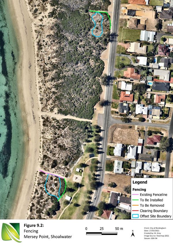
City of Rockingham
Mersey Point Bus Terminus Offset Revegetation Plan

Executive Summary

Natural Area Consulting Management Services (Natural Area) was commissioned by the City of Rockingham
(the City) to prepare an offset revegetation plan which includes a detailed flora and vegetation assessment
and a basic fauna survey. Surveys were undertaken in the proposed clearing area and the proposed offset
planting areas to prepare an offset revegetation plan. The proposed clearing is required for the installation
of a new bus terminus adjacent to Arcadia Drive, Shoalwater. Survey outcomes are presented in this plan to
support the clearing permit application processes for the City.

The survey of the Mersey Point (proposed clearing area) site identified:
    ▪ a total of 26 flora species from 16 families of which 14 were introduced and 12 native species
    ▪ the presence of one vegetation type Acacia rostellifera Shrubland
    ▪ vegetation condition across the site being Good
    ▪ no threatened ecological communities
    ▪ two bird species within the survey area, Willie Wagtail (Rhipidura leucophrys) and *Laughing Turtle
        Dove (Spilopelia senegalensis).

Five proposed revegetation areas were identified to offset the residual impact of clearing vegetation for the
proposed Mersey Bus terminal site. All areas are found within the same dune system along Shoalwater
Beach. These areas were selected as they are also located within the Bush Forever Site 355, to maintain the
vegetation cover within the site and enhance vegetation condition present in the area.

The survey of the proposed offset sites identified the following:
    ▪ One vegetation type was present across all sites, Acacia rostellifera Shrubland.
    ▪ Three of the proposed offset sites have recent signs of revegetation efforts.
    ▪ Vegetation condition ranged from Good to Completely Degraded.
    ▪ Two fauna species were observed during the survey, Ctenotus fallens and the European Rabbit
        (Oryctolagus cuniculus), with the European Rabbit listed as a C3 declared pest.

The aim of the revegetation activities within the proposed offset sites are to:
    ▪ restore the sites to self-sustaining ecosystems that extend into the existing areas of vegetation
    ▪ restore understory cover and increase species diversity
    ▪ remove competition on native flora due to presence of invasive species.

A revegetation strategy has been developed for the five proposed offset sites which includes aspects of site
preparation including weed control, pest animal control, rubbish removal and fencing, with indicative
planting numbers and a cost schedule provided. For the revegetation works to be considered successful, the
following completion criteria have been assigned:
     ▪ one plant per square metre by year 5
     ▪ 70% survival of tubestock by year 5
     ▪ at least 90% of species in the planting list are represented in total species composition by year 5
     ▪ a maximum of 5% weed coverage within the offset sites
     ▪ vegetation condition in offset sites to be Good or better to match what was found in the clearing
        area.

                                                          Natural Area Holdings Pty Ltd © 2021 |Page 3 of 88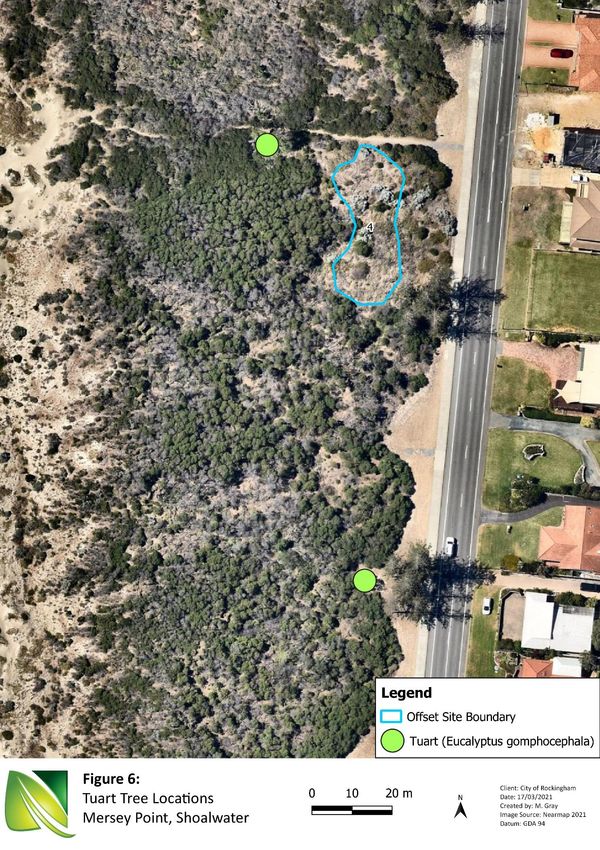
City of Rockingham
Mersey Point Bus Terminus Offset Revegetation Plan

Contents

Executive Summary ......................................................................................................................................................3
Contents .......................................................................................................................................................................4
1.0        Introduction .....................................................................................................................................................6
    1.1        Scope ............................................................................................................................................................6
    1.2        Objectives ....................................................................................................................................................6
    1.3        Location........................................................................................................................................................6
       1.3.1           Mersey Point Site.................................................................................................................................7
       1.3.1           Offset Sites...........................................................................................................................................7
    1.4        Site History ...................................................................................................................................................7
    1.5        Tenure and Current Land Use ......................................................................................................................7
2.0        Site Characteristics ...........................................................................................................................................9
    2.1        Regional Context ..........................................................................................................................................9
    2.2        Climate .........................................................................................................................................................9
    2.3        Topography and Soils ...................................................................................................................................9
    2.4        Vegetation Complex...................................................................................................................................10
    2.5        Hydrology ...................................................................................................................................................10
3.0        Methodology ..................................................................................................................................................12
    3.1        Desktop and Literature Review ..................................................................................................................12
    3.2        On-ground Flora Survey .............................................................................................................................12
       3.2.1           Vegetation Type.................................................................................................................................13
       3.2.2           Vegetation Condition.........................................................................................................................14
    3.3        Limitations .................................................................................................................................................15
4.0        Results ............................................................................................................................................................16
    4.1        Desktop Survey ..........................................................................................................................................16
       4.1.1           Significant Flora .................................................................................................................................16
       4.1.2           Threatened Ecological Communities .................................................................................................16
       4.1.3           Significant Fauna................................................................................................................................17
    4.2        Survey Results – Mersey Point Bus Terminus Site .....................................................................................18
       4.2.1           Flora ...................................................................................................................................................18
       4.2.2           Vegetation Type.................................................................................................................................18
       4.2.3           Threatened and Priority Ecological Communities .............................................................................18
       4.2.4           Vegetation Condition.........................................................................................................................19
       4.2.5           Fauna .................................................................................................................................................19

                                                                                             Natural Area Holdings Pty Ltd © 2021 |Page 4 of 88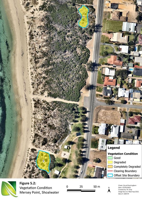
City of Rockingham
Mersey Point Bus Terminus Offset Revegetation Plan

  4.3         Survey Results – Offset Sites ......................................................................................................................24
      4.3.1          Flora ...................................................................................................................................................24
      4.3.2          Vegetation Type.................................................................................................................................24
      4.3.3          Threatened Ecological Communities .................................................................................................25
      4.3.4          Vegetation Condition.........................................................................................................................26
      4.3.5          Fauna .................................................................................................................................................26
5.0     Revegetation Plan Objectives ........................................................................................................................28
  5.1         Revegetation Requirements ......................................................................................................................28
  5.2         Revegetation Aims .....................................................................................................................................28
6.0     Revegetation Plan ..........................................................................................................................................29
  6.1         Site Preparation .........................................................................................................................................29
      6.1.1          Weed Control.....................................................................................................................................29
      6.1.2          Pest Animal Control ...........................................................................................................................32
      6.1.3          Rubbish Removal ...............................................................................................................................32
      6.1.4          Fencing...............................................................................................................................................33
  6.2         Revegetation Methodology .......................................................................................................................37
      6.2.1          Sourcing of Tubestock .......................................................................................................................37
      6.2.2          Planting ..............................................................................................................................................37
      6.2.3          Planting Density .................................................................................................................................37
      6.2.4          Watering ............................................................................................................................................37
      6.2.5          General Maintenance ........................................................................................................................37
  6.3         Flora Species List ........................................................................................................................................38
  6.4         Completion Criteria ....................................................................................................................................40
  6.5         Monitoring .................................................................................................................................................40
7.0     Implementation and Cost Schedules .............................................................................................................41
  7.1         Implementation Schedule ..........................................................................................................................41
  7.2         Indicative Costings .....................................................................................................................................41
8.0     References......................................................................................................................................................43
Appendix 1:          NatureMap Report ............................................................................................................................46
Appendix 2:          Protected Matters Search Tool Report ..............................................................................................61
Appendix 3:          Conservation Codes ...........................................................................................................................80
Appendix 4:          Mersey Point Flora List ......................................................................................................................83
Appendix 5:          Offset Site Flora List ...........................................................................................................................84
Appendix 6:          Quadrat Data .....................................................................................................................................86

                                                                                           Natural Area Holdings Pty Ltd © 2021 |Page 5 of 88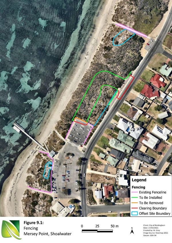
City of Rockingham
Mersey Point Bus Terminus Offset Revegetation Plan
1.0 Introduction
Natural Area Consulting Management Services (Natural Area) was commissioned by the City of Rockingham
(the City) to prepare an offset revegetation plan which includes a detailed flora and vegetation assessment
and a basic fauna survey. The assessment was undertaken within the proposed clearing area and the
proposed offset planting areas to prepare an offset revegetation plan. The proposed clearing is required for
the installation of a new bus terminus adjacent to Arcadia Drive, Shoalwater. Survey outcomes are
presented in this plan to support the clearing permit application processes for the City.
1.1 Scope
Natural Area’s scope of works associated with the revegetation plan included:
▪ desktop database searches to identify flora ecological communities that may be present at the site,
including any conservation significant species and ecological communities
▪ desktop review of available data for the site including vegetation complex, soils characteristics and
topography
▪ a site survey to:
- document vegetation condition within both areas (to be cleared and proposed offset sites)
- flora survey of species present (native and non-native)
- determine key site characteristics
- determine the extent of vegetation types and condition
▪ reporting survey outcomes and preparing an offset revegetation plan in line with Department of
Water and Environmental Regulation’s A guide to preparing revegetation plans for clearing permits
▪ preparation of documentation required to obtain clearing permit.
1.2 Objectives
The aim of the revegetation plan is to investigate the condition of the proposed clearing area and the
proposed offsets sites. Including determining suitable species to be planted in revegetation sites.
Accordingly, this plan will:
▪ describe the Offset sites, including location and description of key characteristics
▪ outline management aims and objectives for each offset site
▪ describe rehabilitation activities, rationale, and methodology for each offset site
▪ provide success criteria, monitoring and reporting requirements for each offset site
▪ describe contingency plans if success criteria are not met for each offset site
▪ outline weed and pest control activities for the offset sites
▪ provide an indicative implementation schedule and costings for each offset site.
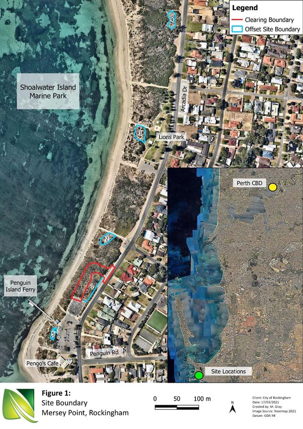
1.3 Location
The proposed clearing area and offset sites are approximately 42 km’s west of the Perth Central Business
District, within the suburb of Shoalwater in the City Rockingham (Figure 1). The sites are situated within the
vegetated dune system of Shoalwater Beach adjacent to the Shoalwater Island Marine Park. The proposed
clearing area and offset sites are located within the Bush Forever Site – 355 (Point Peron and Adjacent
Bushland, Peron/Shoalwater Bay) (Department of Planning, Lands and Heritage, 2021).
Natural Area Holdings Pty Ltd © 2021 |Page 6 of 88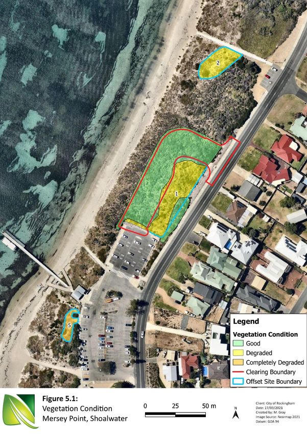
City of Rockingham
Mersey Point Bus Terminus Offset Revegetation Plan

1.3.1 Mersey Point Site
The proposed site for the Mersey Bus terminal area is located on the northern end of the Mersey Point Jetty
carpark extending to Arcadia Drive, this covers an area of 0.252 ha of remnant coastal scrub. The clearing
area is located within Lot 24 on Deposited Plan 243261 (Reserve 22948) (PIN 11425501), adjacent to Arcadia
Drive and in close proximity to facilities servicing tourism for Penguin Island, including Pengo’s café and the
Penguin Island Ferry (Figure 1).

1.3.1 Offset Sites
Five proposed offset sites were identified to offset the residual impact of clearing vegetation for the
proposed Mersey Bus terminal site. All sites are found within the same dune system along Shoalwater
Beach, with the furthest offset site located approximately 0.5 km north of the clearing area (Figure 1). Offset
sites were chosen based on the similarity of vegetation type to the clearing area, close proximity to clearing
site and the fact that they also make up part of the Bush Forever Site 355. With the outcomes of the offset
meant to enhance vegetation cover and condition within Site 355.

1.4     Site History
The greater area along Shoalwater Beach including Penguin Island forms the Shoalwater Island Marine Park,
which consists of four zones:
    1. ‘no take’ sanctuary zones
    2. special purpose zone (wildlife protection)
    3. special purpose zone (scientific reference)
    4. general use zone.

As a result of the area’s high conservation value, it also holds high commercial, tourism and cultural values
(Cardno, 2019 & GHD Woodhead, 2019). Two grants were approved in previous years regarding the coastal
rehabilitation of Shoalwater Beach, with the Shoalwater Foreshore Beach Path and Coastal Rehabilitation
Project awarded in 2012 and the Coastal Rehabilitation at Shoalwater Bay Beach, Shoalwater being awarded
in 2016 (DPLH, 2020). This highlights the ongoing attempts to rehabilitate the area.

1.5     Tenure and Current Land Use
The City of Rockingham’s (2021) IntraMap tool, zones the proposed clearing area and offset sites as Passive
Foreshore and is currently managed by the City of Rockingham (Cardno, 2019).

                                                          Natural Area Holdings Pty Ltd © 2021 |Page 7 of 88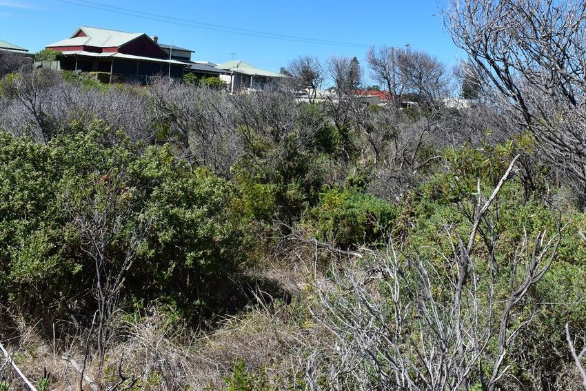
City of Rockingham
Mersey Point Bus Terminus Offset Revegetation Plan

                                                     Natural Area Holdings Pty Ltd © 2021 |Page 8 of 88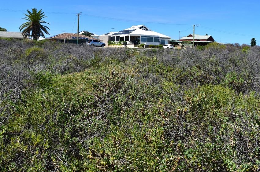
City of Rockingham
Mersey Point Bus Terminus Offset Revegetation Plan
2.0 Site Characteristics
Site characteristics, including soils, vegetation complexes and climate will inform the revegetation plan, as
the aim is to restore vegetation species and condition to the offset areas that are more degraded than the
vegetation within the proposed clearing area. Key characteristics are outlined in this section.
2.1 Regional Context
According to Interim Biogeographical Regionalisation of Australia (IBRA) descriptions, the proposed clearing
and offset sites are located within the Swan Coastal Plain region. This region comprises of two major
divisions, namely Swan Coastal Plain 1- Dandaragan Plateau and Swan Coastal Plain 2- Perth Coastal Plain
(Department of Primary Industry and Regional Development, 2021a).
The sites are located within the Perth Coastal Plain 2 (SWA 2- Swan Coastal Plain subregion) and is described
as a low-lying coastal plain with sands of colluvial and aeolian origin. The region is dominated by Banksia
and/or Jarrah Woodland over sandy soils associated with dune systems, with Paperbark (Melaleuca) in
swampy/dampland areas and Jarrah Woodland to the east where the Swan Coastal Plain rises (Mitchell et al,
2002).
2.2 Climate
The climate experienced in the area is Mediterranean, with dry, hot summers and cool, wet winters.
According to the Bureau of Meteorology (Garden Island, Station ID 009256 2021):
▪ average rainfall is 598 mm pa, with the majority falling between May and August
▪ average maximum temperatures range from 17.9 oC in winter 28.2 oC in summer, with the highest
recorded maximum being 43.4 oC
▪ average minimum temperatures range from 11.2 oC in winter to 19.4 oC in summer, with the lowest
recorded minimum being 3.5 oC
▪ predominant wind directions included morning easterlies and south-westerly sea breezes during
summer months, with an average wind speed of 19.3 km/h and gust of more than 100 km/h.
2.3 Topography and Soils
Site topography ranges from 1 to 2 m Australian Height Datum (AHD) rising from west to east (Department
of Water and Environmental Regulation, 2021). The proposed clearing area is located on the Quindalup Dune
System within the Swan Coastal Plain. This system is characterised by coastal dunes with calcareous deep
sands and tallow sands (DPIRD, 2021b). Two soil types were identified using the Natural Resource
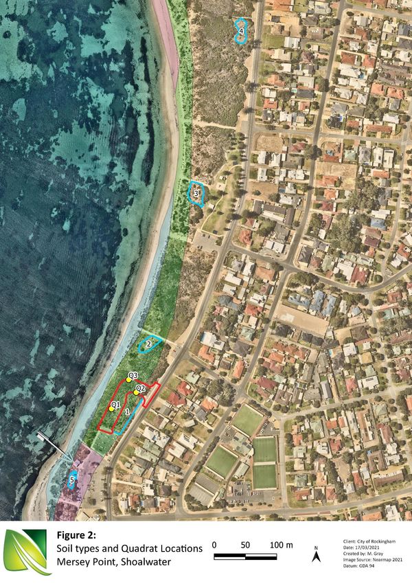
Information Portal (NRInfo) and are described in Table 1 (Figure 2) (DPRID, 2021b).
Natural Area Holdings Pty Ltd © 2021 |Page 9 of 88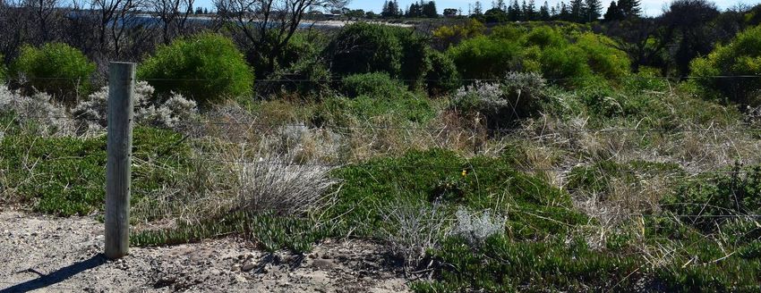
City of Rockingham
Mersey Point Bus Terminus Offset Revegetation Plan

Table 1: Soil types and descriptions
 Name                       Symbol                Description
                                                  Foredune/blowout complexes (semi-erosional) with very
 Quindalup South Qf1
                            211Qu__Qf1            low relief ridge and swale topography with deep uniform
 Phase
                                                  calcareous sands.

 Quindalup South Qf2                              Relict foredunes and gently undulating beach ridge plain
                            211Qu__Qf2
 Phase                                            with deep uniform calcareous sands.

Source: DPIRD, 2021

2.4     Vegetation Complex
The vegetation complex within the proposed clearing area indicated by National Map is the Quindalup
Complex (Department of Biodiversity, Conservation and Attractions, 2021a). This complex is described by
Heddle et. al. (1980) as a low closed forest and shrubland restricted to the coastal dunes. These dunes can
be subdivided into two alliances, namely strand and foredune or the mobile and stable dunes. These
alliances are divided according to changes in vegetation with
     ▪ the strand and fore dune alliance containing species such as
             - Angianthus cunninghamii
             - Arctotheca nivea
             - Atriplex isatidea
     ▪ the mobile and stable dune containing species such as
             - Acacia cyclops
             - Anthocercis littorea
             - Lepidosperma gladiatum
             - Myoporum insulare.

The vegetation differs in its physiognomy and species composition from one place to another due to
variation in dune environment caused by edaphic or topographical factors and the degree of shelter from
salt laden winds (Heddle et. al., 1980).

2.5     Hydrology
According to the NationalMap, no geomorphic wetlands are located within the proposed clearing area or
offset sites, however there are three located within a 5 km buffer (DBCA, 2021b). This includes two small
multiple use wetlands to the east and the conservation category wetland, Lake Richmond to the north-east.

                                                        Natural Area Holdings Pty Ltd © 2021 |Page 10 of 88
City of Rockingham
Mersey Point Bus Terminus Offset Revegetation Plan
Natural Area Holdings Pty Ltd © 2021 |Page 11 of 88City of Rockingham
Mersey Point Bus Terminus Offset Revegetation Plan
3.0 Methodology
3.1 Desktop and Literature Review
Desktop surveys were undertaken to determine:
▪ likely native and non-native flora and fauna species present
▪ current extent of native vegetation
▪ general floristic community types
▪ likely presence of threatened or priority flora and fauna species
▪ likely presence of any threatened or priority ecological communities.
The following databases were accessed to obtain relevant information:
▪ NatureMap (Department of Biodiversity, Conservation and Attractions, 2021e) (Appendix 1)
▪ Protected Matters Search Tool (Department of Agriculture, Water and the Environment, 2021b),
(Appendix 2)
▪ National Map (Australian Government, 2021)
▪ NRInfo (Department of Primary Industries and Regional Development, 2021a)
▪ FloraBase (Department of Biodiversity, Conservation and Attractions, 2021d)
▪ Threatened and priority flora and ecological community database searches (Department of
Biodiversity, Conservation and Attractions, 2021f).
Conservation code definitions for the State and Commonwealth and the data relating to conservation
significant species from database searches were summarised into field reference guides to aid with on-
ground flora surveys (Appendix 3).
3.2 On-ground Flora Survey
Natural Area personnel, Sharon Hynes (Lead Botanist) and Megan Gray surveyed the site on March 9th, 2021,
with key GPS data recorded using Mappt software on a handheld Samsung tablet. The flora and vegetation
surveys were carried out in accordance with EPA Technical Guidance – Flora and Vegetation Surveys for
Environmental Impact Assessment (Environmental Protection Authority, 2016).
Field activities included:
▪ Setting out a total of three 10 m x 10 m quadrats across the one vegetation type present (Figure 2).
A photograph was taken of each quadrat from the north-east corner, with the photo for Quadrat 3
taken from the south-east as the vegetation was too dense to see the quadrat accurately
(Appendix 6).
▪ Walking the site and identifying flora species present within the site and surrounding area, targeting
declared rare and priority species indicated as potentially present during desktop assessments.
▪ Assessing vegetation condition across the site.
▪ Using a GPS to map significant species and boundaries of differing vegetation types and condition.
▪ Determining the presence of any further threatened or priority listed flora species and/or ecological
communities listed under the Biodiversity and Conservation Act 2016 (WA) and/or the Environment
Protection and Biodiversity Conservation Act 1999 (Commonwealth).
▪ Identifying potential offset sites with a similar vegetation type and lower vegetation condition than
that of the proposed clearing area, which can therefore be enhanced to match the clearing area.
Natural Area Holdings Pty Ltd © 2021 |Page 12 of 88City of Rockingham
Mersey Point Bus Terminus Offset Revegetation Plan
Samples were collected and any unfamiliar species were recorded and photographed to enable later
identification. A photo was taken of each quadrat. The following data was collected using a modified
recording sheet based on the NAIA templates developed for the Perth Biodiversity Project:
1. Vegetation type, which was determined using the structural classes described in Bush Forever
Volume 2 (Government of Western Australia, 2000), which records dominant over, middle and
understorey species. A tablet device equipped with GPS mapping software was used to mark the
change in vegetation type across the site. A description of the various structural classes is provided
in Table 3.
2. Vegetation condition was assessed using the rating scale attributed to Keighery in Bush Forever
Volume 2 (Government of Western Australia, 2000) (Table 4).
3. Aspect of the site.
4. Topography of the site.
5. Slope of the site.
6. Soil type.
7. Soil colour.
8. Gravel as a percentage of cover.
9. Rock as a percentage of cover.
10. Leaf litter as a percentage of cover.
11. Bare ground as a percentage of cover.
12. Drainage of the site.
13. Flora species present including percentage cover, height, habit and life form. Where species could
not be identified in the field, samples were collected, or photographs taken for later identification.
Additional species were recorded whilst the site was being traversed. Conservation significant
species were targeted using the field reference guide compiled from the results of database
searches.
14. Fauna sightings or evidence of fauna use within the sites.
3.2.1 Vegetation Type
The vegetation type was determined using the structural classes described in Bush Forever Volume 2
(Government of Western Australia, 2000), which records dominant over, middle and understorey species
(Table 2).
Table 2: Vegetation structural classes
Life Form/Height Canopy Percentage Cover
Class 100 – 70% 70 – 30% 30 – 10% 10 – 2 %
Trees over 30 m Tall closed forest Tall open forest Tall woodland Tall open woodland
Trees 10 – 30 m Closed forest Open forest Woodland Open woodland
Trees under 10 m Low closed forest Low open forest Low woodland Low open woodland
Closed tree
Tree Mallee Tree mallee Open tree mallee Very open tree mallee
mallee
Natural Area Holdings Pty Ltd © 2021 |Page 13 of 88City of Rockingham
Mersey Point Bus Terminus Offset Revegetation Plan
Life Form/Height Canopy Percentage Cover
Class 100 – 70% 70 – 30% 30 – 10% 10 – 2 %
Closed shrub Open shrub Very open shrub
Shrub Mallee Shrub mallee
mallee mallee mallee
Shrubs over 2 m Closed tall scrub Tall open scrub Tall shrubland Tall open shrubland
Shrubs 1 – 2 m Closed heath Open heath Shrubland Open shrubland
Shrubs under 1 m Closed low heath Open low heath Low shrubland Low open shrubland
Grasses Closed grassland Grassland Open grassland Very open grassland
Herbs Closed herbland Herbland Open herbland Very open herbland
Sedges Closed sedgeland Sedgeland Open sedgeland Very open sedgeland
(Source: Government of Western Australia, 2000)
3.2.2 Vegetation Condition
Vegetation condition was assessed using the rating scale attributed to Keighery in Bush Forever Volume 2
(Table 3) (Government of Western Australia, 2000).
Table 3: Vegetation condition ratings
Category Description
1 Pristine Pristine or nearly so, no obvious signs of disturbance.
2 Excellent Vegetation structure intact, disturbance affecting individual species and weeds are
non-aggressive species.
3 Very Good Vegetation structure altered, obvious signs of disturbance. For example, disturbance
to vegetation structure caused by repeated fires, the presence of some more
aggressive weeds, dieback, logging and grazing.
4 Good Vegetation structure significantly altered by very obvious signs of multiple
disturbances. Retains basic vegetation structure or ability to regenerate it. For
example, disturbance to vegetation structure caused by very frequent fires, the
presence of some very aggressive weeds at high density, partial clearing, dieback and
grazing.
5 Degraded Basic vegetation structure severely impacted by disturbance. Scope for regeneration
but not to a state approaching good condition without intensive management. For
example, disturbance to vegetation structure caused by very frequent fires, the
presence of very aggressive weeds, partial clearing, dieback and grazing.
6 Completely The structure of the vegetation is no longer intact, and the area is completely or
Degraded almost completely without native species. These areas are often described as
‘parkland cleared’ with the flora comprising weed or crop species with isolated native
trees or shrubs.
(Source: Government of Western Australia, 2000)
Natural Area Holdings Pty Ltd © 2021 |Page 14 of 88City of Rockingham
Mersey Point Bus Terminus Offset Revegetation Plan
3.3 Limitations
Several limitations associated with both desktop and on-ground flora surveys exist, including:
▪ database searches provide an indication of what flora species may be present, with on ground
surveys required to confirm those present
▪ information on flora species provided on some databases include out-of-date species names,
meaning that names need to be checked for currency
▪ herbarium records are largely limited to vouchered specimens
▪ plant species flower at different times and are not always able to be identified
▪ on-ground surveys indicate species present at the time of the assessment, with species flowering at
different times not always able to be identified
▪ not all species flower every year
▪ the differing databases are reliant on information submitted via various reporting mechanisms, so all
records of a particular species or ecological community within a specified area may not be complete
▪ survey was conducted outside of spring, optimum time; therefore, annuals that occur during spring
would not have been present during the survey.
Despite these limitations, Natural Area estimates that 80 – 90% of flora species within the survey area were
identified.
Natural Area Holdings Pty Ltd © 2021 |Page 15 of 88City of Rockingham
Mersey Point Bus Terminus Offset Revegetation Plan
4.0 Results
4.1 Desktop Survey
A review of NatureMap identified a total of 253 flora and 376 fauna species which could potentially occur
within a 5 km radius of the proposed clearing area including:
▪ 175 dicots
▪ 78 monocots
▪ 6 amphibians
▪ 189 birds
▪ 123 fish
▪ 19 mammals
▪ 39 reptiles.
4.1.1 Significant Flora
A review of NatureMap indicated two conservation significant flora species listed under the Biodiversity
Conservation Act 2016 (WA), as potentially occurring within 5 km of the proposed clearing area (DBCA,
2021c). A review of the Protected Matters Search Tool (PMST) indicated one significant flora species listed
under the Environment Protection and Biodiversity Conservation Act 1999 (EPBC Act) (Cwlth) as potentially
occurring within a 5 km radius of the site (DAWE, 2021). Flora species potentially occurring are listed in Table
5, with conservation code descriptions provided in Appendix 3.
A review of the DBCA threatened and priority flora database indicated two priority species have the
potential to be recorded within 5 km of the site (DBCA, 2021e). Of the conservation significant species
potentially found in the area, it was determined that the site conditions (soil type, drainage, location) may
be suitable for one of these species; Dodonaea hackettiana (Table 5). Conservation code descriptions are
provided in Appendix 3.
Table 5: Threatened and Priority flora species listed by NatureMap, PMST and DBCA
Species Name Cons. Code Nature Map PMST DBCA
Diuris micrantha VU X
Dodonaea hackettiana P4 X X
Sphaerolobium calcicola P3 X X
4.1.2 Threatened Ecological Communities
A review of the PMST report identified four listed Threatened Ecological Communities that could potential
occur within 5 km of the site (Table 6) (DAWE, 2021). A review of the DBCA database confirmed that the
proposed clearing site falls within a 5 km buffer of five known TECs, with one community of Thrombolite
(microbial) community of coastal freshwater lakes of the Swan Coastal Plain (Lake Richmond) and four
communities of Sedgelands in Holocene dune swales of the southern Swan Coastal Plain (DBCA, 2021e).
Natural Area Holdings Pty Ltd © 2021 |Page 16 of 88City of Rockingham
Mersey Point Bus Terminus Offset Revegetation Plan
Table 6: Potential Threatened Ecological Communities within the site.
Name Status Presence
Community known to occur within the
Banksia Woodlands of the Swan Coastal
Endangered area. Unlikely to occur, habitat and soil
Plain ecological community
unsuitable
Sedgelands in Holocene dune swales of
Endangered Community known to occur within area.
the southern Swan Coastal Plain
Thrombolite (microbial) community of
Community known to occur in the area.
coastal freshwater lakes of the Swan Endangered
Unlikely to occur, habitat unsuitable
Coastal Plain (Lake Richmond)
Tuart (Eucalyptus gomphocephala)
Critically Community known to occur within the
Woodlands and Forests of the Swan
Endangered area.
Coastal Plain
4.1.3 Significant Fauna
A review of NatureMap indicated five conservation significant fauna species listed under the Biodiversity
Conservation Act 2016 (WA), potentially occurring within 5 km of the site (DBCA, 2021a). A review of the
Protected Matters Search Tool (PMST) (DAWE, 2021) indicated three significant fauna species listed under
the Environment Protection and Biodiversity Conservation Act 1999 (EPBC Act) (Cwlth) as potentially
occurring within a 5 km radius of the site. Fauna species potentially occurring are listed in Table 7.
Conservation Code descriptions are provided in Appendix 3. Database search result listed potentially
occurring species including marine and transient bird species. These have not been included as they would
not occur within the actual clearing area or would not be affected by clearing activities, as there is no
primary habitat present for these species.
A review of the DBCA threatened and priority fauna database indicated five priority species have the
potential to be recorded within 5 km of the site (DBCA, 2021e). Of the conservation significant species
potentially found in the area, it was determined that the site conditions (habitat, vegetation, location) may
be suitable for two of these species (highlighted green; Table 5).
Table 7: Threatened and Priority fauna listed by NatureMap, PMST and DBCA
Cons. Nature
Species Name Common Name PMST DBCA
Code Map
Bettongia penicillata ogilbyi Woylie EN X
Dasyurus geoffroii Chuditch VU X
Swan Coastal Plain Shield-backed
Idiosoma sigillatum P3 X X
Trapdoor Spider
Quenda, Southwestern Brown
Isoodon fusciventer P4 X X
Bandicoot
Lerista lineata Perth Slider, Lined Skink P3 X X
Neelaps calonotos Black-Striped Burrowing Snake P3 X X
Natural Area Holdings Pty Ltd © 2021 |Page 17 of 88City of Rockingham
Mersey Point Bus Terminus Offset Revegetation Plan
Cons. Nature
Species Name Common Name PMST DBCA
Code Map
Phascogale tapoatafa subsp. South-western Brush-tailed
CD / S X X
wambenger Phascogale
Pseudocheirus occidentalis Western Ringtail Possum CR X
4.2 Survey Results – Mersey Point Bus Terminus Site
4.2.1 Flora
A total of 26 flora species from 16 families were recorded within the site. Of these, 14 were introduced
species and 12 were native species. Examples of native flora species recorded are shown in Figure 3, with
introduced species shown in Figure 4. A complete flora list is provided in Appendix 4.
4.2.2 Vegetation Type
One vegetation type was recorded within the proposed Mersey Point Site, namely Acacia rostellifera
Shrubland. With no overstory vegetation, a dense middle story of Acacia rostellifera, Rhagodia baccata and
Tetragonia decumbens*, with an understory that consists of weedy grasses, primarily Wimmera Ryegrass
(Lolium rigidum) and Great Brome (Bromus diandrus). Full species list and quadrat photos are provided in
Appendix 6.
4.2.3 Threatened and Priority Ecological Communities
No threatened or priority ecological communities were recorded within the proposed Mersey Bus Terminus
clearing area. The survey determined that no coastal freshwater lakes, Banksia species or Eucalyptus
gomphocephala were present within the proposed clearing area and therefore their subsequent
communities were not present.
The Department of Environment and Conservation Species and Community Branch (2011) provides a
description of the key characteristics of the TEC, Sedgelands of the Holocene dune swales of the southern
Swan Coastal Plain. Summarised as occurring in damplands or sumplands that are waterlogged throughout
winter and retain high moisture in surface soil in summer, with the presence of typical and common native
species including:
▪ Acacia rostellifera
▪ Acacia saligna
▪ Xanthorrhoea preissii
▪ Baumea juncea
▪ Ficinia nodosa
▪ Lepidosperma gladiatum
▪ Poa porphyroclados.
The vegetation and floristic survey did not identify this community or any other PEC or TEC within the
proposed clearing area. Although the species A. rostellifera and F. nodosa (planted) were identified they are
not considered to be within sedgeland vegetation type. Furthermore, the quadrat survey identified the area
as having well-draining sand.
Natural Area Holdings Pty Ltd © 2021 |Page 18 of 88City of Rockingham
Mersey Point Bus Terminus Offset Revegetation Plan
4.2.4 Vegetation Condition
The current vegetation condition is Good across the entire proposed clearing area, with no native overstory
a dense native and weedy middle story of Acacia rostellifera, Rhagodia baccata and Tetragonia decumbens*
and a weedy understory of introduced grasses.
4.2.5 Fauna
A total of two fauna species were observed within the proposed clearing site, namely the Willie Wagtail
(Rhipidura leucophrys) and Laughing Turtle Dove (Spilopelia senegalensis). These species are common
throughout in the Perth Region and seem to thrive in urban and disturbed habitats.
Natural Area Holdings Pty Ltd © 2021 |Page 19 of 88City of Rockingham
Mersey Point Bus Terminus Offset Revegetation Plan
Olearia axillaris (Coastal Daisybush) Spyridium globulosum (Basket Bush) Rhagodia baccata (Berry Saltbush)
Clematis linearifolia Alyxia buxifolia (Dysentery Bush) Spinifex longifolius (Beach Spinifex)
Figure 3: Examples of native flora species recorded
Natural Area Holdings Pty Ltd © 2021 |Page 20 of 88City of Rockingham
Mersey Point Bus Terminus Offset Revegetation Plan
Great Brome (*Bromus diandrus) Sea Spinach (*Tetragonia decumbens) Lesser Dodder (*Cuscuta epithymum)
Gazania (*Gazania linearis) Dune Onion Weed (*Trachyandra divaricata) Rose Pelargonium (*Pelargonium capitatum)
Figure 4: Examples of introduced (weed) species recorded
Natural Area Holdings Pty Ltd © 2021 |Page 21 of 88City of Rockingham
Mersey Point Bus Terminus Offset Revegetation Plan
Natural Area Holdings Pty Ltd © 2021 |Page 22 of 88City of Rockingham
Mersey Point Bus Terminus Offset Revegetation Plan
Natural Area Holdings Pty Ltd © 2021 |Page 23 of 88City of Rockingham
Mersey Point Bus Terminus Offset Revegetation Plan
4.3 Survey Results – Offset Sites
The five proposed offset sites were chosen based on vegetation condition and similarities in vegetation
composition to the proposed clearing area.
4.3.1 Flora
Common weed species throughout all offset sites was Sea Spinach (Tetragonia decumbens*) and Great
Brome (Bromus diandrus*). Tuart (Eucalyptus gomphocephala) was in close proximity to Offset Site 4. A flora
list for the proposed offset sites is provided in Appendix 5.
4.3.2 Vegetation Type
The vegetation type of Acacia rostellifera was recorded at the proposed clearing site and all five of the
proposed offset sites with differing vegetation condition. Many sites have remnant species from previous
rehabilitation efforts and would require a range of infill efforts to enhance vegetation condition and
composition. A description of the vegetation types of each offset site is listed in Table 8.
Table 8: Vegetation type and description of each proposed offset site
Offset Site Vegetation Type and
Photo
No. Description
Acacia rostellifera Shrubland
Sparse midstory of Acacia
Offset Site
rostellifera over Tetragonia
1
decumbens* and an
understory of mixed weedy
grasses and herbs.
Acacia rostellifera Shrubland
Sparse to no midstory of
Offset Site
Acacia rostellifera over
2
Spinifex longifolia and
Tetragonia decumbens* and
weedy grass understory.
Natural Area Holdings Pty Ltd © 2021 |Page 24 of 88City of Rockingham
Mersey Point Bus Terminus Offset Revegetation Plan
Offset Site Vegetation Type and
Photo
No. Description
Acacia rostellifera Shrubland
Previous restoration site.
Offset Site
Sparse midstory of Acacia
3
rostellifera over mixed
shrubs and an understory of
*Trachyandra divaricata.
Acacia rostellifera Shrubland
Previous restoration site.
Sparse midstory of Acacia
Offset Site rostellifera over mixed
4 shrubs and an understory of
mixed weedy grasses and
herbs. Presence of
Eucalyptus gomphocephala
nearby.
Acacia rostellifera Shrubland
Previous restoration site.
Completely Degraded.
Offset Site
Surrounding vegetation
5
sparse to no midstory of
Acacia rostellifera over
mixed planted shrubs with
no understory.
4.3.3 Threatened Ecological Communities
No threatened or priority ecological communities were recorded within the five offset sites. The survey
determined that no coastal freshwater lakes, Banksia species or sedges were present within the offset sites,
therefore subsequent communities were not present.
The Department of Agriculture, Water and the Environment (2019) provides a description of the key
characteristics of the TEC, Tuart (Eucalyptus gomphocephala) Woodlands and Forests of the Swan Coastal
Plain. Primarily occurring within the Spearwood and Quindalup dune system the defining feature is the
Natural Area Holdings Pty Ltd © 2021 |Page 25 of 88City of Rockingham
Mersey Point Bus Terminus Offset Revegetation Plan
presence of at least two living Tuart trees in the upper canopy layer, with a gap of no more than 60 m
between their canopies.
Offset Site 4 identified two individual Tuart trees that were in the upper canopy layer with approximately
100 m distance between canopies (Figure 6). Due to this difference to key characteristics the area is not
considered to be within a TEC. However, by including Tuart into the species mix of Offset Site 4, it will
provide the potential for restoration of the Tuart (Eucalyptus gomphocephala) Woodlands and Forests of the
Swan Coastal Plain community in this location.
4.3.4 Vegetation Condition
Vegetation condition within offset sites ranged from Good to Completely Degraded. All but one offset site
had a vegetation condition of Degraded, with Offset Site 1 having a small portion of vegetation that was of
Good condition (Table 9 and Figure 5.1 & 5.2). The offset sites make up a combined area of 0.326 ha, with
the smallest site, Offset Site 5 also being completely degraded covering 0.020 ha (Table 9).
Table 9: Vegetation Condition of the proposed Offset Sites.
Site Vegetation Condition Area (ha) Percentage Cover %
Good 0.022 82.9
Offset 1
Degraded 0.107 17.1
Offset 2 Degraded 0.053 100
Offset 3 Degraded 0.072 100
Offset 4 Degraded 0.051 100
Offset 5 Completely Degraded 0.020 100
Total Area (ha) 0.326
4.3.5 Fauna
Two fauna species, Ctenotus fallens and the European Rabbit (Oryctolagus cuniculus) were observed through
observation and presence indicators. With the European Rabbit listed as a C3 declared pest on the Western
Australian Organism List under the Biosecurity and Agriculture Management Act 2007 (WA).
Natural Area Holdings Pty Ltd © 2021 |Page 26 of 88City of Rockingham
Mersey Point Bus Terminus Offset Revegetation Plan
Natural Area Holdings Pty Ltd © 2021 |Page 27 of 88City of Rockingham
Mersey Point Bus Terminus Offset Revegetation Plan
5.0 Revegetation Plan Objectives
5.1 Revegetation Requirements
Clearing vegetation in Western Australia is regulated under Part V Division 2 of the EP Act and the
Environmental Protection (Clearing of Native Vegetation) Regulations 2004 (Clearing Regulations).
Revegetation plans are required to outline the establishment and maintenance of the revegetation of offset
areas that have been selected due to a clearing permit approval. The EP Act states that the plan must include
a completion criterion that outlines the monitoring, reporting and assessment of the effectiveness of
revegetation efforts until expiry of the clearing permit.
5.2 Revegetation Aims
The aim of the revegetation activities within the offset sites are to:
▪ restore the sites to self-sustaining ecosystems that extend into the existing areas of vegetation
▪ restore understory cover and increase species diversity
▪ remove competition on native flora due to presence of invasive species.
Natural Area Holdings Pty Ltd © 2021 |Page 28 of 88City of Rockingham
Mersey Point Bus Terminus Offset Revegetation Plan
6.0 Revegetation Plan
The major aim of the revegetation plan is to reintroduce native middle and understory species into the area
that will result in a similar vegetative type and structure to the existing vegetation across the dune system of
Shoalwater Beach.
The restoration activities will occur over a five year period from site preparation works, installation and plant
establishment and five years’ of post-installation monitoring and maintenance. The plan focusses on the
planting of native understory species along with a small number of middle to upper storey species to
increase vegetation cover. The flora and vegetation assessment carried out by Natural Area identified
species that could be used for planting.
Plan development has included the following activities:
▪ identification of flora species within the offset site and nearby vegetated areas, including native and
weed species
▪ assessment of vegetation condition
▪ the presence of waste materials, and pests that could reduce the success of rehabilitation outcomes
▪ development of success and monitoring criteria to be implemented after the initial installation of
tubestock.
6.1 Site Preparation
Site preparation ahead of revegetation works will include:
▪ weed control
▪ pest animal control, if required
▪ removal of rubbish
▪ installation of fencing or other suitable barrier to delineate the revegetation areas from formalised
paths and structures and to prevent trampling by the public.
No soil preparation activities, such as ripping, are required for the sandy soils present in the offset areas,
noting that the presence of limestone may be encountered in some locations. The use of mechanical augers
or other planting equipment may be required to assist with planting.
6.1.1 Weed Control
Consideration should be given to the use of herbicides in bushland and wetland areas through permitted off-
label use by the Australian Pesticides and Veterinary Medicines Authority (APVMA). It is recommended that
herbicides such as Metsulfuron and Triasulfuron be used at the recommended dose and in a targeted
fashion within the site to reduce their potential residual effect in soils. Recommended weed treatments and
treatment times are outlined in Table 9 (DBCA, 2021b; Brown and Brooks, 2002). Weeds recorded on site
and their specific weed control methodologies are shown in Table 10.
Natural Area Holdings Pty Ltd © 2021 |Page 29 of 88City of Rockingham
Mersey Point Bus Terminus Offset Revegetation Plan
Table 10: Weed Treatment types, target species and methodology
Treatment Application Method and
Treatment Type Targeted Species
Number Comments
Annual and perennial
Glyphosate spray (non-
1 grass and broadleaf Spot spray target species
selective)
weeds
Selective grass herbicide Annual and perennial Spot spray - selective grass spray
2
(Quizalofop or Fusilade) grasses (will affect native grass species)
Annual broadleaf weeds
3 Metsulfuron Spot spray – semi selective
and bulbs
Glyphosate glove/sponge Wipe leaves with sponge prior to
4 One-leaf Cape Tulip
wipe or just on flowering
Cut and paint or drill and fill
Triclopyr, Picloram, or (Method is species dependant as
5 Woody weeds and trees
Glyphosate some are prone to suckering e.g.
Japanese Pepper, Olives)
Carnation weeds
(Euphorbia sp.), Fleabane
Manual removal/hand (Conyza sp.) and other Gloves required due to caustic sap
6
weeding similar species including of Carnation weeds
woody weed seedlings
when small
Carnation weed
(Euphorbia sp.),
7 Triasulfuron Brassicaceae weeds Spot spray – selective
post emergence and
other annual species
Source: DBCA, 2021b
A weed prioritisation rating system has been developed by the Department of Biodiversity, Conservation and
Attractions (DBCA) (2019) to determine priority for control of weed species based on their ecological impact
in the Swan Region. Weed species noted on site are listed in Table 11, with different management categories
for control assigned under the Biosecurity and Agriculture Management Regulations 2013 (WA) according to
their invasiveness and environmental impact. These species should be the focus of weed control activities
within the revegetation areas, followed by lower priority species.
Natural Area Holdings Pty Ltd © 2021 |Page 30 of 88City of Rockingham
Mersey Point Bus Terminus Offset Revegetation Plan
Table 11: Weed control methodology
Species Name Common Name Treatment No. Timing
High Impact
Avena barbata Bearded Oat 2 Jul - Oct
Bromus diandrus Great Brome 1 and/or 2 Jun - Aug
Carpobrotus edulis Hottentot Fig 1 and/or 6 Jun - Oct
Cynodon dactylon Couch 1 and/or 2 Nov - Feb
Euphorbia terracina Geraldton Carnation Weed 6, Logran Jun - Aug
Gazania linearis Gazania 1 Aug - Dec
Lagurus ovatus Hare's Tail Grass 2 and/or 6 Jun - Sep
Lolium rigidum Wimmera Ryegrass 1, 2 and/or 6 Jun - Oct
Pelargonium capitatum Rose Pelargonium 3 and/or 6 Jun - Oct
Year
Schinus terebinthifolia Brazilian Pepper 5
Round
Tetragonia decumbens Sea Spinach 1 and 6 Mar - Nov
Medium Impact
Cuscuta epithymum Lesser Dodder 1 Jun - Oct
1 (+chlorsulfuron),
Trachyandra divaricata Dune Onion Weed Jun - Aug
4 and/or 6
Low Impact
Erigeron bonariensis Flaxleaf Fleabane 1 Sep - May
Natural Area Holdings Pty Ltd © 2021 |Page 31 of 88City of Rockingham
Mersey Point Bus Terminus Offset Revegetation Plan
6.1.2 Pest Animal Control
European Rabbit
Rabbits are a highly invasive species due to their ability to reach sexual maturity in a short period of time,
their short gestation period and ability to cope with environmental variability. The direct and indirect effects
of rabbits pose a threat to the ecology of local areas and the viability of rehabilitation activities as they
browse on young plants and tubestock due to their high palatability and nutrient content. The grazing
activities of rabbits often alter the ecology of plant communities by selecting species that are resistant to
regular cropping such as grasses and reducing natural regeneration. Rabbits also have the potential to
exacerbate erosion, promote weed growth as well as competing for resources with native fauna. An indirect
effect of rabbit populations is to provide an increased food supply to introduced predators which in turn
predate native fauna (Pech and Hood, 1998).
Signs of the European Rabbit (Oryctolagus cuniculus) were observed on site in the form of scats within Offset
Site 5 (Figure 7). As this species is highly active it is likely to be present throughout the dune system. The
European Rabbit is listed as a C3 declared pest on the Western Australian Organism List (WAOL) under the
Biosecurity and Agriculture Management Act 2007 (WA), this classification requires management by the
landowner/manager to reduce the impact and spread of the species.
Due to the proximity of the offset sites to a known dog beach (Shoalwater Beach), the use of baiting such as
1080 cannot be used for the control of rabbits as the potential to adversely affect domestic animals is likely.
Installation of tree guards will be required to provide a barrier that will assist with allowing tubestock to
become established. Trapping of rabbits can be considered as an alternative control measure, however this
will need to be undertaken in conjunction with trapping of the larger foreshore reserve to make an effective
difference.
6.1.3 Rubbish Removal
Rubbish within the sites was limited to items such as wrappers, napkins that were windblown into
vegetation due to the proximity of facilities such as the Pengos Café, Recreational Parkland Areas and
Residential Housing (Figure 1). Other miscellaneous items such as a garden lattice was found within the
clearing site (Figure 7). Rubbish removal is recommended prior to revegetation works and during
maintenance activities.
Natural Area Holdings Pty Ltd © 2021 |Page 32 of 88You can also read