CLAPHAM
NEIGHBOURHOOD
    PLAN
     2030
←
→
Page content transcription
If your browser does not render page correctly, please read the page content below
CLAPHAM
NEIGHBOURHOOD
PLAN
2030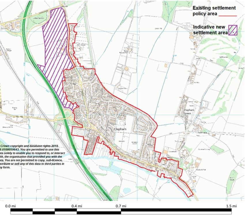
Clapham Neighbourhood Plan

Foreword

Clapham’s Neighbourhood Plan was led by the Neighbourhood Plan Group made up of
residents and Parish Councillors. The Group wanted the residents of Clapham to have a say
in all aspects of the future of the village but most importantly it wanted local people to decide
where new housing should be built, rather than leaving this decision to Bedford Borough
Council. The Plan sets aims on key themes such as housing, business development, green
space and village assets so that the village can grow in a sustainable way ensuring that
Clapham remains a rural village and key services and infrastructure are not overstretched.
The Neighbourhood Plan Group would like to thank everyone for their contribution to the
Plan.

                                               1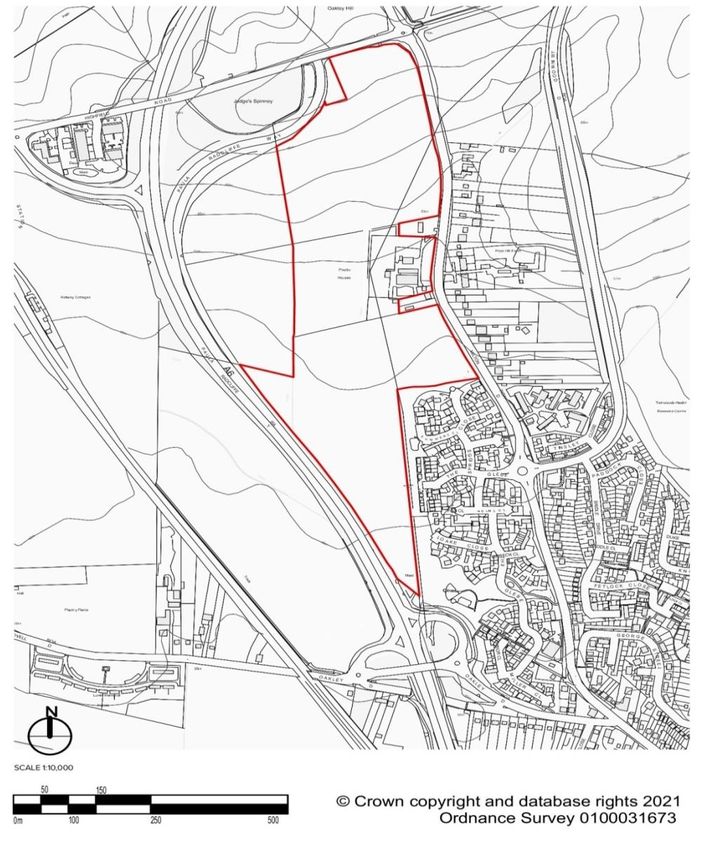
Index

Section Topic                                                Page
1.        Introduction ………………………………………………………………….               3
2.        Basic Conditions ………………………………………………………….….            3
3.        Neighbourhood Area ……………………………………………….………..           4
4.        Location and History …………………………………………………….…..         5
5.        Sustainable Development ……………………………………………………         10
6.        Vision …………………………………………………………………….….                 13
7.        Aims …………………………………………………………………………                    13
8.        Evidence ……………………………………………………………………..                14
9 – 12.   Policies ………………………………………………………………………                 15
13.       Settlement Policy Area ………………………………………………………         44
14.       Plan Monitoring and Review ………………………………………………...     44
          Maps …………………………………………………………………………
                1.   Clapham Neighbourhood Area                 4
                2.   Allocated Site (Milton Hill)              24
                3.   Location of Community Centre              28
                4.   Allocated Site Community Centre           29
                5.   Traffic Pressure Points                   41
                6.   Policy Map                                44

                                               2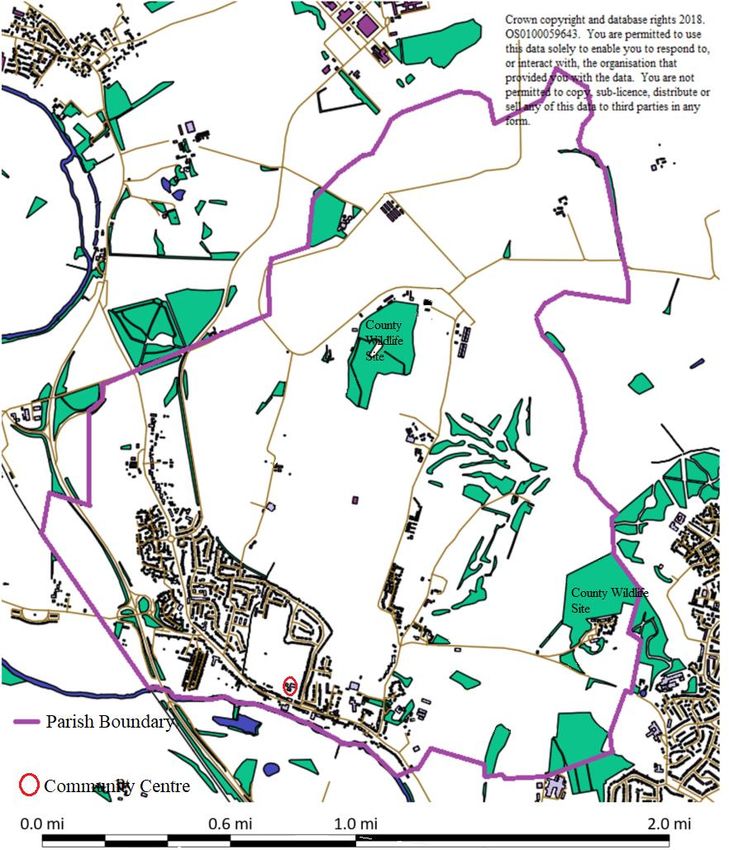
1. Introduction

1.1. The 2012 Localism Act enabled the creation of Neighbourhood Plans and the Clapham
Neighbourhood Plan contains the policies residents want for the development of the village
up to 2030. The Plan was begun in 2013 and is based on evidence of planning requirements
and local need. Technical assessments and consultation with residents, businesses and local
organisations were undertaken and the Plan has been modified where appropriate in response
to these. The Neighbourhood Plan has given residents the opportunity to allocate a site or
sites where new housing should be built. Without a Neighbourhood Plan, Bedford Borough
Council would make these decision on behalf of the people of Clapham.

1.2. Once “made”, a Neighbourhood Plan forms part of the statutory development plan for the
area, together with the Borough Local Plan. The Neighbourhood Plan will be reviewed every
five years

Basic Conditions

2.1. Neighbourhood Plans must meet the “basic conditions” outlined in the Town and
Country Planning Act 1990 to ensure plans contribute to the achievement of sustainable
development, have regard to national policy and guidance, are in general conformity with
adopted strategic local planning policies and do not breach EU obligations. The current
Bedford Borough Local Plan 2030 was adopted on 15th January 2020 and requires Clapham
to allocate 500 new homes by 2030.

2.2. Although deciding where new housing should go is an important part of the Plan, it is a
plan for the village as a whole. The Plan considers a wide range of issues, including:

■ appropriate siting for the proposed new Community Centre

■ protecting green spaces and public access to the river

■ minimising CO2 emissions and encouraging biodiversity

■ protecting, and where appropriate, enhancing the significance of heritage assets of
architectural, archaeological and historic interest

■ maintaining and supporting business

2.3. This Plan is divided into sections and sections 9 to 12 set out the policies for Clapham
and how they will be delivered. There is a large amount of background information that has
helped in producing the Plan (the ‘Evidence Base’). Supporting documents are available on
the Parish Council’s website – www.clapham-pc.gov.uk

                                               3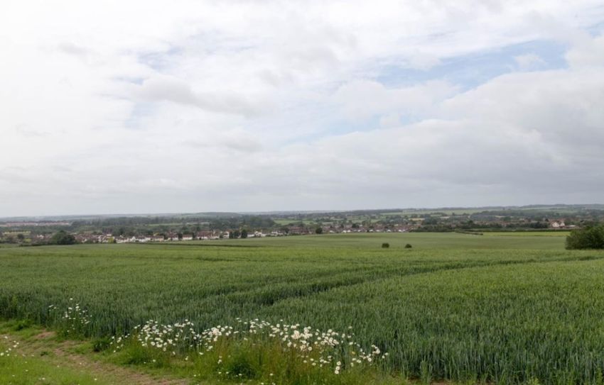
3. Neighbourhood Area

3.1. Bedford Borough Council designated the area shown below as ‘Clapham Neighbourhood
Area’ on 1st July 2013.

                        Map 1 – Clapham Neighbourhood Area

                                          4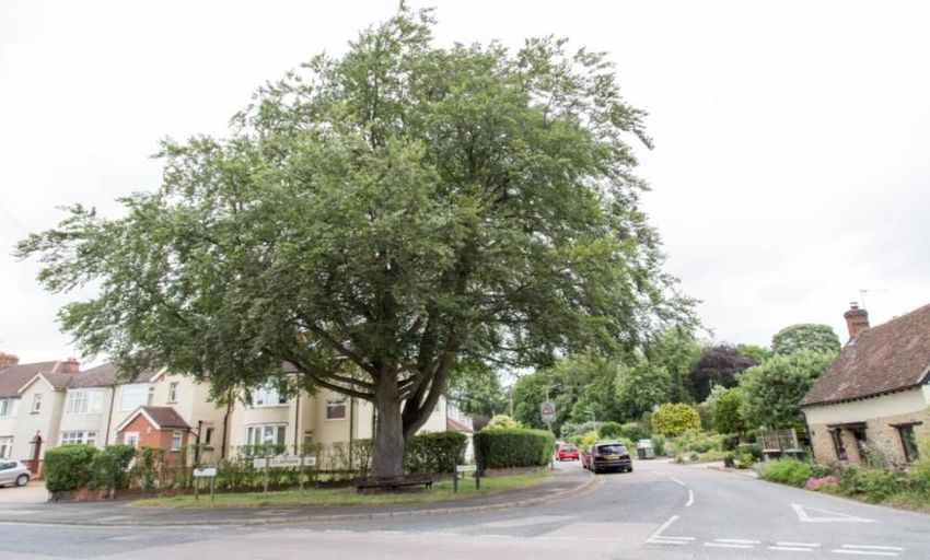
4. Location & History

4.1. Clapham is a large village on the bank of the river Great Ouse approximately 6.5 km (4
miles) north of Bedford and has been an agricultural village since before the Norman
Conquest. The Parish extends to approximately 8 km2 and the village of Clapham lies
towards the southern end of the parish. The village is surrounded by fields and woodlands,
which create a buffer between Bedford and neighbouring settlements. Bromham (10 km) and
Oakley (2 km) lie south and west of Clapham respectively with the A6 forming a gap
between the settlements. Milton Ernest (4km) and Thurleigh (9km) both lie north separated
by a large area of the rural part of Clapham.

                        Clapham Parish Church (Grade I listed)

4.2. The Manor of Clapham can be traced back to the 10th century, even before the
Domesday Book of 1086. The Domesday survey recorded a total population of around 150
residents indicating that Clapham was a large settlement even then. Clapham Manor and the
adjoining farmhouse came into the possession of Ramsey Abbey in 998 and the Saxon church
tower was used to look out for raiders who came up the river as far as The Ford. During the
17th century the Taylor family owned the manor and it was Ursula Taylor who founded the
charity which bears her name. Apart from the church, Clapham Park Farmhouse is the oldest
remaining building in the village and is grade II listed.

4.3. During the 18th century, any horse-drawn coaches passing though the village had to pay
tolls at the tollgate, now known as Woodlands Cottage, which stands just off Green Lane, to
the north of The Ford. A nearby coaching inn, the Horse and Jockey (now the Horse and
Groom) offered accommodation to the coachmen and passengers. The building is now Grade
II listed.

                                            5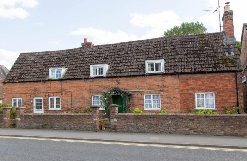
4.4. The 19th century history of the village is illustrated by the surviving buildings and
terraces on the High Street and The Warren. The Warren is now cottages however, it was
formerly walled in as a rabbit warren by the lord of the manor. Clapham Park, a
large country house, was built by James Howard, the Member of Parliament for Bedford in
1872.

4.5. Today Clapham is a mixture of housing, small shops & businesses and leisure facilities
including a large allotment site, public gardens, and a King George V Playing Field. The
village has a primary school and a Pre-School. Twinwood Airfield, a disused airfield on the
outskirts of the village, is where the famous bandleader Glenn Miller took off on his last
flight and the Glenn Miller Museum is now open on the site. There is also a derelict, former
army camp, now owned by a local farmer.

4.6. The village is linear running from south-east to north-west and bounded by the river and
railway to the south-west, farmland to the north & east and Bedford to the south. Housing in
Clapham comprises a mix of styles and periods. Most of the houses in the village are two
storeys with the exception of three storey dwellings on The Glebe estate and The Lodge
retirement homes. There are also housing association flats at Princess Street, The Close and
Bents Close, some bungalows and two mobile home sites.

4.7. The edges of the village comprise a mix of old and new mainly detached properties with
large gardens. In the centre of the village dwellings are older Victorian terraces and cottages
and many front directly onto the road with no off-street parking.

 Terraced house steeply pitched slate roof with original dormer windows, High Street

                              © 2018 AECOM Limited. All Rights Reserved.

This building is timber framed and probably the only unlisted pre-19th century timber framed
building in the parish.
4.8. Following the First World War, in the 1930s, development started on the western side of
the village, to the west of The Warren, including The Close and Highbury Grove. The new
residential development had a suburban style with spacious rear gardens and small front
gardens. The buildings were mainly one or two storeys with pitched or hipped roofs and

                                                  6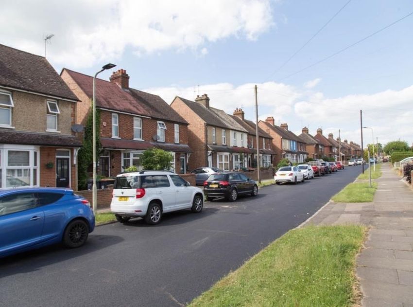
casement windows. The Mount Pleasant Road loop around the Playing Field/Village Hall is
predominantly semi-detached dwellings, mostly built in the 1950s.

                            Post war housing, Highbury Grove

                              © 2018 AECOM Limited. All Rights Reserved.

4.9. To the north-east the “horse” estate, is a mixed development of approximately 200
dwellings, including affordable housing, built in the 1960s. To the north-west is The Glebe, a
modern mixed development of around 300 properties built in the 1990s, including affordable
housing and the Medical Centre. Houses on The Glebe are “national” styles common of
volume house buildings and are generally at a higher density than in the rest of Clapham
creating a more enclosed feel. Some houses that are 2.5 storeys in height have dormer
windows, not reflective of the scale and form of historic development in the village. In recent
years two small new developments have been built off the High Street.

4.10. Buildings throughout the village are predominantly brick or brick and render,
interspersed with older statement buildings such as the Horse & Groom & Star public houses
and the Parish and Methodist churches and commercial premises such as the Post Office,
garages, the shopping parade & convenience stores. Most houses have white upvc windows
and tiled roofs.

                                                                      Clapham Methodist Church,
                                                                             High Street
                                                                           © 2018 AECOM Limited. All Rights
                                                                                     Reserved.

                                                                      4.11. Recent development has
                                                                      been in line with the planning
                                                                      policies contained the Bedford
                                                                      Borough Council Development

                                                  7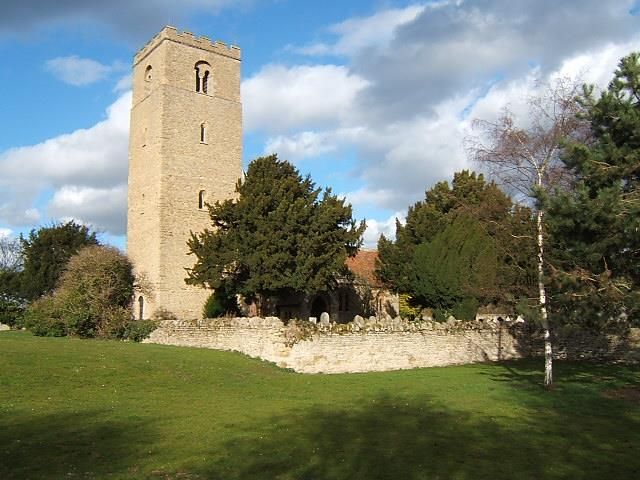
Plan. Small developments have been constructed at the former Swan pub site and behind
Budgens and redundant commercial premises in the High Street have been converted into
residential dwellings.

4.12. To provide the 500 homes required by 2030 much larger developments will be needed
but residents have expressed a strong desire for Clapham to retain its village identity.
Therefore, the layout of new development and maintaining the landscape setting between
Clapham and Bedford and Clapham and neighbouring villages is important. However, the
Neighbourhood Plan cannot extend beyond the boundaries of the parish which precludes our
ability to proscribe development on land outside our borders.

4.13. Clapham has a population of around 4,500 with a rise of around 900 between 2001 and
2011. It is a multi-ethnic parish and there are a high proportion of one-person households
evenly divided between senior citizens and other adults. 78% of dwellings are privately
owned and a Housing Needs Survey carried out in 2016 by Bedfordshire Rural Communities
Charity suggests a need for 2-3 bed houses and bungalows or otherwise suitable properties
(e.g. houses built to Lifetime Homes criteria) if Clapham is to meet the identified current and
future needs of existing owner-occupier residents wishing to stay in the village. The Housing
Needs Survey also showed a need for affordable housing which is unlikely to be met by
normal market provision.

4.14. Economically, Clapham is linked to the nearby towns of Bedford, Milton Keynes and
Rushden for shopping, entertainment and jobs. Many residents commute to work outside the
area but there is also local employment, which the community is keen to retain. Although
residents consider Clapham a desirable place to live, many feel the area needs improvement
and more facilities to maintain a strong and viable local community.

                          Clapham Shopping Parade, High Street

                              © 2018 AECOM Limited. All Rights Reserved.

                                                  8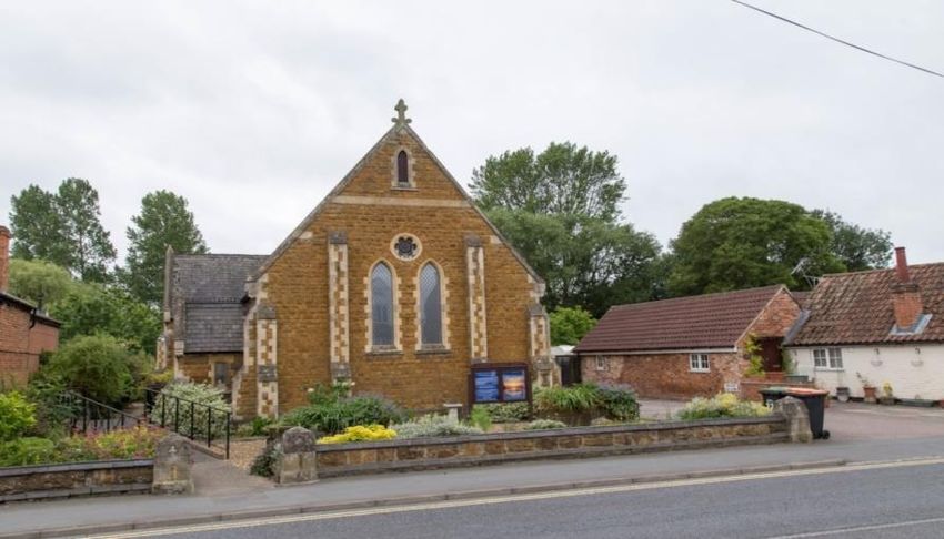
4.15. The village sustains various local shops, a Tesco Express, Budgens and convenience
store, barber, hairdressers, chemist, florist, café, restaurant and three takeaways. There are
also three pubs, two with restaurants, Woodlands Manor hotel, Suzuki garage and a car repair
garage. Bedford & County Golf club is situated on the edge of the village and there are two
churches and a well-used Post Office.

4.16. Facilities include the medical centre, Pre-School, private nursery and Primary School, a
Village Hall complex including Clapham FC football club, a Scout Hut, and Parish Office,
two playing fields providing play equipment and pitches, allotments and two public gardens.
Apart from the play areas on The Glebe estate, green space is concentrated in the centre of
the village and public access to the river is only possible in Riverside Gardens and at The
Ford. Retention of these green spaces and linking them to new green areas to maintain a rural
feel is an important part of the Neighbourhood Plan.

 Playing Field behind the Village Hall Complex

                                              9
5. Sustainable Development
5.1. Sustainable development is a fundamental tenet of the NPPF and, as one of the Basic
Conditions, it is important that Clapham Neighbourhood Plan can contribute towards this. It
can do so by ensuring that its development policies and proposals will meet the needs of
people living and working in the parish. There are three dimensions that constitute
sustainable development in planning terms.
• Economic – contributing to building a strong, responsive and competitive economy
• Social – supporting strong, vibrant and healthy communities
• Environmental – contributing to protecting and enhancing the natural, built and
historic environment
5.2. The NPPF states that Neighbourhood Plans can shape and direct sustainable development
in their area subject to general conformity with strategic policies i.e. national and Bedford BC
planning documents. This Neighbourhood Plan is about ensuring growth provides benefit of
the whole community by
• Providing a wide range of high quality housing to enable residents to remain in the
village and upsize or downsize as needed.
• Ensuring that infrastructure and amenities to support growth are provided, where
appropriate, by developers and through Community Infrastructure Levy funding.
• Maintaining sufficient educational provision for students from age 2 to 11.
• Protecting existing green spaces and providing new green areas.
• Providing routes around the village where it is easy to walk and cycle.
• Protecting and where appropriate, enhancing the significance of heritage assets
including ensuring that new development respects their setting
• Supporting the creation and retention of jobs in the village.
5.3. The Neighbourhood Plan aims to ensure new development provides housing built to
good design principles and with links to existing community facilities such as green spaces
and footpaths. Whilst accommodating the 500 hew homes allocated by Bedford BC the Plan
seeks to balance the effects of growth and maintain the rural setting of the village. New
development will need to be responsive to the village characteristics of Clapham and in
particular, building lines and position within plots, building materials, height, scale, massing,
boundary treatments and attention to architectural detailing. Avoiding substantial areas of
paving for parking that create a car-dominated streetscape and more street trees and trees
within gardens will help to maximise the impact of green space.
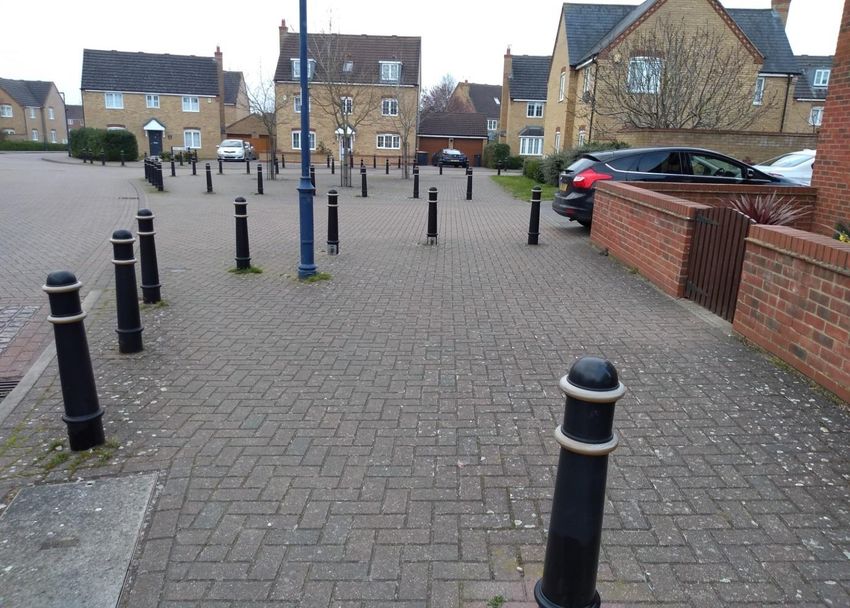
10Poor Quality Public Realm on The Glebe, where Bollards and Paving Dominate the
Street Scene
5.4. Education in the village is currently provided by Clapham Pre-School, a private nursery
and Ursula Taylor School. The allocation of 500 new homes will require a second primary
school to be built and balancing education provision between two schools in one village will
be a challenge. Ursula Taylor Primary School would very much like to be the lead on a new
school. We understand that there would need to be two schools under one management,
working closely and sharing leadership not one school on two sites. Clapham has a thriving
medical centre but parking on the footway at the front of the premises is already a problem at
certain times. There is a car park at the Medical Centre but, dependent on how many new
patients the surgery can support, parking problems may worsen, especially as patients are
drawn from surrounding villages as well as Clapham itself.
5.5. The Village Hall is well used by both clubs & societies and for private functions but the
building is over forty years old and a new building is a priority project for CIL monies from
new development.
5.6. Green spaces within the village and access to the wider countryside are important to
promote a healthy lifestyle and retain the rural setting of Clapham. The Neighbourhood Plan
will seek to protect existing green spaces, link them to new green spaces and maintain the
landscape around Clapham, in particular, the sensitive natural environment between Clapham
and Bedford.
115.7. Surface water drainage is an issue in certain parts of the village and new development
should not increase the load on the existing system such that it would result in an
unacceptable increase in the risk of sewer flooding. A Strategic Environment Assessment
(SEA) and Habitats Regulations Assessment (HRA) have been completed for Clapham.
5.8. Maintaining a large range of services is important for a sustainable community and as
communication is vital, reliable, high speed broadband should be available in new
developments. Whilst there is no business allocation for Clapham in the current Bedford BC
Local Plan 2030, the Neighbourhood Plan seeks to maintain the current business community
and provide opportunities for new business appropriate to a village location. Clapham has a
core of local retail businesses which provide employment and facilities for residents. Such a
range of day to day services and facilities accessible to all is also vital to the sustainability of
Clapham as a village community.
5.9. Residents regularly raise concerns about speeding, the amount of traffic in the village
and parking, particularly along the High Street and especially at peak times. A priority for
the future of the village will be to avoid worsening these problems and taking steps to
improve the current situation. Connecting footpaths and cycle ways will also assist in
reducing the number of vehicle movements.
12Vision and Aims
6. Vision
To provide a thriving, inclusive community in a village which maintains its rural feel
© 2018 AECOM Limited. All Rights Reserved.
7. Aims
7.1 To support more sustainable live-work patterns
7.2 To support sustainable residential development to meet local need
7.3 To promote local economic opportunity and a range of local community and leisure
facilities
7.4 To protect Clapham’s historic, green and rural environments, including the river
and its environs
7.5 To meet the challenges of climate change, through sustainable design and
achievement of net gain in terms of biodiversity
138. Evidence
8.1. The following documents form the evidence base for the policies in line with the
requirements of the Basic Conditions.
Bedford BC Local Plan 2030
Bedford BC Strategic Housing and Employment Land Availability Assessment 2018
Bedford BC Allocations & Designations Plan 2013
Bedford BC Landscape Character Assessment 2014
Bedford BC Adopted Parking Standards for Sustainable Communities SPD 2014
Bedford BC Clapham Parish Profile based on Census 2011
Aecom Site Assessments 2017 & 2018
Aecom Heritage & Character Assessment 2018
Aecom Evidence Base and Policy Review 2018
Aecom Design Codes 2020
Bodsey Ecology Habitats Regulations Assessment 2019
Clapham Neighbourhood Plan Questionnaire 2015
Clapham Youth Questionnaire 2015
Bedfordshire Rural Communities Charity Clapham Housing Needs Survey 2016
Clapham Assessment of Non-designated Heritage Assets 2021
Clapham Play Equipment Survey 2017 & 2019
Clapham Neighbourhood Plan Consultation 2018
14NEIGHBOURHOOD PLAN POLICIES
9. RESIDENTIAL DEVELOPMENT
9.1. Purpose - To support residential development in sustainable locations, to meet local
housing need.
9.2. HG1: Housing Growth
Planning Rationale & Evidence
9.3. Residential development policies have been formulated in line with paragraph 60 of the
NPPF 2021 and policies 3S, 4S, 5S, 7S, 46S, 59S & 77 of the Bedford BC Local Plan 2030.
9.4. In addition, Policy 58S of the Local Plan 2030 requires developments of 10 or more
residential units or 0.5 or more hectares to provide 30% affordable housing. The
Neighbourhood Plan supports the provision of affordable housing and would expect to see
this policy fully applied in Clapham.
9.5. In the residents’ survey there was very clear support to retain the gap between Bedford
and Clapham, concerns about overdevelopment and the loss of the village feel. In an open
question on fears for the village, 33% expressed concerns about overdevelopment, 28% in
regard to losing the green gap between Clapham and Bedford, and 20% about losing the
village feel of Clapham. Many of these considerations overlapped and were connected,
although other concerns relating to overdevelopment included environmental, infrastructure
and traffic considerations.
9.6. One in five of the households in the village who responded to the 2015 survey said they
had, or would soon have, a problem finding suitable living accommodation. This was
predominantly homes for sale, although there was substantial demand for homes for rent. In
addition, there was a significant requirement for specialist housing – 19% of those looking
for accommodation in the village.
9.7. The resident survey revealed most support for 1-2 bedroom starter homes and 2-3
bedroom family houses and bungalows, as shown in the table below:
Type of home % of respondents rating as top
three priority
1-2 bedroom small starter homes/homes for older people 25%
2-3 bedroom small family homes 24%
Bungalows for older people 20%
4+ bedroom large family homes 12%
Specialist homes e.g. sheltered housing 12%
Homes with office or workshop space 6%
Apartments 3%
159.8. The independent housing needs survey has also identified a requirement for specific
provision of homes for rent and shared ownership. The Housing Needs Survey identified a
need for 13 homes with a proposed mix of:
For rent: 2 x 1-2 bedroom bungalows, 2 x 2 bedroom flats or houses, 2 x 2 bedroom
houses, 2 x 3 bedroom houses
For shared ownership: 4 x 2 bedroom houses, 1 x 3 bedroom house
9.9. The resident survey also identified 76 households expressing a need for suitable
affordable accommodation either currently or in the near future. There was also substantial
support (76%) from residents for affordable homes to meet the needs of people with a
connection to the village.
9.10. Our survey of residents showed that 80% of respondents supported housing which
enables older people to live in suitable accommodation, and 78% supported smaller homes to
enable young people to remain in the parish.
9.11. The most recent population projections for Bedford Borough, the ONS 2016-based
Subnational Population Projections for 2016-2030, estimate that the Borough’s population
will increase by approximately 14.5% during this period but the 65+ population is projected
to rise by 40% and the 85+ population by 52%. Across both the housing needs survey and
the residents’ survey, there was significant evidence of demand for homes suitable for older
residents and those with specialist needs. New homes to enable older people to move into
more suitable accommodation were supported by 80% of those who responded to the
residents’ survey, the most well supported type of homes in the survey. 9.12. In terms of the
types of homes requested, specialist homes were felt by 12% of respondents as one of the top
three priorities, with 58% supporting bungalows specifically.
HG1: Housing Growth
HG1. i. Residential development will be supported in sustainable locations. These are:
• Within the Settlement Policy Area (settlement boundary) defined in the
Local Plan.
• The site allocated in Policy HG2;
• Redevelopment of suitable brownfield sites and/or refurbishment of
existing buildings, where there is sufficient supporting infrastructure and
no conflict with surrounding land uses;
• Infill development for gaps in existing built frontages, where the
requirements of Policy ED3 are capable of being met.
16ii. Residential schemes must demonstrate high standards of design and
landscaping, meeting the requirements of Policies ED1, ED3 and other policies.
iii. Particular support will be given to schemes for smaller dwellings (1, 2, 3
bedrooms) and/or housing suitable for older people. 2.
Interpretation
9.12. Policy HG1 will enable housing growth in sustainable locations by supporting growth
within or adjacent to the existing Settlement Policy Area and the local amenities and
infrastructure within it. Redevelopment of brownfield or existing sites would need to ensure
that residential properties would not suffer a detrimental impact from surrounding site uses.
For example, sites or buildings near to commercial uses that generate noise or smell would
not be supported.
9.13. Other policies in the Local Plan and this neighbourhood plan set out restraints to
development, for example by protecting the landscape setting to settlements.
9.14. The Neighbourhood Plan has a broader strategic ambition to create a village for all
ages. Policy HG1 provides particular support for those seeking a first home or small family
home and the older population. The parish profile, based on the 2011 census, observes that
the number of people aged 85 and over in Clapham is less than the Bedford average and the
absence of specialist residential or nursing care might be a reason. A care home would not
contribute to the 500 dwellings allocated to the village but comments on the residents’ survey
supported the construction of this kind of accommodation in the village.
9.15. HG2: Housing Site Allocation
Planning Rationale & Evidence
Site selection
9.16. Clapham is required to allocate 500 homes and a one form entry primary school on a
serviced two form of entry/two hectare site in the Bedford Borough Local Plan 2030.
9.17. Site allocations were considered by the Parish Council at their meeting on 18th
December 2018 and the decision taken that site 806 (Milton Hill) should be allocated for
development of 500 homes and provision of land for a two form of entry/two hectare site in
the Neighbourhood Plan. The Parish Council decision was based on a balanced assessment
of the sites, evidenced from technical work by Aecom on the sites put forward in Bedford
BC’s Call for Sites, the SEA carried out by Aecom and the ability of sites to meet planning
policy and Neighbourhood Plan aims. The allocation also recognises the impact on residents
adjoining the sites and the wider impact on the whole village.
179.18. By 2017, Milton Hill - site 806 and East Clapham - site 75 had emerged as the sites able
to deliver 500 homes plus the land for a new school. There is no capacity to expand the
existing school site to accommodate another form of entry for each year. The smaller sites or
combinations of small sites could not demonstrate that they could provide the two hectares of
land required for a new school and/or were not located close to other sites so that they could
cumulatively achieve the 500 home requirement.
9.19. Milton Hill and East Clapham were assessed against criteria; in particular the impact on
traffic, the impact on historic structures and non-designated heritage assets, protection of the
rural landscape and environmental contribution.
9.20. Traffic and congestion in the village is an ongoing concern for residents. The allocation
of Milton Hill will encourage traffic to enter and leave the village on the A6 via Highfield
Road rather than driving through the village to access the A6 via Clapham Road. Traffic
from East Clapham would enter/exit from the High Street or The Slade/Highbury Grove and
access the A6 via Clapham Road. Queues regularly form from the A6 Aldi roundabout along
Clapham Road and into Clapham as evidenced by the photographs below and on page 38.
Queues also form at the Highbury Grove/High Street junction as parked cars reduce
Highbury Grove to a single track road, shown in the photograph on page 7.
A second school will encourage residents in the north of the village to walk to school,
reducing the amount of traffic driving through the village to a single school. Whilst the
construction of 500 homes will create significant negative effects on transportation on all
sites, the SEA notes that “minor positive effects may be achieved through the delivery of a
new primary school alongside housing at Land at Milton Road, which may help reduce traffic
flows through the village at peak times.”
Traffic queuing along Clapham Road and past the village entrance into Bedford Road.
9.21. Except for Twinwood Hospital, the listed buildings and twenty one non-designated
heritage assets identified in the Plan are all located in the south eastern part of the village. St.
18Thomas a Beckett Church (Grade I listed) is adjacent to the southern boundary of the East
Clapham site and the proposed access through Ursula Taylor School is likely to impact on the
stone wall to the High Street, one of the non-designated heritage assets. Milton Hill is not in
the vicinity of any designated heritage assets, and the SEA therefore considered that the
likelihood of significant effects on them is very low (the nearest Listed Buildings are beyond
the A6 strategic transport corridor). The SEA concluded that “where the potential for
significant negative effects exist, this is apparent across all the potential growth options, with
Option 1 (Milton Hill) performing marginally better by a reduced potential for negative
effects of significance in relation to the historic environment.”
9.22. There is the potential for archaeology to be present on both sites and the Neighbourhood
Plan Group will seek to work closely with Historic England to ensure avoidance or suitable
mitigation of impacts to any archaeological remains discovered. The need for archaeological
investigation to be undertaken prior to any development commencing is reflected in the
Borough Local Plan 2030 and the Neighbourhood Plan polices.
9.23. A development of 500 homes anywhere in the village will have an impact on the
landscape through the loss of greenfield land at the settlement edge and impact on land, soil
and water resources. Both sites are in flood zone 1 and contain no Tree Preservation Orders.
Land lies higher at north end of the Milton Hill site, up to 70m AOD, whereas land at East
Clapham is within the 45m AOD contour which contains the village as a whole. However,
the Milton Hill site contains some previously developed land, which East Clapham does not
and a green buffer to the west and a contiguous natural area to the north will mitigate the
visual impact of the housing. The buffer will also maintain the separation between Clapham
and the neighbouring village of Oakley.
9.24. Aecom considered that both sites were of medium landscape quality, value and
sensitivity and the SEA concluded that whilst the Neighbourhood Plan would have residual
minor long-term negative effects, no significant negative effects are considered likely overall
on the rural setting of the village or impact upon neighbouring villages.
9.25. The selection of Milton Hill is supported by the community as evidenced in the series of
consultations with residents. This mainly related to traffic concerns, particularly the use of
Highbury Grove and Green Lane. Local opinion was also slightly in favour of a two school
option, and existing residents in the northern part of the village were particularly supportive
as they would be able to more easily walk to school with their children.
9.26. The Aecom SEA identified uncertain effects on climate change and the potential for
significant negative effects on air quality for both site options.
9.27. East Clapham performed better on health & wellbeing because of the potential air and
noise pollution impacts associated with development adjacent to the A6 as well as possible
higher levels of isolation of the Milton Hill community in development. However, East West
Rail announced in 2020 that their preferred route will run to the east of the East Clapham site
19and, therefore, the site will likely be impacted by noise and pollution from diesel freight
trains. The Milton Hill site is also closer to the village Medical Centre and the local
secondary school in Oakley and the provision of a large, contiguous green space to the north
and west, which links into existing green space on The Glebe development, sustainable
transport routes and measures to take traffic away from the village centre will all impact
positively on residents’ health & wellbeing.
9.28. East Clapham also performed better for biodiversity as Milton Hill is constrained by the
nearby County Wildlife Sites at Judges Spinney and Browns Wood. However, through a
Design Code for the site, the opportunity exists to link these wildlife sites with a natural area
to the north.
9.29. Both sites have clear and co-ordinated ownership and are being promoted by significant
site promoters. Both site promoters have indicated that 500 homes could be delivered at
around 100 units per annum. In their submissions to Bedford BC East Clapham stated that
they would expect to complete building within 4 - 5 years, Milton Hill within 6 – 10 years.
The criteria analysis therefore concluded that both sites are capable of delivery within the
plan period but delivery would be subject to market conditions. Milton Hill promoters have
subsequently confirmed that they anticipate a build out rate of 40-50 dwellings per year per
outlet and that they would expect two outlets to be on the site at any one time. They have
also conducted a number of capacity studies that demonstrate that 500 dwellings can be
provided on the site whilst also meeting all other policy requirements including open space
and land for the primary school by adopting established urban design and place making
principles.
9.30. Concerns were raised initially about the capacity for the northern site to accommodate
500 homes and land for a school but the site was reconfigured and Aecom concluded that the
revised site has the capacity to accommodate 500 dwellings, the 2ha of land required for a
school and green space (Site Assessment Addendum 2018, page 25, paragraph 4.2). East
Clapham is a slightly larger site at 33ha compared to 30.88ha for Milton Hill but lower
density housing would result in loss of more agricultural land and likely more expensive
housing. The Bedfordshire Rural Communities Charity’s Housing Needs Survey indicated
that 1, 2 and 3 bedroom houses were needed in the village.
9.31. On the basis of the technical reports and the analysis of criteria, the Parish Council
considered that Milton Hill (site 806) best fulfilled the objectives of the Neighbourhood Plan.
The subsequent SEA, carried out in 2020 concluded that “where the potential for significant
negative effects exist, this is apparent across all the potential growth options, with Option 1
(Milton Hill) performing marginally better by a reduced potential for negative effects of
significance in relation to the historic environment” and that “the preferred option in 2020
remains Option 1.” The Parish Council will continue to support this site through the planning
process.
20Archaeological investigation
9.32. The allocated site is not in the vicinity of any designated heritage assets, and the SEA
considered that the likelihood of significant effects on them is very low (the Listed Buildings
are all in the south east of the village). However, effects cannot be ruled out in terms of non-
designated assets.
The Historic Environment Record (HER) for Bedford reveals that Clapham has a rich
archaeological history, including potential prehistoric features/remains and sites/finds from
the Iron Age and Romano-British period. It is therefore considered that there is the potential
for archaeology to be present on the allocated site and undesignated heritage assets could
receive notable harm from development due to insensitive design, layout or massing.
9.33. Site allocation Policy HG2 vii. recognises the potential sensitivity of the site in terms of
non-designated assets and identifies a site specific requirement to conform with Bedford
Local Plan Policy in this respect, by ensuring archaeological investigations are carried out to
inform any proposal. However, there is also the potential for future development to provide
beneficial enhancement of heritage assets or their settings within the Plan area, particularly
through public realm and access improvements and these are considered in section three of
the Plan.
9.34. The review concluded that where the potential for significant negative effects exists,
this is the case across all the potential growth options, with Option 1 performing marginally
better through a reduced potential for significant negative effects in relation to the historic
environment. The outcomes of the SEA have therefore been addressed by the policies of the
Neighbourhood Plan and the preferred option therefore remains Option 1.
9.35. The Parish Council will support this site at the planning application stage provided that
the development proposals conform to the policies in the Bedford BC Local Plan 2030 and
the Clapham Neighbourhood Plan.
Design
9.36. Good design is integral to Neighbourhood Plans to support sustainability and help make
development acceptable to communities. Research, such as for the Government’s
Commission for Architecture and the Built Environment (now part of the Design Council),
has shown that good design of buildings and places can improve health and well-being;
increase civic pride and cultural activity; reduce crime and anti-social behaviour and reduce
pollution. Aecom was therefore commissioned to provide a master plan and design codes for
the allocated site in line with NPPF 2021 125 - 127 and based on the character and local
qualities of Clapham. The key elements of the Design Code are included in policy HG2 and
developers will be required to include these so that new development does not place strain on
the existing village and its resources and is designed and delivered as a functioning part of
Clapham.
21Landscape and Green infrastructure
9.37. There are no internationally or nationally designated sites of biodiversity importance in
Clapham. However, Judges Spinney is a County Wildlife Site situated on the Oakley side of
the boundary between Clapham and Oakley parishes. The Spinney abuts onto the allocated
development site and policy HG2 viii. therefore seeks to protect the setting of this important
site.
9.38. Policy AD28 of the Bedford BC Allocations & Designations Plan sets out the
requirement for play space in new developments. Policy HG2 seeks to ensure that new play
areas are equipped to a high standard with a range of facilities suitable for a group of
children/young people and to avoid very small play areas with little equipment which are
unattractive to children/young people. The Neighbourhood Plan Group carried out surveys
with families at both Pre-School and Ursula Taylor Primary to establish the equipment
preferred in new play areas and the results are available on the website – www.clapham-
pc.gov.uk
New School
9.39. Clapham has a primary school - Ursula Taylor School, which is situated at the southern
end of the High Street. At key drop-off and pick-up times the High Street outside is
congested with parked cars and children walking along and across the busy road. There is
therefore a conflict between vehicles and pedestrians which holds up traffic and gives rise to
concerns about safety. Policy HG2 viii seeks to avoid such conflict by providing a secure
drop off point within the school site. The policy could also encourage students to walk or
cycle to school as traffic will not present a threat at the school gate.
HG2: Housing Site Allocation
HG2. i. The site indicated on map 2 is allocated for residential development of 500
dwellings and a serviced two hectare site for a primary school.
ii. Whilst residential development will be the predominant use for the site,
encouragement is given to mixed use elements, including employment, live/work
units and community facilities, whilst meeting the requirements of Policy EC1.
iii. The mix of types of residential accommodation should focus in particular on
meeting the local need for smaller dwellings (1, 2, 3 bedrooms).
iv. Support will also be given to housing suitable for older people and schemes
including or comprising extra care facilities.
v. Development schemes must demonstrate high standards of design, responding
to the site topography, and meeting the requirements of Policies ED3. This
includes creation of a rural horizon towards the top of the site, rather than a
building skyline.
22vi. There should be an emphasis on pedestrian connectivity and permeability,
meeting the requirements of policies ED3, IT2 and other policies. This includes
convenient pedestrian connections to the new school.
vii. Landscape design and green infrastructure must include:
• An open landscape buffer between built development and the Judges
Spinney ancient woodland;
• Play facilities concentrated in one central location, rather than smaller
play areas in different parts of the site;
• An attractive green environment for pedestrian movement and
recreation, including high quality green spaces and street trees;
• Existing hedges retained where possible and re-planting secured if their
removal is unavoidable.
viii. Development proposals for the site should achieve biodiversity net gain,
meeting the requirements of Policy ED1.
ix. The design and layout of the school must include access, circulation and drop-
off facilities to minimise on-street parking and allow dropping off within the
school site.
Interpretation
9.40. Policy HG2 allocates a sustainable site adjacent to the current Settlement Policy Area
for housing and sets key principles for the development of that site. The policy applies in
conjunction with the other policies in this Neighbourhood Plan
9.41. The site is the only one of the three considered for allocation that contains some
brownfield land.
9.42. Archaeological investigation should be undertaken prior to any development
commencing as required by Bedford BC Local Plan 2030.
9.43. The site is likely to be developed by different house builders and the design principles
in the policy will enable the creation of an integrated site. Compliance with the policy
requirements is likely to require a masterplan, especially if planning applications for different
parts of the site are submitted incrementally. This is especially important to ensure that there
is a coherent and planned approach to providing green infrastructure and good pedestrian
links, as required in other policies in this plan.
9.44. Employment or community uses are enabled as part of a mix, rather than being a
requirement. Such uses could be incorporated into ground floor units within housing blocks,
23so would not necessarily reduce site capacity. Use of Lifetime Homes principles is
encouraged, to ensure that housing is flexible to changing needs.
Map 2 - Allocated Site – 806 Milton Hill
10. EMPLOYMENT AND COMMUNITY
10.1. Purpose - To support more sustainable live-work patterns, with local economic
opportunity and a range of local community and leisure facilities.
10.2. EC1: Employment
Planning Rationale & Evidence
10.3. Employment policies have been formulated in line with paragraph 81, 83 and 84 of the
NPPF 2021 and policies 75, 69S, 77S, 81 and 82 of the Bedford BC Local Plan 2030.
10.4. Clapham has a thriving business community which provides both employment and the
local facilities which make the village a popular place to live. There are approximately 50
businesses in the village excluding the Twinwood Business Park and many small businesses
run by individuals.
2410.5. Local shops, including a post office, are very important to the community and are all
situated in the High Street. The shopping parade comprises takeaways, a chemist, hairdresser
& beauty salon, barber, florist, motor parts retailer and a café and there are 3 convenience
stores, 4 pubs and/or restaurants and 2 garages.
10.6. Woodland Manor Hotel and the Bedford & County Golf Club are situated in Green
Lane at the southern end of the village and the Ursula Taylor Primary School and Clapham
Pre-School also provide employment for local residents. Of the 3,612 residents between the
ages of 16 and 74, approximately 71% are economically active. Of these 9% are self-
employed and 4% work from home.
10.7. Respondents to the questionnaires considered agriculture/food production, service
trades and pubs/cafes/restaurants as the most important businesses in the village. They had
no strong views on the type of new businesses needed in the village in future and only 4%
were looking to start a business in the next few years. Half of the young people who
responded to the questionnaire considered that new business was needed in Clapham,
particularly another café.
EC1: Employment
EC1. New employment, workspace or community facilities will be supported, where
there is sufficient supporting infrastructure and no conflict with surrounding
land uses. Such support is subject to there being no significant adverse impacts
on:
• The amenities of any nearby residential properties;
• The rural and built character of the area.
Interpretation
10.8. B2 & B8 use class facilities are available on the neighbouring Twinwood Business Park
and such facilities are not therefore needed in Clapham village. Traffic congestion in the
village is a particular problem so traffic generation from B2 & B8 business, particularly
Heavy Goods Vehicles, would harm the amenity of residents and the built environment.
10.9. New E use class business/retail premises of a scale and nature to complement existing
facilities in the village would help to maintain Clapham as a sustainable village and policy
EC1 will ensure that new business development respects the rural village setting of Clapham
and will not adversely affect existing residential properties. The impact of traffic movement,
noise, disturbance, dust, smell, vibration and visual intrusion could harm neighbouring
properties and the natural and built environments.
10.10. Support for schemes depends on the requirements of other policies in this plan being
met.
2510.11. EC2 & EC3: Community Facilities
Planning Rationale & Evidence
10.12. Community Centre policies have been formulated in line with paragraphs 93 of the
NPPF 2021 and policy 98 of the Bedford BC Local Plan 2030.
10.13. In the residents’ survey there was very clear support to retain a Community Centre on
the site of the existing Village Hall, with 84% of respondents in favour. 49% of those
responding to the youth questionnaire also agreed that the new Community Centre should be
on the Playing Field & 34% had no opinion. Those disagreeing were mostly concerned about
loss of Playing Field space but the Charity Commission would require an equivalent piece of
land to be allocated as playing field in the event that a new centre was built.
10.14. A wide range of sport & leisure facilities were requested by young people in response
to the survey with a swimming pool and gym by far the most popular. 25% of adult residents
also want more sports facilities, particularly a sports complex (gym, multi-use courts for
tennis, badminton, basketball etc.). A swimming pool would not be economically feasible
given that there are three private and one public pool within a three mile radius of the village
but indoor sports facilities could be included in a new Community Centre.
10.15. In the 2011 census only 46.9% of the village considered their health to be very good
and 16% described their day to day activities as limited due to illness or disability and
improved facilities at the Community Centre could help to improve the overall health of the
village.
EC2. Community Facilities
EC2. i. Existing community facilities must remain in community use, unless:
• A similar or better facility is provided in close proximity;
• It can be demonstrated that the community use is no longer viable.
Clapham Village Hall
26EC2. ii. Community facilities of particular importance include:
• The Village Hall and Football Club, High Street;
• Changing Rooms at King George V Playing Field, High Street;
• Scout Hut, King George V Playing Field, High Street;
• Clapham Pre-School, King George V Playing Field, High Street;
• Ursula Taylor School, High Street.
Interpretation
10.16. Harm to amenity could include traffic movement and disturbance, noise, pollution,
fumes, visual or other impacts.
10.17. Support for schemes depends on the requirements of other policies in this plan being
met.
EC3: Community Centre Site Allocation
Planning Rationale & Evidence
10.18. The Clapham community centre is over 40 years old and is becoming expensive to
maintain. It is an important community hub but the current building does not incorporate
indoor sporting facilities (other than an attached clubhouse for Clapham FC) and a wider
range of facilities would promote healthy living in the village.
EC3: Community Centre Site Allocation
EC3. i. The site indicated on map 4 is allocated for a new community centre.
ii. Development of the site should include car and cycle parking meeting the
requirements of Policy IT2. These should be provided either within the site itself
or on the site of the Village Hall if this is scheduled for demolition as part of the
scheme.
iii. Other development in or around the site must not compromise the
accessibility of the site and or its potential for development of the community
centre.
27Interpretation
10.19. Policy EC2 enables the development of a community centre, near to the existing
Village Hall. It is envisaged that the site of the Village Hall (to be demolished) will be used
for parking, servicing and amenity space to serve the new facility. This being the case, the
site for any planning application would be likely to include both the allocated site and the
land occupied by the existing Village Hall.
10.20. The addition of 500 homes to the village will also increase demand for community
facilities and policy EC3 will ensure that facilities identified as of particular importance to
residents are retained or improved. Retention and improvement of community facilities will
attract new residents and make Clapham a more sustainable settlement.
Map 3 – Location of Community Centre
2811. ENVIRONMENT AND DESIGN
11.1. Purpose - To protect Clapham’s historic, green and rural environments and to
meet the challenges of climate change.
11.2. ED1: Rural Character and Landscape Settings
Planning Rationale & Evidence
11.3. Rural Character and Landscape policy has been formulated in line with paragraphs 131,
174 & 179 of the NPPF 2021 and policies 35S, 37 - 39, 40, 42S & 51S of Bedford BC Local
Plan 2030. It also takes account of the Bedford BC Landscape Character Assessment and the
Clapham Heritage & Character Assessment commissioned by the Neighbourhood Plan
Group.
11.4. Clapham is situated immediately to the north of Bedford Town and its rural identity is
at risk from growth on the northern fringe of the town. The land between Clapham and
Bedford is an important landscape area as it contains a County Wildlife site and identifies
Clapham as a rural village.
2911.5. Twinwood Business Park was submitted as a site for a new settlement in the 2015 and
2020 Borough Call for Sites and although not included in the Local Plan 2030 has not been
excluded as a potential future new settlement by Bedford BC. The new settlement would
extend into Clapham Parish and erode the open landscape to the north east of the village and
the setting of Twinwood, a designated Ancient Woodland and the culturally significant Glenn
Miller Museum.
11.6. The Borough Landscape Character Assessment states that the overall landscape strategy
for the Renhold Clay Farmland, which includes the northern and eastern, largely undeveloped
parts of Clapham parish, is to “conserve and enhance the open rural landscape.”
Development guideline 3B.1.23 for the Great Ouse Limestone Valleys, which incorporates
the western developed part of the parish and Bromham and Oakley is “to improve settlement
edges to maintain separation between settlements.”
11.7. Aecom’s Clapham Heritage & Character Assessment states that the “open rural setting
surrounding the village and rural gap between Bedford and Clapham” is one of the “positive
aspects of character which should be sustained, reinforced or enhanced.” The report
concludes that “development within the rural landscape, beyond the limits of existing
settlement to the east and on the rural approach into the village should be limited to maintain
the separate identity of Clapham from the larger settlement of Bedford.”
11.8. Aecom also noted that the “landscape of scattered ancient woodlands and a mixed land-
use of arable farmland on the higher ground” was a key characteristic of the village and
panoramic and sweeping views from high points in the landscape particularly along The
Baulk, Twinwood footpath and Twinwood Road are particularly sensitive to change. They
concluded that new development should “maintain openness of hillside farmland and protect
panoramic views.”
11.9. In 2015 Clapham Neighbourhood Plan Group circulated a questionnaire to all
households in the village and a separate youth questionnaire. 84% of respondents to the main
questionnaire were concerned or very concerned about the impact of new development on the
entrances and exits to the village and 30% of residents’ fears for the future were that Clapham
would be joined to Bedford. 27% of respondents to the youth questionnaire commented on
the importance of the quiet, rural feel of the village. 11.20. Towers Leisure Club was
constructed in 2017 in the gap between Bedford and Clapham and further development would
threaten Clapham’s identity as a village. The open landscape between Clapham and Bedford
is important to preserve as it contains the Clapham Park Wood County Wildlife Site which,
as an ancient woodland of high biodiversity value, is particularly sensitive to change. In
addition, the six listed buildings in the village and most of the Tree Preservation Orders,
which inform the history of the village and sense of place, are located on the Bedford side of
the village.
3011.10 Since 2011 national planning policy has recognised the importance of protecting and
enhancing ecological networks and producing a net gain in biodiversity. Increasing
biodiversity is also important to residents with 66% of respondents to the 2015 questionnaire
requesting planting of trees/orchards & recreating wildflower meadows.
One of the remaining, mature trees at the corner of Green Lane and High Street
© 2018 AECOM Limited. All Rights Reserved
11.11 Sustainable green infrastructure is also important in tackling climate change and the
Government’s 25 Year Environment Plan seeks to provide ecosystems and landscapes more
resilient to climate change. Wildlife sites are generally too small and too isolated, leading to
declines in many of England’s characteristic species and with climate change, the situation is
likely to get worse. Clapham has lost many of its mature trees over recent years and there are
no internationally or nationally designated sites of biodiversity importance. There are
however three County Wildlife Sites – Clapham Park Wood, Twinwood and Oakley Little
Wood plus the River Great Ouse and a roadside nature reserve. In addition, Browns Wood
and Judges Spinney, also County Wildlife Sites, are situated on the Oakley side of the
boundary between the two parishes.
11.12 Bedfordshire and Luton Biodiversity Recording and Monitoring Centre which gathers
verified species records from recognised wildlife sites and the public has identified various
rare and protected species such as wood white butterflies and fieldfares in the County
Wildlife Sites in Clapham. Policy ED1 therefore seeks to enhance as well as protect these
sites and the green corridors between them.
ED1: Rural Character and Landscape Settings
ED1. i. Development must avoid significantly encroaching into or harming the open
and rural landscape settings of Clapham’s built settlements.
ii. Trees and hedgerows should be retained and incorporated into the design and
layout of development. Where loss of trees is unavoidable, schemes should
include replacement trees of native species and similar level of amenity.
31You can also read