CNN-BASED PLACE RECOGNITION TECHNIQUE FOR LIDAR SLAM - The ...
←
→
Page content transcription
If your browser does not render page correctly, please read the page content below
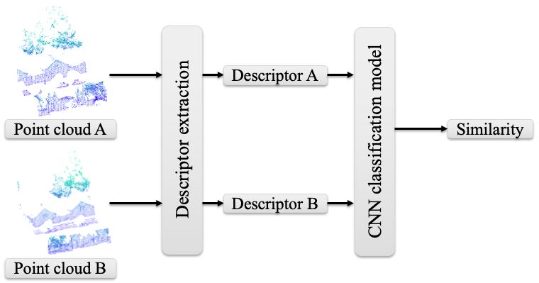
The International Archives of the Photogrammetry, Remote Sensing and Spatial Information Sciences, Volume XLIV-M-2-2020, 2020
 ASPRS 2020 Annual Conference Virtual Technical Program, 22–26 June 2020

 CNN-BASED PLACE RECOGNITION TECHNIQUE FOR LIDAR SLAM

 Y. Yang *, S. Song, C. Toth

 Dept. of Civil, Environmental and Geodetic Engineering, The Ohio State University, 470 Hitchcock Hall, 2070 Neil Avenue
 Columbus, OH 43210, USA - (yang.2695, song.1634, toth.2)@osu.edu

KEY WORDS: Lidar, Global descriptor, Deep learning, Place recognition

ABSTRACT:

Place recognition or loop closure is a technique to recognize landmarks and/or scenes visited by a mobile sensing platform previously
in an area. The technique is a key function for robustly practicing Simultaneous Localization and Mapping (SLAM) in any environment,
including the global positioning system (GPS) denied environment by enabling to perform the global optimization to compensate the
drift of dead-reckoning navigation systems. Place recognition in 3D point clouds is a challenging task which is traditionally handled
with the aid of other sensors, such as camera and GPS. Unfortunately, visual place recognition techniques may be impacted by changes
in illumination and texture, and GPS may perform poorly in urban areas. To mitigate this problem, state-of-art Convolutional Neural
Networks (CNNs)-based 3D descriptors may be directly applied to 3D point clouds. In this work, we investigated the performance of
different classification strategies utilizing a cutting-edge CNN-based 3D global descriptor (PointNetVLAD) for place recognition task
on the Oxford RobotCar dataset1.

 1. INTRODUCTION 2018) (Yin H et al., 2018) (Yin H et al., 2019) (Yin P et al., 2018a)
 (Yin P et al., 2018b). The major limitation for extracting semantic
One important aspect of SLAM algorithms is that the localization features is the assumption that there are enough static objects
errors keep accumulating as the number of measurements keeps which have been adequately learned by the pretrained CNN
increasing, due to the errors in measurements caused by the noise model. However, this assumption may not always be satisfied in
of sensors (Dhiman et al., 2015). To handle this problem, SLAM real-world practice. On the other hand, with the global descriptor,
algorithms rely on place recognition (PR), or loop closure the PR task is handled as a similarity modeling problem in which
detection (LCD) techniques, wherein the algorithms are able to Nearest Neighbor (NN) method is commonly used for
recognize previously visited places and then use them as classification. Additionally, one interesting task in the real-world
additional constraints for increasing the precision of localization PR practice is classification under the restriction that we may
estimation and solving the global localization problem. Therefore, only observe a single example of each possible scenario before
a robust PR scheme could enhance the robustness and making a prediction about a test instance. This problem is known
performance of SLAM algorithms. For the Lidar-SLAM, PR is as one-shot learning (Koch et al., 2015), and the Siamese neural
still a challenging task and very few of the state-of the art networks have been demonstrated as an effective solution for
algorithms has solved the loop closure problem (Singandhupe et one-shot learning in imagery application (Yin W et al., 2015) and
al., 2019). Many methods have been proposed for this task, and low dimensional 3D semantic segment descriptors classification
a traditional solution is sensor integration with other sensors, (Cramariuc et al., 2018).
such as camera (Olson, Edwin, 2009a) (Wu et al., 2016) or GPS
(Emter, Thomas, 2012) (Emter et al., 2018). However, these To efficiently generate reliable PR candidates by improving the
techniques face challenges, such as vision based methods performance of classification network, in this study we
suffering from illumination changes, season-to-season based investigated a one-shot learning classification method, the CNN-
appearance changes and viewpoints differences, and poor GPS based Siamese network with high dimensional global descriptors
performance in urban areas. on 3D Lidar data (Figure 1). In the experiment, we compared the
 effectiveness of classification between our CNN-based classifier,
Since Lidar data is invariant to lighting and appearance changes, a commonly used nearest neighbor (NN) method and random
the geometric methods for PR with 3D Lidar data, such as line forests (RF) which is a typical nonlinear classic machine learning
feature-based scan matching, key point matching and 3D local classifier. The details of proposed method are discussed in the
feature-based strategies are widely investigated (Olson, Edwin, remainder of this paper, structured as follows. Section 2 reviews
2009b) (Bosse et al., 2013) (Dubé et al., 2017). Unfortunately, the proposed method, including network for global feature
extracting and matching these features could be difficult in descriptor extraction and CNN classifier model. The experiments,
certain environments. To that end, CNN-based solutions have including training, testing and performance comparison are
recently been proposed as effective learning tools to generate presented in Section 3. Finally, the conclusions are summarized
features from general environments. Due to the different ways to in Section 4.
learn and extract descriptors, these solutions can be classified in
two categories: semantic (local) level feature-based (Dubé et al.,
2018) and frame (global) level feature-based (Angelina, Hee Lee,

* Corresponding author
1
 https://robotcar-dataset.robots.ox.ac.uk/

 This contribution has been peer-reviewed.
 https://doi.org/10.5194/isprs-archives-XLIV-M-2-2020-117-2020 | © Authors 2020. CC BY 4.0 License. 117
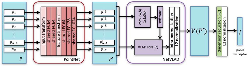
The International Archives of the Photogrammetry, Remote Sensing and Spatial Information Sciences, Volume XLIV-M-2-2020, 2020
 ASPRS 2020 Annual Conference Virtual Technical Program, 22–26 June 2020

 2. METHOD volumetric representations (Qi et al., 2016) (Yin P et al., 2018a).
 The downside of these networks is that they cannot handle well
2.1 Global Descriptor the large-scale outdoor PR problems. Additionally, for these
 networks, Lidar data need to be preprocessed to provide proper
Compared to its image counterpart, applying a CNN model to 3D input which is computationally expensive. To directly operate on
points is more challenging due to the fact points in a point cloud an unordered points subset in a point cloud, (Angelina, Hee Lee,
are generally unordered. Some works handled this challenge by 2018) proposed the PointNetVLAD 2 network which integrates
projecting 3D point clouds into 2D image plane (Su et al., 2015) PointNet network and VLAD layer (Figure 2).
(Yin P et al., 2018b) or transforming point clouds into 3D

 Figure 1. Proposed network for PR task

 Figure 2. Network architecture of PointNetVLAD (Angelina, Hee Lee, 2018)

The PointNet extracts local feature descriptors for each input where , = margin
point by encoding points into vectors in a higher dimensional = Euclidean distances between global descriptor
space. In the next phase, the NetVLAD layer aggregates local vectors
features into the VLAD bag-of-words (BoWs) global feature
descriptor vectors. Additionally, since NetVLAD is a symmetric In this work, pretrained PointNetVLAD baseline network was
function and PointNet model transforms each point in the point used as global feature extractor.
cloud independently, the output global descriptor is invariant to
the order of the points. In the training process, PointNetVLAD 2.2 CNN-based Classifier
was trained with the lazy quadruplet loss in which the Euclidean
distances between descriptors are used for calculating similarity. As depicted in Fig 1, two input point clouds are firstly given to
During inference (testing), NN method was used for two branches of the Siamese network which are distinct
classification. The lazy quadruplet loss is defined as: PointNetVLAD networks and create global descriptors. In the
 next stage, these two descriptors are combined and processed by
 = max &' + "#$ − %&'! , - a CNN classification model in which the similarity score is
 ! ( calculated as the final output. The structure of CNN classification
 + max &/ + "#$ − %&'"∗ 1 - (1) model is detailed in Figure 3.
 ) (

2
 https://github.com/mikacuy/pointnetvlad.git

 This contribution has been peer-reviewed.
 https://doi.org/10.5194/isprs-archives-XLIV-M-2-2020-117-2020 | © Authors 2020. CC BY 4.0 License. 118
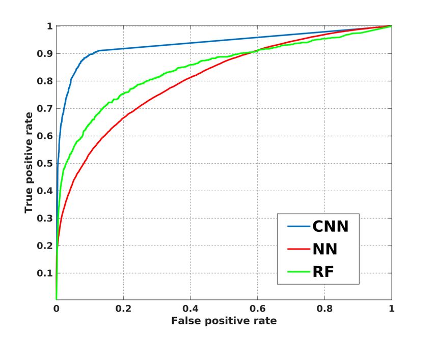
The International Archives of the Photogrammetry, Remote Sensing and Spatial Information Sciences, Volume XLIV-M-2-2020, 2020
 ASPRS 2020 Annual Conference Virtual Technical Program, 22–26 June 2020

 Figure 3. Network architecture of CNN classification model
One advantage of Siamese network is that the feature extraction 3.2 Comparing Different Classification methods
model and classification model can be trained and used
simultaneously or independently. In this work, we trained and In this section we compare the performance of different
used CNN classification model independently for a fair classification methods, e.g. CNN-based classifier, NN and RF by
comparison of classification performance with respect to other using the same set of global feature descriptors extracted from
classifiers. The binary cross entropy loss with stochastic gradient testing datasets. In terms of training the RF, the input is two
descent (SDG) is applied during training process. The loss concatenated descriptors and output is their matching probability.
function is formed as: The closest neighbour in NN method is decided based on the
 Euclidian distance in descriptor vector space. The receiver
 operating characteristic (ROC) curves of the different classifiers
 = − log − (1 − ) log(1 − ) (1) are shown in Figure 5. The best accuracy is achieved by the CNN-
 based classifier. The numerical results are presented in Table 1.
where = logic label CNN-based classifier outperforms NN and RF in both general
 = output of CNN classification model accuracy and true positive (recall) rate which are 95.3% and 70.1%
 respectively. Note that the commonly used NN method performs
 3. EXPERIMENT the worst, achieving a general accuracy of 61.1%, and true
 positive rate of 40.7%. The classic nonlinear classifier RF, used
3.1 Training the Model as a reference, outperforms NN with 88.5% in general accuracy
 and 57.6% in true positive.
Since we only investigate the performance of classifiers in this
work, the same training and test dataset, as used in original
PointNetVLAD research, was applied to guarantee a consistent
performance of feature extraction. The dataset was built from the
Oxford RobotCar dataset (Maddern et al., 2017) in which 44 sets
of full and partial runs were used. Training and testing reference
maps are geospatially separated from each run with a proportion
of 70% and 30%, respectively. Then submaps were segmented
from reference maps following the rules: (1) each submap
contains all Lidar points within a 20m trajectory of the vehicle,
and (2) the intervals between submaps are 10m and 20m for
training and testing datasets, respectively. Finally, 21,711
training submaps and 3,030 testing submaps were segmented out
from original dataset. The submaps within 10m intervals in
centroid coordinates are seen as structurally similar and labelled
as “positive” and those with 50m are dissimilar and “negative”.

The training results for the CNN classification model are shown
in Figure 4. The loss quickly converged during the first few
epochs and remains almost constant in subsequent epochs. Thus, Figure 5. ROC curves for different classifiers with same set of
we stopped training at 1000 epochs. The CNN classification
 global feature descriptors
model was trained on a Nvidia GeForce Titan Xp GPU.

 Method General Accuracy True Positive Rate
 NN 61.1% 40.7%
 RF 88.5% 57.6%
 CNN-based 95.3% 70.1%
 classifier
 Table 1. Matching Accuracy statistics of different classifiers

 Examples visualizing the matching results are presented in Figure
 6 in which (a)~(c) are true positive matching, (d)~(f) are false
 positive matching. It can be seen that the proposed method shows
 robustness to noise, such as objects changing (Fig 6(a)),
 Figure 4. Training results of CNN classification model

 This contribution has been peer-reviewed.
 https://doi.org/10.5194/isprs-archives-XLIV-M-2-2020-117-2020 | © Authors 2020. CC BY 4.0 License. 119
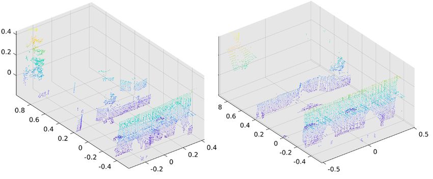
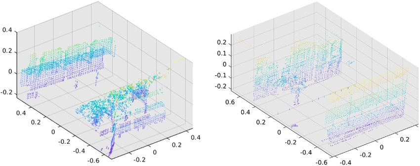
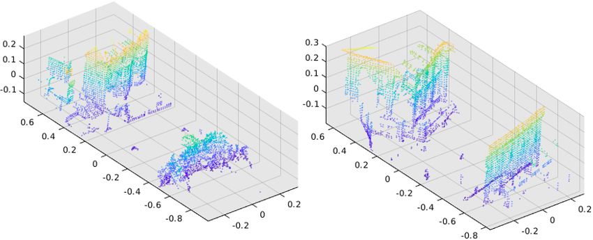
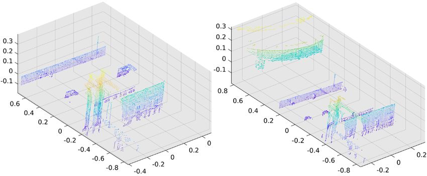
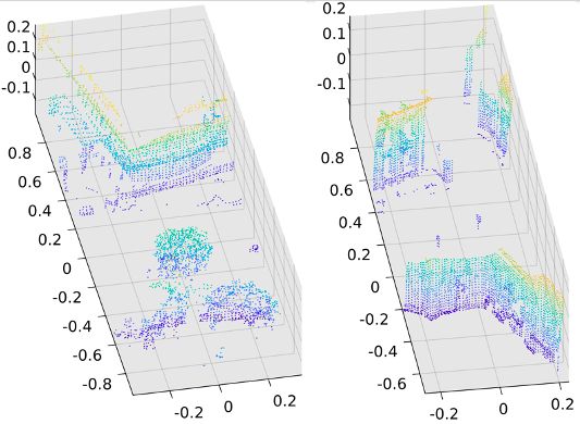
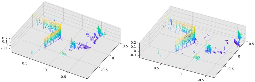
The International Archives of the Photogrammetry, Remote Sensing and Spatial Information Sciences, Volume XLIV-M-2-2020, 2020
 ASPRS 2020 Annual Conference Virtual Technical Program, 22–26 June 2020

viewpoint changing (Fig 6(b)) and both objects and viewpoint and achieves true positive rate at 70.05%. However, many false
changing (Fig 6(c)). On the other hand, Fig 6(d)~(f) reveal the matchings occur when scenarios contain very similar features. In
fact that the CNN based classifier fails to distinguish dissimilar the future work, we will try to (1) increase the performance in
submap pairs when two scenarios contain very similar features, recall by using geometric or other constrains to reject false
such as semblable building structures and trees. matches, and (2) integrate the proposed place recognition method
 into Lidar SLAM.
 4. CONCLUSION

In this work, we investigated the performance of CNN based
classifier with Lidar data for PR task. The testing results show
that the proposed model outperforms both NN and RF methods

 (a)

 (b)

 (c)

 This contribution has been peer-reviewed.
 https://doi.org/10.5194/isprs-archives-XLIV-M-2-2020-117-2020 | © Authors 2020. CC BY 4.0 License. 120
The International Archives of the Photogrammetry, Remote Sensing and Spatial Information Sciences, Volume XLIV-M-2-2020, 2020
 ASPRS 2020 Annual Conference Virtual Technical Program, 22–26 June 2020

 (d)

 (e)

 (f)
 Figure 6. Examples of matching results, (a)~(c) are true positive matching, (d)~(f) are false positive matching.

 This contribution has been peer-reviewed.
 https://doi.org/10.5194/isprs-archives-XLIV-M-2-2020-117-2020 | © Authors 2020. CC BY 4.0 License. 121
The International Archives of the Photogrammetry, Remote Sensing and Spatial Information Sciences, Volume XLIV-M-2-2020, 2020
 ASPRS 2020 Annual Conference Virtual Technical Program, 22–26 June 2020

 REFERENCES Singandhupe, A. & La, H. 2019, "A review of slam techniques
 and security in autonomous driving", 2019 Third IEEE
Angelina Uy, M. & Hee Lee, G. 2018, "Pointnetvlad: Deep International Conference on Robotic Computing (IRC)IEEE,
point cloud based retrieval for large-scale place recognition", pp. 602.
Proceedings of the IEEE Conference on Computer Vision and
Pattern Recognition, pp. 4470. Su, H., Maji, S., Kalogerakis, E. & Learned-Miller, E. 2015,
 "Multi-view convolutional neural networks for 3d shape
Bosse, M. & Zlot, R. 2013, "Place recognition using keypoint recognition", Proceedings of the IEEE international conference
voting in large 3D lidar datasets", 2013 IEEE International on computer vision, pp. 945.
Conference on Robotics and Automation IEEE, pp. 2677.
 Wu, Q., Sun, K., Zhang, W., Huang, C. & Wu, X. 2016, "Visual
Cramariuc, A., Dubé, R., Sommer, H., Siegwart, R. & and LiDAR-based for the mobile 3D mapping", 2016 IEEE
Gilitschenski, I. 2018, "Learning 3d segment descriptors for International Conference on Robotics and Biomimetics
place recognition", arXiv preprint arXiv:1804.09270. (ROBIO)IEEE, pp. 1522.

Dhiman, N.K., Deodhare, D. & Khemani, D. 2015, "Where am Yin, H., Tang, L., Ding, X., Wang, Y. & Xiong, R. 2018,
I? Creating spatial awareness in unmanned ground robots using "LocNet: Global localization in 3D point clouds for mobile
SLAM: A survey", Sadhana, vol. 40, no. 5, pp. 1385-1433. vehicles", 2018 IEEE Intelligent Vehicles Symposium (IV)IEEE,
 pp. 728.
Dubé, R., Cramariuc, A., Dugas, D., Nieto, J., Siegwart, R. &
Cadena, C. 2018, "SegMap: 3d segment mapping using data- Yin, H., Wang, Y., Ding, X., Tang, L., Huang, S. & Xiong, R.
driven descriptors", arXiv preprint arXiv:1804.09557. 2019, "3d lidar-based global localization using siamese neural
 network", IEEE Transactions on Intelligent Transportation
Dubé, R., Dugas, D., Stumm, E., Nieto, J., Siegwart, R. & Systems, vol. 21, no. 4, pp. 1380-1392.
Cadena, C. 2017, "Segmatch: Segment based place recognition
in 3d point clouds", 2017 IEEE International Conference on Yin, P., He, Y., Xu, L., Peng, Y., Han, J. & Xu, W. 2018a,
Robotics and Automation (ICRA) IEEE, pp. 5266. "Synchronous adversarial feature learning for lidar based loop
 closure detection", 2018 Annual American Control Conference
Emter, T. 2012, "Integrated Multi-Sensor Fusion and SLAM for (ACC)IEEE, pp. 234.
Mobile Robots", Proceedings of the 2011 Joint Workshop of
Fraunhofer IOSB and Institute for Anthropomatics, Vision and Yin, P., Xu, L., Liu, Z., Li, L., Salman, H., He, Y., Xu, W.,
Fusion LaboratoryKIT Scientific Publishing, pp. 91. Wang, H. & Choset, H. 2018b, "Stabilize an unsupervised
 feature learning for LiDAR-based place recognition", 2018
Emter, T. & Petereit, J. 2018, "Stochastic cloning and IEEE/RSJ International Conference on Intelligent Robots and
smoothing for fusion of multiple relative and absolute Systems (IROS)IEEE, , pp. 1162.
measurements for localization and mapping", 2018 15th
International Conference on Control, Automation, Robotics and Yin, W. & Schütze, H. 2015, "Convolutional neural network for
Vision (ICARCV)IEEE, pp. 1508. paraphrase identification", Proceedings of the 2015 Conference
 of the North American Chapter of the Association for
Koch, G., Zemel, R. & Salakhutdinov, R. 2015, "Siamese neural Computational Linguistics: Human Language Technologies,
networks for one-shot image recognition", ICML deep learning pp.901.
workshop, Anonymous Lille.

Maddern, W., Pascoe, G., Linegar, C., Newman, P., 2017. 1
year, 1000 km: The Oxford RobotCar dataset. The International
Journal of Robotics Research 36 (1), 3-15.

Olson, E. 2009a, "Recognizing places using spectrally clustered
local matches", Robotics and Autonomous Systems, vol. 57, no.
12, pp. 1157-1172.

Olson, E.B. 2009b, "Real-time correlative scan matching", 2009
IEEE International Conference on Robotics and
AutomationIEEE, pp. 4387.

Pedregosa, F., Varoquaux, G., Gramfort, A., Michel, V.,
Thirion, B., Grisel, O., Blondel, M., Prettenhofer, P., Weiss, R.
& Dubourg, V. 2011, "Scikit-learn: Machine learning in
Python", the Journal of machine Learning research, vol. 12, pp.
2825-2830.

Qi, C.R., Su, H., Nießner, M., Dai, A., Yan, M. & Guibas, L.J.
2016, "Volumetric and multi-view cnns for object classification
on 3d data", Proceedings of the IEEE conference on computer
vision and pattern recognition, pp. 5648.

 This contribution has been peer-reviewed.
 https://doi.org/10.5194/isprs-archives-XLIV-M-2-2020-117-2020 | © Authors 2020. CC BY 4.0 License. 122

You can also read