Coastal management risk analysis of an embayed beach in Majorca island
←
→
Page content transcription
If your browser does not render page correctly, please read the page content below
Research Article

Coastal management risk analysis of an embayed beach in Majorca
island
Tiago Abreu1,2       · Benjamín Parreño‑Mas3 · José Pinto‑Faria1

Received: 28 April 2020 / Accepted: 12 August 2020
© Springer Nature Switzerland AG 2020

Abstract
Coastal erosion affects many coastlines around the world. This is a serious problem for the Balearic Islands, located at
the western Mediterranean Sea, since the economy of the region largely relies on tourist activities along the sandy
coastline. Therefore, coastal management strategies are required, particularly, in anthropized coasts as it is the case of
Cala Millor beach (north-eastern Mallorca). A risk analysis for this micro-tidal sandy beach is performed in this paper. It is
recognized that the beach suffers a persistent loss of sediments since its natural balance was changed due to anthropic
activities that took place in that Spanish coast in the 1960s. Some solutions can be adopted to solve this problem, but
it is important to be aware that, close to the shore, the seabed is covered by a native vegetation known as Posidonia
Oceanica. This seagrass meadow plays an important role in this coastal system, being responsible by the lamination
of the waves through energy dissipation, which are inextricably linked to coastal morphology. Therefore, any solution
needs to address local specificities, and its consequent potential impact must be incorporated into the coastal risk man-
agement process. This study analyzes the failure modes identified according to the failure modes and effects analysis/
failure mode, effects and criticality analysis, proposing a set of recommendations, in order to mitigate the occurrence of
failure modes and to minimize risks.

Keywords Coastal management · Environmental impacts · Morphodynamics · Risk analysis · Urban beach

1 Introduction                                                           many Mediterranean regions, whose economies, largely
                                                                         rely on tourist activities along the sandy coastline [3].
Coastal erosion is one of the main problems of coastlines                   In this paper, an anthropized micro-tidal sandy beach
around the world. Many parameters can be associated to                   located in Mallorca (Balearic Islands, western Mediterra-
coastline retreat (e.g., maritime climate, sediment trans-               nean Sea) is analyzed. Cala Millor beach (north-eastern
port, sea level rise, etc.), but it is unclear to what extent            Mallorca) is a typical “sun and sand” tourist destination in
these factors influence coastal erosion [1, 2]. Particularly,            urban environments of the Mediterranean region, char-
in densely populated coastal regions with high urban                     acterized by an elevated seasonal turnover. However, the
development, besides important environmental impacts,                    beach suffers a persistent loss of sediments since its natu-
there is an increasing socio-economic concern related                    ral balance was changed due to anthropic activities that
to erosive processes because they affect population,                     took place in that Spanish coast in the 1960s, leading to
nearshore infrastructures and assets. This is the case for               the disruption of the natural mechanisms of protection
                                                                         against high-energy events.

* Tiago Abreu, taa@isep.ipp.pt | 1Civil Engineering Department, School of Engineering (ISEP), Polytechnic of Porto, Porto,
Portugal. 2CESAM‑Centre for Environmental and Marine Studies, University of Aveiro, Aveiro, Portugal. 3Universidad Politecnica de Valencia,
Valencia, Spain.

        SN Applied Sciences      (2020) 2:1535        | https://doi.org/10.1007/s42452-020-03325-6

                                                                                                                           Vol.:(0123456789)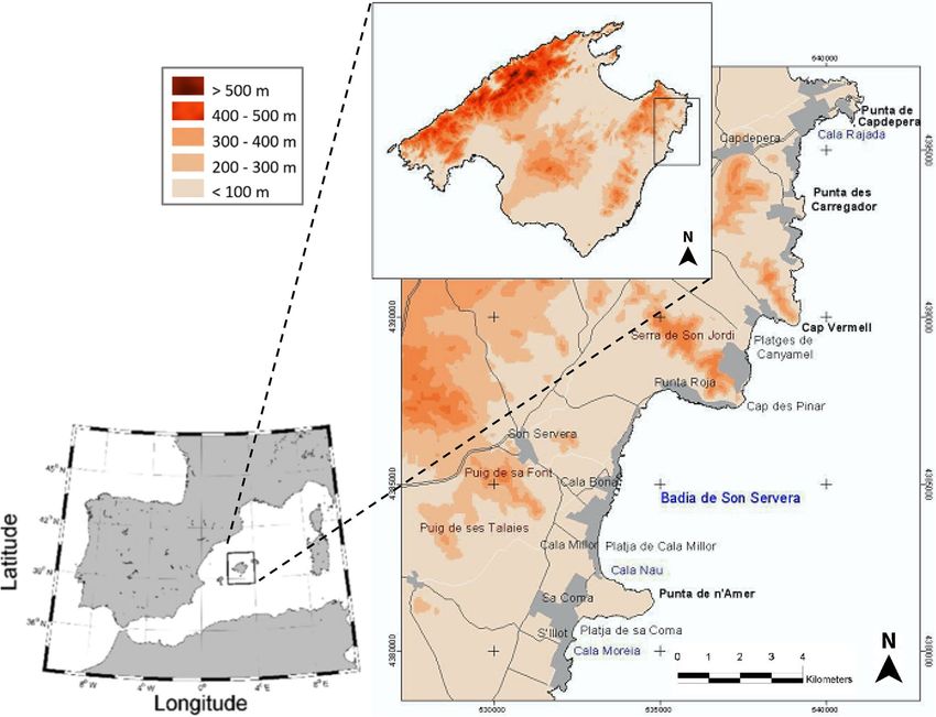
Research Article               SN Applied Sciences       (2020) 2:1535         | https://doi.org/10.1007/s42452-020-03325-6

   According to Tintoré et al. [4], in 1956, the area of the     Section 3 focuses on the risk management process. Sec-
emerged beach was of 44,260 m2. This comprises the origi-        tion 4 describes different solutions for short- and long-
nal natural scenario when the beach, the lagoon and the          term coastal management, identifying and analyzing its
field dunes in the southern part of the beach were not           risks. Finally, the conclusions are drawn in Sect. 5.
disturbed by anthropic modifications. In 1968, due to the
urbanization works and tourism development, the beach
surface increased significantly (+ 25 568 m2) because the
                                                                 2 Study site
urban development affected the dune field and sand was
removed and brought to the beach. The destruction of the
                                                                 2.1 Cala Millor beach
original system and the absence of appropriate manage-
ment led to a continuous retreat associated with the sand
                                                                 Cala Millor beach is situated on the north-eastern coast of
redistribution and beach equilibrium adjustment [5].
                                                                 the Spanish Mallorca island in the western Mediterranean
   New monitoring technologies were required for Cala
                                                                 Sea, near the eastern coast of the Iberian Peninsula (Fig. 1).
Millor and by 2007 the IMEDEA (Mediterranean Institute
                                                                 It belongs to the municipalities of Sant Llorenç and Son
for Advanced Studies) developed a coastal video monitor-
                                                                 Servera, located at about 60 km from the capital of Mal-
ing system that operated temporally [6]. Since 2011, the
                                                                 lorca, Palma de Mallorca.
beach monitoring program of the Balearic Islands Coastal
                                                                     Offering a fine and clean sand, Cala Millor beach is also
Observing and Forecasting System (SOCIB) covers Cala Mil-
                                                                 called “Arenal de Son Servera” and it is located in the south
lor beach. This program includes topobathymetric surveys,
                                                                 bay area of Son Servera. The economy of Son Servera was
video monitoring and in situ measurements of nearshore
                                                                 primarily based on a rich agriculture, livestock and fish-
waves and currents, among others [7, 8].
                                                                 ing. Nevertheless, in the past decades, a strong economic
   The observations confirm that the natural equilibrium
                                                                 expansion, in which has been immersed Cala Millor, asso-
beach state was modified, making the beach more reflec-
                                                                 ciated the beach to a popular summer tourist area. The
tive and vulnerable than before. Morphodynamic mode-
                                                                 beach and its municipalities offer many opportunities for
ling of the beach seems to support an observed problem
                                                                 leisure and entertainment and, nowadays, tourist activities
resulting from an imbalance of sediment transport due
                                                                 are the actual main source of income.
to the drift from north to south during storm situations,
                                                                     Cala Millor is a micro-tidal sandy beach located in a
which can significantly affect the future use of the beach
                                                                 large natural bay, where the beach is embedded in 1600 m
[9]. It is necessary to correct the problem, or at least miti-
                                                                 length and 35 m wide, being orientated NNE-SSW. The
gate it, by means of sustainable and economic solutions.
                                                                 coastal area is characterized by low ground bounded by
Some solutions can be adopted to solve this problem,
                                                                 cliffs. As shown in Fig. 1, the bay of Son Servera is bounded
but it is important to be aware that, close to the shore,
                                                                 on the north by the “Cape des Pinar” and south of “Punta
the seabed is covered by a native vegetation known as
                                                                 de n’ Amer.” Although beneath the cliffs there are steep
Posidonia Oceanica [10]. Indeed, the Balearic Islands are
                                                                 slopes, the bathymetry in the central part of the bay is
located at the transition area Atlantic/Mediterranean and
                                                                 different, following the same topography pattern with
possess its own biodiversity in the world’s oceans. This
                                                                 regular and shallow slopes covered by Posidonia Oce-
Posidonia meadow has an important role in the system
                                                                 anica (Fig. 2). The dry beach contains a small layer of fine
[11]. This kind of vegetation is responsible for the lamina-
                                                                 sand, which rests on a rocky stratum which is frequently
tion of the waves through energy dissipation inextricably
                                                                 exposed after large storms. The sand essentially consists
linked to coastal morphology [12, 13]. Thus, any solution
                                                                 of bioclastic sand. The coarse fraction does not exist and
needs to address local specificities, and its consequent
                                                                 the average of the particle size is uniform, with a median
potential impact must be incorporated into coastal risk
                                                                 grain size d50 = 0.33 ± 0.3 mm [14].
management.
   In this study, a risk analysis is performed for Cala Mil-
lor beach in order to assess its current situation. Different    2.2 Wave climate
solutions are discussed, envisaging a sustainable coastal
management and meeting the local societal needs where            The offshore wave conditions at Cala Millor beach are
preservation of the environment is essential to assure both      recorded by the Capdepera buoy. This buoy is part of
residents’ welfare and the competitiveness of the tourist        Puertos del Estado (the Spanish holding of harbors) buoys
sector.                                                          network and it is located 36.45 km northeast of Cala Millor
   The paper is organized as follows. Section 2 is devoted       at 48 m depth (3.49° E, 39.65° N). Providing hourly hydro-
to the description of the study site, providing informa-         dynamic data, the buoy has been operative during the
tion of the beach, wave climate and local specificities.         period 1989–2014.

Vol:.(1234567890)
SN Applied Sciences          (2020) 2:1535             | https://doi.org/10.1007/s42452-020-03325-6                 Research Article

Fig. 1  Location of Son Servera’s bay in Mallorca island in the western Mediterranean basin

   Over the past decade, the buoy mainly registered                      periods are up to 7 s and an average of 8.7 s, averaging
waves coming from the first and second quadrants,                        6.2 s.
where swells from the first quadrant possess a higher fre-                  Considering the Capdepera buoy data, Abreu et al.
quency and present an average direction of 18° (N18E).                   [9] studied the morphodynamics of the beach, consider-
The second quadrant presents lower frequencies with an                   ing representative wave regimes for Calla Millor beach.
average direction of approximately 117° (S63E).                          The simulations were performed with the SMC program
   Figure 3 shows the annual/seasonal variability in                     (System of Coastal Modeling), which integrates a series
terms of significant wave height (Hs) and wave peak                      of numerical models and allows to model the study site.
period (Tp) over the past three decades. This buoy data                  The results enabled a better understanding of Cala Millor
analysis allows the characterization of the wave cli-                    beach morphology, taking into consideration the wave cli-
mate, revealing the usual variability associated with the                mate and, also, the roughness effects caused by Posidonia
Mediterranean climate (defined by hot, dry summers                       Oceanica meadow. The analysis revealed a clear imbalance
and rainy winters). The figure presents the average val-                 of the sediment transport for different wave directions,
ues as well as their fluctuations regarding the standard                 reflecting the differences between the waves originated in
deviation around the average. During summer months                       the first or second quadrants. This difference enhanced the
(June–August), the wave height and the peak period                       sediment transport to the south. This imbalance between
are smaller in comparison to colder months (Decem-                       north and south may be responsible for an annual net loss
ber–February). The maximum wave height values are                        of sediments in the bay, resulting in the disappearance of
about 1.2 m, while the average is 1.0 m. The longer peak                 the sand substrates of the southern dry beach area.

                                                                                                                     Vol.:(0123456789)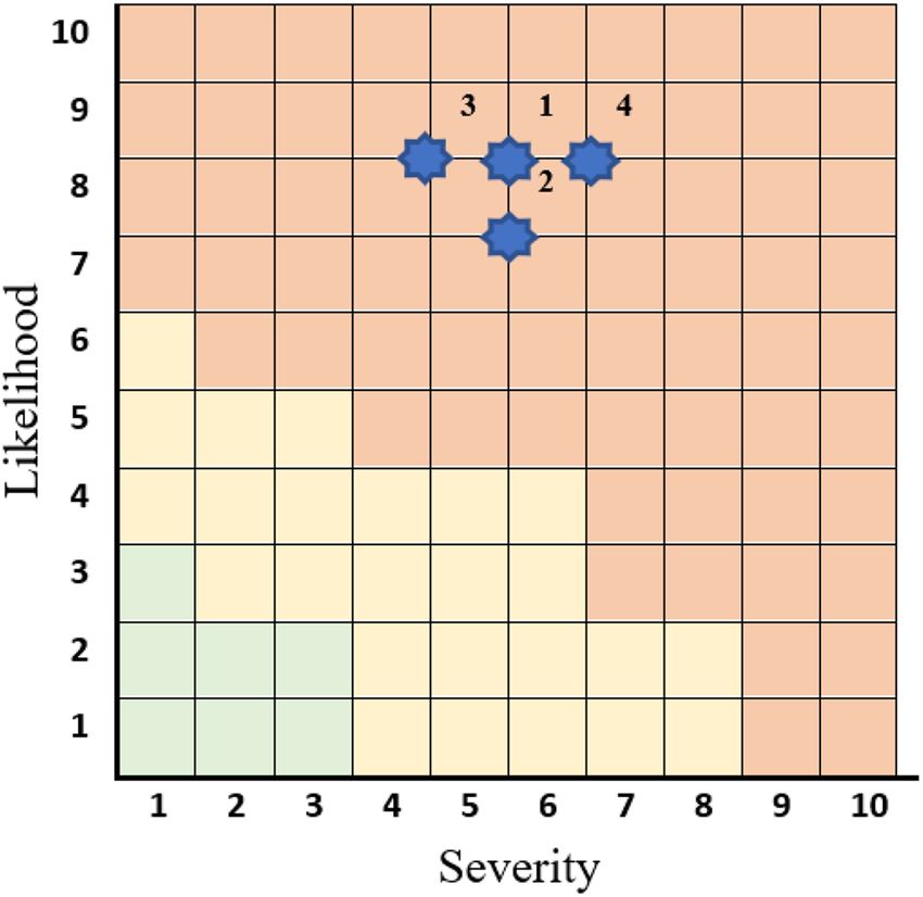
Research Article SN Applied Sciences (2020) 2:1535 | https://doi.org/10.1007/s42452-020-03325-6
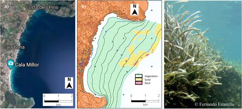
Fig. 2 a Aerial view of Son Servera’s bay; b morphology (sand, rock, sea bottom flora) and their bathymetrical location; c native vegeta-
tion—Posidonia Oceanica
3 Risk management process
According to the ISO 31000:2018 [14], all activities involve
risk, and these risks are managed through their identifica-
tion and analysis. With the implementation of a risk assess-
ment, the need to impose some type of treatment to sat-
isfy their risk criteria is defined. Risk management of this
coastal stretch needs to consider the external and internal
contexts, setting a strategy and achieving objectives and
making informed decisions.
Figure 4 highlights how the risk management process
involves the systematic application of policies, procedures
Fig. 3 Capdepera buoy: Hs and Tp over the past three decades. The and practices to the activities of communicating and con-
solid lines represent average values. The dotted lines add and sub- sulting, establishing the context and assessing, treating,
tract the standard deviation
monitoring, reviewing, recording and reporting risks.
The risk assessment process is interpreted as the overall
risk identification, analysis, and assessment process. This
Abreu et al.’s [9] simulations also addressed the rough- process should be implemented in a systematic, iterative
ness effects associated with the Posidonia Oceanica and collaborative way, based on the knowledge and points
meadow covering part of the seabed. The seagrass is of view of the stakeholders.
extended from 5 to 30 m depth, reaching in some areas The identification of the risk is based on a process of
up to 35 m. The results support the idea that the mor- research, recognition and description of risks, which can
phological changes can be significantly attenuated in contribute to achieve, or prevent, its objectives. It involves
the presence of Posidonia Oceanica because the veg- identifying the risk sources, events, respective causes and
etation induces a reduction of the wave height. This potential consequences, which may involve the use of
expected natural energy dissipation [11] is relevant for historical data, theoretical analysis, well-informed and
coastal management, since the influence of the vegeta- expert opinions, and also takes into account the needs of
tion directly affects coastal morphology. Therefore, any the stakeholders.
intervention on that coastal system needs to take into Risk analysis is the process to understand the nature
account the existence of this vegetation. and determine the level of risks. It provides the basis
Vol:.(1234567890)
SN Applied Sciences         (2020) 2:1535         | https://doi.org/10.1007/s42452-020-03325-6                  Research Article

Fig. 4  Process risk man-
agement (based on ISO
31000:2018 [15])

for risk assessment and risk treatment decisions. It also         operating states, failure modes and sequence of effects,
includes risk estimation. The risk analysis can be influenced     allowing a reasoned reflection on the means of detecting
by divergences, or biases, opinions, perceptions, and judg-       and preventing failure modes and mitigating their effects
ments of risks. Events with a high degree of uncertainty          [18].
can bring additional difficulty in their quantification, which       The present study intends to name and analyze the fail-
can be a problem in the analysis of events with severe con-       ure modes identified in this case study, to collect as much
sequences, and it may be necessary to combine different           information as possible about causes, effects, degrees of
techniques.                                                       qualification of severity, occurrence, and detection, for the
    Risk analysis provides input to risk evaluation, for deci-    failure modes, according to the FMEA/FMECA and to pre-
sion-making on whether the risk should be treated and             sent and propose a set of recommendations, in order to
for the definition of the most appropriate strategy and           mitigate the occurrence of failure modes and to minimize
methods for dealing with risks. Depending on the circum-          risks.
stances of the analysis, the risk can be qualitative, semi-          The most frequently used method is the Risk Priority
quantitative or quantitative, or a combination of these.          Number (RPN):
    The failure modes and effects analysis (FMEA) and
                                                                  RPN = S × L × D                                               (1)
its semi-quantitative extension, based on the criticality
analysis called Failure Mode, Effects and Criticality Analy-      where S represents the severity, L is the likelihood and D is
sis (FMECA), are a methodology that is applicable to any          the detection. Normally, the severity of the failure mode is
organization and process, allowing to view risk manage-           assessed on an ordinal scale from 1 (no effect) to 10 (dan-
ment as a global process. A FMEA/FMECA is an inductive            gerous effect). The likelihood is associated to the prob-
risk analysis process, designed to identify possible failure      ability of occurrence and is classified from 1 to 10, where
problems before they occur, assessing the associated legal        1 means a remote probability of occurrence and 10 and
effects associated with these failure modes, and identify-        a very high probability of occurrence. The possibility of
ing and applying measures to mitigate their consequences          detecting the potential first level of failure rates from 1 to
[16].                                                             10, where 1 means that detection is likely (certain) and 10
    According to Ben-Daya et al. [17], in the application of      means that detection is impossible.
the FMEA, a series of questions should be asked: “What are           With the potential failures listed, we can classify the
the failures that can arise?,”“How likely are these failures to   failures according to the Severity, Likelihood and Detec-
occur?,” “How severe are they, in the case of occurrence?”        tion indexes in order to calculate the risk. Respectively, the
and yet, if not the most important, “How can these failures       Severity (or severity of the failure and its effect) and Likeli-
be avoided?.”                                                     hood (occurrence) values can be obtained from Tables 1
    The advantages that the use of this process can bring to      and 2.
its users are based on the systematization and methodical            In addition, to calculate the risk, it is necessary to obtain
character of analysis of the various subsystems, respective       the detection level for the failures and their effects. Note

                                                                                                                  Vol.:(0123456789)
Research Article SN Applied Sciences (2020) 2:1535 | https://doi.org/10.1007/s42452-020-03325-6
Table 1 FMEA/FMECA— Index Criterion
severity index
1 Undetectable effect on the system
2 Low severity causing mild annoyance in the stakeholder
3
4 Moderate severity: dissatisfied stakeholder with noticeable loss of performance
5
6
7 High severity with high stakeholder dissatisfaction
8
9 Very high severity: potential security risk and serious problems on the beach
10
Table 2 FMEA/FMECA—likelihood index All the characteristics of the indicators are maintained, and
Index Criterion
an analysis is created for each failure mode, according to
the template shown in Table 4.
1 Remote possibility of occurrence Each table, by failure mode, will have a comment sec-
2 Very low frequency: 1 time every 10 years tion resulting from the knowledge obtained from other
3 Uncommon: 1 time every 5 years case studies, or from researchers and specialists in this
4 Low frequency: 1 time every 2 years area, contributing to the assessment of the failure mode
5 Occasional attendance: once a year that the Risk Analysis Team needs to develop.
6 Moderate attendance: 1 time per semester
7 Frequent: 3 times per semester
8 High frequency: once a month 4 Calla Millor coastal management
9 Very high frequency: once a week
10 Maximum frequency: 1 time per day 4.1 The use of FMEA/FMECA
In the absence of any action to protect the beach, since
Table 3 FMEA/FMECA—detection index part of the natural beach recovery was destroyed with the
Index Criterion
construction of the seafront, nature will continue its natu-
ral rhythm, leaving natural processes to erode the beach.
1 Almost certain failure mode detection The problem of the recreational use of the beach in the
2 south area will be aggravated. The loss of sand, even if
3 Very high probability of failure mode detection temporary, will affect the quality of the beach, decreasing
4 the number of users or moving them to other parts of the
5 High probability of failure mode detection beach affecting the capacity of the beach. Ultimately, the
6 incomes associated with the local tourism will diminish.
7 Low probability of detecting failure mode Therefore, in the long-term, if any concrete action is taken,
8 this leads to an untenable situation at the economic and
9 Remote probability of failure mode detection social levels.
10 Considering the implementation of technical solutions,
two different perspectives can be considered regarding
sand management in a beach with these characteristics. A
that detection is a value that shows the efficiency of the short-term intervention would allow the use of the beach
fault detection controls (failure mode). Table 3 lists the during touristic periods, whereas a long-term intervention
criteria associated to it, evidencing the higher the value aims to correct the instability of the coastline.
assigned to the detection index, the greater the difficulty Nevertheless, any solution needs to take into account
in detecting the failure. the existence of the Posidonia Oceanica meadow. This is
FMEA is not a specific requirement of ISO 31000:2018, a natural protection in the Balearic marine ecosystem,
but it does satisfy the criteria by providing a process for contributing to the protection of the coast. It stabilizes
managing risk. Here, a different form is presented than the the submerged beach and tends to form reefs, reducing
one normally seen in the state of the art of FMEA/FMECA. the energy of the swell that reaches the active zone of the
Vol:.(1234567890)SN Applied Sciences (2020) 2:1535 | https://doi.org/10.1007/s42452-020-03325-6 Research Article
Table 4 FMEA/FMECA—adapted table for the risk matrix [16]
beach profile. Therefore, they act like natural submerged The process of analyzing the identified risks, which basi-
detached breakwaters. For this reason, its protection cally consist of the sand loss and the destruction of the
should be mandatory in zones where it exists, as it is the native vegetation, seeks to understand the nature of the
case of the Cala Millor beach. risk. Tables 5, 6, 7 and 8 make use of the FMEA/FMECA risk
Therefore, any actions that could suppose an aggression analysis process. The recommended actions presented in
to Posidonia Oceanica must be avoided (e.g., discharges each table are summarized in both short- and long-term
to the sea that could produce biochemical changes or coastal management perspectives and these solutions
induce changes in the water quality, affecting the pho- are presented and discussed in more detail the following
tosynthesis of this vegetation). In addition, the persistent sections.
erosive coastal processes that could take off the plants in The calculation of RPN in the traditional FMEA/FMECA
its upper limits during big storms and the free anchoring formulation can induce decision-making strongly influ-
of boats with anchors that can hurt the plants need to be enced by the Detection index, so the analysis should focus
considered. on the first two indices, Severity and Likelihood, according
For Cala Millor beach, the Ministry of Agriculture, Fish, to the new approach.
Food and Environment (MAGRAMA), advised by IMEDEA, Palady [19] proposes the elaboration of a matrix, using
for example, can be designated as the Spanish entity the indices of Severity and Likelihood assessment, with
responsible for coastal management. Nevertheless, several identical scale, being the first placed on the abscissa axis
stakeholders can be identified, directly and indirectly, asso- and the second on the ordinate axis (Fig. 5). The graph is
ciated with the expected quality of the beach, whether by divided into regions, where they stand out high risk (red),
economic interests, such as commercial and tourist asso- medium risk (yellow) and low risk (green) failure modes.
ciations representing the various companies in the sector, The team to coastal management process may define the
or by environmental associations, or by coastal municipali- border points of the priority regions, in accordance with
ties given management policies which, in this case, would the policy of the organization’s quality and procedures. In
be Sant Llorenç and Son Servera municipalities. this case, Fig. 5 indicates that any of the failure modes are
The identification of risks was based on a bibliographic identified as “high risk.”
research process mentioned above. The events that could
occur at Cala Millor beach were identified. The objectives 4.2 Short‑term sand management
for the management of this beach needs to consider: (1)
financial aspects—revenues that tourism brings to the In order to maintain a suitable thickness of the sandy stra-
region, (2) coastal security—protection of the urban sea- tum on the rocky substratum, annual interventions should
front (3) and environmental features—maintenance of be programmed to mobilize the sand inside the beach.
Posidonia Oceanica, as well as of other coastal ecosystems Such interventions should be made in the end of April,
given its own biodiversity. before the beginning of the tourist period. This should be
Vol.:(0123456789)Research Article SN Applied Sciences (2020) 2:1535 | https://doi.org/10.1007/s42452-020-03325-6
Table 5 FMEA/FMECA—adapted table—{1} “coastal erosion—continuous sand loss”
agreed with the local businessmen to avoid social prob- adjacent areas of the beach where the thickness of this
lems at the time of the interventions. type of sediment is higher, bearing in mind the different
A possibility for repairing and maintaining the beach seasonal profiles of the beach. The main risk associated
could be obtained through the replacement of sedi- with this solution is that it is expected to have a loss of
ments on the dry beach area in the South area for a cer- these sediments in the coastline due to the action of the
tain length. This can be achieved by moving sand from swell. Therefore, it would be convenient to make sure that
Vol:.(1234567890)SN Applied Sciences (2020) 2:1535 | https://doi.org/10.1007/s42452-020-03325-6 Research Article
Table 6 FMEA/FMECA—adapted table—{2} “coastal erosion—cyclical and seasonal sand loss”
the natural profile of the beach is not significantly modi- It is also noticed the Posidonia Oceanica dead leaves
fied because otherwise, it could promote erosion. In par- appear on the beach. These remnants are not considered
ticular, the excessive modification of the elevations and a residue and they can remain on the beach during the
slopes of the cross-shore profile might suppose the loss of off-season period. That supposes a natural protection,
a big part of sediments after a possible storm. increasing the percentage of organic matter on the sand
Considering the loss of sediments, it would be neces- and producing a higher connection between the grains,
sary for the creation of dunes with small artificial nour- reducing the sediment transport. However, during the
ishments. This consists of artificial deposits that can be bathing season, it is necessary to clean the beach for the
created during the long-term regenerations and it is sup- comfort of the users. Such mobilization of sands should be
posed that such sediment deposits can cover small annual small and the operations should be carried out in seasons
deficits of sand. For a correct redistribution of the sand with little beach occupation.
on the beach it is necessary to define the thickness of the There are sand losses produced by cleaning works on
sandy stratum in all points of the beach, as well as loan the beach when the Posidonia Oceanica is withdrawn
areas of sand, thicknesses to be mobilized, etc. accelerating erosion processes at the beach-dune system
Vol.:(0123456789)Research Article SN Applied Sciences (2020) 2:1535 | https://doi.org/10.1007/s42452-020-03325-6
Table 7 FMEA/FMECA—adapted table—{3} “Posidonia Oceanica dead leaves—continuous sand loss”
[20]. Therefore, there is an associated loss of volume of moving sporadically the sand or taking advantage of
sands, as the material accumulated contains a great cleaning beach machinery, moving the sand in order
amount of sand which is usually transported outside the to obtain adequate volumes of sand, but restrictions
beach-dune environment, not being restored afterward on mechanical cleaning are important concerning the
[21]. Better methods could be applied and the frequency recovery of the first dune ridges [22]. A sand recovery
of the operations could be reduced. The manual collec- system needs to be established during beach cleaning
tion can be an option, but it is a time-consuming job. works and in the collection of remains of Posidonia Oce-
Conventional machinery can be used in such operations anica to avoid the continued loss of sediments.
Vol:.(1234567890)SN Applied Sciences (2020) 2:1535 | https://doi.org/10.1007/s42452-020-03325-6 Research Article
Table 8 FMEA/FMECA—adapted table—{4} “Aggression to Posidonia Oceanica—continuous sand loss”
4.3 Long‑term sand management dry beach toward the Posidonia Oceanica meadow is con-
tinuously increasing. Therefore, the short-term actions
The set of swells that affect Cala Millor beach is highly should be complemented by the establishment of a few
asymmetric. The swells coming from the first quadrant long-term measures to correct the problem.
present more frequency when compared to the swells The installation of detached modular breakwaters of
from the second quadrant. This fact results in a higher sedi- low crest levels could be an option. If they are oriented
ment transport from the north to the south [9]. Nowadays, correctly, they could reduce the energy of the swells com-
during storms, the amount of sediments leaving from the ing from the north and this would diminish the sediment
Vol.:(0123456789)Research Article SN Applied Sciences (2020) 2:1535 | https://doi.org/10.1007/s42452-020-03325-6
experiences all around. Special care in the minimization
of any social or political conflict related to nourishments
should be considered, to make the community aware for
the need of this type of action. It is recognized that arti-
ficial nourishments contribute to stabilize beaches (e.g.,
take advantage for the creation of dunes and to increase
the existing ones), but this is done on a temporary basis
since the origin of the problem causing erosion continues
to exist.
The construction of the current seafront on the beach,
constituted by a vertical ornament highly reflective, has
led to the disruption of the natural mechanisms of pro-
tection against high-energy events during storms. It pro-
duces an increase of the agitation on the beach, causing
the creation of a few transverse currents that throw the
sediment toward the sea. Consequently, a non-recoverable
loss of sand is observed. The retreat of the current sea-
front and the reconstructing of the ancient field of sand
dunes, restoring the beach to its initial natural situation,
would be a good option to consider. However, nowadays,
Fig. 5 Graphical representation of the RPN matrix (S, L)—simula-
tion for failure modes {1} to {4} the demolition of the seafront turns out to be extremely
difficult to carry out since many installations are placed
along with it. This option would conflict with the interests
fluxes in the north–south direction. In addition to the of local businessmen and people, and a likely scenario is
reduction effect of the swell toward the coast, this solu- that it would not be possible to carry it out due to legal
tion has the advantage to be easy to implement and, if determinants (private ownership). Therefore, to minimize
necessary, also easy to be removed if the produced effect such problem, the seafront could be replaced by another
becomes unwanted. Furthermore, for its modular design, with non-reflective characteristics. This option would help
different compositions can be explored (elevation and to receive and store the sediments transported during
length of the crest, etc.). the storms, approaching to a more natural beach-dune
Artificial beach nourishments coming from external system.
sources, contributing to big volumes of sediment is nec-
essary to correct long-term losses. There are many options
to obtain sediments for beach regeneration by replenish-
ment of sand from outside of the system [23]. Possible loan 5 Conclusions
areas in the Balearic Islands propose the use of marine
deposits placed in the Balearic continental shelf. Several This paper performs a coastal management risk analysis
nourishment works were performed at Cala Millor since for a small sandy beach located in Mallorca Island. Cala
the 1980s. These works were done exclusively for tour- Millor beach is embedded in a rocky bay and is a popu-
ism and leisure use and not due to any problem of beach lar summer tourist area. However, the beach suffers a
retreat and erosion [5]. However, an important artificial persistent loss of sediments since its natural balance was
nourishment was performed in Cala Millor beach, after the changed due to anthropic activities that took place in the
energetic storm of 2001, causing the loss of a significant 1960s. This resulted in the disruption of the natural mecha-
amount of sediments. This was made in 2002 with sedi- nisms of protection against high-energy events.
ments from the Banyalbufar area, located in the NW of the There is an imbalance of sediment transport due to
Mallorca island. After this nourishment, up until 2014, the the drift from north to south, reflecting the differences
beach remained stable [24]. between the waves originated in the first or second quad-
The artificial nourishments should be done with low rants. This may be responsible for an annual net loss of
frequency and one should study in detail loan areas, sediments in the bay, resulting in the disappearance of
its characteristics and the expected consequences due the sand substrates of the southern dry beach area. If no
to the extraction of sand. The knowledge concerning appropriate measures are taken, the loss of sand will affect
coastal dynamics is still limited due to the complexity of the quality of the beach, decreasing the number of users
the involved processes and one can find several negative or moving them to other parts of the beach, affecting the
Vol:.(1234567890)SN Applied Sciences (2020) 2:1535 | https://doi.org/10.1007/s42452-020-03325-6 Research Article
capacity of the beach and its recreational use, diminishing 4. Tintoré J, Medina R, Gómez-Pujol L, Orfila A, Vizoso G (2009)
the incomes related to local tourism. Integrated and Interdisciplinary scientific approach to sustain-
able coastal management. Ocean Coast Manag 52:493–505.
Solutions for the short- and long-term coastal manage- https://doi.org/10.1016/j.ocecoaman.2009.08.002
ment are required, but they need to account for the exist- 5. Gómez-Pujol L, Orfila A, Morales-Márquez V, Compa M, Pereda
ence of a native vegetation that is covering the seabed L, Fornós JJ, Tintoré J (2019) Beach systems of balearic islands:
close to the shore. This seagrass meadow is responsible for nature, distribution and processes. In: Morales J (ed) The Span-
ish coastal systems. Springer, Cham, pp 269–287. https://doi.
the lamination of the waves through energy dissipation, org/10.1007/978-3-319-93169-2_12
being important to the coastal morphology. Therefore, any 6. Nieto MA, Garau B, Balle S, Simarro G, Zarruk GA, Ortiz A,
solution needs to address these local specificities and its Tintoré J, Álvarez-Ellacuría A, Gómez-Pujol L, Orfila A (2010)
consequent potential impact must be incorporated into a An open source, low cost video-based coastal monitoring
system. Earth Surf Proc Land 35(14):1712–1719. https://doi.
coastal risk management process. org/10.1002/esp.2025
This study presents a risk analysis process where the 7. Tintoré J, Vizoso G, Casas B, Ruiz S, Heslop E, Renault L, Oguz
failure modes are identified according to FMEA/FMECA. T, Garau B, Pascual A, Martínez-Ledesma M, Gómez-Pujol L,
Two different perspectives in the short- and long-term Álvarez-Ellacuría A, Orfila A, Alemany F, Álvarez-Berastegui F,
Reglero P, Massuti E, Vélez-Belchí P, Ruiz J, Gómez M, Álvarez
are considered regarding sand management on a beach E, Manriquez M (2013) SOCIB: the Balearic Islands observing
with these characteristics. A short-term intervention and forecasting system responding to science, technology
would allow the use of the beach during touristic peri- and society needs. Mar Technol Soc J 47(1):101–117. https://
ods, whereas a long-term intervention aims to correct doi.org/10.4031/MTSJ.47.1.10
8. Juza M, Mourre B, Renault L, Gómara S, Sebastián K, Lora S,
the instability of the coastline. A set of recommendations Beltran JP, Frontera B, Garau B, Troupin C, Torner M, Heslop
are proposed, in order to mitigate the occurrence of fail- E, Casas B, Escudier R, Vizoso G, Tintoré J (2016) SOCIB opera-
ure modes and to minimize risks. This risk methodology tional ocean forecasting system and multi-platform validation
analysis aims to contribute to an effective and sustainable in the western Mediterranean Sea. J Oper Oceanogr 9:155–
166. https://doi.org/10.1080/1755876X.2015.1117764
coastal management process. 9. Abreu T, Parreño-Mas B, Pinto-Faria J (2020) Morphodynam-
ics of an Embayed Beach in Majorca Island. In: Fernandes F,
Acknowledgements We thank the anonymous reviewers for their Malheiro A, Chaminé H (eds) Advances in natural hazards and
careful reading of our manuscript and their many insightful com- hydrological risks: meeting the challenge. Advances in sci-
ments and suggestions that helped to improve the quality of this ence, technology & innovation (IEREK interdisciplinary series
paper. for sustainable development). Springer, Cham, pp 153–158
10. Abadiea A, Pace M, Gobert S, Borg JA (2018) Seascape ecology
Funding Thanks are due to FCT/MCTES for the financial support to in Posidonia Oceanica seagrass meadows: linking structure
CESAM (UIDP/50017/2020+UIDB/50017/2020), through national and ecological processes for management. Ecol Ind 87:1–13
funds. This work is a contribution to project SANDTRACK (POCI-01- 11. Guillén J, Lizaso J, Jiménez S, Martínez J, Codina A, Montero
0145-FEDER-031779) funded by FEDER, through COMPETE2020 - Pro- M, Triviño A, Soler G, Zubcoff J (2013) Evolution of Posidonia
grama Operacional Competitividade e Internacionalização (POCI), Oceanica seagrass meadows and its implications for manage-
and by national funds (OE), through FCT/MCTES. ment. J Sea Res 83:65–71
12. Sánchez-González JF, Sánchez-Rojas V, Memos CM (2011)
Wave attenuation due to Posidonia Oceanica meadows. J
Compliance with ethical standards Hydraul Res 49(4):503–514
13. Infantes E, Orfila A, Simarro G, Terrados J, Luhar M, Nepf H
Conflict of interest On behalf of all authors, the corresponding au- (2012) Effect of a seagrass (Posidonia Oceanica) meadow on
thor states that there is no conflict of interest. wave propagation. Mar Ecol Prog Ser 456:63–72. https://doi.
org/10.3354/meps09754
14. Gómez-Pujol L, Orfila A, Alvarez-Ellacuria A, Tintoré J (2011)
Controls on sediment dynamics and medium-term morpho-
logical change in a barred microtidal beach (Cala Millor, Mal-
References lorca, Western Mediterranean). Geomorphology 132:87–98
15. ISO 31000:2018 (2018) Risk management: guidelines on prin-
1. Le Cozannet G, Garcin M, Yates M, Idier D, Meyssignac B (2014) ciples and implementation of risk management. International
Approaches to evaluate the recent impacts of sea level rise Organization for Standardization (ISO)
on shoreline changes. Earth Sci Rev 13:47–60. https://doi. 16. Pinto-Faria J (2015) A Análise de Risco em Investimentos do
org/10.1016/j.earscirev.2014.08.005 Tipo de Parcerias Público-Privadas. Ph.D. dissertation, Univer-
2. Medellín G, Brinkkemper JA, Torres-Freyermuth A, Appendini sity of Porto
CM, Mendoza ET, Salles P (2016) Run-up parameterization and 17. Ben-Daya M, Raouf A, Knezvic J, Ait-Kadi D (2009) Handbook
beach vulnerability assessment on a barrier island: a downscal- of maintenance management and engineering. Springer,
ing approach. Nat Hazards Earth Syst Sci 16:167–180. https:// London
doi.org/10.5194/nhess-16-167-2016 18. Grupo de trabalho de análise de risco em barragens (2005) 1°
3. Roig-Munar FX, Martín-Prieto JA, Rodríguez-Perea A, Pons GX, Relatório de Progresso. CNPGB
Gelabert B, Mir-Gual M (2012) Risk assessment of beach-dune 19. Palady P (1995) Failure modes and effects analysis: predicting
system erosion: beach management impacts on the Balearic and preventing problems before they occur. PT Publications,
Island. J Coast Res 28(6):1488–1499 West Palm Beach
Vol.:(0123456789)Research Article SN Applied Sciences (2020) 2:1535 | https://doi.org/10.1007/s42452-020-03325-6
20. Roig FX (2004) Analisis y consecuencias de la modificatión artifi- 24. Pilares A, Gómez-Pujol L, Álvarez-Ellacuría A, Orfila A, Tintoré J
cial del perfil playa-duna por el efecto mecánico de su limpieza. (2015) Cambios en la línea de costa de una playa urbana medi-
Investig Geogr 33:87–103 terránea a largo plazo: Cala Millor (Mallorca), 1956–2012. Geote-
21. Roig FX, Martín JA (2005) Efectos de la retirada de bermas veg- mas 15:217–220
etales de Posidonia Oceanica sobre playas de las islas Baleares:
consecuencias de la presión turística. Investig Geogr 57:40–52 Publisher’s Note Springer Nature remains neutral with regard to
22. Roig-Munar FX, Rodríguez-Perea A, Martín-Prieto JA, Pons GX jurisdictional claims in published maps and institutional affiliations.
(2007) The restoration of the dune system of s’Olla (Menorca,
Balearic Islands) as an example of the use and application of
soft and passive measures of administration. In: International
conference on management and restoration of coastal dunes,
ICCD 2007, Santander, pp 126–127
23. Roig FX, Rodríguez-Perea A, Martín-Prieto JA, Pons GX (2009)
Soft management of beach-dune systems as a tool for their
sustainability. J Coast Res SI 56(II):1284–1288
Vol:.(1234567890)You can also read