COLORADO COCORAHS WINTER RECAP/WELCOME TO SPRING
←
→
Page content transcription
If your browser does not render page correctly, please read the page content below
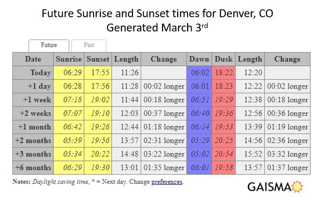
Colorado CoCoRaHS Winter Recap/Welcome to Spring
You made it! Meteorological winter (December-February) has ended. Cold weather is not entirely
behind us, but every sunny day is a longer and brighter day than the day before it. So long and good
riddance, 4:40 PM sunsets. There is now twilight past 6:00 PM. We start daylight savings time in just two
days. We will lose an hour, but gain sunsets of 7:00 PM or later for the next six months.

Figure 1: Table of daylight hours for various timescales for Denver.

How can we best recap our weather for winter 2019-2020? What did CoCoRaHS teach us?

Perhaps one of the most interesting things about winter this year is it seemed to start early. In my last
newsletter, I spoke about Colorado experiencing its warmest September on record. Wouldn’t you just
know we would have our 3rd coolest October on record? November brought us more of a mix, but some
of the best snow of the winter.

Meteorological winter 2020 (DJF), on the whole, may have been shockingly normal for Colorado. We
often espouse that “normal” conditions are the blended results of many abnormal years. When
precipitation is normal, that’s… a little weird! We still saw our share of spatial variation. This winter was
a good one for snow in the northern Rockies. We ended dry in the southwest and northeast corners of
the state (figure 2). It’s just about impossible to have normal conditions everywhere across the state.
Breckenridge Ski Resort and Copper Mountain recorded their wettest Februaries on record.
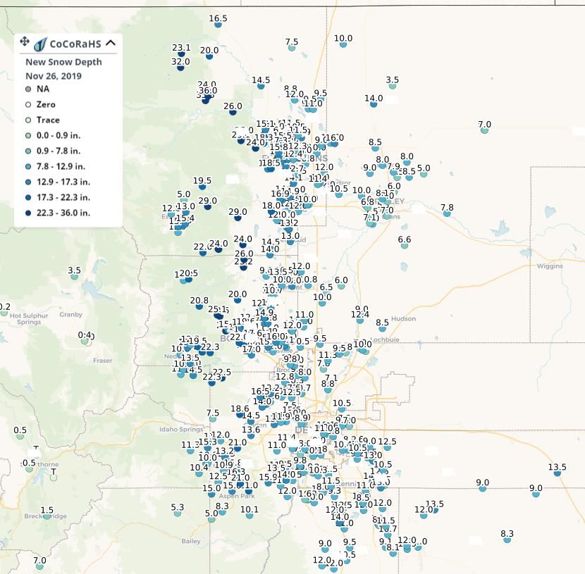
Figure 2: Map of winter (DJF) precipitation anomalies for Colorado 2020.

Maps like the one shown above (figure 2) would not be the same without your data. This product, and
many others like it, make use of precipitation grids from the PRISM Climate Group. PRISM is possibly our
biggest data user. They seek to understand our climate in the most detail possible, and CoCoRaHS
precipitation measurements are used heavily in their map-making process.

Best of CoCoRaHS winter 2020
Last year was a big snow year for the mountains. Our biggest “winners” for snowfall were generally in
the San Juans (they may not have felt like winners by May). The northern mountains lead the charge on
snow this winter. Two of you have eclipsed the 200” of snowfall mark for the season. One in the
Steamboat area, and the other on the Grand Mesa. Half of our top ten snowfall observers for the season
are in the Steamboat area.

Many of us had a fast start for snowfall this year, eclipsing average snowfall totals for October and
November. Our highest 24hr snowfall reports for the year so far came just two days before
Thanksgiving, hitting the northern Front Range harder than anywhere else in the state (figure 3). The
highest totals were in the foothills just west of our population centers. Several stations west of
Livermore, CO received three feet in one day. These are impressive totals, but did you know that the
highest verified single day total in Colorado is nearly seven feet?
Phtoto 1: Me at the 7PM weather observation at the Colorado State University station on November 25th, 2019.
Don’t worry. I’ve had a haircut!

One interesting aspect of this blizzard was the time of year, just under one month until the winter
solstice. This meant the next six weeks would be the six weeks with the least sunlight. Furthermore,
water content in the pre-Thanksgiving storm was high. I measured more water content in the snow that
day than is normal in December, January, and February combined in Berthoud. For those reasons: 1.
High water content, and 2. Short days, it seemed this snow would linger longer than we’re used to. It
did. The CSU campus weather station (photo 1) would have measurable snow on the ground for the next
40 days. There are still piles from shoveling on my north-facing front lawn. I estimate I moved one and a
half metric tons of snow that morning.
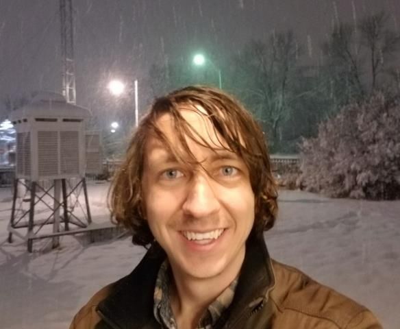
Figure 3: 24-hr northern Colorado snowfall analysis for November 26 th, 2019 using CoCoRaHS data.
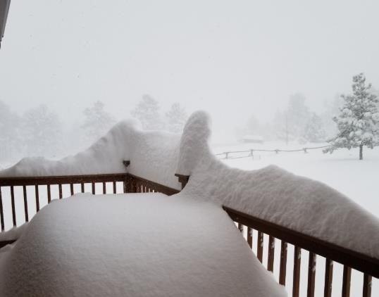
Photo 2: Picture of winter wonderland from November 26th, 2019 from CoCoRaHS observer in Livermore.

Long spells of snow cover are normal in the mountains. However, they’re not the norm for the urban
corridor. There are a few reasons our snow often melts quickly: 1. Seasonality. For many of us, March is
the snowiest month on average. March and April are when we are most vulnerable to blizzards. The sun
is also quite bright this late in the snow season, and the days long. It is easy for temperatures to rebound
quickly. 2. Chinook winds. When storms track across a mountain range the air does some interesting
things on the downwind side. It will often a) accelerate due to gravity as it flows down the
mountainside, and b) warm up through compression. These fast-moving, warm winds have been known
to eat as much as a foot of snow cover in one day. It would be fun to explore chinooks in more detail.
Maybe next time. 3. Cloud cover. Even in winter, Colorado usually has much sunnier weather than other
snowy parts of the county (e.g. Northeast and Upper Midwest). We aren’t strangers to wintry skies, but
these conditions don’t often last for days on end.

Colorado was subject to another impressive snow event in the first half of February. Steamboat Springs
received over 30” of snowfall over the 5-day period from February 6th to 10th. Other parts of the
northern Rockies from Garfield to Summit County also fared quite well. Glenwood Springs stations
recorded upwards of two feet over the same time frame. While it was more of a mountain event, snow
totals on the urban corridor did outperform the forecasted values.
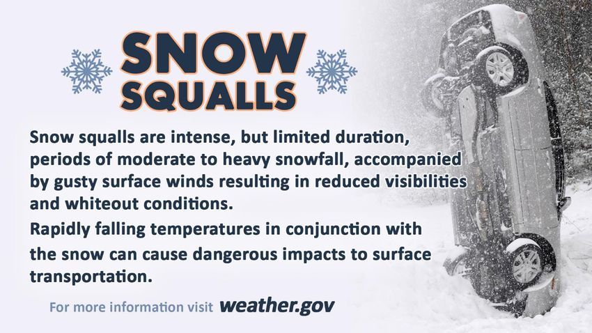
Figure 4: Map of northern Colorado snow depth on February 8 th, 2020 using CoCoRaHS data.

Snow Squalls
On the morning of Monday, February 24th I went through my normal routine of walking the dog, feeding
the dog and cat, and then checking the rain gauge. This morning I was saddened to see that no snow had
fallen overnight, despite an expectation of an inch or two. It had snowed down near the Palmer Divide
on Sunday, but the snow had missed me. Not but two minutes after checking my guage, I received a
“snow squall warning” on my phone from the National Weather Service forecasting office in Boulder.
Sure enough, it began to snow hard. The snow produced near-whiteout conditions for the better part of
10 minutes, and then just like that, it was over. The accumulation was only 0.03” of precipitation, and
0.5” of snowfall. It was lucky I was still home to observe the accumulation as winds continued to howl
for hours after the snow. The ground quickly dried.

Snow squalls are not new, but this warning system is. The National Weather Service in Boulder just
began issuing snow squall warnings this winter. Their explanation is given in the infographic below.
Figure 5: Snow squall infographic from NWS Boulder.

I cannot speak for the weather service, but in my experience, the reactions of people to these new
warnings has been mixed. For many, the alerts seem welcome, perhaps even novel or exciting. I have
also spoken with several folks who feel as though this is a waste of our emergency broadcast system. To
their credit, a snow squall is unlikely to have consequences if you aren’t traveling. What’s so bad about a
short burst of snow while sitting in your office chair at work? It is easy to see how warning a squall could
be viewed as “crying wolf.” However, snow squalls have been proven to rapidly reduce visibility,
degrade road conditions, and catch drivers unaware. This is a dangerous combination; one that results
in accidents and fatalities. Communicating such hazards to us in a timely and clear manner, so accidents
and fatalities do not occur, is manifestly a part of the National Weather Service’s obligation to taxpayers.

What should you do if you receive a snow squall warning while driving? The short answer is to be careful
and use common sense. Often times our schedules aren’t very flexible, so you may feel as though you
have limited capacity for avoiding the danger. But do keep in mind that snow squalls are typically short-
lived. If your schedule allows for it, stop for a bite to eat or a cup of joe until the warning has expired.
The worst danger will likely pass soon. Afterall, we plan accordingly when warned of a blizzard or severe
thunderstorm. Is this approach so different?

March Recruiting Drive
Some of you may have noticed that March is an important month for CoCoRaHS. This is the time of year
where we conduct a national recruiting effort. Drives like these are instrumental in ensuring our long-
term success. As always, we need your help. High pressure sales pitches are not my forte, just please
consider doing the following: Next time it rains or snows, and you enter a conversation about the storm,
consider sharing your CoCoRaHS experience. You can always send your inquisitive friends my way for
more information.
More importantly than anything, thank you so much to each and every one of you who have made this
quirky network a part of your routine. You make the CoCoRaHS family much more special than we could
have dreamed 25 years ago.

Breckenridge snowfall reference: https://theknow.denverpost.com/2020/02/25/breckenridge-300-inch-
snowfall-milestone/234322/
You can also read