Community - Kea Project Plan - Aoraki/Mt Cook - Kea Conservation Trust
←
→
Page content transcription
If your browser does not render page correctly, please read the page content below
Community – Kea Project Plan
                                        Aoraki/Mt Cook

Funded by: Department of Conservation Community Fund (DOC-CF)
Period: 1 November 2015 – 31 October 2017.

Key contact person: Kea Conservation Trust – Tamsin Orr-Walker – info@keaconservation.co.nz; Ph
0274249594

Aim
The aim of the Community – Kea Project Plan is to i) facilitate long-term community kea
conservation initiatives and ii) to change the way we think, act and live with kea in our communities.
This will be actioned through development of collaborative Community – Kea Project Plans across
the South Island. The Aoraki/Mt Cook plan, will address concerns specific to the local community
and threats to the resident kea population.

Project Background
This initial project plan outline has been developed as a result of discussions with communities
during the Kea Conservation Trust’s (KCT) Winter Advocacy Tour - 20 July – 3 August 2015. The tour
was funded by Dulux and supported by Department of Conservation (DOC). The tour theme,
“Building a future with kea”, aimed to promote a new MOU between communities and kea. This
initiative is in line with the new Strategic Plan for Kea Conservation (refer attached document),
objective 3: to i) increase positive perceptions of kea and reduce conflict and ii) facilitate formation
of community led kea conservation initiatives.
Local Community – Kea Project Plans will be activated by two Community Engagement Coordinator’s
(CEC’s) based in the following areas:
1) Upper half of the South Island: Northern region (Nelson/ Motueka/ Kahurangi), Central North
(Nelson Lakes/ Murchison/Arthur’s Pass/Christchurch/Mt Hutt) and upper West Coast (Greymouth
and Hokitika). There is also the potential to include Kaikoura at a later date (the eastern most
population of kea).
2) Lower half of the South Island: Lower West Coast (Franz/Fox Glaciers and Haast), Central South (Mt
Cook, Wanaka/Mt Aspiring and the Routeburn/Dart/ Queenstown areas) and Fiordland (Te Anau/
Milford/Murchison mountains).
Each project plan, will be developed in detail over the next two years and will involve creation of
an active volunteer network and facilitation of funding streams (external and internal). The plans
will take into account eight threats, actual and potential, to the wild kea population which have
been identified by kea researchers.
                  1) Predation by introduced mammals
                  2) Lead in kea habitat (e.g. flashings and lead-head nails, tyre weights, lead shot)
                  3) Poorly-deployed pest control devices (e.g. poison baits and traps laid for pest
                     control and aerial 1080 operations)
                  4) Avian diseases
                  5) Climate change (e.g. changes in predator abundance, food availability and
                     habitat quality)
                  6) Accidents with human objects (e.g. motor vehicles, snow groomers, rubbish
                     bins, electricity sub-stations)

Kea Conservation Trust                          Draft v1                                   February 2016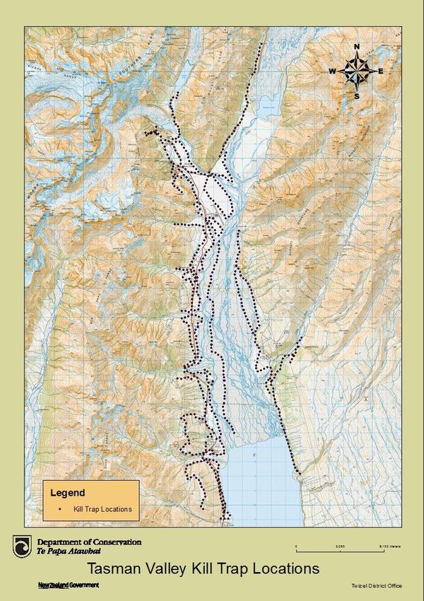
7) Destruction/removal of nuisance individuals (permitted or illegal)
                 8) Illicit trade in wildlife
Threat focus and mitigation will be area and resource dependant and take into account community
interests, expertise and support.

Aoraki/Mt Cook
Aoraki/Mt Cook village is located adjacent to the National Park of the same name which covers an
area of 700km2. The NP lies on the eastern flanks of the Southern Alps in the Canterbury region and
is bordered by Westland Tai Poutini National Park along the Main Divide. Together they form part of
Te Wahipounamu South Westland World Heritage Site (DOC).
The area was gazetted as a national park in October 1953 and includes 19 of NZ’s 20 peaks over
3,000 metres, including the tallest, Aoraki/Mt Cook at 3,753m. Glaciers (including most notably the
Tasman Glacier) cover 40% of the park. Most of the area is above treeline (ie > 1300m) and as a
result alpine vegetation predominates with little forest cover. In addition to native fauna (birds (such
as kea, rock wren and the critically endangered kaki/black stilt), geckos and invertebrates), the area
is home to introduced browsers such as red deer, chamois and tahr making it a mecca for hunters.
Over 250,000 visitors flock to the area each
year (Booth and Cullen, 2001) for a range
of activities including hunting in the 5
designated blocks, mountaineering,
tramping, skiing, kayaking, and scenic
flights to the glaciers and over the
Southern Alps.
The village has around 300 residents during
the summer months (Reid, 2008) and is the
gateway to the National Park. It is extremely
remote and can be reached by road in just
under 4 hrs from Christchurch to the north
east and 3 hrs from Queenstown to the
south. It is not directly accessible by road
from the west coast.
The village is geared to supporting tourism
and buildings include accommodation
(backpackers versus the Hermitage lodge),
the DOC visitors centre and support
buildings, the Sir Edmund Hillary Alpine
Centre, cafes, resident accommodation,
aircraft buildings and the local school
(which opened in 1959). The school caters        Fig 1. Aoraki/Mt Cook area in relation to the west coast
for approximately half a dozen students          and Lake Pukaki.
annually of primary school age.
Aoraki is an extremely important area to Ngai Tahu. “Aoraki represents the most sacred of
ancestors, from whom Ngāi Tahu descend and who provide the iwi with its sense of communal
identity, solidarity and purpose.” DOC 2016. Although it is considered tapu to climb onto what is
considered the head of the Ancestor, mountaineers from all around the world visit the park each
year specifically to scale NZ’s tallest peak. The first attempt to climb Aoraki/Mount Cook was made
in 1882 by an Irishman with two Swiss guides but it was not until 1894 that the summit was reached,
by three New Zealanders: Tom Fyfe, Jack Clarke and George Graham (DOC, 2016).

Kea Conservation Trust                          Draft v1                                 February 2016
Local Conservation Efforts
There is extensive predator control being carried out in the area by DOC and Aoraki volunteers.
These include two DOC projects - the Tasman Programme and Project River Recovery (PRR) as well
as volunteer trapping in and around Aoraki Village, Red and Sealy Tarns, the Hooker and the Upper
Tasman. The Tasman programme has been running for 12 years and was set up to see if trapping on
a large scale (20,000 ha) could make a difference (refer map below). A total of 1,482 traps are used
over this area.

Kea Conservation Trust                        Draft v1                                February 2016
In addition to predator control work, the Kaki/Black Stilt captive breeding programme is located near
twizel. Kaki are listed nationally critical (23 birds in 2012) (information from Dean Nelson, DOC
Twizel). The Eastern Falcoln Trust (EFT) also monitors falcon in the local area.
Table 1. Location of conservation work carried out by conservation groups around Aoraki/Mt Cook
Group Location Activity Trap #s Focal species
DOC Twizel Species Recovery - Kaki/Black ? Kaki
stilt captive breeding
programme
Eastern Falcon Aoraki and Monitoring programme ? Falcon
Trust surrounds
Project River Tasman Trapping Predator control – trapping ?? Protecting
Recovery area (including Red programme. braided river
(PRR) – (DOC) and Sealy Tarns) systems
funded by
Meridian and
Genesis
Tasman The lines up to Red Predator control - Kill traps 350 (150’s), 300
Programme and Sealy Tarns include DOC 150’s and 250s (250’s),
and up the Hooker (targeting stoats, ferrets and
77 Timms, 600 (leg
to the third rats), Timms, Victor and Twizel
hold victor 1.5 soft
swingbridge Cat traps (all targeting cats
jaw), 155 (Twizel
and/or hedgehogs). Victor leg
cat traps
holds operational for 10 days
(conibear))
only annually in winter.
KCT Mt Cook Village Kea nest monitoring n/a Kea
and surrounds
Aoraki Aoraki Village, Red Predator control - community ??
Volunteers and Sealy Tarns, volunteer checking of traps
the Hooker and
Upper Tasman
Figure 1. Location of individual organisations carrying out predator control work
Aoraki/Mt Cook Kea
Aoraki/ Mt Cook kea have been the subjects of a number of research projects. Vienna University first
began studying kea behaviour at Mt Cook village in 2002 and visited the area annually for almost a
decade. 36 kea were caught and banded within the first year. Although other researchers have
encountered these birds, the bands are now unreadable. Anecdotally, reports of community
concerns were raised about whether this research was encouraging inappropriate kea behaviour (ie
scavenging in rubbish bins) suggesting a possible conflict issue with kea in the area.
Kea were being tested for blood lead levels by Aoraki/Mt Cook DOC prior to 2006 but the severity of
the issue wasn’t realised until research on lead poisoning began in earnest in 2006-2010. This lead to
wide spread monitoring of kea across the South Island from 2006 by DOC. At this time an
investigation into sources of lead in the NP and surrounds was also initiated (DOC). A total of 42 kea
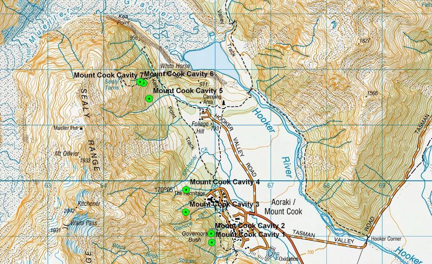
Kea Conservation Trust Draft v1 February 2016were tested for lead exposure in the NP (Reid et al. 2012). All were found to have detectable blood lead levels, 32 considered elevated (i.e. levels suggestive of lead poisoning) (K. McInnes, DOC, unpubl. data). Kea with elevated blood lead levels were also found to be more exploratory (also linked to social hierarchy and presence of conspecifics) (Reid, 2008). Additional analysis of 12 dead kea from the NP area (sent to Massey University for diagnostic pathology between 2001 and 2008) 5 were diagnosed with lead poisoning (B. Gartrell, Massey University, unpubl. data). . Lead toxicity in kea has now been found to be widespread throughout the species range in areas where kea and humans overlap (McInnes, 2010). Although an effort to remove lead materials from the village was driven by DOC, buildings containing lead nail heads and flashings have since been discovered, most recently in the school building in 2014. This has since been removed but raises the question as to whether all lead has been correctly identified and removed. As such, the status of lead in the areas buildings needs to be updated and ideally a follow up study to ascertain lead levels in kea to ensure the population is safe from this threat. The KCT monitored 7 known kea nests around the Mt Cook Village area in November 2012. These nests had first been discovered by the Vienna Institute research team. A further nest was discovered during the monitoring effort. Cameras were set up at two cavities which showed some sign of kea visitation, however none of the monitored cavities showed any indication of breeding activity. Kea have also been caught on film scavenging on a dead cat at an Eastern Falcon Conservation Trust (EFCT) hide. Footage showed a kea chasing away a falcon in this instance. Scavenging of carcasses which may have residual poison may be a potential issue for kea. No kea deaths have been reported as a result of predator control. Other than lead poisoning, electrocution is known to be a threat to local kea. In January 2013, 5 kea were electrocuted at an Alpine Energy substation located at Mount Cook just behind Unwin Hut (NZ Alpine Club lodge). This is where all the power for the village goes underground. A falcon was also killed at this time. Unofficially, DOC has also received confirmation that Alpine Energy workers Kea Conservation Trust Draft v1 February 2016
previously removed 2-3 kea from inside the substation fence, but didn’t notify DOC (Slatter, 2013
pers comm). The substation is due to be upgraded by 2018 but it is not known whether this will
reduce the risk to kea to zero or whether the current steps to minimise risk are of any value in the
meantime. Additionally it is not known if this is an isolated case or whether substations within kea
territory pose a significant risk to kea (and falcon) generally.
Other causes of kea injury and death in the area are currently unknown but may include issues with
predator control methods (kill traps/poisons), ingestion of other foreign materials or vehicle strike.
Project Plan Focal Areas
Discussions with the community and researchers over the years as well as recent meetings with the
local community during the 2015 Winter Advocacy tour, highlighted the following areas locals
wished to get involved with in regards kea conservation: i) Identification of local kea population
status, ii) identification and reduction of local threats (predation, pest control, lead, electrocution
and conflict etc), iii) care of injured kea (through support of local community volunteer efforts), iv)
local perceptions of kea and v) and education of visitors to the area to reduce conflict and exposure
of kea to dangerous situations. These focal areas may be added to in the future.

    i)      Identification of local kea population status
Aim: monitoring of known kea nests to ascertain population status and predation threat over years.

Method: Check known kea nests for activity and if confirmed active place cameras outside and inside
nests to monitor progress. Follow up any chicks to ascertain survivorship and as funds allow, attach
radio transmitters to resident adults, band all progeny prior to fledging to enable visual ID, and enter
all data into the main kea database. This would be mainly done by the KCT but the community and
DOC staff could support this with identification of kea nesting activity and other sightings (Nelson,
DOC Twizel).

Funding: Funding to be secured for this project. Project management time will be supported via the
DOC CF.

    ii)     Identification and reduction of local threats with particular attention to the following:
Pest Control –

Aim: This project will look to a) Identify level of nest predation at monitored nests, b) support and
expand local pest control efforts to benefit nesting kea, and c) minimise unintentional injury and
deaths to kea (both trapping and poison methods).

Method: Develop a plan to maximise the benefits of pest control to nesting kea and minimise any
negative impacts on the species.

Funding: DOC CF funding to develop an initial plan to action the above project.

Lead Poisoning – Mt Cook kea have previously been found to have very high blood lead levels
(McLelland et al. 2010, Reid et al. 2012). As a result DOC investigated lead sources in the area and
began its removal. As a follow up to this work, we propose to do a survey of lead in the area and test
kea for lead to confirm lead free status. This information would provide valuable follow up to the

Kea Conservation Trust                          Draft v1                                 February 2016
research previously undertaken by DOC and other researchers and encourage other communities to
remove lead from kea environs South Island wide.
Aim: a) confirm presence/absence of lead within Aoraki/Mt Cook village and surrounds and b) test
blood lead levels in local kea.
Method: a) check DOC records for lead removal; survey non- DOC buildings for lead. Where lead is
found, develop a plan for lead removal and apply for funding and community support to action this
(materials and volunteer input); b) test all nesting kea and their offspring for lead (refer project i)) in
collaboration with DOC vet (who has specific experience in this area).
Funding: a) initially funded through the DOC CF (CEC position); b) funding for lead testing to be
secured as required.
Electrocution - due to the number of kea killed (reported and unreported) at the substation by
Unwin Hut, a full analysis of risk to kea of this particular substation (and any others in the area) to be
carried out. The outcomes of this project may result in a full survey of substation risk to kea across
the species range.
Aim: Fully understand the risk that substations pose to Mt Cook kea.
Method: Access all records of injury/death to kea (and other birdlife) within the local area.
Investigate risk minimisation actions taken by Alpine Energy and discuss with the company their
policy for reporting any wildlife injuries/mortalities.
Funding: Initial investigation will be will be supported through the DOC CF Community - Kea Project
Plan.
iii) Care of Injured Kea
Aims - In the first instance a fund is to be set up to take donations to support volunteer efforts to
provide short term care for kea (prior to receiving specialist medical support), and to transport
injured/ sick birds for medical treatment.
This will be driven by the KCT and be used for the following purposes:
Reimbursement of travel costs (petrol) on production of receipt/s;
Purchase of any equipment (carry cages etc), expendables (food and hydration) to support
holding and transport of kea (any proposed purchases must be cleared first to ensure there
are sufficient funds available);
Process for transporting kea to specialist veterinary facilities (Massey University, The Nest
(Wellington Zoo)), Vet Ent Queenstown or South Island Wildlife Hospital);
Develop local SOP with community stakeholders for dealing with injured kea.
Funding – a crowd sourced funding page to be set up to collect funds to support volunteers
transporting kea to receive medical treatment. This fund will be promoted on a regular basis
throughout the year.
Kea Conservation Trust Draft v1 February 2016Development of Injured kea SOP will be supported through the DOC CCPF Strategic plan funds and
DOC CF Community - Kea Project Plan.
iv) Education of local residents and visitors to the area to reduce conflict and exposure of
kea to dangerous situations.
Aims – to increase public awareness of the endangered status and threats to kea and to reduce the
incidence of inappropriate behaviour and conflict. Main education points to cover a) kea are
endangered and fully protected, b) no feeding of kea, c) conflict resolution and d) call to action. This
will be achieve through the following methods:
Supply of kea education resources to outdoor focused companies
Development of appropriate resources for local towns where necessary
Promotion of kea sightings reporting (via website or phone app)
Promotion of kea proofing database and conflicts programme
Funding – this project will be funded through the DOC CF – Community – Kea Project Plan.
References
Booth and Cullen, 2001. Managing Recreation and Tourism in New Zealand
mountains. Mountain Research and Development Vol 21 No 4 Nov 2001: 331–
334
DOC, downloaded 7 March 2016 from http://www.doc.govt.nz/parks-and-
recreation/places-to-go/canterbury/places/aoraki-mount-cook-national-park/
Reid, C, McInnes, K, McLelland, J.M, Gartrell, B.D. 2012. Anthropogenic lead (Pb)
exposure in populations of a wild parrot (kea Nestor notabilis). New Zealand Journal
of Ecology 36(1): 56-63.
Reid, 2008. Exploration Avoidance and an Anthropogenic Toxin (Lead Pb) in a Wild
Parrot (Kea: Nestor notabilis). Unpubl. MSc thesis, Victoria University of Wellington.
McLelland, J. M., Reid, C., McInnes, K., Roe, W. D., & Gartrell, B. D. (2010). Evidence
of lead exposure in a free-ranging population of kea (Nestor notabilis). Journal of
Wildlife Diseases, 46 (2), 532-540.
Kea Conservation Trust Draft v1 February 2016You can also read