The 1755 earthquake in the Algarve (South of Portugal): what would happen nowadays?
←
→
Page content transcription
If your browser does not render page correctly, please read the page content below
Adv. Geosci., 14, 59–63, 2008
www.adv-geosci.net/14/59/2008/                                                                          Advances in
© Author(s) 2008. This work is licensed                                                                 Geosciences
under a Creative Commons License.

The 1755 earthquake in the Algarve (South of Portugal):
what would happen nowadays?
F. Tedim Pedrosa and J. Gonçalves
Faculty of Arts of University of Porto, Portugal
Received: 15 June 2007 – Revised: 11 October 2007 – Accepted: 12 October 2007 – Published: 2 January 2008

Abstract. The 1755 Lisbon earthquake, which reached a              1   Introduction
magnitude of 8.5, remains the most powerful and destructive
to hit Europe so far. Within minutes, many lives were lost,        On the 1 November 1755 there was a magnitude 8.5 earth-
populations displaced, livelihoods, homes and infrastructures      quake in Lisbon, one of the most important European cities
were destroyed. Although frequently associated to the city         of the time. This earthquake remains the most powerful and
of Lisbon, one of the most important European cities at the        destructive to hit Europe so far. Although associated with the
time, this earthquake caused similar damage and casualties,        city of Lisbon, the earthquake caused similar or greater dam-
if not greater, in the southwest of the Algarve, where the seis-   age and casualties in the Algarve region located in the south
mic intensity was estimated at IX-X Mercalli Intensity Scale.      of Portugal, where the seismic intensity was estimated at IX-
Some time later a tsunami increased the number of victims          X on the Mercalli Intensity Scale (Sousa, 1919; Baptista et
and the amount of damage. In some locations the tsunami            al., 1998; Chester, 2001).
caused greater destruction than the earthquake itself. The            The earthquake epicentre is known to have been offshore
tsunami hit both coasts of the North Atlantic; however, the        but the exact location remains a controversial and debated
more destructive damage occurred in the Portuguese coast,          issue. The plate tectonics of the region are complex, with
south from Lisbon, in the Gulf of Cadiz and in the Moroc-          several independent blocks/plates, moving at slow relative
can coast. The downtown of Lisbon was flooded by waves             motions and producing numerous structures showing signs
that reached a height of 6 m. The water flooded an area with       of recent deformation (Gutscher, 2005).
an extension of around 250 m from the coast. In the South-            There are several proposals of tectonic sources for the
west part of Algarve the waves reached a height between 10         1755 earthquake, for instance the Gorringe Bank (Johnston,
and 15 m and the flooded area was much larger. Through the         1996) a structure large enough to generate the earthquake,
analysis of recent research works on the assessment of the         although incapable of producing a tsunami similar to that
1755 tsunami parameters and the interpretation of the more         in 1755 (Costa et al., 2005); the Marquis of Pombal Fault
reliable historical documents, it is our intention to analyse      (Zitelline et al., 2001); a potential composite source includ-
the destructive power of the tsunami in the Algarve and de-        ing the Marquis of Pombal Fault and the Guadalquivir Bank
limit the flooded area. Using simple techniques of simulation      (Baptista et al., 2003); and most recently the subduction
it is our intention to assess the impacts nowadays of the oc-      fault plane in the Gulf of Cadiz (Gutscher, 2004) that is a
currence of a tsunami similar to the one that hit the Algarve      locked seismogenic zone with active subduction (Miranda et
in 1755, which would probably affect a greater number of           al., 2005) with sufficient dimensions (roughly 200×200 km)
people, buildings and infrastructures. This assessment is an       to generate an earthquake of moment magnitude M=8.64
important instrument not only in terms of disaster prepared-       with a co-seismic slip of 10 m and a recurrence interval of
ness but also for the integration of risk mitigation measures      2000 years (Gutscher, 2005). A combination of the subduc-
in land use planning.                                              tion fault plane and an additional source further to the NW
                                                                   may offer the best explanation for the historically observed
                                                                   tsunami and seismic intensity patterns (Gutscher, 2005). It is
                                                                   now clear that the geodynamic context and the rupture mech-
                                                                   anism of the 1755 earthquake are quite different from those
Correspondence to: F. Tedim Pedrosa                                implied in the 28 February 1969 earthquake, which also gen-
(fpedrosa@letras.up.pt)                                            erate a tsunami (Table 1).

Published by Copernicus Publications on behalf of the European Geosciences Union.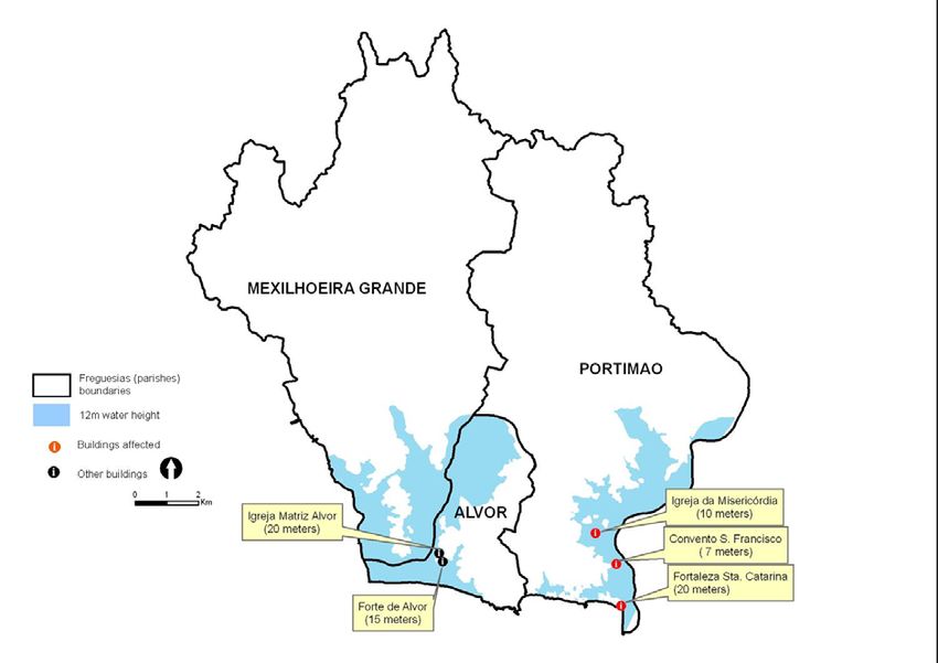
60 F. Tedim Pedrosa and J. Gonçalves: The 1755 earthquake in the Algarve (South of Portugal)
Table 1. The greatest earthquakes in Algarve.
Date Latitude Longitude Estimated Magnitude Occurrence of Tsunami
63 BC 36.0 N 10.7 W 8.5 Probably a tsunami (Oliveira, 1986)
47 BC ? ? 8.5
33 BC ? ? 9.0
309 37.0 N 11 W 7.0
382 36.5 N 9.5 W 7.5 There was a tsunami (Brito, 1597)
1309 36.0 N 11.0 W 7.0
1356 36.0 N 10.7 W 7.5
1504 38.7 N 5.6 W 7.0
1531 38.95 N 9.0 W 7.1
1719 37.1 N 8.5 W 7.0
1722 36.9 N 7.6 W 7.0 Tsunami
1755 ? ? 8.5 Tsunami
1909 38.9 N 8.8 W 7.6
1969 36.2 N 10.6 W 7.5 Tsunami – intensity II
Source: Martins and Mendes-Victor, 2001
In this paper, it is our purpose to delimitate the area flooded area. However, we are not entirely sure of the exact
flooded by the 1755 tsunami in the Algarve coast and to coastal morphology of the time, so it is particularly impor-
assess the impacts nowadays of the occurrence of a similar tant to determine the location of churches and other buildings
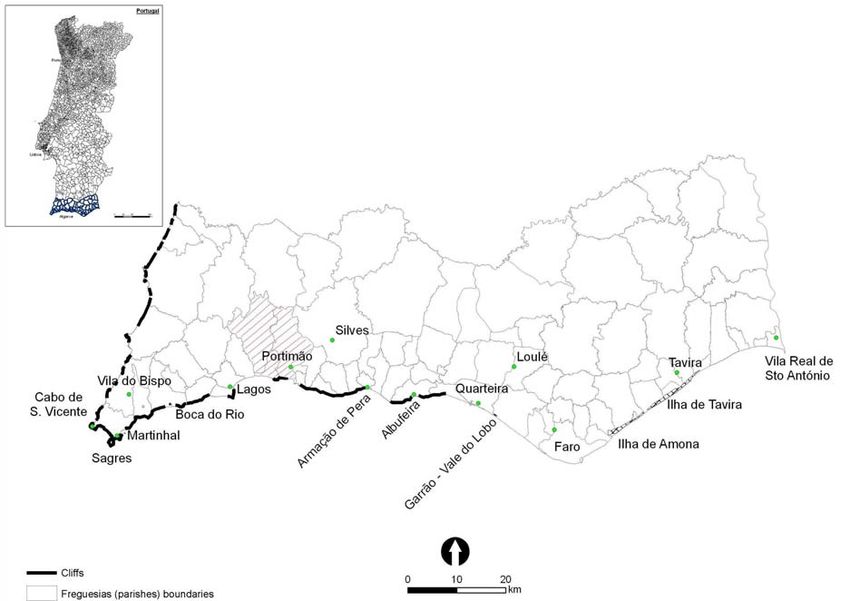
event. We selected as a case study the municipality of Por- damaged by the force of the waves, in which the maximum
timão (Fig. 1), which was one of the most devastated. height of the water is known, in order to validate our method-
We want to show that the determination of the flooded area ology. A good example is the Igreja da Misericórdia, located
is an important instrument not only in terms of disaster pre- ten meters above sea level. The water, inside this building, is
paredness but also for the integration of mitigation measures said to have reached 2.64 m high. So the height of the wave
in the strategy of development, land planning and manage- was determined based in three types of information: histor-
ment of the coastal area. ical description of the wave height, extension of penetration
of the tsunami and reports of destroyed buildings.
Also important was the Digital Terrain Model (DTM) built
2 Data and methodology for the municipality of Portimão. The determination of the
flooded area depends on the accuracy of this model. The
Although the earthquake occurred in 1755, the devastation
DTM was built based in topographic information at 1/5000
is well documented in engravings, reports in newspapers of
scale, resulting in a Triangulated Irregular Network.
the time, and letters between several distinguished people.
After determining the probable height reached by the wave
Prime Minister Melo ordered a survey, known as the Mar-
in certain areas of the municipality, we used the analysis ca-
quis of Pombal Survey, to be answered by the priests of all
pacity of Geographical Information Systems technology to
parishes of the kingdom and which contributed immensely
determine the area likely to have been flooded in the 1755
to a scientific analysis of the earthquake, and the disaster
tsunami. The next step was cross-referencing this infor-
response. However, because the answers to the Marquis of
mation with the current data available regarding population,
Pombal Survey regarding the Algarve remain unknown, we
built-up area, and equipment using overlay operations.
based our research mainly on another survey sent to all the
parishes that included a question regarding the devastation
level caused by the earthquake and the state of current recon- 3 The historical data analysis
struction. Despite the questionnaire not including a question
directly related with the tsunami, the priests mentioned in The municipality of Portimão comprises the freguesias
their answers the damage caused by it. This survey is known (parishes) of Alvor, Portimão and Mexilhoeira Grande
as the Dicionário Geográfico (Geographical Dictionary) of (Fig. 2). The earthquake shaking reached the intensity VIII
1758, although is much more limited for the study of the on the Mercalli Intensity Scale in Mexilhoeira Grande and X
1755 earthquake than the earlier Marquis of Pombal Survey. in Alvor and Portimão (Sousa, 1919; Chester, 2001).
The information collected in historical documents about According to historical references in Alvor the sea inun-
the height of the waves and the extension of penetration of dated 660 m inland, nearly reaching houses at 30 m altitude.
the tsunami on land provided a basis to the delimitation of the The chapel of Nossa Senhora da Ajuda, located on the beach
Adv. Geosci., 14, 59–63, 2008 www.adv-geosci.net/14/59/2008/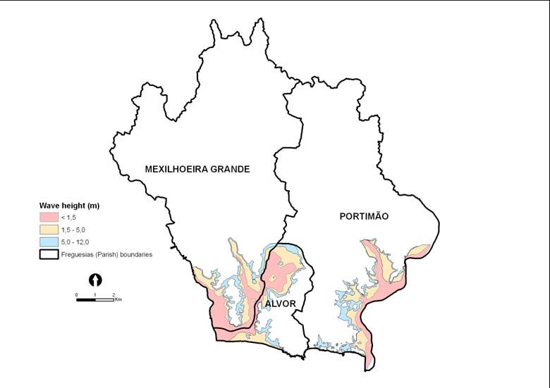
Source: Martins & Mendes-Victor, 2001

F. Tedim Pedrosa and J. Gonçalves: The 1755 earthquake in the Algarve (South of Portugal)                                                          61

Fig. 1. The localisation of the municipality of Portimão.
                                          Figure 1 - The localisation of the municipality of Portimão

by the harbour, was completely destroyed leaving no traces
of its foundations (Lopes, 1841).
   In the freguesia of Portimão the sea flowed inland, over-
topping the natural barriers, in some areas more than 880 m,
devastating the salt ponds of this village. Since then no salt
has been produced there (Dicionário Geográfico, 1758). The
harbour of Portimão forms a great mouth berthed between
two large rocks, in front of which are the fortresses of Santa
Catarina and São João. The first of the two was severely
damaged (Dicionário Geográfico, 1758) and the latter was
completely washed out (Lopes, 1841).
   Through the village of Portimão flowed successively
amazing waves, which advanced over 5km up the river. As
the waves advanced everything was destroyed. Several boats
were carried inland to such great distance that it was not pos-
sible to bring them back. Flooding occurred on the outskirts
of the village, destroying all the houses and drowning many                          Figure 2 – Historial buildings location and the delimitation of the flooded area
people, which had sought refuge in the river banks (Castro,              Fig. 2. Historial buildings location and the delimitation of the
1786).                                                                   flooded areain in
                                                                                        municipality of Portimão
                                                                                           municipality          as a consequence
                                                                                                           of Portimão           of the 1755 tsunami
                                                                                                                          as a consequence     of the
                                                                         1755 tsunami.
   From the accounts about the height of the wave we verify
that near the coast it must have got to 20 m high. It is said
that the water reached the village of Alvor which is located             above the sea, was completely destroyed. These references
between 20 to 30 m a.s.l., reaching the Fortress of Santa Cata-          were integrated in de map over the Digital Terrain Model
rina (20 m). The city of Portimão is protected by the rocks             (DTM). According to historical sources the height of 12 m
of Praia da Rocha, so it is probable that the wave did not               was considered a reliable height for most of the wave but it
reach the height of 20 m. The Igreja da Misericórdia is the             is possible that in small areas the wave could have reached
main source for the determination of the wave height. As                 higher heights as it happened in Fortress of Santa Catarina
previously referred this church is located 10 m above sea and            located on a cliff edge.
the water rise 2.64 m inside the building. Another building,
the Convento de São Francisco located, approximately, 7 m

www.adv-geosci.net/14/59/2008/                                                                                 Adv. Geosci., 14, 59–63, 2008
62 F. Tedim Pedrosa and J. Gonçalves: The 1755 earthquake in the Algarve (South of Portugal)
We estimate that approximately 5000 buildings would be
affected, many of which would be destroyed or severely dam-
aged, including hotels. However, the vulnerability of the
hotel units is highly variable. We identified 67 hotels, of
which 26 are located in the potentially flooded area. Some
of the newest resorts are located in highly susceptible areas,
as is the case of the hotel, restaurants and marina built in the
mouth of the River Arade, which would represent the first
structures to be struck by the waves of a tsunami.
In a disaster situation, the management of rescue means
and security forces is essential. From our analysis, it is pos-
sible to conclude that with a wave height of 12 m the struc-
tures of civil protection agents would not be severely dam-
aged. Only the police headquarters is located in a poten-
tially flooded area but fire-fighter brigades and other security
forces will not be affected.
When considering the health facilities, the primary care
health centres would be affected but not the hospitals. How-
ever, also located in the potential flooded area are the airport,
Fig. 3. The water height in 1755 tsunami: inverted model. the prison, and the local building of Red Cross.
In addition, the road network itself would be severely af-
Figure 3 – The water height in 1755 tsunami: inverted model
Based in the DTM, the lands with altitude below 12 m and fected and significant stretches of essential regional routes
near the coast had been identified, eliminating isolated areas would either be flooded or destroyed.
surrounded by lands higher than 12 m, producing a new DTM We can thus conclude that faced with a tsunami similar to
of the wave height (inverted) and in a polygon the flooded the 1755 event, the region would be considerably dependent
area (Fig. 3). on external rescue means.
These analyses are a summarised description of the vir-
tuosity of our approach to emergency planning, although it
4 The impacts of the 1755 tsunami nowadays is also possible to include other variables such as water and
electricity infrastructures. They help us to demonstrate the
The flooded area is inferred to have amounted to 23.75 km2 , population’s exposure to risk and the urgent need to develop
13% of the total surface of the municipality. This extent is protection mechanisms, including a greater attention to land
explained by the fact that this is a sandy coast with a reduced management efforts, especially as far as the location of pri-
number of cliffs and by the existence of two rivers, natural ority equipment is concerned, but also the establishment of a
boundaries of the municipality, serving as corridors allowing building code, because if there have been tsunamis in the Al-
the advance of the waves. garve in the past, another tsunami could occur in the region
Since 1755, two key factors have increased the vulnerabil- in the future.
ity of Portimão. Seaside settlement is no longer solely based
on local resources but on urbanization and tourism associated
with the attraction of enjoying living and vacationing literally 5 Conclusions
in front of the sea.
Nowadays, the potentially flooded area would put at risk Although the average return period of a tsunami similar to
approximately, 21 845 inhabitants, according to 2001 Census the one that hit the Algarve in 1755 is very great, probably
data. The area most damaged would without a doubt be the greater than 1000 years, it may occur at any time provided
low-lying area of the city of Portimão, affecting about 18 303 that the seismic source is totally or partially located in the sea
people. In the others parishes fewer inhabitants would be in and that the magnitude measures more than 7.5 (Costa et al.,
danger: 2403 inhabitants in Alvor and 1139 inhabitants in 2005). In that case a tsunami would rapidly arrive, meaning
Mexilhoeira. Since Portimão is an area where tourism is the that a rapid recognition and reaction would be necessary to
most important economic activity, we can conclude that the minimise the damage. In the 1755 event it is inferred that
population at risk would actually be much higher. Although the tsunami arrival time is 7 to 16 min after the earthquake
there is no statistical record of the temporary population and (Baptista et al., 1998, 2005). Thus, the delimitation of the
it varies tremendously during the year, if we take into con- flooded area is an important tool for emergency planning.
sideration the water and electricity consumption in certain It is obvious that the simulation we present here is valid for
seasons, it is possible to say that the population doubles in an earthquake with the same magnitude and tectonic source
some periods. as the 1755 event. Of course, other earthquakes with offshore
Adv. Geosci., 14, 59–63, 2008 www.adv-geosci.net/14/59/2008/F. Tedim Pedrosa and J. Gonçalves: The 1755 earthquake in the Algarve (South of Portugal) 63
epicentres but different magnitudes and locations will lead to Baptista, M. A., Heitor, S., Miranda, J. M., Miranda, P., Victor, L.
distinct flood heights and inundated areas. In fact, the 28 M.: Constrains on the source of the 1755 Lisbon tsunami inferred
February 1969 earthquake with a magnitude of 7.5 (Martins from numerical modelling of historical data on the source of the
and Mendes-Victor, 2001) or 7.9 (Baptista et al., 1998) and 1755 Lisbon tsunami, J. Geodyn., 25(2), 159–174, 1998.
epicentre on the Horseshoe Abyssal plain south of Gorringe Baptista, M. A., Miranda, J. M., Chierici, F., and Zitellini, N.: New
study of the 1755 earthquake source based on multi-channel seis-
Bank (Fukao, 1973) generated a weak tsunami that did not
mic survey data and tsunami modelling, Nat. Hazards Earth Syst.
put at risk the coastal communities in the Algarve. Sci., 3, 333–340, 2003,
Although we have not used modulation to assess the en- http://www.nat-hazards-earth-syst-sci.net/3/333/2003/.
ergy of the tsunami, the simple identification of the flooded Baptista, M. A. and Miranda, J. M.: Evaluation of the 1755 earth-
area is fundamental because the more extensive the area af- quake source using tsunami modelling, Proceedings of Interna-
fected is, the higher the height of the wave and the energy tional Conference 250th Anniversary of the 1755 Lisbon Earth-
transported are (Costa et al., 2005). quake, Lisboa, 574–577, 2005.
Also we must remember that run-up heights are not just Carvalho, A., Campos Costa, A., and Oliveira, C. S.: A Finite –
a function of distance from the epicentre. In 1755 run-up Fault Modeling of the 1755 Lisbon Earthquake Sources, Pro-
heights were variable at similar distances from the epicentre. ceedings of International Conference 250th Anniversary of the
No doubt some of this variance reflects imprecision in the 1755 Lisbon Earthquake, Lisboa, 578–583, 2005.
Costa, A., Andrade, C., Seabra, C., Matias, L., Baptista, M. A., and
historical data but unlike the timing of onset, run-up height
Nunes, S.: 1755 Terramoto no Algarve, Centro Ciência Viva do
is a reasonably well constrained parameter in the historical Algarve, Faro, 2005.
record (Mendes et al., 1999). The configuration of the coast, Dicionário Geográfico, Freguesia de Alvor, Arquivo Nacional da
state of the tide, and offshore bathymetry are also crucial fac- Torre do Tombo, 3, 375–391, 1758.
tors. Dicionário Geográfico, Freguesia de Vila Nova de Portimão, Ar-
We assess the potential impacts of a 12 m wave height but quivo Nacional da Torre do Tombo, 29, 1613–1628, 1758.
it is also possible to define several scenarios with obviously Dicionário Geográfico, Freguesia de Mexilhoeira Grande, Arquivo
different impacts. The delimitation of the flooded area be- Nacional da Torre do Tombo, 23, 1053–1056, 1758.
sides serving as a basis for the definition of scenarios and the Fukao, Y.: Thrust faulting at a lithospheric plate boundary. The Por-
determination of emergency planning tasks, may also serve tugal earthquake of 1969, Earth Planet. Sci. Lett., 18, 205–216,
as a guiding principle for land management. 1973.
Gutscher, M. A.: What caused the Great Lisbon earthquake?, Sci-
Acknowledgements. The authors thank the Municipal Council of ence, 305, 1247–1248, 2004.
Portimão for providing cartography at 1:5000 scale, which was Gutscher, M. A.: Whodunnit in 1755? New clues from Sumatra,
essential for the conduct of the research. from the seafloor off SW Iberia and from GPS, Proceedings of
International Conference 250th Anniversary of the 1755 Lisbon
Edited by: P. Fabian Earthquake, 568–573, Lisboa, 2005.
Reviewed by: D. Keefer and an anonymous referee Martins, I. and Mendes-Victor, L.: Contribuição para o estudo da
sismicidade da região oeste da Penı́nsula Ibérica, Publicação no.
25, Universidade de Lisboa, Instituto Geofı́sico do Infante D.
References Luı́s, Lisboa, 2001.
Mendes-Victor, L., Ribeiro, A., Córdoba, D., Persoglia, S., Pellis,
Baptista, M. A., Heitor, S., Miranda, J. M., Chierici, F., and G., Sartori, R., Torelli, L., Zitellini, N., Dañbeitia, J. J., and
Zitellini, N.: New study of the 1755 earthquake source based on BIGSETS Team: BIGSETS: Big sources of Earthquakes and
multi-channel seismic survey data and tsunami modelling, Nat. Tsunami in SW Ibéria, Eos Trans AGU, Fall meeting, T12B-01,
Hazards Earth Syst. Sci., 3, 330–340, 2003, 1999.
http://www.nat-hazards-earth-syst-sci.net/3/330/2003/. Oliveira, F. X. A.: A Monografia de Alvor, Editora Algarve em
Baptista, M. A., Heitor, S., Miranda, J. M., Miranda, P., and Vic- Foco, 1907.
tor, L. M.: The 1755 Lisbon tsunami; evaluation of the tsunami Lopes, J. B. S: Corografia ou Memória Económica, Estadı́stica e
parameters, J. Geodyn., 25(2), 143–157, 1998. Topográfica do Reino do Algarve, Lisboa, 1841.
Baptista, M. A.: Génese, impacte e propagação de Tsunamis na Zitellini, N., Mendes, L. A., Cordoba, D., et al.: Source of 1755 Lis-
Costa Portuguesa, Tese de Doutoramento, Universidade de Lis- bon earthquake, tsunami investigated, EOS, 26, 285–291, 2001.
boa, 1998.
www.adv-geosci.net/14/59/2008/ Adv. Geosci., 14, 59–63, 2008You can also read