Detecting the Attractive Spots of Hiking Tourism Based on Geo-tagged Photos: The Case of the Northern Outskirts of Guangzhou, China - ISOCARP
←
→
Page content transcription
If your browser does not render page correctly, please read the page content below
Shen, Ping                     Detecting Attractive Spots           54th ISOCARP Congress 2018
Liang, Jingyu                 Based on Geo-tagged Photos
Zhao, Miaoxi

     Detecting the Attractive Spots of Hiking Tourism Based on
     Geo-tagged Photos: The Case of the Northern Outskirts of
                         Guangzhou, China
                            Ping SHEN, Tongji University, China
                 Jingyu LIANG, South China University of Technology, China
                 Miaoxi ZHAO, South China University of Technology, China

Abstract

Hiking in the outskirts of mega cities as a kind of environmentally friendly and sustainable
urban tourism is becoming more and more popular in China. The trend of urban residents
participating in hiking in China appears to be relatively late comparing with that in Europe.
Therefore, the facilities and management for hiking tourism still need to be improved in China.
Hiking activities can help citizens keep physically and mentally healthy because it provides
the opportunity to experience the tranquility, solitude and pristine beauty of nature, which are
recreational qualities that contrast with the stress of urban life. So, going hiking frequently is
a green lifestyle. Since hiking activities are often carried out in outdoor areas with no regular
path, it is difficult to use traditional methods to research these activities, especially when the
research focus on large-scale area.
The social networking sites for hikers have emerged in China in recent years, which provide
opportunities to share geo-tagged photos when going hiking. These photos serve as a new
source of data for studying hiking activities. Considering that people take photos to record
attractions, geo-tagged photos reflect people’s memorable events associated with locations.
Therefore, these photos provide insights into hikers’ preferences and their interactions with
the surroundings. Based on these photos, a novel approach is presented to identify the spots
which attract the hikers through density analysis and to get the tags representing features of
the spots through image recognition.
In this paper, we made a case study of the hiking activities in the northern outskirts of
Guangzhou, China. This area is approximately 1797 square kilometers, having rich
ecological resources and attracting numbers of hikers. First of all, the shared geo-tagged
photos of the area from March 2010 to March 2017 were obtained. After screening, 13157
photos shared by the hikers were gained. Then, the hot spots attracting hikers were identified
through density analysis in GIS. After image recognition, tags representing contents of the
photos taken within 50m around the attractive spots were found out. Then top two
representative tags were selected for each attractive spot. These tags including “Mountain,
“Vegetation”, “Water”, “Rock”, “Building” and “Person”, introduce the types of the attractive
spots and the contents of the most photos taken by hikers when they stay. Finally, the
pattern of distribution of different types of attractive spots were studied and summarized. The
information of the attractive spots and the tags can serve as an important reference for
planning, governance and management of hiking tourism.
Keywords: geo-tagged photos; hiking tourism; attractive spots; representative tags;
Guangzhou, China

1. Introduction

The tourism sector which is already one of the fastest growing industries in the world is
currently undergoing extensive change (Sørensen & Sundbo, 2014). Among various ways of
tourism, hiking is becoming more and more popular in China. The rapid development of
outdoor activities and Internet have promoted the popularity of hiking tourism. Hiking in the

                                                1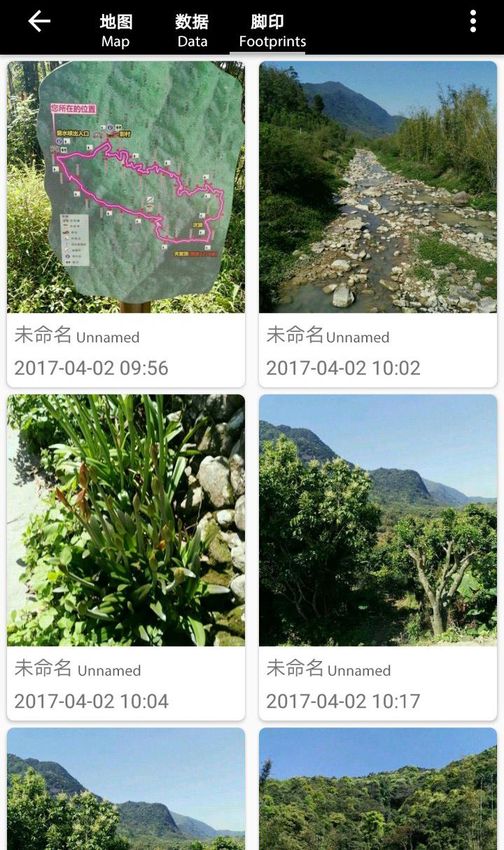
Shen, Ping                      Detecting Attractive Spots            54th ISOCARP Congress 2018
Liang, Jingyu                  Based on Geo-tagged Photos
Zhao, Miaoxi

suburbs of large cities is a typical type of eco-tourism. Citizens from large cities participate in
hiking in the outskirts of the cities in order to get exercise, rest and recreation. In this process,
they also achieve the purpose of understanding, enjoying and protecting nature. Many
developed countries have developed mature systems and commendable facilities for hiking
tourism. However, hiking tourism in China appears to be relatively late, and it is still
spontaneous. Therefore, the facilities and management for hiking tourism need to be
improved in China (Jin, et al , 2012).
The characteristics of tourists’ behavior are very important aspects in tourism research
(Beeco, et al, 2013). Understanding the tourists’ needs and activities is crucial for tourism
planning and management (Taczanowska, et al, 2014; East, et al, 2017). However, hiking is
often carried out in rural and natural environments so that traditional survey methods are
difficult to apply due to the area is lack of monitoring and some hikers lack map reading skills
or have difficulties in orientation.
With the development of technology, GPS is integrated into portable equipment, providing
new opportunities for tracking travel activities (Nielsen, et al, 2010). With the gradual
development of the social networking platform, many hikers share where they are and what
they see in the process of hiking by sharing geo-tagged photos on the social networking sites.
A large number of geo-tagged photos on the Internet provide a new and valuable source of
information for the study of tourists’ behavior (Orsi & Geneletti, 2013). The study of the
preference and behavior of tourists based on geo-tagged photos has become an important
topic in the field of tourism research and management. By analyzing geo-tagged images, we
can get information about the places that attract hikers (Arase, et al, 2010). These spots
often have charming landscape or interesting things. They are also places that are prone to
crowding (East D, et al, 2017). The planning and management of these places need to take
into account in terms of both viewing function and security protection.
This study attempts to collect the geo-tagged photos shared on the social networking sites
and obtain the attractive spots of hiking tourism through density analysis in the GIS. After
using image recognition technology to identify the contents of photos around the attractive
spots, the tags which represent the contents interested by the hikers can be gained. The
information of the attractive spots and the tags can provide a basis for planning and
management of the attractive spots of hiking tourism.

2.   Related Research Review

In academia, the study of outdoor tourism activities has a long history. In densely populated
areas, providing quality outdoor recreation areas is a particularly important topic. The design
methods that explore the balance of the needs of tourists and the services have attracted
plenty of attention (Bell, 2008). Traditional studies often use written diaries or telephone
interviews to obtain information. These methods have problems including the inability to
obtain accurate information of travel time and destination location (Murakami & Wagner,
1999). In addition, some studies have conducted interviews with on-site visitors in order to
know about the routes of the tourists and explore the spatial behavior of tourists
(Taczanowska, et al, 2006). Some studies also explore monitoring options for tourist
numbers in natural areas (Cessford & Muhar, 2004).
However, hiking tourism tends to occur in rural areas. If the hikers have difficulties in
orientation, it is probably difficult for them to recall the hiking route and the location of
attractive spots after hiking activities. So, traditional methods are not applicable in such
cases. In contrast, data with geographic coordinate information shows advantages.
Some scholars tried to extract travel information from geo-tagged photos in order to
understand the behavior of tourists (Li, et al, 2013), and to obtain the location of the spaces
that attract tourists to stay (Papadopoulos, et al, 2011; Henderson, et al, 2010; Li & Ding,
2015). What’s more, some studies used geo-tagged photos to speculate the tourist routes
(Arase, et al, 2010; Kurashima, et al, 2013; Orsi & Geneletti, 2013). Furthermore, some
scholars used geo-tagged photos to identify the behaviors and needs of tourists and to build

                                                 2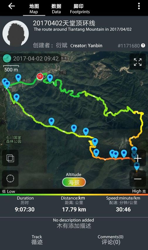
Shen, Ping                      Detecting Attractive Spots          54th ISOCARP Congress 2018
Liang, Jingyu                  Based on Geo-tagged Photos
Zhao, Miaoxi

a travel route recommendation system (Okuyama & Yanai, 2013). For managers, the
information contented in geo-tagged photos is used as a basis for planning tourism routes
and arranging tourism facilities (Yoshikawa, et al, 2010).
In addition, some scholars have tried to use GPS data of the track in tourism research. For
example, some studies used these data to research tourists’ behavior (Orellana, et al, 2012;
Meijles, et al, 2014; Donaire, et al, 2015). Base on the characteristics of tourists' behavior,
some scholars generated a tourist route selection model (Bierlaire & Frejinger, 2008) or
constructed a new tourism route design method (Li, et al, 2016).
It can be seen that research methods for outdoor hiking tourism are constantly evolving. At
present, tourism research based on geo-tagged photographs pays more attention to urban
built-up areas and less attention to the outskirts of the cities. These researches based on
GPS data of the track pay attention to the feature of the behavior of tourists and the
generation of routes, and basically have not advantages in identifying the features of spots
that attract tourists. This study focuses on the case of the northern outskirts of Guangzhou in
China and make comprehensive use of geographical information and visual information
carried by geo-tagged photos to obtain the attractive spots that hikers prefer to stay and to
identifies the features of the spots.

3. Research Foundation

3.1 Research Object
Hiking is a walking exercise which always occurs in the suburbs of cities or rural area. In
many countries, as leisure time increases, the proportion of people participating in hiking
tourism increases (Cole & Buckley, 2004). In China, hiking activities are mainly in short-
distance, and their destinations are always in the wild area or rural area (Jin, et al, 2012).
Areas that are easily accessible around large cities or densely populated areas often become
main destinations for short-distance travel (Bell, 2008).
The Zengcheng District and Conghua District in the northern part of Guangzhou have various
ecological and rural resources, attracting a large number of hikers. The “Master Plan of
Guangzhou (2011-2020)” introduces that the Liangkou Town, Lvtian Town and Wenquan
Town in Conghua District, Paitan Town, Xiaolou Town, and Zhengguo Town in Zengcheng
District have advantages in ecotourism. The elevation of this area ranges from 30 meters to
1170 meters and the slope range from 0 degrees to 50 degrees. Thanks to the great change
of topography, the ecological resources in this area are abundant. At the same time, this
area is in the northern part of Guangzhou and it is relatively convenient to get to. Therefore,
this area has been popular for hiking.
This study chose this area as a case, using the geo-tagged photos on the social networking
sites to identify the spots that attract hikers to stay and found tags representing the feature of
the spots.

                                                3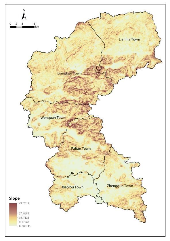
Shen, Ping                     Detecting Attractive Spots        54th ISOCARP Congress 2018
Liang, Jingyu                 Based on Geo-tagged Photos
Zhao, Miaoxi

     Figure 1: Topographic map of study area        Figure 2: Slope map of study area

3.2 Research Methods
With the development of outdoor travel activities and the popularization of GPS technology,
social networking sites for sharing geo-tagged photos have appeared on the Internet. These
social networking sites provide an opportunity to share photos with geographical coordinates
whenever and wherever users are doing outdoor activities. These sites provide hikers with
the opportunity to share GPS tracks and geo-tagged images online. They have been gaining
plenty of users in China.
After searching with “Conghua” and “Zengcheng” as keywords, this study used the software
called LocoySpider to gain geo-tagged images and corresponding GPS tracks on one
popular social networking site for hikers. A total of 19664 geo-tagged photos and 4116
corresponding GPS tracks were collected. After importing the original data into GIS for
visualization, the data outside the study area, the abnormal or non-hiking travel data were
filtered. Finally, 13157 corresponding geo-tagged photos and 2564 corresponding tracks
were obtained.
After importing these geo-tagged photos in GIS, we used density analysis to identify places
that attract people to stay and take photos. Based on the result of the density analysis, we
selected the 100 attractive spots with high density value. Then what people interested in
when they stay in these spots was explored. The content of the geo-tagged photos taken
within 50m around the attractive spots were studied. Based on the open sources database
on the Internet for image recognition, the content of these photos was recognized after
running a machine learning model. Then the top two representative tags were selected for
each attractive spot. These tags are able to tell us the types of the attractive spots and
contents of the majority of photos taken by hikers when they linger at the spot. What’s more,
the distribution rules of different types of spots were also summarized.

                                               4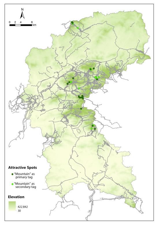
Shen, Ping                     Detecting Attractive Spots           54th ISOCARP Congress 2018
Liang, Jingyu                 Based on Geo-tagged Photos
Zhao, Miaoxi

            Figure 3: The GPS track and geo-tagged photos on one social networking site
               (The blue marks on the map represent the location of the shared photos)

4. Detecting the Attractive Spots of Hiking Tourism

4.1 Identifying the Attractive Spots
A small number of the tracks coincide with the existing county roads, while most of the routes
chosen by the hikers are just limited to walking. The hikers prefer the unhardened paths in
the wild which are always not recorded on the traditional maps. Many hikers find their ways
by tracking the GPS data shared by other hikers before. Thus, some routes have become
popular among the hikers through the spread of the Internet. The hiking tracks are unevenly
distributed across the study area. They are more intensive in the central area. The dense
area is in the southeast of Liangkou Town, followed by the north of Liangkou Town, the south
of Lvtian Town, the northwest of Wenquan Town and the north of Paitan Town.
Correspondingly, the 13157 geo-tagged photos were mainly distributed in the middle of the
study area, which match to the dense areas of GPS tracks. It can be seen that the
networking sites can provide a great deal of precise information on the behavior of hikers.

                                               5
Shen, Ping                      Detecting Attractive Spots             54th ISOCARP Congress 2018
Liang, Jingyu                  Based on Geo-tagged Photos
Zhao, Miaoxi

     Figure 4: The distribution of GPS tracks      Figure 5: The distribution of geo-tagged photos
If a place attracts many hikers to take photos, these places are supposed to have high-
quality landscapes or special events to attract hikers to stay (Arase, et al, 2010; Henderson,
et al, 2010). Based on the density analysis in GIS, 100 attractive spots with high-density
value were selected. These spots are mainly concentrated in the central-eastern part of the
study area, and a small number are located in the northern part of the area. They are
concentrated in the area where the topography changes greatly.

  Figure 6: The density of the geo-tagged photos       Figure 7: The 100 attractive spots selected

                                                   6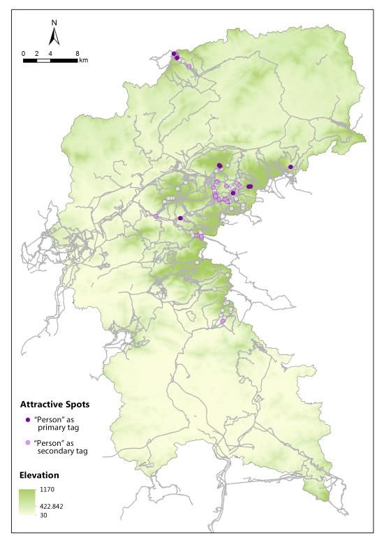
Shen, Ping Detecting Attractive Spots 54th ISOCARP Congress 2018
Liang, Jingyu Based on Geo-tagged Photos
Zhao, Miaoxi
4.2 Tags Generation of Attractive Spots
A total of 4403 geo-tagged photos taken within 50m around the attractive spots were
selected in this study. Based on the open database called ADE20K i for image recognition on
the Internet, the contents of these photos were recognized after running a machine learning
model.
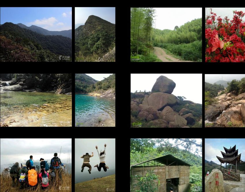
The most frequently occurring contents include “Mountain”, “Vegetation”, “Water”, “Rock”
“Building” and “Person”. For each photo, the proportions of “Mountain”, “Vegetation”, “Water”,
“Rock”, “Building” and “Person” were counted.
Figure 8: Some examples of photo identification
Figure 9: Photos with different main content
7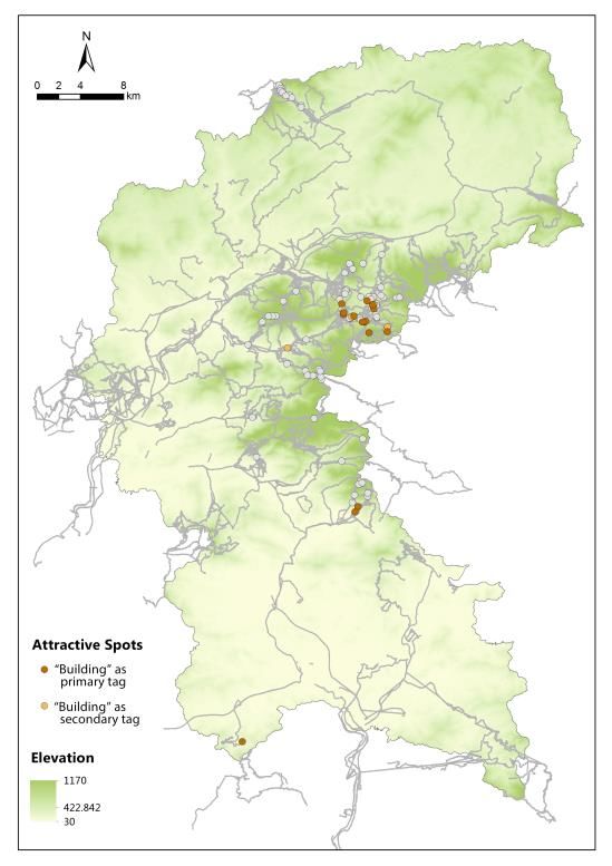
Shen, Ping                     Detecting Attractive Spots          54th ISOCARP Congress 2018
Liang, Jingyu                 Based on Geo-tagged Photos
Zhao, Miaoxi

For every photos, we calculated the relative proportion of each type of content in all photos to
achieve standardization. Since one spot usually has more than one attractive content, we
selected two representative tags including a primary tag and a secondary tag for each
attractive spot. The primary tag represents the first dominant content of the photos and the
secondary tag represents the second dominant content. These tags can tell us the types of
the attractive spots and contents of the majority of photos taken by hikers.

4.3 Distribution of Different Types of Attractive Spots
Different types of attractive spots have significant differences in attractive contents and
location distribution. For example, the attractive spots with the tags of "Mountain" are
generally places for enjoying the distant mountains with a good view; the attractive spots
tagged by "Vegetation" often have beautiful plants; the attractions of spots tagged by “Water”,
“Stone” and “Building” generally have close view of landscape; the attractive spots with the
"Person" tags are places where hikers usually stay for a longer period of time and take
portrait photos and they are usually the starting places or the resting stations of the routes.

    Figure 10: The spots tagged by “Mountain” Figure 11: The spots tagged by “Vegetation”

                                               8
Shen, Ping                     Detecting Attractive Spots         54th ISOCARP Congress 2018
Liang, Jingyu                 Based on Geo-tagged Photos
Zhao, Miaoxi

     Figure 12: The spots tagged by “Water”        Figure 13: The spots tagged by “Rock”

      Figure 14: The spots tagged by “Building” Figure 15: The spots tagged by “Person”
The elevation and slope information of each attractive spot were obtained to analyze the
distribution characteristics. It is seen that the attractive spots tagged by “Mountain” are the
highest in elevation and slope comparing with other categories. And they mostly occurred on
the top of the mountains or on the slopes. The spots tagged by “Vegetation” are widely
distributed in various elevation and slope. They are always in mountainous area which is
dense with vegetation. The spots with tags of "Water" have wide distribution of elevation but
most of them have gentle slope, indicating that the places with charming water view are

                                              9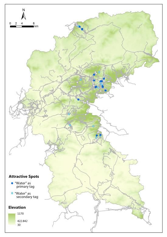
Shen, Ping                        Detecting Attractive Spots                  54th ISOCARP Congress 2018
Liang, Jingyu                    Based on Geo-tagged Photos
Zhao, Miaoxi

distributed at different elevations, but the water banks are slow in slope. The spots with tags
of "Stone" have low elevation distribution similar to the spots tagged by "Building", but the
slopes of these spots are higher. The attractive spots with the " Person " tags where hikers
take portrait photos as souvenirs are most widely distributed in elevation and slope. There is
not specific relationship between these spots and their topography. They are mainly choices
for resting places.

  Figure 17: Distribution of elevations of the spots        Figure 18: Distribution of slopes of the spots

5. Conclusion and Discussion

Hiking in the outskirts of mega cities as a kind of environmentally friendly and sustainable
urban tourism has significant benefits. For a long time, Internet has been the major
information media for hiking tourism, continuously expanding the market scale (Huang, 2005).
This study used geo-tagged photos on social networking sites to detect the attractive spots of
hiking tourism. It provides new ideas and directions for the study of hiking tourism. The
attractive spots obtained using this method can provide basis for the planning and
management of hiking tourism. For example, these spots can be places to provide travel
services after being fully equipped with service facilities. Besides, these places are where the
hikers prefer to stay, so they easily tend to be crowded. The security protection facilities and
the measures to prevent congestion should also be considered. The improvement of the
landscape quality of the spots based on their tags is also very important. For example, the
spots tagged by “Mountain” are generally places to enjoy the distant mountains, so they
should be ensured to have good visions. While the attractions of spots tagged by “Water”,
“Stone” and “Building” always have close views, the promotion of the original landscape and
the addition of new landscape structures can be taken into consideration.
The method used in this study has great potential in the planning and management of hiking
tourism, but there are still some limitations: 1) The chosen social networking site is mainly
targeted to groups loving hiking and reflects the information of many hikers, but it cannot fully
cover all the information of hikers. 2) If the satellite signals are not good enough in some
jungle districts, the geo-tagged information may be biased (Taczanowska, et al, 2008).
With the development of social networking sites and GPS technology, the information of geo-
tagged photos shared on the Internet will become more abundant, comprehensive and

                                                       10
Shen, Ping Detecting Attractive Spots 54th ISOCARP Congress 2018
Liang, Jingyu Based on Geo-tagged Photos
Zhao, Miaoxi
accurate. In actual planning and management, the attractive spots of hiking tourism obtained
by this method can provide effective early guidance. However, in the process of deepening
planning and management, this method needs to be combined with on-site investigation
because on-site investigation can verify the results obtained using this method and provide
corrections.
i Database source: http://groups.csail.mit.edu/vision/datasets/ADE20K/
Funding
This research is supported by the International Exchange Program for Graduate Students,
Tongji University (No.201801204)
References:
Arase, Y., Xie, X., Hara, T., & Nishio, S. (2010, October). Mining people's trips from large
scale geo-tagged photos. In Proceedings of the 18th ACM international conference on
Multimedia (pp. 133-142). ACM.
Beeco, J. A., Huang, W. J., Hallo, J. C., Norman, W. C., McGehee, N. G., McGee, J., &
Goetcheus, C. (2013). GPS tracking of travel routes of wanderers and planners. Tourism
Geographies, 15(3), 551-573.
Bell, S. (2008). Design for outdoor recreation. Taylor & Francis.
Bierlaire, M., & Frejinger, E. (2008). Route choice modeling with network-free data.
Transportation Research Part C: Emerging Technologies, 16(2), 187-198.
Cessford, G., & Muhar, A. (2003). Monitoring options for visitor numbers in national parks
and natural areas. Journal for nature conservation, 11(4), 240-250.
Cole, D. N. (2004). Impacts of hiking and camping on soils and vegetation: a review.
Environmental impacts of ecotourism, 41, 60.
Donaire, J. A., Galí, N., & Royo-Vela, M. (2015). Using GPS to analysis time-space tourists'
behaviour. A pre-test study in BoíValley. Cuadernos de Turismo, 35, 117-445.
Huang, X. (2005). Comparative study on international and domestic characteristics of hiking.
World Regional Studies, 14(3):72-79.
Jin, Q., Jia, S., & Li, T. (2012). The generation, development and prospect of hiking tourism
in China. In The 3rd Walking Forum Speech Collection (pp.11-16).
Kisilevich, S., Krstajic, M., Keim, D., Andrienko, N., & Andrienko, G. (2010, July). Event-
based analysis of people's activities and behavior using Flickr and Panoramio geotagged
photo collections. In Information visualisation (IV), 2010 14th international conference (pp.
289-296). IEEE.
Kurashima, T., Iwata, T., Irie, G., & Fujimura, K. (2013). Travel route recommendation using
geotagged photos. Knowledge and information systems, 37(1), 37-60.
Li, C., Wang, Y., Liu, Y., Dong, R., & Zhao, J. (2013). A Study of the Temporal-spatial
Behavior of Tourists Based on Georeferenced Photos. Tourism Tribune,28(10),30-36.
Li, Y., Ding, Y., & Wang D. (2016). A New Approach for Designing Tourist Routes by
Considering Travel Time Constraints and Spatial Behavior Characteristics of Tourists.
Tourism Tribune, 2016, 31(9):50-60.
11Shen, Ping Detecting Attractive Spots 54th ISOCARP Congress 2018
Liang, Jingyu Based on Geo-tagged Photos
Zhao, Miaoxi
Meijles, E. W., De Bakker, M., Groote, P. D., & Barske, R. (2014). Analysing hiker movement
patterns using GPS data: Implications for park management. Computers, Environment and
Urban Systems, 47, 44-57.
Murakami, E., & Wagner, D. P. (1999). Can using global positioning system (GPS) improve
trip reporting?.Transportation research part c: emerging technologies, 7(2-3), 149-165.
Nielsen, N., Harder, H., Tradisauskas, N., & Blichfeldt, B. S. (2010). Approaches to GPS-
survey of tourist movements within a North Sea island destination. E-Review of Tourism
Reseach.
Okuyama, K., & Yanai, K. (2013). A travel planning system based on travel trajectories
extracted from a large number of geotagged photos on the web. In The era of interactive
media(pp. 657-670). Springer, New York, NY.
Orellana, D., Bregt, A. K., Ligtenberg, A., & Wachowicz, M. (2012). Exploring visitor
movement patterns in natural recreational areas. Tourism Management, 33(3), 672-682.
Orsi, F., & Geneletti, D. (2013). Using geotagged photographs and GIS analysis to estimate
visitor flows in natural areas.Journal for Nature Conservation, 21(5), 359-368.
Papadopoulos, S., Zigkolis, C., Kompatsiaris, Y., & Vakali, A. (2011). Cluster-based
landmark and event detection for tagged photo collections. IEEE MultiMedia, 18(1), 52-63.
Sørensen, F., & Sundbo, J. (2014). Potentials for user-based innovation in tourism: the
example of GPS tracking of attraction visitors (pp. 132-153). Edward Elgar Publishing.
Taczanowska, K., Arnberger, A., & Muhar, A. (2006). Exploring spatial behaviour of visitors
in peri-urban recreational areas: multi-attribute analysis of individual route profiles. Paper
presentato in occasione del convegno: CORP 2006: 11th International Conference on Urban
Planning & Regional Development in the Information Society, Vienna, Austria, 13-16 febbraio,
2006. Atti del Convegno.
Taczanowska, K., González, L. M., Garcia-Massó, X., Muhar, A., Brandenburg, C., & Toca-
Herrera, J. L. (2014). Evaluating the structure and use of hiking trails in recreational areas
using a mixed GPS tracking and graph theory approach.Applied Geography, 55, 184-192.
Taczanowska, K., Muhar, A., & Brandenburg, C. (2008, October). Potential and limitations of
GPS tracking for monitoring spatial and temporal aspects of visitor behaviour in recreational
areas. In Fourth international conference on monitoring and management of visitor flows in
recreational and protected areas (pp. 451-455).
Yoshikawa, Y., Fukuda, T., & Yabuki, N. (2010). Development and Social Experiment for a
Tourism Information Collection System by Tourists.
12You can also read