Presentation African Diamond AB - BAKERVILLE 2015
←
→
Page content transcription
If your browser does not render page correctly, please read the page content below
Presentation
African Diamond AB
     BAKERVILLE
        2015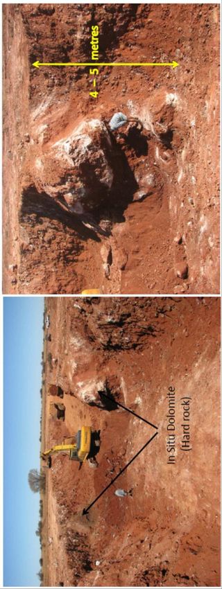
Summary of the Bakerville Project

The Bakerville Project Area is located approximately 20 km north of Lichtenburg in the Northwest Province of South Africa.
The area comprises portions of five farms namely, Zamekomst 4IP, Houthaaldoorns 2IP, and certain portions of
Welverdiend 361JP, Ruigtelaagte 353JP and Uitgevonden 355JP which covers a total area of 9275ha. The license boundaries
have been surveyed by a professional surveyor as required by the Department of Minerals and Energy (DME).

The area has good potential as historical mining on Welverdiend 361JP, Ruigtelaagte 353JP and Uitgevonden 355JP has
yielded in the order of 4 000 000 carats. The mineral rights on the farms Zamekomst 4IP, Houthaaldoorns 2IP were held by
De Beers since 1927, limiting increase in diamond production that could impact on the diamond price. The rights on these
farms only became available in 2003 when the mineral rights returned to the Government.

The area on Zamekomst 4IP prospected to date yielded diamonds of very good quality and the stones recovered to date
were up to 20 carats. The price per carat obtained in 2009 varied from US$ 238 (per carat) to US$ 1 448 (per carat).
•   Four potholes were delineated with diamond potential similar to historical potholes which yielded
    up to 200 000 or more carats

•   2030.77 carats recovered from Bulk Sampling in 2008/2009
    Sold for 366.25 US$/carat average
    Best priced parcel 1 448.06 US$/carat

•   Expanding resource base further through exploration

•   Potential for finding larger, high value stones

•   4688 ha gravel investigated on Zamekomst 4IP and Houthaaldoorns 2IP.

•   High price diamonds (up to 20 carat stone recovered, USD 1500 per parcel)

•   Gravel were processed through a 20tph DMS plant with a grease table and Flowsort final recovery

•   Resource 454 771 carats diamonds (inferred and additional) at +USD 366 /ct

•   Bulk sampling carried out by Pangea Diamonds

•   Test mining completed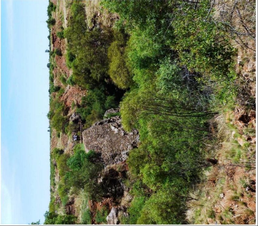
LOCALITY
The Bakerville Project is located within the Lichtenburg Diamond Fields, approximately 20km north of
Lichtenburg and 250km west of Johannesburg, it covers an area of 9275ha. The properties is accessible
travelling on the tar road from Lichtenburg to Zeerust and access the farm road on the right, just about
one kilometer before the Bakerville turn-off.

INFRASTRUCTURE
The Eskom grid is well developed throughout the project area and sidelines from the main grid supply
all farms.

Water is abundant in the area from drill holes and a Water Use License was obtained from the
Department of Water Affairs in July 2010.
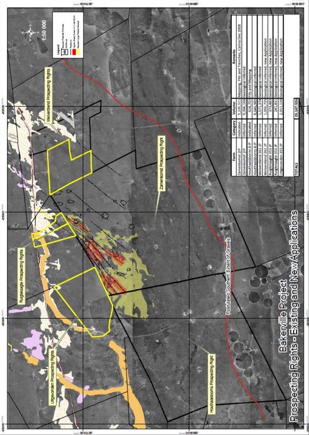
SUMMARY
The total project prospected incorporates 4688 ha of ground and the potential gravel
development area (Fig below) drilled and postulated gravel tonnages and volumes are set out in
the table below:

TABLE OF GRAVEL TONNAGES AND VOLUMES
LEGAL STATUS
The Bakerville Project Area is in total 9275ha, of which 8564ha is mining rights (Zamekomst,
Houthaaldoorns and Welverdiendand) and 711ha is prospecting rights (Ruigtelaagte and Uitgevonden).

Some drilling and/or test mining has been done on each of these rights to protect their legal status.
                               PROJECT            PROSPECTING RIGHT EXPIERY                                       ACTION TAKEN
                                                                   DATE

 Zamenkomst 4IP                                                 January 2021   Mining Rights renewable to 20131

 Houthaaldoorns 2IP                                             January 2021   Mining Rights renewable to 2031

 Welverdiend 361JP                                              January 2021   Mining Rights renewable to 2031

 Ruigtelaagte 353JP                                             18 June 2018   Prospecting Rights

 Uitgevonden 355JP                                              18 June2018    Prospecting Right

 Further applications could be lodged in future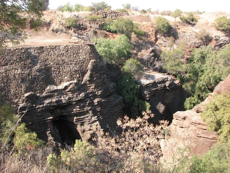
EXPLORATION MODEL
A record of the production from 1926 to 1989 for the Lichtenburg Diamondfields area is listed in the Table
below. Production reached a peak in 1931, and gradually tailed off after that. In the late 1970s, approximately
30 small-scale diggers were recovering about 650cts per year.
It is estimated that the Bakerville diggings produced more than 7.5Mcts of diamonds, the bulk of which are
reputed to have been derived from nine potholes with grades ranging from 2.5 to 250ct/100m3. The average
grade for the Lichtenburg fields was estimated by Du Toit (1951) to vary between 16ct/100m3 and
25ct/100m3. The remainder came from stretches along the numerous runs at an average grade ranging from
8ct/100m3 to 12ct/100m3. Individual potholes contained between 200,000cts and 1,000,000cts. The most
famous of these structures were the Bakerville Run and Malan’s, Welverdiend and Pienaar’s Potholes (Figure
below), all located immediately north of the Zamekomst Project Area.
In the early 1980’s, interest in the area was renewed with the release of a government survey report which
indicated that undiscovered diamondiferous gravels may occur beneath sand cover within sinkholes and
channels outside of the known major runs. This period saw the arrival of foreign and local mining and
exploration companies in the area.
With the introduction of geophysical prospecting techniques during the 1980’s, it became possible to probe
karst dolomitic areas blanketed by superficial cover. Solution cavities hidden beneath younger overburden
were detected through the application of gravity techniques.
However, gravity anomalies and the presence of cavities in the dolomite, whilst being indicative of
potential gravel traps, do not necessarily imply an accumulation of diamond-bearing alluvium.
Under the previous South African mineral laws, the mineral rights over many of the prospective properties
in the area were held by the large mining houses, indefinitely neutralising them from exploration by
outside parties. The new law Mineral and Petroleum Resource Development Act No. 28 of 2002 (MPRDA)
has unlocked previously neutralised property, providing opportunities for new entrants, such as Innovage.
                                    Farmname        TCts Produced

                   Grasfontein                                              2,466,344

                   Uitgevonden                                              2,022,884

                   Welverdiend                                              1,577,957

                   Ruigtelaagte                                              539,247

                   Klipkuil                                                  299,307

                   Manana                                                    138,067

                   Witklip                                                   139,891

                   Elizabeth                                                 111,944

                   Vlakplaats                                                 74,130

                   Hendriksdal                                                68,881

                   La Rey's Stryd                                             66,864

                   Pypklip                                                    19,887

                   Honingklip                                                  9,406

                   Trekdrift                                                   2,775

                   Graslaagte                                                  1,450

                   Doornplaat                                                     71

                   Houthaaldoorns                                                  6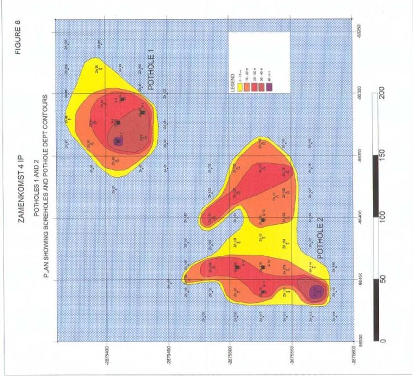
When the production figures shown in the table is plotted on the farms Grasfontein, Uigevonden,
Ruigtelaagte and Welverdiend then it is clear that a gap in production exist in the area Ruigtelaagte and
Zamekomst as shown in the map below.
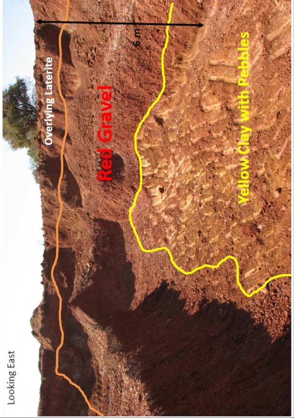
REGIONAL GEOLOGICAL SETTING
The regional geology of the project is comprised of the Transvaal Basin which is characterised by a
major unconformity that separates the underlying dolomite and iron formation sequence
(Chuniespoort Group) and the overlying Pretoria Group sediments. The unconformity is
characterised by a predominant chert breccia and chert-dominated conglomerates on a palaeo-
karst surface. The alluvial deposits of the Lichtenburg area overlie the irregular bedrock of Transvaal
Dolomite, (Lyttleton and Monte Christo Formations) which comprises dolomite inter-bedded with
chert units.
The Bakerville Project Area occurs within close proximity of the Welverdiend – Ruigtelaagte
Grasfontein run near Lichtenburg. The gravels occur as runs, representing an ancient braided
drainage system running east to west and covering an extensive floodplain. The runs now form a
positive topographic expression. This is due to the hard gravels protecting the underlying strata
from being eroded whilst the rest of the floodplain is denuded.
Large dolomitic palaeo-karst sinkholes or potholes of often present either within of outside of the runs. These
potholes are formed by dissolution in areas of increased groundwater flow, usually in areas of structural
weaknesses or faulting. The potholes were either formed during or post the run deposition and contain
gravels. The gravel within the potholes exhibits steep dips, and even overturning in places, indicating that
solution subsidence was active both during and after deposition of the gravel. The pothole fill is normally a
complex mixture of its own alluvial fill, together with collapsed material from the adjacent deposits. The
diamond grades recorded in the potholes are therefore dependent not only on the morphology of the
pothole, but also to a great extent on where it is situated relative to the run.
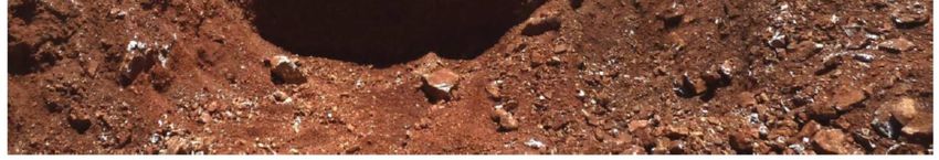
Photo shows King’s Pothole dissolution of the dolomitesEXPLORATION ACTIVITIES The objective of PDF’s exploration programme during 2005 – 2009 was to define diamond resources within the runs and associated potholes within the property area. Exploration commenced in 2005 with the first phase of reconnaissance exploration involving the use of satellite imagery, high resolution airborne magnetics, infrared surveys and ground gravity surveys. Thereafter, drilling was carried out to define the lateral and vertical extent of the gravels. Grade estimates were made using large diameter drill (LDD) holes and surface pitting. The samples were processed through a mobile dense medium separation (DMS) plant. During 2008 and 2009 larger (bulk) samples were treated from various localities across the extent of especially Portion 1 of the farm Zamenkomst 4IP. A smaller number of samples were also taken on the adjacent farm Houthaaldoorns 2IP. RECONNAISSANCE EXPLORATION Reconnaissance exploration commenced in 2005 and was conducted until the end of 2006. Airborne magnetics was used to identify structures, including dykes and lineaments. The ground gravity survey was completed on Portion 1 of Zamenkomst 4IP and was conducted on a 30m x 30m grid (Figure 5). The data obtained from this survey was combined with data obtained from a MSc. completed by Edgar Stetler (1980’s). The gravity survey was used to identify possible gravels in the form of both runs and potholes in areas of low gravity. Analyses of the results of these surveys, and the regional geological synthesis that followed, resulted in the identification of target areas and their extents. This was then followed up with drilling.
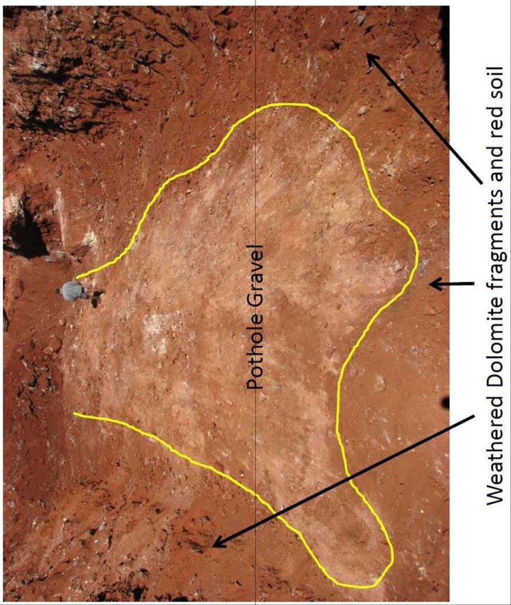
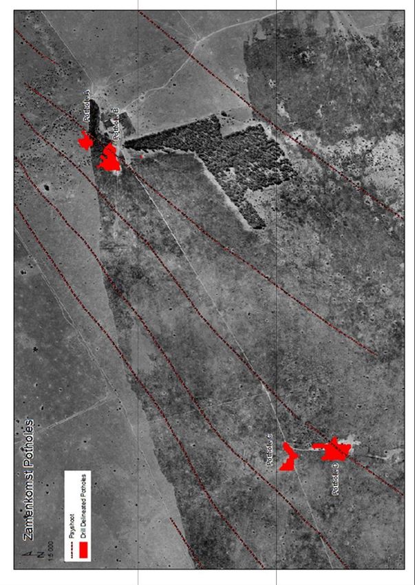
LOCAL AND DETAILED GEOLOGY
The gravels found in runs and potholes were deposited in three stages in the karst channels, resulting in a
stratigraphic package of breccia, channel run gravel and sheet (Rooikoppie) gravel. The gravels are
characterised by well-rounded clasts and are generally diamond-bearing. An overall thickening of these
gravels packages from east to west has been observed. These gravels are described in Table below.
There are at least four potholes present within the project area, which have been identified through reverse
circulation (RC) drilling (Figure below). The potholes range up to 40m in depth. Two additional potholes have
been located during the bulk sampling phase of the exploration activities. A characteristic of the Lichtenburg
diamond fields is the wide variation in diamond quality over short distances. Each deposit has its own
specific diamond suite and associated diamond sales value. This variation in shape, size and composition of
the diamond-bearing gravel bodies is a factor that has had an important bearing on their economic
potential.
The Figure 8 below shows the locality of the boreholes and the depth contours of Potholes 1 and 2 on
Zamekomst. Figure 12 shows a west-east section through Potholes 2. The gravel filling these potholes
consist of a thick upper and lower gravel zones separated by clays, diamictites and sand. At Zamekomst
chert, manganese and agates predominate with minor quartzite and quartz.
WORK COMPLETED
1. Bauer Large Diametre Drilling
   Eighteen Bauer LDD boreholes (Photo below) were drilled on Zamekomst to depths varying between 8 and
   41m. Some boreholes did not intersect the gravels in the potholes all the way to the bottom by the Bauer
   drilling as a result of obstructions, or caving of unconsolidated gravel and sand due to inflow of water.
   However, the drilling yielded diamonds after processing the material through the DMS and flow sorter. A
   total of 12 LDD holes (Bauer drill see photo) were drilled and a total of 53 diamonds was recovered, with
   an average stone size of 0.46 cts. The largest stone recovered was 2.65 cts.

2. Trench Bulk Sampling
   Surface samples were taken along east-west orientated trenches. These trenches are spaced
   approximately 200 m apart covering most of the northern extent of Portion 1 of the farm Zamenkomst 4IP.
   Individual samples were taken along these trenches. They were excavated using a loader with a bucket
   size of 5t to remove the upper 0.5m of the surface gravel. The sample pit dimensions are generally 100 m
   x 10 m and between 0.3 m and 0.5 m deep. Approximately 350 m3 to 500 m3 material was removed from
   each sample. All surface sample excavations were surveyed using a differential GPS by the on-site
   geologist.The samples were numbered sequentially beginning with the number (T1 … T14) where the
   prefix T, represents the trench number. The samples were stockpiled at the plant, and labelled in a similar
   manner to the LDD holes. A total of 264 samples have been excavated and treated to date.
3. Percussion and Reverse Circulation Drilling
  The RC drilling was conducted on a 100m grid to intersect gravel which had been previously identified
  in the gravity survey and from outcrop. Drilling was infilled on a 20m grid in order to delineate the
  extent of the gravel runs and potholes.
  Drill cuttings from the RC drilling are returned to surface inside the rods. Reverse circulation is achieved
  by blowing air down the rods which creates a differential pressure in the rod. The differential pressure
  creates air lift within the rod, causing the water and cuttings to move up and out the inner tube of the
  rod. The samples are collected in a sample bag.
  Drill diameter of 12.5cm to 20.0cm were used at Zamekomst. The penetration rate is dependent on the
  type of material, whether consolidated or unconsolidated material, where 1m/5min was achieved at
  Zamekomst. The maximum drill depth was dependant on the footwall and range from 7m to 45m. The
  number of holes drilled in a day ranged from five to seven holes a day.
  The samples were numbered sequentially from 1, with an alphabetical prefix Z which indicates the farm
  Zamenkomst, e.g. Z1.
  All holes were surveyed using a handheld GPS.
  Samples were taken at 1m intervals and placed in chip trays. The 1m samples were labelled according to
  the borehole number and depth of the sample, written with a permanent marker on the plastic top of the
  chip tray. The samples were logged by hand on site by the geologist on logsheets and later digitally
  captured.
4. Trail Mining
At least four potholes were delineated in the Bakerville Project Area during the RC drilling programme. The
RC drilling and delineated potholes are illustrated in Figure 7. The upper gravels were found to occur on
surface; therefore no overburden was present.
The thicknesses were modelled by gridding the data using an inverse distance squared method of
estimation. No search radius was used for the data; therefore, all data points were used in order to obtain a
more accurate thickness value for the Bakerville Project Area. The grid line geometry used was 200 by 200
grid lines. The limits of the modelling were chosen using the delineated gravel areas.
Modelling was completed on both runs and the four potholes separately.
The gravel thickness of the sheet gravels show that the gravel thickness generally increases from south to
the north, with the thickest regions in the northeast. There is no overburden for these gravels, which make it
a good target for mining. The potholes show thicker development of gravels, with the majority of the gravels
ranging between 8m and 4.5m.
The table below gives the estimated gravel tonnages and values for the lower and upper gravels at
Zamekomst Potholes 1 and 2 after projections and adjustments have been made to find some sensible
answers in the grease table values. It is emphasized that these are not actual values but merely based on
the results from the flow sorter.
TOTAL 202825 331600 596880 7.467 44570.3
CONCLUSION AND RECOMMENDATIONS

In the Bakerville Project two gravel types have been the focus of PDF’s exploration, namely the surface
gravels and the potholes. The two gravel types were identified using reconnaissance mapping and
geophysical survey. These were confirmed by RC drilling, trenching and pits. Whilst the surface gravels are
being mined, potholes are being identified on the property on an on-going basis and each one will be
evaluated as they are located. It is expected that the potholes will generally have higher grades than the
surface gravels.
The combined surface area of the current mining application is 9275ha which contains both surface
gravels similar to the historical mined ‘rooikoppie” deposits and deposits in buried channels and potholes
similar to those mined at Malan’s, King’s, Couper’s and Pienaar’s potholes. The total surface gravel volume
is approximately 29 million m3 at an average diluted grade of 2.5 carats per 100m3. Other deeper gravels
have currently been estimated to have a minimum potential of an additional 368 000m3 with further
volumes expected to be added to this quantity. The current volume will be sufficient for a life of mine of
26 years at 94 000m3 per month, and could produce 734 000 carats. Further exploration as part of the
mining process could add significantly to this.

DR M Levin
Consulting Geologist
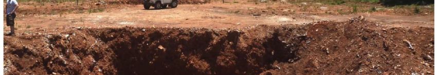
This little hole dug at Mariuss Sloot was less than 300m3 from which 30ct diamonds (@ US$500/ct) were
recovered giving a grade of 10ct/100m3.
Note the very flat land surface on the previous photograph. This land surface is up to 90 million years
old, older than the Alps and is part of the reason why diamonds were preserved here.

Shown below is Mariuss Sloot (Pothole) which was excavated by Pangea to give 10 to 11ct/100m3. This
pothole will be excavated further and generally these potholes have better grades as you go deeper. The
potholes are around 35 to 40m deep where the best grades are found. We expect this one to be a long
narrow structure when excavated is completed. Note the side wall dolomite (grey rock boulder on either
side) constricting the size of the pothole, but it all bodes well for high grade at depth.

We hope the Mariuss Pothole will develop into a large pothole such as the old King’s Pothole , shown
below, which delivered more than 1 million carats.
Disclaimer

African Diamond AB (“Adiam”), has taken all reasonable care in producing and publishing
information contained in this prospectus. Material in this prospectus may still contain
inaccuracies, omissions, or typographical errors, for which Adiam assumes no responsibility.
Adiam does not warrant or make any representations regarding the use, validity, accuracy,
completeness or reliability of any claims, statements or information in this prospectus.
Under no circumstances, including, but not limited to, negligence, shall Adiam be liable for
any direct, indirect, special, incidental, consequential, or other damages, including but not
limited to, loss of profits, whether or not advised of the possibility of damage, arising from
your use, or inability to use, the material in this prospectus. The information is not a
substitute for independent professional advice before making any investment decisions.
Furthermore, you may not modify or reproduce in any form, electronic or otherwise, any
information in this prospectus, except for personal use unless you have obtained our
express permission.
You can also read