IOT WI-FI- BASED INDOOR POSITIONING SYSTEM USING SMARTPHONES - AUTHOR: SUYASH GUPTA - TALENTICA SOFTWARE
←
→
Page content transcription
If your browser does not render page correctly, please read the page content below
IoT
Wi-Fi- based Indoor Positioning
 System Using Smartphones
          Author: Suyash Gupta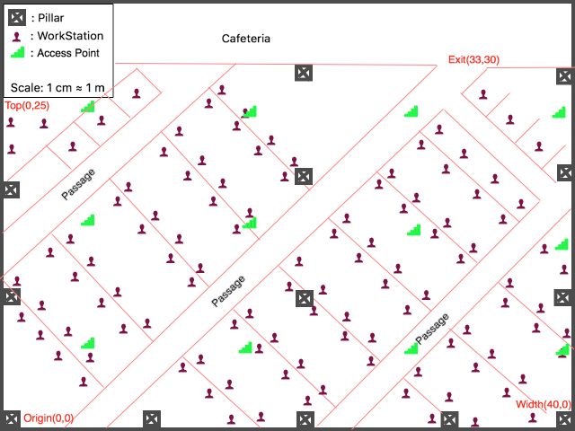
Abstract
                                         The demand for Indoor Location Based Services
                                         (LBS) is increasing over the past years as
                                         smartphone market expands. There's a growing
                                         interest in developing efficient and reliable
                                         indoor positioning systems for mobile devices.
                                         Smartphone users can get their fixed locations
                                         according to the function of the GPS receiver.
                                         This is the primary reason why there is a huge
                                         demand for real-time location information of
                                         mobile users. However, the GPS receiver is
                                         often not effective in indoor environments due
                                         to signal attenuation, even as the major
                                         positioning devices have a powerful accuracy
                                         for outdoor positioning.

                                         Using Wi-Fi signal strength for
                                         fingerprint-based approaches attract more and
                                         more attention due to the wide deployment of
                                         Wi-Fi access points or routers. Indoor
                                         positioning problem using Wi-Fi signal
                                         fingerprints can be viewed as a
                                         machine-learning task to be solved
                                         mathematically. This whitepaper proposes an
                                         efficient and reliable Wi-Fi real-time indoor
                                         positioning system using fingerprinting
                                         algorithm. The proposed positioning system
                                         comprises of an Android App equipped with
                                         the same algorithms, which is tested and
                                         evaluated in multiple indoor scenarios.
                                         Simulation and testing results show that the
                                         proposed system is a feasible LBS solution.

© Talentica Software (I) Pvt Ltd. 2018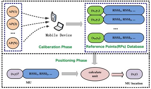
Contents
1. Introduction                                         3

2. Indoor Positioning Systems                           4
  2.1 Indoor Positioning Techniques                     5
      2.1.1 Trilateration method                        7
      2.1.2 Fingerprinting method                       7

3. Exploring Fingerprinting method                      8
  3.1 Calibration Phase                                 8
  3.2 Positioning Phase                                 11
       3.2.1 Deterministic algorithm                    12
       3.2.2 Probabilistic algorithm                    13
  3.3 Fingerprint Positioning Vs. Trilateration         13
  3.4 Technical Challenges in Wi-Fi based positioning   14

4. Design of Experiment and results                     15
  4.1 Design Details                                    15
  4.2 Tests Results                                     17

5. Conclusion and Future Work                           21

6. References                                           21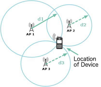
Introduction
                                         With the rapid development of mobile communication
                                         and the pervasive computing technology, the
                                         requirement of obtaining location-aware services is
                                         rapidly increasing. Dramatic performance improvements
                                         in mobile communications standards have propelled
                                         mobile technology to become the fastest adopted
                                         technology of all times. Mobile network infrastructure
                                         costs have also fallen dramatically, while performance
                                         has soared.

                                         Over the past decade, we have seen great
                                         improvements in downsizing of the computer hardware,
                                         arrival of various new technologies like wireless
                                         networks, battery capacities, high performance chips
                                         etc, which made mobile devices a smartphone. These
                                         technologies allowed the manufacturers to build mobile
                                         devices that can be carried around and have the same
                                         performance as traditional computers. The benefit of
                                         mobile devices can be leveraged by the so-called
                                         location-based services. Applications that act differently
                                         depending on the location or the context of the user or,
                                         even better, proactively offer location dependent
                                         information to the user are currently a hot topic in
                                         research and are considered a promising market.

                                         Nowadays, the Global Positioning System (GPS) can
                                         provide accurate and reliable position information for
                                         location services. GPS cannot be used effectively under
                                         indoor environment since there is a signal degradation.
                                         Thus various positioning-enabled sensors such as GPS
                                         receivers, accelerometers, gyroscopes, digital
                                         compasses, cameras, Wi-Fi etc. have been built in
                                         smartphones for communication, entertainment and
                                         location-based services.

                                         In this whitepaper, we will discuss about an indoor
                                         positioning system made using the Wi-Fi routers which
                                         are called Access Points (APs) and a Wi-Fi enabled
                                         android smartphone. But before moving further, what
                                         all technologies are available for indoor positioning?
                                         And why are we using Wi-Fi?

© Talentica Software (I) Pvt Ltd. 2018                                                           3
Indoor Positioning Systems
Indoor localization systems employ a wide range The use of Wi-Fi to estimate
of different technologies; these systems could
location is a great approach, since
use any combination of the following:
Wi-Fi Access Points (AP) are readily
• Ultra-wideband (UWB) available in large quantities in
• Infrared today's indoor environment and it is
• Radio frequency identification (RFID)
possible to use available mobile
• Inertial sensors, magnetic sensors etc.
• Sound (ultra-sound or audible sound)
devices on the users' side.
• Wi-Fi
This process of estimation involves capturing the
• Camera
strength of Wi-Fi signal received on the device’s
end and then using it to do analysis regarding
The first five positioning systems in the above
the user’s location. Let’s explore the different
listing are able to localize users with high
techniques using which we can determine the
accuracies. However, these systems require the
location of a user.
installation of additional hardware, which lead to
high budget and labor cost, preventing them
from having large-scale deployments.
© Talentica Software (I) Pvt Ltd. 2018 4Indoor Positioning Techniques
In Table 1 below, the accuracy, key characteristics, Wi-Fi positioning and INS can provide medium
main advantages and disadvantages of the accuracy without LoS, thus they are more
various positioning techniques used in mobile suitable to be used in indoor environments.
devices are compared. GPS with a high accuracy However, high cost for infrastructure and limited
has emerged as the leading technique to provide coverage is a major issue for Wi-Fi positioning.
location information. Assisted GPS (A-GPS) is a INS also has some issues since it is prone to
system allowing global positioning system (GPS) rapid accumulative errors.
receivers to obtain information from network
resources to assist in satellite location. An A-GPS
system is especially useful when the receiver is in
a location where it is difficult for the satellite
signals to penetrate. Both GPS and A-GPS
techniques need the signal from the satellite to
propagate without obstruction to the receiver,
which is the line of sight (LoS), to support high
accuracy positioning.
Table-1: Comparison of Indoor Positioning techniques based on their accuracy level, advantages
and disadvantages.
Technique Accuracy Level Advantage/ Disadvantage
GPS High (Let’s explore more about Wi-Fi positioning • Radio Signature: For a given location the signal
techniques. There are few terms we need to strengths from all the APs create a unique set of
understand before moving forward. information which can also be referred to as the
radio signature for that location.
• Access Points (APs):
It is a networking device that allows a Wi-Fi The two most frequently used methods for
enabled device to connect to a wired network. estimating the location of indoor mobile objects
For e.g, Wi-Fi routers. with Wi-Fi networks are:
• Received Signal Strength (RSS):
It is a measurement of how well your device can
hear a signal from an access point or router. It is
a value that is useful to determine if you have
enough signal to get a good wireless connection.
Note: Because a RSS value is pulled from the
mobile device’s Wi-Fi card (hence “received”
signal strength), it is not the same as transmit
power from a router or AP.
• Wireless local area network (WLAN):
It is a wireless computer network that links two or
more devices using wireless communication
within a limited area such as a home, school,
computer laboratory, or office building.
802. IEEE 802.11 standards: It refers to the set
of standards that define communication for
wireless LANs (wireless local area networks, or
WLANs). The technology behind 802.11 is
branded to consumers as Wi-Fi. IEEE 802.11 is the
set of technical guidelines for implementing
Wi-Fi.
© Talentica Software (I) Pvt Ltd. 2018 6Trilateration method: Since the complexity of indoor space can have a
This method is widely used in conventional great impact on the signal, when one converts
surveying and GPS positioning. It uses the the signal strength to a spatial distance, it can
distances of an object from three or more known inevitably produce errors. To reduce the error,
fixed points, to determine the position of an researchers have suggested a variety of methods
object. As shown in the below figure there are to assist trilateration. If you want to explore
three APs to send signals which is received by the more in this area of research, read here.
mobile device. Now the received signals (RSS
values) are converted into spatial distances, which Fingerprinting method:
are used as the radii of circles i.e. d1, d2, d3 etc.
This method has been used for indoor
positioning for several years. Its main advantage
Figure-1: Simple design of Trilateration method is that it can use existing WLAN infrastructures
for Indoor Positioning or other network environments. Compared to
techniques like Trilateration, Fingerprinting
technique is more suitable for indoor
environments and is relatively simple to deploy.
There are no specific hardware requirements, so
any existing WLAN infrastructure can be used
for positioning.
© Talentica Software (I) Pvt Ltd. 2018 7Exploring Fingerprinting method
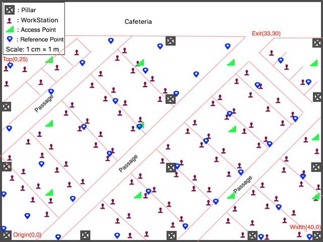
The fingerprinting method is based on the Step-1: We can draw the indoor area where the
relationship between a given location and its WLAN system is setup on any type of canvaslike
corresponding radio signature. Drawing sheet, Paint Software etc. or we can go
for any other software available online for this
It’s been observed that points with purpose. We should consider taking a scale
before drawing which is equivalent to the
a certain minimum distance
real-time reading in the area.I have taken one
between them and spread over the cm on drawing sheet equivalent to one meter on
area of interest possess a unique the area of interest since it was suitable for me.
set of RSS readings from APs and Now after deciding the scale, measure the area’s
this is referred to as the fingerprint dimensions like width and height, convert it to
your scale and draw it on the canvas taking any
for that location. corner as origin (0,0). Next task would be to start
locating access points on the canvas based on
Let’s try to understand more about this method.
their position according to origin.
When used with Wi-Fi systems, the
fingerprinting method can be typically divided
Please refer the following figure for better
into two phases, calibration phase and
understanding; this is the layout of my
positioning phase.
organization where I conducted the experiment.
Calibration Phase:
As the name suggests, this is a phase in which
we calibrate the area of interest based on some
Reference points. To have a better
understanding of this phase lets go through the
process implemented to achieve the unknown
location of a device.
© Talentica Software (I) Pvt Ltd. 2018 8Figure-2: Floor plan showing location of APs
Step-2: Now we would select some points in the In case if a particular point is out of range of an
area of interest which are placed at a definite AP then we can assume the least possible value
interval and spread all over the area of interest of signal strength in that case, so that each RP
like a grid as show in the figure below and these will have a reading from all APs. Now looking at
points are called Reference points(RPs). Each the information available to us, we see that each
reference point will have signal strength RP has a unique set of signal strength readings
readings from APs in the area of interest. If a from the Aps. They also have a fixed location
particular RP is closer to a particular AP, then the which makes it a unique point in the area of
signal strength will be strong and vice-versa. interest which can be referenced as a fingerprint
for that location. So we are going to take
readings from multiple reference points, store
them in the local database.
© Talentica Software (I) Pvt Ltd. 2018 9Figure-3: Floor plan showing location of APs and RPs Step-3: Again, we are taking RSS readings on All this information is stored in the local each RP from all the APs assuming if AP is out of database in which RSS readings of all the RPs range, then we assign it the least value of RSS. which contains mean values from each AP and Now for a fact, I want to let you know that RSS AP details like location, IP etc are saved. To values fluctuate with time. So to fix this, I took make this database I have made an Android App multiple RSS values in a definite time interval which stores the details of AP and RP. Read here (for e.g.10 values in an interval of 2 seconds) and to explore it. took mean of them. Now let’s say there are 4 RPs, then each RP will have 4 mean RSS readings. Apart from mean RSS values, we also know the location coordinates of RP and AP. © Talentica Software (I) Pvt Ltd. 2018 10
Positioning Phase:
We now have ample amount of information              Now we already have a dedicated database of
about the area of interest. We know near which       points which are scattered all over the area
RP the signal strength of which AP is strongest      (RPs). We must pick the points which are nearest
and weakest and we know the locations of that        to the unknown location matching their signal
AP and RP. Let’s say we want to locate the device    strengths. This evaluation can be done using
which is at an unknown location. We first scan       Fingerprinting algorithms.
the area using Wi-Fi for the available APs on that
point and we calculate their mean signal strength
values.

                    Figure-4: Simple design to explain the Fingerprinting method

Fingerprinting algorithms can be classified into two basic groups: deterministic and probabilistic
algorithm.

© Talentica Software (I) Pvt Ltd. 2018                                                               11
Deterministic algorithm: So let’s say there are n number of RPs in an area,
As the name suggests, this algorithm attempts to then we get n number of Euclidean distance at
find the minimum distance between the unknown an unknown location and the least Euclidean
location and various calibration reference points distance will be the nearest neighbour.
location from database. This may or may not be
equal to the minimum physical distance between • K-Nearest-Neighbor (KNN) Algorithm:
the actual device’s location and the recorded The KNN algorithm is an extension of the NN
location of nearest RP from the calibration phase. algorithm introduced above. “K” is the number
The distance between the device’s actual location of the minimum Euclidean distance values. To
and evaluated location from algorithm is elaborate, in the NN algorithm we considered
generally regarded as the best raw location only one nearest neighbor and here we take into
estimate contained in the calibration database. account K number of nearest neighbors. If k=1
then KNN turns into NN. After getting K number
Different types of deterministic algorithm: of nearest neighbors we take mean of their
location co-ordinates and the outcome is the
• Nearest Neighbor (NN) Algorithm: estimated location of the device.
The nearest neighbour algorithm is easy to
implement and executes quickly. We know we • Weighted K-Nearest Neighbors Algorithm:
have stored RPs in database and each RP have This is again extension of KNN algorithm. The
RSS mean values from each AP. The idea of this difference here is instead of taking mean of
algorithm is to calculate the Euclidean distance location co-ordinates we perform weighted
between the RSS values from all APs at an mean.
unknown location and the signal strength mean
values of APs from each RP recorded in database,
and later find the closest neighbor. The Euclidean
distanceis defined as length of line segment
which is connecting two given points.
© Talentica Software (I) Pvt Ltd. 2018 12Probabilistic algorithm:
In order to achieve more accurate results, probabilistic algorithms have been developed. These
algorithms are also sometimes called randomized algorithms. A probabilistic algorithm is an
algorithm where the result and/or the way the result is obtained depend on chance. Here instead of
calculating the Euclidian distance we calculate the probability of the device’s location near to an RP
using a probability factor [c]. Please explore the android app which is made in this reference to have
a better understanding. Also you will be able know about implementation of these algorithms at
code level.
Fingerprint Positioning Vs. Trilateration:
Table-2: Comparison of Trilateration and Fingerprinting method
Method Accuracy Advantage Disadvantage
Continuous positioning; poor positioning accuracy
no calibration phase may occur, caused by
Trilateration Medium
required environmental effects
Continuous positioning; Poor positioning accuracy
environmental effects are in environment where
High considered in the surroundings change
Fingerprinting
calibration phase frequently
© Talentica Software (I) Pvt Ltd. 2018 13Technical Challenges in Wi-Fi • Furthermore, normal human body can also
affect the WLAN signal strength since the 2.4
based positioning: GHz Wi-Fi signal strength could be greatly
attenuated through human bodies, which
There are some technical challenges in
consists of 70% water and water can absorb the
designing and deploying signal strength based
resonance frequency at the 2.4 GHz. Therefore,
indoor positioning system using smartphones as
when signal strengths are collected using a
a platform. The instability of RSS in indoor
smartphone, the RSS values on the straight line
environments is the major challenge for
between the smartphone and an access point
RSS-based WLAN positioning systems.
(AP) will be influenced by the body of the
person. To overcome this, we can have time
• The first reason is the structure of the indoor
factor too in the experiment, which can change
environment and the presence of different
the mean values of RSS for an AP. In that case
obstacles, such as walls, doors and metal
we need to take readings in calibration phase
furniture etc.
at multiple times in a day.
The WLAN signals experience severe multipath
and fading effects. Also the RSS value varies
over time, even taken at the same location.
• Secondly, the IEEE 802.11 WLAN frequency
range is in the 2.4 GHz public bands, which is
shared with many other devices such as
microwave ovens, smartphones, laptops and
other wireless signal transmitters. In the
calibration phase, which is used for collecting
the RSS data and storing the corresponding
location information in a database, these
devices will likely lead to radio interference and
make the wireless signal strength fluctuate.
© Talentica Software (I) Pvt Ltd. 2018 14Design of Experiment and results
Design Details:
The space taken is of 30m x 40 m with scale as 1cm equivalent to 1m. The Wi-Fi routers are shown in
green color icons and RPs in blue color icons. We used Nexus 5X with Android 7.1.1 (Nougat) to
capture the RSS data. At each RP 10 readings of all APs are taken in an interval of 3 seconds and
their mean is stored as RSS values of APs from that RP.
Also, an Android App has been developed for this purpose and you can check out github here.
When using the App for the first time, the opening screen shows to add a project i.e. name the area
of interest where you want to conduct experiment. Once the project is created, you can start adding
all access points available in the area of interest. There is an interface specifically designed for it in
the App. It automatically scans the available APs in the area and then you add them one-by-one with
positions (x, y).
Figure-5: App showing project name and recorded APs and RPs in the area of interest
Selecting a project shows its APs and RPs with
App home screen showing list of projects
their locations (x,y)
© Talentica Software (I) Pvt Ltd. 2018 15Next you need to plan for reference point’s addition. Below is the figure of floor plan for 2m distance
interval between RPs.
Figure-6: Floor Plan with 2m distance between RPs (blue)
As we can see above, we used 2m as the distance interval between RPs above. We could have used
1m or 1.5m, right? So let me tell you I tried with all 3 intervals and the results were not satisfactory
for 1m and 1.5m interval.
© Talentica Software (I) Pvt Ltd. 2018 16Tests Results
The result of the three scenarios are mentioned All the location values are approximated to the
below in tables. The Actual location stands for the nearest integers. The acceptable column is
location on which we are testing the App and the judged by how much offset distance both the
location returned by the App is under location readings have. If it is greater than twice the
evaluated from the App in positioning phase. interval, then it’s not acceptable.
Table-3: Results for test scenario 1 (RP spacing: 2 m)
Test Point Actual Location(m) Location evaluated from App(m) Acceptable?
X Y X Y
1 06 14 05 15 Yes
2 06 20 05 22 Yes
3 06 30 05 29 Yes
4 13 14 10 14 Yes
5 13 26 11 24 Yes
6 22 02 23 04 Yes
7 22 22 23 24 Yes
8 31 14 33 19 Yes
9 34 02 35 03 Yes
10 35 16 35 18 Yes
Total matching Rate 90%
© Talentica Software (I) Pvt Ltd. 2018 17Table-4: Results for test scenario 2 (RP spacing: 1.5 m)
Test Point Actual Location(m) Location evaluated from App(m) Acceptable?
X Y X Y
1 06 14 05 14 Yes
2 06 20 05 23 No
3 06 30 04 26 No
4 13 14 10 17 No
5 13 26 12 25 Yes
6 22 02 24 05 No
7 22 22 22 24 Yes
8 31 14 33 19 No
9 34 02 35 03 Yes
10 35 16 34 17 Yes
Total matching Rate 50%
© Talentica Software (I) Pvt Ltd. 2018 18Table-5: Results for test scenario 3 (RP spacing: 1 m)
Test Point Actual Location(m) Location evaluated from App(m) Acceptable?
X Y X Y
1 06 14 08 05 No
2 06 20 07 13 No
3 06 30 08 26 No
4 13 14 10 17 No
5 13 26 12 28 No
6 22 02 14 05 No
7 22 22 14 24 No
8 31 14 34 19 No
9 34 02 34 01 Yes
10 35 16 39 22 No
Total matching Rate 10%
© Talentica Software (I) Pvt Ltd. 2018 19According to the results, scenario 1 has the best When a time series of RSS values are received by match rate of 90% while scenario 3 has the worst a mobile device at a fixed point under the match rate of 10%. Scenario 2 gives the total unchanged environmental settings, the smaller match rate of 50%. For scenario 3 results, the the variations in the RSSs, the more stable the reason for the failure rate of 10% is that the RSS observations. For the success rate of the RSS unknown point has similar distances to more observations, a mobile device may either fail to than one nearby RPs. In this case the matching provide stable RSS observations or receive out algorithm cannot successfully identify the real of range RSS values. This failure is most likely best matched one due to the limited grid caused by the poor quality of the Wi-Fi adapter. resolution. Comparing the results among the three scenarios, we can conclude that the spacing of the RPs setup for scenario 1 is reliable for our location determination in testing indoor environment since the success rate reaches 90% with an accuracy roughly equal to 2m spacing. The performance of a positioning system is mainly determined by both positioning algorithm and quality of observations. Different mobile devices receive different qualities of observations due to different performance of their Wi-Fi adapters. The quality of the observations can be measured by several factors including accuracy, stability and success rate etc. © Talentica Software (I) Pvt Ltd. 2018 20
Conclusion and Future Work
We discussed indoor Wi-Fi positioning                The fingerprinting process must be done for
technology; including the various phases and         each type of Wi-Fi adapter. Further experiment
process of Wi-Fi fingerprinting technology and       needs to be carried out to investigate new
we classified the methods used across the            methods to reduce the impact of the
phases. Tests show that applying
                            proper RP                device-dependent errors. High stability is
                                                     expected for other mobile devices rather than
interval for fingerprint-based
                                                     LG smartphone.
positioning can significantly improve
the positioning accuracy.                            • Multi-sensor fusion: most current smartphones
                                                     are equipped with other types of sensors such as
Several aspects can be further explored to           accelerometer, gyroscope and digital compass,
enhance the performance of the proposed Wi-Fi        in addition to the built-in Wi-Fi adapter. Data
based positioning system for future work. Two        obtained from these sensors could be very
main aspects are listed as follows:                  useful sources of information for indoor
                                                     positioning since it can provide auxiliary data
• Setup RSS database for different brand Wi-Fi       such as speed and orientation of movement. The
adapters: The proposed indoor positioning            improved positioning system can therefore
system is device-dependent, thus different brand     make best use of the observations from these
Wi-Fi adapters with various receiving capabilities   sensors to improve the accuracy of the position
need to be tested.                                   estimates. New algorithms for the integrated
                                                     system need to be developed and its
                                                     performance needs to be assessed.

References
• IEEE: https://www.techopedia.com/definition/24967/ieee-80211
• A Practical Path Loss Model For Indoor Wi-Fi Positioning Enhancement:
  http://personal.ee.surrey.ac.uk/Personal/C.Foh/pub/04449717-icics07.pdf
• Probabilistic Algorithm: https://en.wikipedia.org/wiki/Randomized_algorithm
• PARMANATHAN, V. 2006. Area Localization using WLAN. Master, The Royal Institute of Technology

© Talentica Software (I) Pvt Ltd. 2018                                                            21
You can also read