WELLFIELD MANAGEMENT SYSTEM (WFMS) FOR THE SALDANHA BAY AREA
←
→
Page content transcription
If your browser does not render page correctly, please read the page content below
Annex 1 - Terms of reference

Wellfield Management System (WfMS) for the Saldanha Bay area

Background
The Strategic Water Sector Cooperation (SSC) between Denmark and South Africa is a long-term bilateral
cooperation, which amongst others are contributing to the South African water sector by demonstrating
and testing different Danish groundwater mapping and assessment methodologies in South Africa in order
to add long-term value to the South African work on optimizing the utilization of groundwater.

Saldanha Bay Local Municipality (SBLM) is augmenting the bulk water supply from the Berg River systems
with three groundwater well fields (Langebaan Road, Langebaan Road extension and Hopefield). The three
wellfields are in the primary aquifer (Langebaan Road aquifer) and the last two are newly developed. The
surface water (rivers and dams) in the area is also supplying other cities in Western Cape, most notably
Cape Town. Adding new water sources to Saldanha Bay will therefore support water supply in the area as a
whole. The Koningsvlei area is one of two additional wellfields to be developed, with a possibility of a
seawater desalination plant and MAR scheme in the near future to be added into the water mix. See
Appendix 1 for further details of present activities.

The purpose of this project is to develop a wellfield management system (WfMS), that can secure water
supply for SBLM in a sustainable way (quantity and quality of the drinking water, protection of vulnerable
zones, no impact on groundwater dependent ecosystems, prepared for future water demands from
competing water users, such as Cape Town, at optimal economical effectiveness etc.).

Parallel to this, a regional geological model and a flow model of the area shall be made on basis of
approaches of the mentioned Danish groundwater mapping. The primary purpose of the models is to give
input data to the WfMS.

It should be noted, that in a later stage (phase C - not part of this project), it is planned to implement and
test the WfMS model. Based on the results of testing, the WfMS may be revised. It is also planned to
develop the geological model and flow model into local and well field models. See section on Timeline
below.

The project therefore consist of two parallel phases (phase A and B), described in detail below. In both
phases, there is a strong focus on capacity building:

Capacity building
After completion of the project, the system and the models shall be handed over to SBLM for further use
and management. Therefore, capacity building forms an essential part of the project. Concretely we talk at
capacitating between 5 and 10 people, expected to be managers and technicians from SBLM, West Coast
District Municipality and the South African Department of Water and Sanitation (DWS).

Deliverables
    -   Successful capacity building.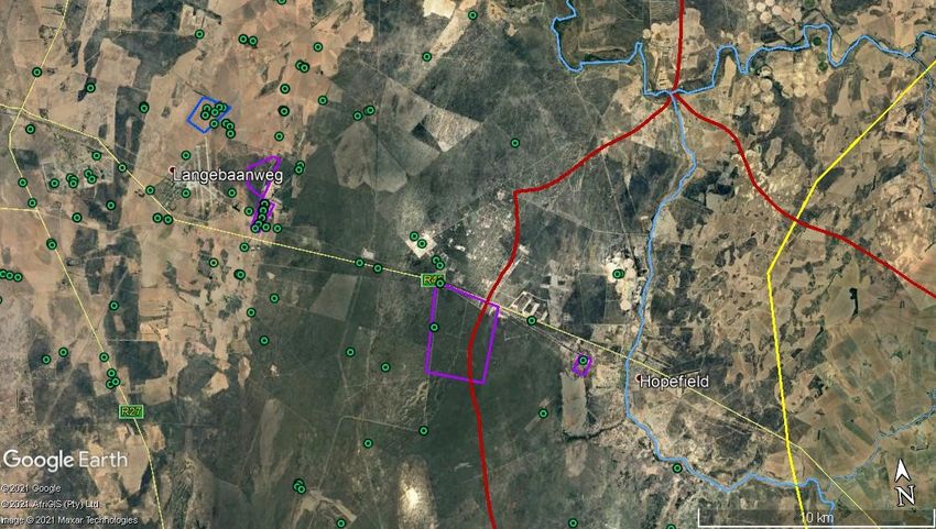
-   A documentation report (5-10 pages) of the capacity building process, which can be used to assist
        in similar processes in other South African municipalities.

Note with regard to the offer, that:
    1. The offer must include a proposal for the capacity building in practice. As an example, it can consist
       of a combination of on-the-ground and online training and knowledge exchange, and also using a
       combination of the different project consultants, so that e.g. consultants from outside South Africa
       is supported by eventual South African consultants.
    2. The proposal must account for a certain flexibility for changes, identified during the project period
       or due to the fact that any plans during the covid-19 pandemic might have to be changed.

Phase A – Development of a Wellfield Management System (WfMS)
A Wellfield Management System developed in cooperation with – and to meet the needs of – SBLM.

The SBLM has a wish for the system to be able to support day-to-day operations of the wellfields in
connection to other water sources, which is mainly river water at the moment. The system must also be
flexible and prepared for future expansions in water sources (e.g. MAR, desalination), supply infrastructure
and future identifications of management needs.

In addition, the system shall also be able to handle seasonal fluctuations and to provide input for long-term
sustainable water management, within the framework of the All Towns Reconciliation Strategies of the
area (see https://filkassen.statens-it.dk/u/sivr7Myr66WgK-vn/Saldanha%202021?l).

Further needs and purposes may be identified at the beginning of the project.

The system shall be based on current and known future supply demand patterns, infrastructure design
constraints and mapping of existing and potential water sources and their importance in the water mix.
Data from the wellfield monitoring shall feed into the system, together with day-to-day monitoring data of
the surface water and other sources. Data are typically provided in an excel format.

It is important to take into account that there is some freedom in the design of the system, as SBLM have
no other existing systems that the new system must interact with directly. Provision need to be made to
include future modules, e.g. on new wellfield, MAR and desalination.

Data from the system shall feed into regional and national databases.

Finally, it should be noted, that SBLM is in the process of assigning a consultant to do regular (monthly,
quarterly and biannual) groundwater level and quality monitoring and reporting on the wellfields,
groundwater flow mapping, delineation of protection zones and the identification of a new MAR area. This
consultant is expected to be in place in May and will cooperate with this project.

Deliverables
    -   A Wellfield Management System, including license and software support for a minimum of two
        years.
    -   A manual to manage the WfMS and to update it with new info, after completion of the project.
    -   A framework for capturing future data from the geological and flow models (phase B)
    -   A documentation report (5-10 pages) of the development process for use in similar development in
        other South African municipalities.
Note with regard to the offer, that:
1. Eventual programme licenses and system support fees for the first two years shall be part of the
offered fixed price.
2. The aim of the project is to develop a robust system at minimum maintenance costs and maximum
flexibility in use. Therefore, in the offer eventual license and support costs after the first two years
and constraints on having other consultants using and developing the system after the end of the
project period shall be described, as this will form part of the evaluation of the offer.
Phase B – Geological model and flow model
Phase B consists of two sequential and overlapping activities: A geological model and a flow model.
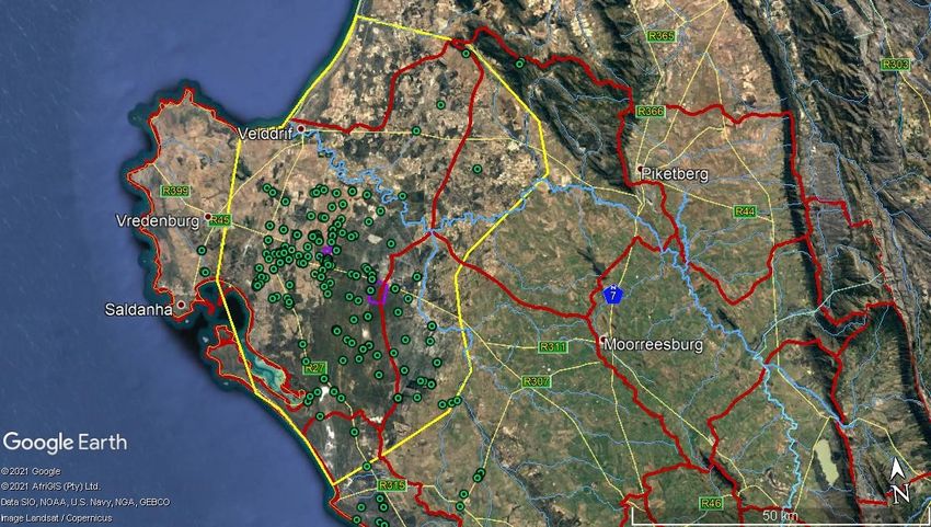
The approximate model area is 2676 km2 and shown in figure 1 by the yellow polygon.
Figure 1: The proposed modeling area (yellow polygon), with the Langebaan Rd wellfield and its extension in
red, the Hopefield wellfield in purple and the proposed Koningsvlei wellfield in blue. Only shown boreholes
and dug wells with relatively good monitoring data.Figure 2: A close-up view of the wellfields.
The primary purpose of the models is to provide data input to the WfMS.
The geological model (when fully developed it is expected to consist of a conceptual geological model, a
spatial geological digital model and a hydrostratigraphical model) and the flow model shall be developed
using existing data such as borehole data, geophysical data, and existing geological and hydrological models
as well as the newly gathered SkyTEM data, that will be made available by SBLM. Digitalization of relevant
analogue data shall be expected as part of the project.
The geological model shall be done using the software GeoScene3D.
Both models shall be handed over to SBLM after the project period in a format, so other consultants can
use it, eventually with use of other types of software.
Nicolette Vermaak of the University of Free State has worked in the area for many years. Her work is part of
her Ph.D., and she has been kind to make her thesis and other relevant data available to the project – see
Appendix 2 and this link: https://filkassen.statens-it.dk/u/sivr7Myr66WgK-vn/Saldanha%202021?l If there
are any questions to the material, Nicolette can be contacted at nokkie.vermaak@gmail.com and phone:
+27-874478787.
Deliverables
- A regional 3D geological model, made with the software GeoScene3D
- A regional 3D flow model
- Technical reports on both models- Written inputs to the development of a South African Groundwater Mapping and Assessment
Approach (SAGMAA) - developed in a parallel project. The consultant to do this is expected to be in
place in April, and first draft version of the SAGMAA is planned ultimo August.
Note with regard to the offer, that:
1. Due to project period constraints, it may be necessary to simplify one or both models, calling for
prioritization. In the offer shall be included a proposal for how to optimize the model development
within the limited project period and still get a functional model, that can provide inputs to the
WfMS, as this will form part of the evaluation of the offer.
Budget
The maximum cap for the assignment is 800.000 DKK inclusive of reimbursements, and per diem.
Payment is in two rates, the first after completion of activity B.1 and the final after completion of the
project. If preferred, additional rates can be agreed upon, in which case the rates will be based on progress
documentation (short progress report and documentation of spending of time (person-hours), per diem
and reimbursements).
Note with regard to the offer, that:
1. It will be weighed positively that the offered price is as low as possible (see Advertisement
conditions).
2. The total proposed price for the assignment should include phase A+B, including capacity building.
3. The proposed budget shall be detailed to a level, so that the background for the total price can be
understood.
4. The offer must include planned person-hours for each of the proposed participants for each of the
different activities/tasks. This will give insights to how the work is planned.
5. The budget for phase A should include a minimum of two years of license and support for the system.Timeline
The overall duration of the project is 8 months (May-Dec 2021). In the chart, the tentative further activities
(outside of this tender) is indicated – lighter blue and italics.
Activity Project period (May-Dec 2021) Tentative further activities (months from
initiation)
- Not part of the project
M J J A S O N D 1 2 3 4 5 6 7 8 9 10 11
Capacity building
A.1 Development of a
Phase A
Wellfield Management
System (WfMS)
B.1 Geological Model
Phase B
B.2 Flow Model
C.1 Rolling-out of the
Phase C (not included in project)
WfMS, including supple-
menting monitoring net-
work
C.2 Testing of the WfMS in
practice
C.3 Alteration of WfMS
based on the testing
C.4 Local and wellfield
models
Organizational setup
There will be a steering committee (SC) with representatives from Danish Environmental Protection Agency
(EPA), the South African Department of Water and Sanitation (DWS) and the SBLM. Based on inputs from
the offer there will be an initial meeting with the SC to decide on details in activities, including capacity
building, purpose of the WfMS and models, and the timeline.
A reference group (RG) of South African stakeholders (e.g. from consultants and universities) to give inputs
to the projects and ensure coordination with parallel activities.
It will be the responsibility of the consultant to arrange SC and RG meetings.Qualifications of the consultants
The consultant or consultants group is from a consultant company or consultant companies with a
combined deep understanding and expertise from developing wellfield management systems and
geological models and flow models.
One company acts as main contractor, and the other consultant or consultants acts as subcontractors.
The following qualifications and previous experiences should be met from the consultant or consultant
group:
Experience and Knowledge:
o Ideally, have 15+ years of in depth relevant experience.
o Knowledge of international best practice in groundwater models and water supply
management systems.
o Experience with setting up water supply management systems.
o Experience with the Danish groundwater mapping approach and the software GeoScene3D.
Qualifications and Skills:
o Be fluent in English (writing and speaking)
o Formal qualifications in the appropriate fields, natural resource management, civil
engineering or hydrogeology.
o Strong communication skills and ability to follow through and cooperate on a distance –
especially during a pandemic, where physical presence of non-South Africans in South
Africa may be difficult.
As a service for preparing the offer, a short list of South African consultants that have worked in the
Saldanha Bay area is included in Appendix 3. Note for the sake of good order, that the use of the mentioned
consultants or other South African personnel in itself are not a mandatory requirement in the project, as
long as the qualifications are met by one consultant or the consultant group.Appendix 1. Background – new investigations Saldanha Bay area Saldanha Bay Municipality is at the moment augmenting the bulk water supply from the Berg River systems with three groundwater well fields (Langebaan Road, Langebaan Road extension and Hopefield). The three wellfields are in the primary aquifer (Langebaan Road aquifer) and the last two are newly developed. The Koningsvlei area is identified as one of two additional wellfields to be developed with a possibility of a seawater desalination plant in the near future. The Council for Scientific and Industrial Research (CSIR), University of Western Cape (UWC) and DWS is in the final stages of a Water Research Commission (WRC) project that investigated aquifer development and recharge. It also investigated the potential for implementation of a managed aquifer recharge (MAR) for additional water storage and the best suitable MAR method to be used. The project also focuses on the development of a management plan for Langebaan Road Aquifer system considering the implementation of MAR. A large airborne geophysics survey was conducted May-June 2020. Danish company SkyTEM did the survey. A research project (MARSA), has recently been started, which aims at developing MAR technologies that allow for a broader span of water resources to be used for MAR, including storm water, river water, saline water, and treated wastewater. This project is a collaboration between various South African and Danish partners from Universities and public and private institutions and it is coordinated by Danish Geological Survey (GEUS). It will include development of new monitoring strategies for the technologies and an assessment of the water saving achieved by implementing MAR on a larger scale in SA with focus on the West Coast District Municipality of which SBLM is a part. This research project will also focus on a field location where Berg River water will be used for MAR. The study will also determine at what concentration levels saline water can be used directly for MAR or where a pre-treatment is required as salinity varies along the river. Feasibility studies will be carried out as flow through columns to investigate the capacity of SA aquifer sediments to remove N-species, organic pollutants and potential pathogens present in the Berg river. Two postdocs will be hired, one in Denmark and one in South Africa working closely together on both the feasibility and field studies.
Appendix 2 – Overview of existing data
   The table shows an initial overview of availability and formats of relevant data for the area.

   Abbreviations/description of Data bases:
   NGA: National Groundwater Archives. – Geosite information (borehole, dug well, spring, etc.)
   Hydstra: Monitoring data - groundwater levels, surface water flow, etc.
   WMS: Water Management System – Water quality (surface and groundwater)
   WARMS: Water Authorization Registration Management System – Water use registration information

Data                Description                    Available                           Format

Boreholes/wells     The position and elevation     Yes                                 Excel
                    of existing boreholes/wells    Information exists for about        spreadsheet;
                    (x, y, z coordinates).         2000 boreholes on the NGA           NGA; reports
                    Lithological information       Yes                                 Excel
                    from the boreholes/wells.      There are about 800 boreholes       spreadsheet;
                                                   with fairly reliable lithological   NGA; reports
                                                   logs, with about 120 that have
                                                   stratigraphic information giving
                                                   the formation
                    The location of the well       Yes                                 Excel
                    screen – depth and length      Approximately 800 of the            spreadsheet;
                    of the screen.                 boreholes will have greater         NGA; reports
                                                   details on borehole
                                                   construction; older boreholes
                                                   that were recorded during
                                                   hydrocensus work and private
                                                   boreholes often does not have
                                                   this level of information
                    The hydraulic head             Yes                                 Excel
                    measurements from the          Water level readings (hydraulic     spreadsheet;
                    boreholes/wells.               head measurements) have been        NGA; Hydstra;
                                                   done fairly regularly for           reports
                                                   approximately 200 boreholes
                                                   and dug wells in the area
                    Borehole logs, for example     Yes
                    flow logs                      Geophysics may be available at
                                                   a number of boreholes.
Digital elevation   A digital terrain model        Yes
model (DEM)         (grid)
Water chemistry     Results from analysis of the   Yes                                 Excel
                    groundwater chemistry.         Data is available for a number      spreadsheet;
                                                   of boreholes. 25 made up the        WMS; reports
                                                   regular official water quality
                                                   monitoring the last couple of
                                                   years.
Geologic            Digital maps that can          Yes
information         provide information on the
geologic units in the study Need to contact Council of
area. For example, a map Geoscience (CGS)
showing the location of the
dolerite dykes/sills.
Literature on the Reports Yes* Some reports are
area’s geology Articles available digitally
PhD Thesis (GH Reports);
others still only in
hard copy.
A number of
reports are
written in
Afrikaans.
Geophysical Existing geophysical Yes
surveys surveys performed in the SkyTEM data from SBLM.
area (e.g. resistivity Historical data form reports in
measurements, seismic hard copy; raw data may not be
mapping) available
Rivers A shape file/tab file Yes
showing the location of the
rivers
Hydraulic head Yes. Hydstra
measurements
Discharge measurements Yes Excel
For some of the rivers. Number spreadsheet,
of stations along Berg River; Hydstra
some stations closed
Will request most recent data
from DWS Bellville
Information on whether Yes
there are rivers that dry Quite a number of non-
out during the summer perennial rivers in the study
period . area, where the whole river or
part of the river dries up.
River cross sections ?
Climatic data Time distributed Yes
precipitation for last 5-10 Fairly complete data set up to
years, on daily basis 2012; more recent data from
South African Weather Services
Time distributed Potential Yes
evaporation for last 5-10 Information not freely available,
years, on daily basis but can be sourced. Data from
Department of Agriculture in
the Western Cape
Groundwater An identification of which Yes WARMS data
abstraction wells groundwater is base
extracted from.
The total amount of water Yes WARMS data
extracted from the wells baseper year. Here, it would be
nice to have the yearly
amount of water extraction
shown over a specific time
period.
The maximum permitted Yes WARMS data
water extraction per year base
(if available).
Transmissivity Information on the Yes Excel
transmissivity of the spreadsheet;
geological units derived NGA; reports
from pumping
tests/aquifer tests.
Maps showing zones where Need to contact CGS to
the geologic units are more determine availability
fractured than in other
locations
Information on the Yes Excel
transmissivity of the spreadsheet;
geological units derived NGA; reports
from blow test
Other hydraulic Methods for determination Yes Excel
tests in fractured of water transport in spreadsheet;
rocks fractures for example from NGA; reports
single-hole hydraulic
injection tests
Potentiometric A potentiometric surface Yes Old reports
surface maps map showing the level of
the water table.
Land use Land use Theme as basis Yes Western Cape
for calculation of Farm Mapper;
evaporation reports
*A number of reports was provided in the Filkassen: https://filkassen.statens-it.dk/u/sivr7Myr66WgK-
vn/Saldanha%202021?l.:
- Geotechnical reports from the DWS regarding the exploration in the area (GH-reports: GH3224,
GH3370; GH3371; GH3372; GH3373; GH3374; and GH3375) with attachments (maps, etc.) for two
of them.
- Report 23-11-1-17 is a WRC report in which one of the case studies is on the study area.
- Rep9-Vol6-GW Langebaan Aquifer is a water resource assessment that was done for DWS in 2008.
- Ph.D. thesis Nicolette VermaakAppendix 3 - List of some South African consultants that have worked in the Saldanha Bay area Name: Organisation: Email: Julian Conrad GEOSS jconrad@geoss.co.za Helen Seyler Delta H helen@delta-h.co.za Kornelius Riemann Umvoto Africa kornelius@umvoto.com Regan Rose Jeffers & Green Africa roser@jgafrika.com Sumaya Israel University of Western Cape sisrael@uwc.ac.za Des Visser SRK DVisser@srk.co.za
You can also read