Compilation of Information on Occurrence and Conservation Status for the Freshwater Mussel Fauna of Nebraska, Kansas, and Oklahoma
←
→
Page content transcription
If your browser does not render page correctly, please read the page content below
Species Management Research Program
Prepared in cooperation with the Bureau of Land Management

Compilation of Information on Occurrence and Conservation
Status for the Freshwater Mussel Fauna of Nebraska,
Kansas, and Oklahoma

Data Series 1133

U.S. Department of the Interior
U.S. Geological Survey
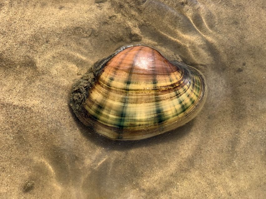
Cover. The freshwater mussel Lampsilis cardium (plain pocketbook), one of the six focal species in
the freshwater mussel assemblage evaluated for the project area, which covers Nebraska, Kansas,
and Oklahoma. Photograph by Teresa Newton, U.S. Geological Survey.
Compilation of Information on Occurrence
and Conservation Status for the Freshwater
Mussel Fauna of Nebraska, Kansas,
and Oklahoma

By Natasha B. Carr and Tammy S. Fancher

Species Management Research Program

Prepared in cooperation with the Bureau of Land Management

Data Series 1133

U.S. Department of the Interior
U.S. Geological Survey
U.S. Geological Survey, Reston, Virginia: 2021 For more information on the USGS—the Federal source for science about the Earth, its natural and living resources, natural hazards, and the environment—visit https://www.usgs.gov or call 1–888–ASK–USGS. For an overview of USGS information products, including maps, imagery, and publications, visit https://store.usgs.gov/. Any use of trade, firm, or product names is for descriptive purposes only and does not imply endorsement by the U.S. Government. Although this information product, for the most part, is in the public domain, it also may contain copyrighted materials as noted in the text. Permission to reproduce copyrighted items must be secured from the copyright owner. Suggested citation: Carr, N.B., and Fancher, T.S., 2021, Compilation of information on occurrence and conservation status for the freshwater mussel fauna of Nebraska, Kansas, and Oklahoma: U.S. Geological Survey Data Series 1133, 22 p., https://doi.org/10.3133/ds1133. Data associated with this publication: Fancher, T.S., and Carr, N.B., 2021, Distribution of a freshwater mussel assemblage in Kansas, Nebraska, and Oklahoma: U.S. Geological Survey data release, https://doi.org/10.5066/P9SBFZJU. ISSN 2327-638X (online)
iii

Acknowledgments
Funding for this work was provided by the U.S. Department of the Interior, Bureau of Land
Management. Assistance with data compilation was provided by Lucy Burris and Gordon
Reese, formerly with the U.S. Geological Survey. We thank the Kansas Department of Health
and Environment for providing the mussel survey data for Kansas and reviewing the draft data
series. Reviews of the draft data series were provided by Teresa Newton and Nathan Kleist of
the U.S. Geological Survey.
v

Contents
Abstract�����������������������������������������������������������������������������������������������������������������������������������������������������������1
Introduction����������������������������������������������������������������������������������������������������������������������������������������������������1
     Freshwater Mussel Life History���������������������������������������������������������������������������������������������������������4
            Freshwater Mussel Guilds���������������������������������������������������������������������������������������������������������4
Methods����������������������������������������������������������������������������������������������������������������������������������������������������������5
     Assignment of Time Periods���������������������������������������������������������������������������������������������������������������5
     Overview of State-Level Surveys�������������������������������������������������������������������������������������������������������6
            Nebraska���������������������������������������������������������������������������������������������������������������������������������������6
            Kansas�������������������������������������������������������������������������������������������������������������������������������������������7
            Oklahoma��������������������������������������������������������������������������������������������������������������������������������������7
     The Freshwater Mussel Fauna�����������������������������������������������������������������������������������������������������������7
     The Freshwater Mussel Assemblage������������������������������������������������������������������������������������������������7
Results�����������������������������������������������������������������������������������������������������������������������������������������������������������10
     Conservation Status and Distribution Patterns of the Freshwater Mussel Fauna������������������10
     Distribution of the Freshwater Mussel Assemblage��������������������������������������������������������������������10
Discussion�����������������������������������������������������������������������������������������������������������������������������������������������������18
     Dataset Limitations�����������������������������������������������������������������������������������������������������������������������������18
Summary�������������������������������������������������������������������������������������������������������������������������������������������������������19
References Cited�����������������������������������������������������������������������������������������������������������������������������������������19

Figures
         1.     Map showing hydrologic subregions used for summarizing the contemporary
                distribution of the freshwater mussel assemblage in Nebraska, Kansas, and
                Oklahoma���������������������������������������������������������������������������������������������������������������������������������������3
         2.     Map showing the distribution of Amblema plicata in Nebraska, Kansas, and
                Oklahoma�������������������������������������������������������������������������������������������������������������������������������������12
         3.     Map showing the distribution of Fusconaia flava in Nebraska, Kansas, and
                Oklahoma�������������������������������������������������������������������������������������������������������������������������������������13
         4.     Map showing the distribution of Lampsilis cardium in Nebraska, Kansas, and
                Oklahoma�������������������������������������������������������������������������������������������������������������������������������������14
         5.     Map showing the distribution of Lampsilis teres in Nebraska, Kansas, and
                Oklahoma�������������������������������������������������������������������������������������������������������������������������������������15
         6.     Map showing the distribution of Pyganodon grandis in Nebraska, Kansas, and
                Oklahoma�������������������������������������������������������������������������������������������������������������������������������������16
         7.     Map showing the distribution of Uniomerus tetralasmus in Nebraska, Kansas,
                and Oklahoma������������������������������������������������������������������������������������������������������������������������������17
vi
Tables
1. Habitat association, life history strategy, thermal tolerance, and reproductive
characteristics of species in the freshwater mussel assemblage mapped in
Nebraska, Kansas, and Oklahoma���������������������������������������������������������������������������������������������5
2. Data sources, type, geographic extent, and survey time periods used for
mapping the distribution of the freshwater mussel assemblage in Nebraska,
Kansas, and Oklahoma����������������������������������������������������������������������������������������������������������������6
3. Number of occurrence records used for mapping the distribution of focal
species in the freshwater mussel assemblage in Nebraska, Kansas, and
Oklahoma���������������������������������������������������������������������������������������������������������������������������������������6
4. Distribution classes and conservation status for extant and extirpated
freshwater mussels mapped in Nebraska, Kansas, and Oklahoma�������������������������������������8
5. Contemporary occurrence records for the freshwater mussel assemblage by
subregions and subbasins in Nebraska, Kansas, and Oklahoma���������������������������������������11
Abbreviations
GBIF Global Biodiversity Information Facility
KDHE Kansas Department of Health and Environment
REA Rapid Ecoregional Assessment
SGP Southern Great Plains
USGS U.S. Geological SurveyCompilation of Information on Occurrence and Conservation
Status for the Freshwater Mussel Fauna of Nebraska,
Kansas, and Oklahoma
By Natasha B. Carr and Tammy S. Fancher
of all subbasins and slightly more than half of the subregions,
Abstract primarily along the eastern portion of the three-State area.
Lampsilis teres and Uniomerus tetralasmus were more
The purpose of this data series is to compile information widespread, occurring in close to half of the subbasins and
on the occurrence and conservation status of the freshwater about three-quarters of the subregions. Pyganodon grandis
mussel fauna of Nebraska, Kansas, and Oklahoma and to was the most widespread, occurring in about three-quarters
map the distribution of a freshwater mussel assemblage of the subbasins and almost all subregions. There were
for the U.S. Department of the Interior, Bureau of Land very few subbasins with historical occurrences that lacked
Management Rapid Ecoregional Assessment (REA) program. contemporary occurrences. The broad-scale distribution
The six focal species in the freshwater mussel assemblage maps for the freshwater mussel assemblage presented with
are Amblema plicata (threeridge), Fusconaia flava (Wabash this report are intended to contribute baseline information for
pigtoe), Lampsilis cardium (plain pocketbook), Lampsilis regional assessments, such as the Southern Great Plains Rapid
teres (yellow sandshell), Pyganodon grandis (giant floater), Ecoregional Assessment. Despite the limitations of the available
and Uniomerus tetralasmus (pondhorn). The focal species data, such baseline information can be useful for identifying
were selected using the following criteria: (1) the species are data gaps, monitoring future trends, identifying conservation
regionally significant, (2) occurrence records are sufficient to priorities, and providing the larger context for more detailed
map the distribution of the species by hydrologic subbasins, watershed- or catchment-level studies. ScienceBase data
(3) the assemblage includes species representing a range of release files associated with this data series are available at
State-level conservation priorities, and (4) the species are not https://doi.org/10.5066/P9SBFZJU (Fancher and Carr, 2021).
listed as federally endangered or threatened. In addition, the
species represent a broad array of life history strategies and
habitat associations.
A total of 61 native species of freshwater mussels have Introduction
documented occurrences within at least 1 of the 3 States,
including 6 species that appear to have been extirpated from Regional assessments, such as Rapid Ecoregional
all the States and 6 species that may have been extirpated Assessments (REAs) conducted by the U.S. Department of
from at least 1 State. Of the 61 species, 8 species (including 3 the Interior, Bureau of Land Management, provide multiscale
potentially extirpated species) are listed as federally threatened information for a variety of management applications. The
or endangered and an additional 5 species are ranked as overarching purpose of the REAs is to “facilitate evaluation of
imperiled or vulnerable across their range. Approximately the cumulative effects of management decisions on regionally
80 percent of the native species known to have occurred important species and ecosystems at broad spatial scales”
within the three-State area have a secure conservation status, (Carter and others, 2017). Broad-scale assessments spanning
in comparison to only 40 percent of all freshwater mussel jurisdictional boundaries can provide the larger context for
species or subspecies occurring within the United States. The local or State-level management decisions and can facilitate
compiled records for the contemporary period (1970–2017) cross-jurisdictional coordination of management actions (Carter
documented the occurrence of 24 extant species in Nebraska, and others, 2017). REAs compile and synthesize datasets for
42 in Kansas, and 48 in Oklahoma. one or more ecoregions and evaluate the effects of change
The contemporary distributions of the six focal species agents (drivers of ecological changes that can affect natural
were mapped by subbasins and the larger hydrologic resources, such as development, wildfire, invasive species, and
subregions. Historical records (prior to 1962) were also mapped climate change) on priority species (or species assemblages) and
but were limited. Amblema plicata, Fusconaia flava, and ecological communities, which are collectively referred to as
Lampsilis cardium were present in approximately one-third conservation elements (Assal and others, 2015).2 Information on Occurrence and Conservation Status for the Freshwater Mussel Fauna of Nebraska, Kansas, and Oklahoma
The species evaluated as conservation elements by the Six focal species from the Interior Basin faunal group
REAs are intended to be representative of management issues were selected to represent freshwater mussels in the project
not adequately addressed by evaluating the effects of change area (Tweedy, 2015): Amblema plicata (threeridge), Fusconaia
agents on ecological communities (Reese and others, 2017). flava (Wabash pigtoe), Lampsilis cardium (plain pocketbook),
The REAs use the term “species assemblage” in reference Lampsilis teres (yellow sandshell), Pyganodon grandis (giant
to two or more focal species from a taxonomic group (such floater), and Uniomerus tetralasmus (pondhorn). The focal
as sagebrush-obligate birds, tree-roosting bats, or freshwater species in the freshwater mussel assemblage were selected
mussels) that use similar habitat types and are collectively based on the following criteria: (1) the species are regionally
evaluated as a unit. Although the concept of species significant (occur across all States in the ecoregion and are not
assemblages in ecology usually refers to species co-occurring narrowly distributed; Assal and others, 2015), (2) occurrence
at a local site (for example, Haag and Warren, 2007), the records are sufficient to map the distribution of the species by
REAs apply this concept to the distribution of focal species subbasin, (3) the assemblage includes species representing
at broad spatial scales (such as mussel species co-occurring a range of State-level conservation priorities, and (4) the
within subbasins across a region of interest). species are not listed as federally endangered or threatened.
Freshwater mussels (Bivalvia: Unionoidae) were The freshwater mussel assemblage was assumed to be
initially identified as a potential conservation element for the representative of other mussel species in the project area. The
Southern Great Plains REA because of population declines degree to which this assumption is valid depends, in part, on
over the past century resulting from previous harvesting, the spatial extent and ecological processes under consideration
aquatic development, pollution, and threats from invasive (Caro, 2010).
species, as well as vulnerability to climate change (Assal This data series summarizes information on the entire
and others, 2015; Tweedy, 2015). Freshwater mussels are freshwater mussel fauna, and maps the distribution of the
sensitive to altered flow regimes and degraded water quality mussel assemblage, for Nebraska, Kansas, and Oklahoma
(sedimentation and chemical contamination) resulting from (hereafter referred to as project area; fig. 1). Geospatial data
channelization, impoundments, loss of riparian vegetation, and on the distribution of freshwater mussels at broad spatial
adjacent upland development including agriculture, energy extents is typically only available at a coarse resolution
production, mining, roads, and urbanization (Vaughn and corresponding to State boundaries (for example, NatureServe,
Taylor, 1999; Haag, 2012; Haag and Williams, 2014). Of the 2020). To address the need for baseline geospatial data
approximately 300 freshwater mussel species that occur in on the distribution and conservation status of freshwater
the United States, it is estimated that 30 species or subspecies mussels in the three-State project area, we compiled a list
have become extinct, primarily as a result of dam installation of all documented extant and extirpated freshwater mussel
(Haag and Williams, 2014). Close to 60 percent of extant species and synthesized information on their distribution and
species or subspecies are imperiled or vulnerable, including conservation status. We used occurrence records to map the
93 species listed as federally threatened or endangered contemporary distribution of focal species in the freshwater
(NatureServe, 2020; U.S. Fish and Wildlife Service, 2020). mussel assemblage at two levels of nested hydrologic
Unexplained catastrophic declines of mussel populations in units: subbasins and subregions (U.S. Geological Survey
streams that otherwise support healthy fish and other aquatic and U.S. Department of Agriculture, 2013). Subbasins
invertebrate populations underscore the threats to mussel (fourth-level, 8-digit hydrologic unit) are nested within
populations (Haag and Williams, 2014; Haag, 2019). Even subregions (second-level, 4-digit hydrologic unit; fig. 1).
widespread and common species have experienced population All subregions in the project area are nested within two
declines (Galbraith and others, 2018). regions (first level, 2-digit hydrologic unit): the Missouri and
Freshwater mussels have many characteristics that Arkansas-White-Red regions. By mapping the distribution
make them suitable as indicator species, including broad of focal species at a finer resolution and broader spatial
interspecific variation in tolerance to contaminants and extent than State-level distribution maps, this data series and
altered habitat conditions (Williams and others, 1993; associated data release (Fancher and Carr, 2021) address an
Grabarkeiwicz and Davis, 2008). In addition, declines in the information gap identified by the SGP REA (Assal and others,
abundance and diversity of mussel faunas can have significant 2015; Reese and others, 2018).
ecological consequences. Mussels often dominate the biomass The associated data release (Fancher and Carr, 2021)
of the stream benthos (Williams and others, 1993; Haag summarizes occurrence records for the freshwater mussel
and Williams, 2014) and contribute to crucial ecosystem assemblage by the 8-digit hydrologic unit code, which
functions including stabilizing substrates, cycling nutrients, identifies the region, subregion, and subbasin (see figs. 2, 3, 4,
and providing food and habitat for other species (Angelo and 5, 6, and 7 for graphical representations of the data release).
others, 2009; Vaughn, 2010, 2018; Vaughn and others, 2004). For each subbasin, the data release provides occurrence
Continued declines in populations of freshwater mussels could information for each of the six focal species, including time
negatively affect such ecosystem functions (Galbraith and period, data source, and number of occurrence records.
others, 2018). Such multiscale baseline information can be useful for
evaluating mussel population status and trends, identifyingIntroduction 3
Cheyenne Missouri-Big
43° –103° Missouri-White –101° –99° Sioux
–97°
Niobrara
Elkhorn Missouri-
Little Sioux
North Platte
Loup
NEBRASKA
41°
South Platte
Platte
Missouri-
Nishnabotna
Republican Kansas –95°
Smoky Hills Lower
39° Missouri
KANSAS
Gasconade-
Osage
Upper
Arkansas Middle Arkansas
Upper Cimarron Neosho-Verdigris
37°
Arkansas-Keystone
SD MN Lower Cimarron
WY
IA OKLAHOMA Lower
Southern
Great Plains
NE North Canadian Arkansas
Rapid Ecoregional
Assessment
boundary CO
KS
Lower
MO Canadian
35° Red
Headwaters
OK
AR Red-Washita
NM
TX Red-Sulphur
Map
area Red-Washita
Base from U.S. Geological Survey digital data 0 50 100 150 MILES
National Atlas of the United States, 2005
National Hydrography Dataset Plus version 2 0 50 100 150 KILOMETERS
EXPLANATION
Project area
Subregion boundary
Figure 1. Map showing hydrologic subregions used for summarizing the contemporary distribution of the
freshwater mussel assemblage in Nebraska, Kansas, and Oklahoma. The boundary of the Southern Great
Plains Rapid Ecoregional Assessment is shown in the map inset.4 Information on Occurrence and Conservation Status for the Freshwater Mussel Fauna of Nebraska, Kansas, and Oklahoma
potential restoration areas, and providing the broader conforms to ambient water temperature), which makes them
context for in-depth studies within watersheds, reaches, and vulnerable to fluctuations in water level and temperatures that
subcatchments (Hopkins, 2009; Haag and Williams, 2014; can exceed their thermal tolerances (Galbraith and others,
Freshwater Mollusk Conservation Society, 2016; Popejoy and 2008; Haag and Williams, 2014).
others, 2018).
Although the freshwater mussel assemblage was initially
selected as a conservation element for the SGP REA, the Freshwater Mussel Guilds
spatial extent of species distributions and data limitations The focal species in the freshwater mussel assemblage
ultimately precluded their inclusion in the REA (Reese and represent a broad variety of life history traits, including a
others, 2017). The extent of the project area was based on the range of habitat associations, reproductive characteristics, and
distribution of mussel species from the Interior Basin faunal thermal tolerances (table 1). Freshwater mussel species with
group occurring within States intersecting the SGP boundaries similar life history traits, referred to as a guild, may be useful
(fig. 1). Few species in this faunal group occur within the for evaluating their vulnerability to future environmental
SGP. This faunal group is more diverse and abundant in the change—such as the resistance and resilience of mussel
Eastern Temperate Forests ecoregion, adjacent to the SGP, populations to natural and human-modified streamflow
along the eastern extent of Nebraska, Kansas, and Oklahoma dynamics—and for developing management strategies
where perennial streams and suitable substrates for freshwater (Galbraith and others, 2010; Vaughn, 2010, 2012; Haag, 2012;
mussels are more prevalent (Mather, 2005; Angelo and Gates and others, 2015; Mitchell and others, 2018). Because
others, 2009; Hoke, 2011); consequently, the full extents of species within a guild may respond similarly to environmental
these States were included in the project area. The freshwater variables, the guild approach is sometimes used to make
mussel fauna of northern Texas, which is within the SGP, is inferences about other species for which data are lacking or
primarily aligned with the Texas faunal group (Tweedy, 2015). otherwise not evaluated (Ries and others, 2016).
As a result, Texas was excluded from the project area. Because Haag (2012) identified three mussel life history
mussels are rare or absent in the remaining States (portions strategies—opportunistic, equilibrium, and periodic—
of Colorado, New Mexico, South Dakota, and Wyoming) relating to their ability to withstand dewatering events. At
along the western and northern extent of the SGP, these States one end of the spectrum, opportunistic species have high
were excluded from the project area. In addition, the different growth rates and early reproduction, which favor rapid
spatial extent for the maps of SGP REA change agents and colonization, but low tolerance of desiccation from receding
the limited availability of occurrence records precluded waters. At the other end of the spectrum, equilibrium species
the application of standardized REA methodology used for have long lifespans, which can exceed a century, and lower
evaluating the effects of change agents on the conservation growth rates. They also have thicker shells and the ability
elements (Reese and others, 2017). to seal their shells, which provide resistance to desiccation.
Periodic species represent an intermediate strategy between
Freshwater Mussel Life History the two extremes. Thermal tolerance, associated behavioral
responses to desiccation (such as burrowing or tracking of
Most freshwater mussels require flowing waters, but receding waters), and reproductive characteristics (such as
some species may also occur in ponds, sloughs, lakes, or brood duration, host specificity and infection mode) can be
reservoirs (Haag, 2012). Habitat characteristics that vary related to these life history strategies (Galbraith and others,
among species include streamflow patterns, such as current 2010; Allen and Vaughn, 2009; Vaughn 2010, 2012; Gough
strength, and substrate types. Adult mussels feed on suspended and others, 2012; Ganser and others, 2015; Gates and others,
detritus, algae, bacteria, phytoplankton, zooplankton, and 2015; Mitchell and others, 2018). Species are considered
other microorganisms (Haag, 2012). Unionid mussels have thermally tolerant if they maintain a good physiological
a complex life cycle, which requires a host fish for the condition at warm temperatures (for example, 35 degrees
development and metamorphosis of their parasitic larvae Celsius [°C]), whereas thermally intolerant or sensitive
(glochidia) (Haag, 2012). The species of host fish and degree species exhibit poor physiological condition at warm
of host specialization vary among mussel species. Methods temperatures (Galbraith and others, 2010). The diversity
of host species infection include passive release of glochidia of habitat types and life history traits represented by the
into the water column or more active infection of host fish freshwater mussel assemblage (table 1) may be useful for
using specialized attractive structures that lure the host representing the vulnerability of other species sharing similar
fish. The glochidia attach to the gills of the fish host, where life history traits and regional distribution patterns in the
they become encysted and receive nutrients from the host. project area.
After several weeks, the glochidia metamorphosize into the
juvenile stage, detach from the host, and settle or burrow into
streambed sediments. As adults, freshwater mussels are largely
sedentary and are thermal conformers (body temperatureMethods 5
Table 1. Habitat association, life history strategy, thermal tolerance, and reproductive characteristics of species in the freshwater
mussel assemblage mapped in Nebraska, Kansas, and Oklahoma.
Reproductive characteristics
General habitat Life history Thermal
Focal species Brood Host Host infection
association1 strategy2 tolerance3
duration4 specificity5 mode6
Amblema plicata (threeridge) Lakes and streams; fine and Equilibrium Tolerant Short Generalist Passive
coarse substrates
Fusconaia flava (Wabash pigtoe) Lakes and streams; stable Equilibrium Tolerant Short Specialist Passive
coarse substrates
Lampsilis cardium (plain pocket- Lakes and medium to large Periodic Intolerant Long Specialist Active
book) streams; varied substrates
Lampsilis teres (yellow sandshell) Large, low-gradient streams Opportunistic Intolerant Long Specialist Active
and shallow lakes; fine
substrates
Pyganodon grandis (giant floater) Lakes and low gradient Opportunistic Intolerant Long Generalist Passive
streams; fine substrates
Uniomerus tetralasmus (pondhorn) Sloughs, ponds, and low Periodic Tolerant Long Specialist Passive
gradient streams; fine
substrates
1Grabarkeiwicz and Davis (2008), Haag (2012).
2Haag (2012).
3Anderson (2005), Galbraith and others (2010), Vaughn (2012), Ganser and others (2015), Gates and others (2015), Mitchell and others (2018), Malish and
Woolnough (2019).
4Gates and others (2015).
5Vaughn (2012), Gates and others (2015), Tweedy (2015).
6Gates and others (2015).
Methods 1963 were classified as historical, and survey dates 1970 and
later were classified as contemporary. The break point between
We compiled occurrence records for the six focal species time periods was based on a temporal gap in the occurrence
from published occurrence records and maps. Occurrence records between 1960 and 1970 for KDHE data and between
records for the full project area were compiled from the Global 1962 and 1970 for GBIF data (table 2). Large disparities in
Biodiversity Information Facility (GBIF; Global Biodiversity survey dates summarized by Hoke (2011) and Angelo and
Information Facility, 2017a, b, 2018a, b, c, d). Occurrence others (2009) precluded the use of a narrower date range for
records for Kansas were provided by the Kansas Department the contemporary time period.
of Health and Environment (KDHE) for data summarized in Records attributed as archaeological specimens from
Angelo and others (2009). We digitized mapped occurrences KDHE were classified as historical. All tabular occurrence
of the focal species for Nebraska (Hoke, 2011) and Oklahoma records (GBIF, KDHE) lacking dates were classified as
(Mather, 2005). We also compiled a list of all freshwater unknown. Records attributed as museum vouchers or other
mussel species confirmed for each State from these source published surveys in Hoke (2011) lacked source information
reports and augmented this list with additional species and were classified as unknown. All records in Mather (2005)
confirmed to occur in eastern Oklahoma (Vaughn and Spooner, were classified as contemporary (see “Oklahoma” section).
2004; Galbraith and others, 2008). Because the most recent occurrence records classified as
contemporary were up to several decades old (table 3), the
resulting distribution maps document the mussel species
Assignment of Time Periods previously occurring within a given subbasin, but the maps do
not confirm current presence.
To provide consistency in the dates of mapped
occurrences across State boundaries, we classified survey or
source dates into two time periods: historical or contemporary
(table 2). Survey dates or compiled sources published prior to6 Information on Occurrence and Conservation Status for the Freshwater Mussel Fauna of Nebraska, Kansas, and Oklahoma
Table 2. Data sources, type, geographic extent, and survey time periods used for mapping the distribution of the freshwater mussel
assemblage in Nebraska, Kansas, and Oklahoma.
[GBIF, Global Biodiversity Information Facility; KDHE, Kansas Department of Health and Environment; NA, not available]
Time period
Data source Data type Primary geographic extent
Historical Contemporary
GBIF1 Compiled survey and museum records Nebraska, Kansas, and Oklahoma 1909–1960 1970–2017
Hoke (2011) Surveys Nebraska NA 1972–2000
Hoke (2011)2 Compiled survey and museum records Nebraska Unknown Unknown
KDHE1 Surveys Kansas NA 1990–2006
KDHE3 Compiled survey and museum records Kansas 1885–1962 1970–2006
Mather (2005)4 Compiled survey and museum records Oklahoma NA Unknown
1Occurrence records with dates not specified were classified as unknown.
2Dates of occurrence records from compiled museum vouchers and published surveys could not be determined and were classified as unknown.
3Publication years of compiled surveys prior to 1970 or archaeological specimens were classified as historical.
4Dates of all mapped occurrence records were not defined but were assumed to be 1970 or later and were used to classify occurrences as contemporary.
Table 3. Number of occurrence records used for mapping the distribution of focal species in the freshwater mussel assemblage
in Nebraska, Kansas, and Oklahoma.
[KDHE, Kansas Department of Health and Environment; GBIF, Global Biodiversity Information Facility]
Number of records by data source1
Focal species
KDHE GBIF Hoke2 Mather2 Total
Amblema plicata (threeridge) 1,193 89 40 60 1,382
Fusconaia flava (Wabash pigtoe) 927 68 44 52 1,091
Lampsilis cardium (plain pocketbook) 652 18 56 48 774
Lampsilis teres (yellow sandshell) 721 45 31 69 866
Pyganodon grandis (giant floater) 1,197 75 208 112 1,592
Uniomerus tetralasmus (pondhorn) 704 41 70 52 867
Total of all focal species 5,394 336 449 393 6,572
1Mather (2005); Kansas Department of Health and Environment records were mapped in Angelo and others (2009); Hoke (2011); Global Biodiversity
Information Facility (2017a, b, 2018a, b, c, d)
2Record number reflects the number of digitized locations from published maps.
Overview of State-Level Surveys Nebraska
The published occurrence records were compiled from Hoke (2011) documented the occurrence of 31 native
qualitative surveys, reports, and museum records (table 2). The freshwater mussel species in Nebraska from occurrence
number, dates, and duration of surveys varied considerably records at 680 sites surveyed between 1972 and 2000 as well
among data sources (tables 2 and 3). Although there can be as compiled museum vouchers and published survey records.
limitations associated with nonrandom and qualitative surveys, The survey sites were selected from accessible locations,
especially at local scales, such information can be useful for typically road crossings, and were broadly distributed across
mapping the distributions of freshwater mussels at broad Nebraska (Hoke, 2011, figs. 3 and 4 denote sampling locations).
spatial extents (Obermeyer, 1998). Mussels were detected at 58 percent of survey locations. The
surveys confirmed the presence of 24 extant species at the
time of the surveys, with 1 additional species (Villosa lienosa
[little spectaclecase]) mapped only from museum vouchersMethods 7
(table 4). Six additional species (Lasmigona compressa [creek heelsplitter], and Toxolasma lividum [purple lilliput]) were
heelsplitter], Ligumia recta [black sandshell], Obovaria olivaria previously reported in Oklahoma and could not be verified but
[hickorynut], Ortmanniana ligamentina [mucket], Pleurobema were considered potentially present (Mather, 2005).
clava [clubshell], and Potamilus purpuratus [bleufer]) are The approximate location of each mapped record was
presumed to be extirpated in Nebraska because only relict shells based on descriptions of physical sites (Mather, 2005). Because
were observed during surveys (Hoke, 2011). the data sources for the mapped records were not provided, the
date of these records could not be ascertained. We assumed
that the distribution maps primarily corresponded to the
Kansas contemporary time period (1970 or later) based on a reference
The KDHE conducted comprehensive mussel surveys to “collections, particularly during the past 20 years” and the
between 1990 and 2007 at 2,210 sites (Angelo and others, “current list” presented in comparison to publications from
2009, fig. 2 denotes sampling locations). The sampling 1925, 1971, 1998, 2003, and in press (Mather, 2005, see app.
locations were broadly distributed across Kansas and focused A). However, it is possible that some records used to map the
on perennial and intermittent streams as well as publicly contemporary distribution predated 1970. The contemporary
owned lakes and wetlands. Surveys were repeated twice occurrences in 66 percent of the subbasins documented by
within the survey period for 128 reaches, and an additional Mather (2005) were confirmed by contemporary occurrence
98 (randomly selected) smaller wadeable reaches were records from GBIF, KDHE, or both (Fancher and Carr, 2021).
surveyed in 2006 and 2007 (Angelo and others, 2009). Live
mussels, unweathered shells, or both were detected at 54
percent of survey locations indicating extant populations. At
The Freshwater Mussel Fauna
10 percent of survey locations, the lack of live specimens and The native freshwater mussel fauna for the project area
the presence of only weathered or subfossil (heavily worn) was compiled from all extant and potentially extirpated species
mussel shells indicate the potential for local extirpation of a with documented occurrences in at least one of the three States.
species. In addition to the surveys conducted by the KDHE, To assess the relative rarity of the mussel species within the
historical records or contemporary survey records were project area, we classified the spatial extent of all species with
compiled from other sources; record types (museum voucher mapped distributions—as well as four unmapped species listed
or archaeological specimen), date of publication (prior to as extirpated—by State using the following four categories: (1)
1970), or both were used to classify these ancillary records as absent (no documented occurrences), (2) possibly extirpated
historical (Angelo and others, 2009). (museum vouchers, but no living specimens in contemporary
These extensive surveys over 18 years documented the surveys), (3) isolated or narrowly distributed populations,
presence of live individuals of 42 mussel species (table 4). and (4) widely distributed (present in more than one-quarter
One additional species (Obovaria olivaria) was represented of the State). The conservation status of each mussel species
only by weathered and subfossil shells and may have been was based on State wildlife action plans (Rohweder, 2015;
extirpated (Angelo and others, 2009). Four additional species Oklahoma Department of Wildlife Conservation, 2016;
previously confirmed in Kansas are presumed to have Schneider and others, 2018), and at the national level using
been extirpated (Alasmidonta viridis [slippershell mussel], NatureServe Conservation Status Ranks (NatureServe, 2020)
Epioblasma triquetra [snuffbox], Lasmigona compressa, and species listed as federally threatened or endangered (U.S.
and Quadrula fragosa [winged mapleleaf mussel]; table 4). Fish and Wildlife Service, 2020). Most of the native mussel
An additional five species were reported in Kansas but lack species occurring within the project area are widely distributed
museum vouchers; these species (Lampsilis abrupta [pink throughout the Mississippi Basin (Williams and others, 1993)
mucket], Lampsilis satura [sandbank pocketbook], Leptodea and the western periphery of the range for many of these
leptodon [scaleshell], Plethobasus cyphyus [sheepnose], and species occurs along the eastern side of the project area.
Reginaia ebena [ebonyshell]) may have been extirpated.
The Freshwater Mussel Assemblage
Oklahoma
Published maps for the freshwater mussel assemblage for
Mather (2005) mapped the distribution of 43 extant
Nebraska in Hoke (2011) and for Oklahoma in Mather (2005)
mussel species in Oklahoma—as well as 2 species (Cyprogenia
were georeferenced, and mapped locations were digitized
aberti [western fanshell] and Ligumia recta) that are presumed
onscreen and saved as shapefiles (Fancher and Carr, 2021). Map
to have been extirpated—based on a compilation of occurrence
information on data sources (living or subfossil) provided in
records (table 4). Vaughn and Spooner (2004) and Galbraith
Hoke (2011) was captured as attributes. Tabular data provided
and others (2008) documented the presence of five additional
by KDHE and GBIF were standardized to a common format,
species (Lampsilis satura, Pleurobema rubrum [pyramid
and all records lacking location information were dropped.
pigtoe], Quadrula fragosa, Q. nobilis [gulf mapleleaf], and
Tabular data were converted to shapefiles. All geoprocessing
Toxolasma texasiense [Texas lilliput]) in Oklahoma. Three
was completed using ArcMap 10.3.1 (Esri, 2014).
species (Obovaria olivaria, Potamilus amphichaenus [Texas8 Information on Occurrence and Conservation Status for the Freshwater Mussel Fauna of Nebraska, Kansas, and Oklahoma
Table 4. Distribution classes and conservation status for extant and extirpated freshwater mussels mapped in Nebraska, Kansas, and
Oklahoma.
[All scientific names are from ITIS (2020). Distributions were classified using published distribution maps and summarized information for each species in
Nebraska (Hoke, 2011), Kansas (Angelo and others, 2009), and Oklahoma (Mather, 2005). Species included in the freshwater mussel assemblage are shaded.
Distribution class—A, absent; X, possibly extirpated; I, isolated or narrowly distributed populations; W, widely distributed]
Distribution class
Species Rangewide conservation status
Nebraska Kansas Oklahoma
Alasmidonta marginata A I1 I2 Apparently secure3
Alasmidonta viridis A X A Apparently secure3
Amblema plicata W2 W W Secure3
Amphinaias nodulata A I2 I2 Apparently secure3
Amphinaias pustulosa W1 W W Secure3
Anodontoides ferussacianus W I2 A Secure3
Arcidens confragosus I I1 I Apparently secure3
Arcidens wheeleri A A I Federally endangered4
Cyclonaias tuberculata A I2 A Secure3
Cyprogenia aberti A I1 X1 Imperilled3
Ellipsaria lineolata A I1 I1 Apparently secure3
Elliptio dilatata A I2 I Secure3
Epioblasma triquetra A X A Federally endangered4
Fusconaia flava W W2 W Secure3
Fusconaia ozarkensis A I A2 Vulnerable3
Lampsilis cardium W1 W2 W Secure3
Lampsilis hydiana A A I2 Apparently secure3
Lampsilis rafinesqueana A I1 I Federally endangered4
Lampsilis siliquoidea W2 W2 I Secure3
Lampsilis satura5 A A I Imperilled3
Lampsilis teres W2 W2 W Secure3
Lasmigona complanata W W W Secure3
Lasmigona compressa X X A Secure3
Lasmigona costata A I1 I Secure3
Leptodea fragilis W W W Secure3
Leptodea leptodon I1 A I2 Federally endangered4
Ligumia recta X I X Apparently secure3
Ligumia subrostrata W2 W W Secure3
Margaritifera monodonta A X A Federally endangered4
Megalonaias nervosa A I2 I3 Secure3
Obliquaria reflexa A I W Secure3
Obovaria arkansasensis A A I1 Not rated3
Obovaria olivaria X X A Apparently secure3
Ortmanniana ligamentina X I1 I Secure3
Plectomerus dombeyanus A A I Secure3
Pleurobema clava X A A Federally endangered4
Pleurobema rubrum5 A A I Imperilled3
Pleurobema sintoxia A I2 I Apparently secure3Methods 9
Table 4. Distribution classes and conservation status for extant and extirpated freshwater mussels mapped in Nebraska, Kansas, and
Oklahoma.—Continued
[All scientific names are from ITIS (2020). Distributions were classified using published distribution maps and summarized information for each species in
Nebraska (Hoke, 2011), Kansas (Angelo and others, 2009), and Oklahoma (Mather, 2005). Species included in the freshwater mussel assemblage are shaded.
Distribution class—A, absent; X, possibly extirpated; I, isolated or narrowly distributed populations; W, widely distributed]
Distribution class
Species Rangewide conservation status
Nebraska Kansas Oklahoma
Potamilus alatus I I2 A Secure3
Potamilus ohiensis W W W Secure3
Potamilus purpuratus X W2 W Secure3
Ptychobranchus occidentalis A I1 I Vulnerable3
Pyganodon grandis W W W Secure3
Quadrula apiculata A A W Secure3
Quadrula fragosa5 A X I1 Federally endangered4
Quadrula nobilis6 A A I Apparently secure3
Quadrula quadrula W W W Secure3
Strophitus undulatus W W2 I Secure3
Theliderma cylindrica A I1 I2 Federally threatened4
Theliderma metanevra A I I Apparently secure3
Toxolasma parvum I W2 W Secure3
Toxolasma texasiense5 A A I2 Apparently secure3
Tritogonia verrucosa I1 W W Apparently secure3
Truncilla donaciformis I I2 I Secure3
Truncilla truncata I I2 I Secure3
Uniomerus tetralasmus W W2 W Secure3
Utterbackia imbecillis W W W Secure3
Utterbackia suborbiculata I1 I1 I Secure3
Venustaconcha ellipsiformis A I1 A Apparently secure3
Villosa iris A A I Secure3
Villosa lienosa X A I Secure3
1Tier 1 (highest priority species of greatest conservation need in State wildlife action plans; Rohweder, 2015; Oklahoma Department of Wildlife Conservation,
2016; Schneider and others, 2018).
2Tier 2 (second priority species of greatest conservation need in State wildlife action plans; Rohweder, 2015; Oklahoma Department of Wildlife Conservation,
2016; Schneider and others, 2018).
3NatureServe (2020). Imperiled (at high risk of extinction), vulnerable (at moderate risk of extinction), apparently secure (at fairly low risk of extinction), and
secure (at very low risk of extinction).
4U.S. Fish and Wildlife Service (2020).
5Galbraith and others (2008).
6Vaughn and Spooner (2004).
After eliminating records located outside of the Hoke, 2011) may represent multiple records from a location,
project-area boundary, the remaining 6,572 records were so sample sizes for these data sources reflect the number
used for mapping the distribution of species in the freshwater of mapped locations (table 3). For each focal species, we
mussel assemblage by subbasin (the minimum resolution summarized the occurrences by time period in each subbasin
permitted for publishing the source data) and by subregion. (Fancher and Carr, 2021) and used this information to map
The KDHE provided 82 percent of all records (table 3), most the contemporary, as well as historical-only (contemporary
of which were concentrated in eastern Kansas. However, occurrence records lacking), occurrences by subbasin (figs. 2,
location data compiled from published maps (Mather, 2005; 3, 4, 5, 6, and 7).10 Information on Occurrence and Conservation Status for the Freshwater Mussel Fauna of Nebraska, Kansas, and Oklahoma
Results are of local conservation concern in at least one State
(Tier 1—highest priority or Tier 2—second highest priority,
species of greatest conservation need in State wildlife action
Conservation Status and Distribution Patterns of plans), including 4 of the species in the mussel assemblage
the Freshwater Mussel Fauna (table 4; Rohweder, 2015; Oklahoma Department of Wildlife
Conservation, 2016; Schneider and others, 2018).
The freshwater mussel fauna for the project area included
61 native extant or apparently extirpated species that were
documented to occur in at least one State (table 4), as well Distribution of the Freshwater Mussel
as 2 introduced species: (Corbicula fluminea [Asian clam] Assemblage
and Dreissena polymorpha [zebra mussel]) (Vaughn and
Spooner, 2004; Mather, 2005; Galbraith and others, 2008; All species in the freshwater mussel assemblage were
Angelo and others, 2009; Hoke, 2011). Of the 61 documented widely distributed in all three States (table 4). The core
native species, there were 24 extant species in Nebraska, 42 contemporary distribution for all species in the freshwater
in Kansas, and 48 in Oklahoma. Many of the extant species mussel assemblage is concentrated along the eastern side of
we classified as having isolated populations were represented each State (figs. 2, 3, 4, 5, 6, and 7). Lampsilis cardium had
by only a few contemporary occurrence records and may the most limited distribution, with occurrences in 32 percent
have subsequently become extirpated (Angelo and others, of subbasins and 57 percent of subregions (fig. 4, table 5).
2009). Twelve of the mussel species mapped in the project The distribution of Amblema plicata generally coincides with
area have apparently been extirpated from at least one State that of Fusconaia flava; both species were documented in
(table 4). Cyprogenia aberti, Ligumia recta, Ortmanniana 33 percent of subbasins and 61 percent of subregions (figs. 2
ligamentina, Potamilus purpuratus, Quadrula fragosa, and and 3, table 5). Lampsilis teres was documented in 42 percent
Villosa lienosa have been potentially extirpated in one State of subbasins and 71 percent of subregions (fig. 5, table 5).
but remain present elsewhere in the project area. Alasmidonta Uniomerus tetralasmus was widely distributed across Kansas
viridis, Epioblasma triquetra, Lasmigona compressa, and large portions of Nebraska and Oklahoma, covering 59
Margaritifera monodonta (spectaclecase), Obovaria olivaria, percent of subbasins and 75 percent of subregions (fig. 7,
and Pleurobema clava have apparently been extirpated from table 5). Pyganodon grandis was the most widely distributed
the project area. Seven additional species (Lampsilis abrupta, of all the species, occurring in 73 percent of subbasins and 93
L. reeveiana [Arkansas broken-ray], Plethobasus cyphyus, percent of subregions (fig. 6, table 5). The full complement
Potamilus amphichaenus, Reginaia ebena, Simpsonaias of the six focal species in the mussel assemblage was
ambigua [salamander mussel], and Toxolasma lividum) were documented in 19 percent of subbasins and 57 percent of
listed as possibly extirpated on the basis of their presence subregions (table 5). Because of differences in methods
in neighboring States (Mather, 2005; Hoke, 2011) but were and sampling intensity (table 5), the number of species by
not included in table 4 because there were no documented subbasin or subregions cannot be directly compared across
occurrences of these species within the project area. State boundaries.
Eight of the mussel species in the project area (including Mapped historical records for Nebraska and Oklahoma
three apparently extirpated species) are listed as federally were limited, and most subbasins with only historical mussel
threatened or endangered (U.S. Fish and Wildlife Service, occurrences were in Kansas. The number of subbasins with
2020), and an additional five species are considered imperiled only historical occurrences ranged between 1 and 7 among
(at high risk of extinction) or vulnerable (at moderate risk species (figs. 2, 3, 4, 5, 6, and 7). There is little spatial
of extinction) across their range (NatureServe, 2020). congruence among species for subbasins with only historical
At a national level, 48 species in the project area are not occurrences. However, the historical-only subbasins are
considered at risk (as indicated by national rankings: predominantly along the western edge of the distributions,
apparently secure—at fairly low risk of extinction; indicating the potential for range contraction even for common
secure—at very low risk of extinction) or were “not rated” and widespread species such as Pyganodon grandis and
(NatureServe, 2020); however, 63 percent of these 48 species Uniomerus tetralasmus.Results 11
Table 5. Contemporary occurrence records for the freshwater mussel assemblage by subregions and subbasins in Nebraska, Kansas,
and Oklahoma (see table 2 for dates of contemporary surveys).
[HUC, hydrologic unit code for subregions; AMPL, Amblema plicata; FUFL, Fusconaia flava; LACA, Lampsilis cardium; LATE, L. teres; PYGR, Pyganodon
grandis; UNTE, Uniomerus tetralasmus]
Number of subbasins with occurrence records
Subregion
(by species) Number of
Number records
HUC1 Name AMPL FUFL LACA LATE PYGR UNTE
of subbasins
1012 Cheyenne 2 0 0 0 0 0 0 0
1014 Missouri-White 3 0 0 0 0 1 0 1
1015 Niobrara 7 0 0 0 0 3 0 4
1017 Missouri-Big Sioux 1 1 1 1 1 1 0 16
1018 North Platte 4 0 0 0 0 2 0 8
1019 South Platte 5 0 0 0 0 1 0 3
1020 Platte 6 1 1 2 2 5 3 94
1021 Loup 10 0 0 0 0 6 1 18
1022 Elkhorn 4 2 2 4 2 4 2 81
1023 Missouri-Little Sioux 4 2 1 1 2 2 1 14
1024 Missouri-Nishnabotna 8 6 6 4 6 5 6 281
1025 Republican 17 2 3 4 3 14 14 140
1026 Smoky Hill 15 2 5 4 8 15 15 235
1027 Kansas 11 7 7 9 7 11 11 1,075
1029 Gasconade-Osage 5 4 4 4 4 4 4 763
1030 Lower Missouri 1 1 1 1 1 1 1 177
1102 Upper Arkansas 1 0 0 0 0 0 0 0
1103 Middle Arkansas 18 6 5 4 11 15 16 616
1104 Upper Cimarron 8 0 0 0 0 4 2 32
1105 Lower Cimarron 3 0 0 0 1 3 2 9
1106 Arkansas-Keystone 6 4 3 3 3 6 5 224
1107 Neosho-Verdigris 16 15 15 14 14 15 13 2,312
1109 Lower Canadian 6 0 0 0 1 3 3 12
1110 North Canadian 9 2 1 0 4 4 2 27
1111 Lower Arkansas 5 3 2 2 1 5 4 62
1112 Red Headwaters 5 0 0 0 1 1 2 6
1113 Red-Washita 12 1 4 2 5 9 8 109
1114 Red-Sulphur 9 7 5 6 7 7 4 253
Total number 201 66 66 65 84 147 119 6,572
1The first two digits of the hydrologic unit code (HUC) denote the Missouri Region (10) or the Arkansas-White-Red Region (11).12 Information on Occurrence and Conservation Status for the Freshwater Mussel Fauna of Nebraska, Kansas, and Oklahoma
43° –103° –101° –99°
–97°
NEBRASKA
41°
–95°
39° KANSAS
37°
SD MN
WY
IA OKLAHOMA
NE
CO
KS MO
35°
OK AR
NM
TX Map
area
Base from U.S. Geological Survey digital data 0 50 100 150 MILES
National Atlas of the United States, 2005
National Hydrography Dataset Plus version 2 0 50 100 150 KILOMETERS
EXPLANATION
Time period
Contemporary
Historical only
Unknown
No records
Subregion boundary
Subbasin boundary
Figure 2. Map showing the distribution of Amblema plicata (threeridge) in Nebraska, Kansas, and
Oklahoma.Results 13
43° –103° –101° –99°
–97°
NEBRASKA
41°
–95°
39°
KANSAS
37°
SD MN
OKLAHOMA
WY
IA
NE
CO MO
KS
35°
OK AR
NM
TX Map
area
Base from U.S. Geological Survey digital data 0 50 100 150 MILES
National Atlas of the United States, 2005
National Hydrography Dataset Plus version 2 0 50 100 150 KILOMETERS
EXPLANATION
Time period
Contemporary
Historical only
Unknown
No records
Subregion boundary
Subbasin boundary
Figure 3. Map showing the distribution of Fusconaia flava (Wabash pigtoe) in Nebraska, Kansas, and
Oklahoma.14 Information on Occurrence and Conservation Status for the Freshwater Mussel Fauna of Nebraska, Kansas, and Oklahoma
43° –103° –101° –99°
–97°
NEBRASKA
41°
–95°
39°
KANSAS
37°
MN
SD OKLAHOMA
WY
IA
NE
CO
KS MO
35°
OK AR
NM
TX Map
area
Base from U.S. Geological Survey digital data 0 50 100 150 MILES
National Atlas of the United States, 2005
National Hydrography Dataset Plus version 2 0 50 100 150 KILOMETERS
EXPLANATION
Time period
Contemporary
Historical only
Unknown
No records
Subregion boundary
Subbasin boundary
Figure 4. Map showing the distribution of Lampsilis cardium (plain pocketbook) in Nebraska, Kansas, and
Oklahoma.Results 15
43° –103° –101° –99°
–97°
NEBRASKA
41°
–95°
39°
KANSAS
37°
SD MN
WY
IA
NE OKLAHOMA
CO
KS MO
35°
OK AR
NM
TX Map
area
Base from U.S. Geological Survey digital data 0 50 100 150 MILES
National Atlas of the United States, 2005
National Hydrography Dataset Plus version 2 0 50 100 150 KILOMETERS
EXPLANATION
Time period
Contemporary
Historical only
Unknown
No records
Subregion boundary
Subbasin boundary
Figure 5. Map showing the distribution of Lampsilis teres (yellow sandshell) in Nebraska, Kansas, and
Oklahoma.16 Information on Occurrence and Conservation Status for the Freshwater Mussel Fauna of Nebraska, Kansas, and Oklahoma
43° –103° –101° –99°
–97°
NEBRASKA
41°
–95°
39°
KANSAS
37°
SD MN
WY
IA
NE OKLAHOMA
CO
KS MO
35°
OK AR
NM
TX Map
area
Base from U.S. Geological Survey digital data 0 50 100 150 MILES
National Atlas of the United States, 2005
National Hydrography Dataset Plus version 2 0 50 100 150 KILOMETERS
EXPLANATION
Time period
Contemporary
Historical only
No records
Subregion boundary
Subbasin boundary
Figure 6. Map showing the distribution of Pyganodon grandis (giant floater) in Nebraska, Kansas, and
Oklahoma.Results 17
43° –103° –101° –99°
–97°
NEBRASKA
41°
–95°
39°
KANSAS
37°
SD MN
WY
IA
NE OKLAHOMA
CO
KS MO
35°
OK AR
NM
TX Map
area
Base from U.S. Geological Survey digital data 0 50 100 150 MILES
National Atlas of the United States, 2005
National Hydrography Dataset Plus version 2 0 50 100 150 KILOMETERS
EXPLANATION
Time period
Contemporary
Historical only
No records
Subregion boundary
Subbasin boundary
Figure 7. Map showing the distribution of Uniomerus tetralasmus (pondhorn) in Nebraska, Kansas, and
Oklahoma.18 Information on Occurrence and Conservation Status for the Freshwater Mussel Fauna of Nebraska, Kansas, and Oklahoma
Discussion loads (Fritts and others, 2017). In some areas, improved
water-management activities may be helping to increase
The contemporary distribution maps (figs. 2, 3, 4, 5, 6, the abundance of species that vary in life history strategies
and 7) are graphical representations of the associated data (table 1). For example, between 1991 and 2003, populations of
release (Fancher and Carr, 2021) for the six focal species Fusconaia flava (an equilibrium species) and Lampsilis teres
in the freshwater mussel assemblage. These maps represent (an opportunistic species) both increased in the Verdigris River
the best publicly available geospatial data on the freshwater in Kansas, presumably in response to minimum flow releases
mussel assemblage in Nebraska, Kansas, and Oklahoma, that helped to maintain downstream water levels, lowered flow
which are typically mapped at the State—rather than subbasin rates during peak reservoir discharges, of both (Miller and
or subregion—level. This multiscale, spatially explicit Lynott, 2006).
dataset can provide both baseline information and the larger Although range contractions and population declines
context for more detailed watershed- or catchment-level have been reported for even the most common species in the
studies (Haag, 2012; Freshwater Mollusk Conservation project area, approximately 80 percent of the 61 native species
Society, 2016; Popejoy and others, 2018). Because the (extant or extirpated) known to occur in the project area
populations of many freshwater mussel species are declining are nevertheless considered secure nationwide (table 4). In
in the project area (Galbraith and others, 2008; Angelo and comparison, only 40 percent of all freshwater mussel species
others, 2009), the contemporary distribution maps, which or subspecies in the United States are apparently secure
are based on surveys that may be many decades old, could (NatureServe, 2020). All species in the mussel assemblage
include subbasins in which populations have become locally are considered secure, although the ranges of five species
extirpated. Many mussel species are long lived, however, and have been reported to be contracting in the project area, and
it is recommended that mussel surveys be conducted at least four species are of concern at the State level (table 4). In
15 years apart (Galbraith and others, 2010). Consequently, Kansas, weathered shells or subfossils but (no live specimens)
surveys conducted after 2005 are within the recommended of Amblema plicata, Fusconaia flava, Lampsilis cardium,
sampling frequency and may be similar to current distributions, and Lampsilis teres were found in many subbasins along the
but even older surveys may still reflect the current distribution western periphery of their ranges (figs. 2, 3, 4, and 5; Angelo
for longer-lived equilibrium species (table 1). The documented and others, 2009, figs. A3, A11, A13, and A16), indicating
historical distributions for each species largely overlap their the potential for local extirpations and range contractions.
contemporary distributions except for a small number of Only Pyganodon grandis populations appear to be stable or
subbasins that had only historical records of occurrence (figs. 2, increasing in the project area (Angelo and others, 2009; Hoke
3, 4, 5, 6, and 7). 2011). Local extirpations may be more likely along the edge of
The 6 focal species of the freshwater mussel assemblage distributions where mussels reach the limit of their ecological
possess a variety of life history traits, including a range of tolerances (Angelo and others, 2009; Hoke, 2011). The
thermal tolerances (table 1); thus, the freshwater mussel most widespread species within the project area, Pyganodon
assemblage collectively may be representative of conservation grandis and Uniomerus tetralasmus (figs. 6 and 7), are more
and management issues also relevant to the other 15 species tolerant of harsh conditions (such as low oxygen and low
distributed widely in at least one State in the project area water flows) that become more prevalent along their western
(table 4; Gates and others, 2015). The degree to which the range compared to other species (Gough and others, 2012;
focal species are representative of other mussel species NatureServe, 2020). Dramatic declines in abundance of the
within the same guild depends, in part, on the type and scale focal species have also been reported elsewhere in their range
of ecological processes evaluated (Caro, 2010; Ries and (for example, Haag, 2019).
others, 2016).
Water management and episodic events can locally affect Dataset Limitations
populations of mussel species differently depending on their
life history traits, such as thermal tolerance. For example, the The baseline distribution maps for species in the
effects of a severe drought downstream of impoundments in freshwater mussel assemblage address a priority data
southeastern Oklahoma were magnified by water management, need identified for the Southern Great Plains Rapid
which led to a shift in dominance and abundance of thermally Ecoregional Assessment (Assal and others, 2015) and
tolerant mussel species (including species in the mussel contribute to a priority research need for improved mapping
assemblage) in the Kiamichi River. In contrast, populations of of species distributions across a range of spatial scales
all mussel species were more stable in the Little River, where (Freshwater Mollusk Conservation Society, 2016). There
water releases helped to maintain water levels downstream of are several limitations of the source datasets, however,
the impoundment (Allen and others, 2013). Over longer time that are important to consider for dataset application and
scales, there is also evidence that an increase in nutrient levels interpretation. As with all REA datasets, discontinuities
and eutrophication has led to increased body size for some across State boundaries can result from differences in source
populations of Amblema plicata, a thermally tolerant species dataset methodology (Reese and others, 2017). For example,
that is also relatively tolerant of altered flows and nutrientYou can also read