Cormorant Lakes Watershed District - Watershed Management Plan 2012-2022
←
→
Page content transcription
If your browser does not render page correctly, please read the page content below
Cormorant Lakes Watershed District

      Watershed Management Plan
              2012-2022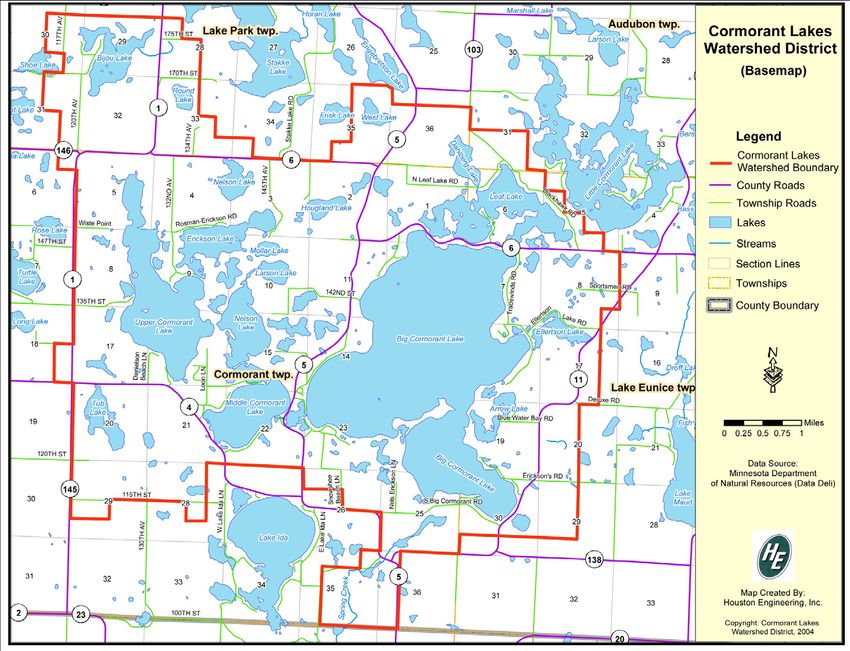
This page intentionally left blank.
ACKNOWLEDGEMENTS
The Cormorant Lakes Watershed District would like to recognize the members of the Advisory Committee
who were appointed to guide the development of the Watershed Management Plan. The CLWD looks
forward to cooperatively working with all of its stakeholders in the implementation of this Plan.

                                     BOARD OF MANAGERS

                                           Ellis Peterson
                                             Jeff Moritz
                                           Jody Beaudine
                                            Gene Olson
                                            Orvis Olson

                           OTHERS WHO WORK WITH THE DISTRICT

                            Duane Henrickson ~ Adminstration Advisor
                                Sherwood Olson ~ Administrator
                                   Sheldon Struble ~ Inspector
                                   Duane Erickson ~ Inspector
                                     Erik Jones ~ Engineer
                                   Rick St-Germain - Engineer
                                    Terry Karkela ~ Attorney
                             Moriya Rufer ~ Water Quality Consultant

                 WATERSHED MANAGEMENT PLAN ADVISORY COMMITTEE

            Member                               Representing
            Benneth Braseth                      Upper Cormorant Lake
            Jay Carlson                          Big Cormorant Lake
            Tim Erickson                         Cormorant Township
            Sean Felker                          Audubon Township
            Brad Grant                           Becker Soil and Water Conservation District
            Lyle Hansen                          Big Cormorant Lake – Wermager Beach
            Joe Herbst                           Bijou Lake
            Jim Kaiser                           Watershed Advisory Board
            Tim James                            Minnesota Pollution Control Agency
            Lloyd Kohler                         Big Cormorant Lake – Blue Water Bay
            Joe Lightowler                       Lake Eunice Township, Big Cormorant Lake Assoc.
            Brad Lindstrom                       Lake Park Township
            George Minerich                      Minnesota Department of Health
            Maggie Metcalf                       Watershed Advisory Board, Middle Cormorant
            Barry Nelson                         Becker County
            Duane Olson                          Watershed Advisory Board, Nelson Lake, Larson Lake
            Chad Severts                         Minnesota Board of Soil & Water Resources
            Jim Wolters                          Minnesota Department of Natural Resources
            Merle Zimmerman                      Big Cormorant Lake Board
Common Acronyms
BMP        Best Management Practice
BWSR       Minnesota Board of Water and Soil Resources
CLWD       Cormorant Lakes Watershed District
DNR        Minnesota Department of Natural Resources
ISTS       Individual Sewage Treatment System
HUC        Hydrologic Unit Code
LA         Lake Association
LGU        Local Governmental Unit
MDA        Minnesota Department of Agriculture
MDH        Minnesota Department of Health
MPCA       Minnesota Pollution Control Agency
OHWL       Ordinary High Water Level
SWCD       Soil and Water Conservation District
TSI        Tropic State Index
USDA       United States Department of Agriculture
WMA        Wildlife Management Area
WPA        Waterfowl Production Area

Cormorant Lakes Watershed District
                                              Watershed Management Plan

TABLE OF CONTENTS

Chapter 1: Introduction

A.    Introduction to the CLWD........................................................................................................................ 1
B.    Original Purpose and Goals ...................................................................................................................... 1
C.    Watershed Rules ....................................................................................................................................... 3
D.    CLWD Evolution ..................................................................................................................................... 3
E.    District’s Mission ..................................................................................................................................... 3
F.    Minnesota Statutory Authority ................................................................................................................. 3

Chapter 2: Description of the CLWD

A. Watershed Setting..................................................................................................................................... 5
       Location and size ............................................................................................................................... 5
       Water flowage .................................................................................................................................... 6
       Political units within the CLWD........................................................................................................ 6
       Population characteristics .................................................................................................................. 8
       The economy...................................................................................................................................... 8
B. Physical Features ...................................................................................................................................... 8
       Climate ............................................................................................................................................... 8
       Topography ........................................................................................................................................ 10
       Geology .............................................................................................................................................. 11
       Soils ................................................................................................................................................... 11
       Land use ............................................................................................................................................. 12
       Public & private land ownership........................................................................................................ 14
C. Water Resources ....................................................................................................................................... 15
       Sub-watersheds .................................................................................................................................. 15
       Rivers and natural streams ................................................................................................................. 15
       Lakes .................................................................................................................................................. 15
       Wetlands ............................................................................................................................................ 16
       Artificial drainage systems ................................................................................................................ 17
       Water management structures ............................................................................................................ 17
D. Existing Programs .................................................................................................................................... 17
       Local .................................................................................................................................................. 17
       State ................................................................................................................................................... 18
       Federal ............................................................................................................................................... 19
       Private ................................................................................................................................................ 19

Chapter 3: Assessment of Resources

A. Water Resources ....................................................................................................................................... 21
      Lake water quality.............................................................................................................................. 21
      Ecoregion comparisons ...................................................................................................................... 23
      Impaired waters.................................................................................................................................. 25

CWLD Plan, 2012-2022                                                Table of Contents                                                                         i
MPCA watershed assessment schedule ............................................................................................. 25
         Fisheries assessments ......................................................................................................................... 26
B.    Shoreline Development ............................................................................................................................ 29
         Shoreline inventory ............................................................................................................................ 29
         Building pressure ............................................................................................................................... 30
         Land use changes ............................................................................................................................... 31
         Subsurface sewage treatment ............................................................................................................. 33
C.    Watershed Assessment ............................................................................................................................. 33
         Erosion risk ........................................................................................................................................ 33
         Erosion potential priority area identification ..................................................................................... 35
D.    Aquatic Invasive Species.......................................................................................................................... 39
         Species present in CLWD .................................................................................................................. 39
         Infestation risks .................................................................................................................................. 39
E.    Watershed Hydrology............................................................................................................................... 40
         Water levels ....................................................................................................................................... 40
         Tree loss ............................................................................................................................................. 41
F.    Habitat Assessment .................................................................................................................................. 41
         High quality habitat............................................................................................................................ 41
         Potential areas for protection ............................................................................................................. 42

Chapter4: Priority Issues

A. Public Meeting ......................................................................................................................................... 45
B. Discussion of Issues ................................................................................................................................. 45

Chapter 5: Implementation Plan

A. Goals, Objectives, and Initiatives Defined ............................................................................................... 47
B. Initiative Formation .................................................................................................................................. 47
C. Implementation Plan................................................................................................................................. 48

Chapter 6: Administration

A. Plan Schedule ........................................................................................................................................... 57
B. Plan Coordination ..................................................................................................................................... 57
C. Intergovernmental Conflict Resolution .................................................................................................... 57
D. Available Funding Mechanisms ............................................................................................................... 57
       Ad valorem tax levies ........................................................................................................................ 57
       Watershed Management Districts ...................................................................................................... 57
       Project Assessments ........................................................................................................................... 57
       Grants ................................................................................................................................................. 57
E. Plan Amendment Procedure ..................................................................................................................... 58
F. Plan Evaluation......................................................................................................................................... 59
G. District Policies ........................................................................................................................................ 59

Appendices
A. Watershed Rules and Regulations ............................................................................................................ 61
B. Erosion Potential Analysis for the Watershed .......................................................................................... 75
C. Public Informational Meeting Comments ................................................................................................ 81
D. 60-day Review Period Comments and District Responses ...................................................................... 85

CWLD Plan, 2012-2022                                                Table of Contents                                                                       ii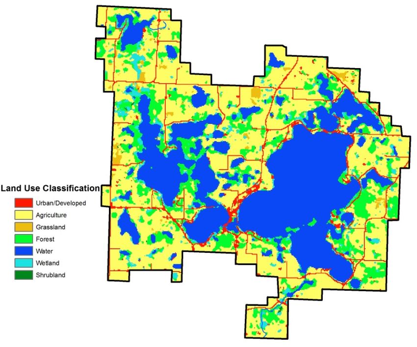
Chapter 1: Introduction

A.       INTRODUCTION TO THE CLWD

The Cormorant Lakes Watershed District (CLWD) was formed and approved by the State of Minnesota
Water Resources Board on August 22, 1966. The CLWD lies near the southwest corner of Becker
County and covers approximately 20,320 acres of land, small lakes and sloughs and approximately 7,922
acres of open water.

Office

The CLWD’s office is located at the Cormorant Community Center, 10929 County Highway 5, Pelican
Rapids, MN, 56572. Main email: admin@cormorantlakeswatershed.org.

Meetings

The CLWD conducts regular monthly meeting on the first Monday of each month starting at 7:00pm.
During the summer months mid-month inspection meetings are held usually on the 3rd Monday of each
month. If a meeting date falls on a legal holiday the meeting will be rescheduled. The time and date of
the rescheduled meeting will be posted on the Cormorant Community Center Posting Board at least 3
days prior to the meeting. Call the Administrator or any of the managers to confirm meeting times and
dates.

B.       ORIGINAL PURPOSE AND GOALS

The original watershed management plan of the Cormorant Lakes Watershed District, dated March 7,
1968, established a number of goals with the overall objective of resource conservation. These goals are
as follows.

1968 Original Goals

1) Control or alleviation of damage by floodwaters through the operation of a controlled outlet.

2) Improvement of stream channels for navigation, and any other public purpose.

3) Regulating the level and flow of streams and lakes and conserving the waters thereof.

4) Providing and conserving a high quality water supply for residential, recreational, agricultural, or
   other public uses.

5) Imposition of preventive or remedial measures for the control or alleviation of land and soil erosion
   and siltation of water courses or bodies of water affected thereby.

6) Regulating improvements by riparian landowners of the beds, banks, and shores of lakes, streams,
   and marshes by permit or otherwise in order to preserve the same for beneficial use.

CWLD Plan, 2012-2022                       Chapter 1: Introduction                                         1
7) Cooperate with Local, County, State, and Federal agencies concerning bridges, culverts, crossings,
   ditches and other matters that may affect transportation within the CLWD.

8) To monitor development of agricultural irrigation, and to respond to these developments in the best
   interests of the CLWD.

9) To monitor climatic events such as droughts, periods of excess rainfall and floods, and to react to
   these events in the best interest of the CLWD.

10) To monitor the developments in weather modification as it applies to the CLWD, and to respond to
    these developments in the best interest of the CLWD.

11) To acquire and maintain rainfall and lake level records for lakes within the CLWD.

12) To do any and all things necessary and proper to accomplish anyone or more of the general objectives
    for which the CLWD has been established.

1999 Goals

The plan was last updated in 1999, and included the following goals.

1) Insure an adequate supply of high-quality surface and groundwater for public and recreational use in
   drought cycles.

2) The control or alleviation of damage by floodwaters and continue efforts to develop a permanent
   operating plan for the outlet.

3) Maintain or improve water quality of all surface water and groundwater resources within the CLWD.

4) The CLWD will support all viable projects for reducing erosion that may impact water quality.

5) The CLWD will implement and monitor a program of erosion control and sedimentation management
   within all non-judicial ditch systems under its jurisdiction.

6) All subwatersheds of the CLWD will be inventoried and evaluated for erosion potential and control.

7) The CLWD will promote the enhancement of fish and wildlife habitat where it is determined to be in
   the best interest of the public and landowners of the CLWD.

8) Promote recreational opportunities wherever possible within projects of the CLWD.

9) All initiatives of the CLWD should utilize potential cooperative efforts with the appropriate Federal,
   State, County, Township, School Districts and local governments.

10) The CLWD shall seek to inform and educate residents, non-residents and visitors within its
    jurisdiction of all its ongoing activities and projects.

CWLD Plan, 2012-2022                       Chapter 1: Introduction                                          2
11) The CLWD shall continue to inform and educate the public "Within its jurisdiction of the benefits of
    the conservation of water and soil in the preservation and enhancement of our natural resources”.

Past Goals as related to today

The goals from 1968 and 1999 include many of the same issues facing the watershed today. Some of the
original goals have been met, such as operating a controlled outlet, improvement of stream channels via
new culverts, regulating riparian changes by landowners through permits, maintain lake level records, and
educating watershed residents. Other goals are still in progress such as inventorying and evaluating
subwatersheds, reducing erosion and maintaining and improving water quality. The watershed’s new
goals (Chapter 5) re-state the issues and priorities of the watershed for the next decade.

C.      WATERSHED RULES

The CLWD’s rules can be found in Appendix A. The watershed rules are updated as new issues arise.
One of the main changes in the CLWD that has had to be addressed is the rebuilding of existing cottages
into large homes, which changes the runoff on the property.

D.      CLWD EVOLUTION

The legal boundaries of the CLWD have remained unchanged since formation in 1966. However,
dramatic changes in the Becker County Zoning Ordinances that include Shore land Management Plans,
increased regulation by the State of Minnesota by and through the Minnesota Pollution Control Agency,
Environmental Quality Board, State Soil and Water Conservation Districts, Department of Natural
Resources, the Wetland Conservation Act and zoning authority exercised by local units of governments
such as Townships, the federal government acting through the United States Department of Agriculture
and the Army Corps of Engineers, have created an awareness that maintenance of the highest standards of
water quality is a shared concern. Protection of water quality requires cooperation and communication
with diverse units of government including local, state and federal agencies.

E.      DISTRICT’S MISSION
The primary mission of CLWD is to protect and enhance the quality of waters within its jurisdiction; to
ensure that appropriate decisions are made concerning the management of streams, wetlands, lakes,
groundwater, and related land resources which impact these waters; and to accomplish the purposes for
which a watershed district is established.

F.      MINNESOTA STATUTORY AUTHORITY

As part of the body of laws of the State of Minnesota that comprise the water policy of the State,
Minnesota Statute 103D.405, requires a watershed district to update the overall Water Management Plan
every 10 years to reflect upon and examine past efforts and to focus on the needs and challenges of the
future to allow the Managers to accept and perform their responsibilities entrusted by the public to protect
and preserve the environment for future generations.

CWLD Plan, 2012-2022                        Chapter 1: Introduction                                        3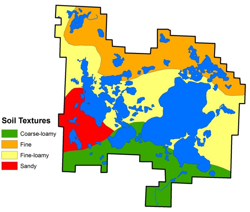
This page was intentionally left blank.

CWLD Plan, 2012-2022      Chapter 2: Description of the District   4
Chapter 2: Description of the CLWD

A.    WATERSHED SETTING

Location and Size

The CLWD is located in the Otter Tail River Major Watershed. The Otter Tail River Watershed
represents an area of about 1,920 square miles, including areas of substantial portions of Otter Tail,
Becker and Wilkin counties, and very small portions of Clay and Clearwater counties (Figure 1).

The watershed is a drainage basin of the Red River and the major tributaries of the watershed are the
Ottertail and Pelican Rivers. Where the Otter Tail River joins the Bois de Sioux River is considered to be
the headwaters of the Red River. The majority of the lakes in the Red River Basin are found in the Otter
Tail River watershed.

Figure 1. Watershed location of CLWD.

CWLD Plan, 2012-2022                    Chapter 2: Description of the District                           5
The CLWD lies near the southwest corner of Becker County. (Figure 1). It covers approximately 20,320
acres of land, small lakes and sloughs and approximately 7,922 acres of open water. Its boundaries are as
described in the Minnesota Water Resources Board's Order dated August 22, 1966, establishing the
CLWD as amended. Within the CLWD there are many small to medium sized farms, as well as many
small lots and home sites located around the various lakeshores. The public, through Federal, State,
County and Township governments, own a few small tracts, mainly as accesses to the lakes and wildlife
areas. The CLWD is accessible from all directions via gravel and blacktop roads and land transportation
within the CLWD is adequate by a network of County and Township roads. There are no railroads within
the CLWD.
Water Flowage
Water flowage in the CLWD starts at Bijou Lake near the northern border, and continues through Upper
Cormorant, Nelson Lake, Middle Cormorant and Big Cormorant. The natural ground water flowage out
of Big Cormorant is to the south via Pelican Lake and the Pelican River and the Ottertail River to the Red
River of the North. Surface water also flows to Pelican Lake through Spring Creek. Additional flowage
systems are; from Fig and Bergeson lakes into Rossman Lake, then into Upper Cormorant Lake; from
Dahlberg lake to Leif Lake then into Big Cormorant. Sub-watershed systems feed into all of the major
lakes from the surrounding territory.
Political Units within the CLWD
Becker County Board of Commissioners
Becker County Soil and Water Conservation
Lake Eunice Township
Cormorant Township
Audubon Township
Lake Park Township
Lake Park School District
Audubon School District
Pelican Rapids School District
Non-Profit Lake Associations
o Big Cormorant Lake Association
o Middle Cormorant Lake Association
o Upper Cormorant Lake Association
o Rossman, Nelson, Larson Lakes Association
o Bijou Lake Association
o Leif Lake Association
CWLD Plan, 2012-2022 Chapter 2: Description of the District 6Figure 2. Map of the Cormorant Lakes Watershed District. CWLD Plan, 2012-2022 Chapter 2: Description of the District 7
Population Characteristics

In the 1999 CLWD Watershed Plan, the CLWD population was estimated at 2,300. Census data are not
separately available for the Watershed District, but its population history can be represented by changes
which have taken place in the four townships that comprise most of the CLWD’s territory. In 2006, the
total population of the four townships was 3,366. Extrapolation data were obtained from the Minnesota
State Demography Office (Figure 3). The data show that population in Lake Eunice and Cormorant
Townships are expected to grow in the future, while Audubon and Lake Park Townships remain even.

Within the CLWD there are many small to medium sized farms, as well as many small lots and home
sites located around the various lakeshores. Most of the increase in population has occurred around
lakeshores in the CLWD.

                                  Population Estimatation for Townships in CLWD
                    2500

                    2000
       Population

                    1500                                                              Audubon township

                    1000                                                              Cormorant township
                                                                                      Lake Eunice township
                     500
                                                                                      Lake Park township
                       0
                           2006   2010   2015    2020      2025     2030      2035
                                                 Year

Figure 3. Population extrapolation estimates for townships in the CLWD from 2006-2035. Source:
http://www.demography.state.mn.us/resource.html?Id=19332

The Economy

The most significant land use within the Watershed District continues to be agriculture. Since the
formation of the CLWD in 1966, there has been a decline in the number of resorts. However, there has
been a significant increase in the number of year round residents on the lakes within the CLWD. The few
non-agricultural businesses within the CLWD are primarily service oriented to visitors of the lake area
and permanent residents. There is no manufacturing or heavy industry within the CLWD.

B.           PHYSICAL FEATURES

Climate

The climate of the area has warm summers and cold winters (Figure 4). Because of its location on the
continent, Minnesota is subject to large swings in both temperature and precipitation (Figures 4-5).

CWLD Plan, 2012-2022                       Chapter 2: Description of the District                            8
In the winter, the lakes in the CLWD freeze over. The ice-on season averages 153 days, although it is
highly variable from year to year. This winter freezing has a major effect on the lakes’ biology.
The Detroit Lakes area averages about 24 inches of precipitation annually. The majority of the
precipitation occurs in the summer months. Western Becker County has been in a trend of rising water
levels since the region entered a wet cycle in the early 1990s.
Monthly Temperature Range
Average High Average Low
100
80 76
80 79
69 69
Temperature (F)
60 58 57 56
55 53
44 47
40 37 36 35
31
24
20 16 17 20 21
3 4
0 ‐4
‐20
Figure 4. Monthly temperature range for Detroit Lakes, MN.
Average Precipitiation
5
4.41
4.5 4.03
4 3.67
Precipitation (inches)
3.5
2.97 3.02
3
2.5
2.5
2 1.54
1.5 1.15 1.1
1 0.76 0.64
0.57
0.5
0
Figure 5. Monthly precipitation range for Detroit Lakes, MN.
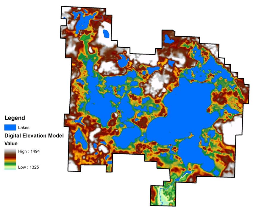
CWLD Plan, 2012-2022 Chapter 2: Description of the District 9Topography In terms of environmental quality, agriculture, and hydrology, understanding the topography of an area enables the understanding of watershed boundaries, drainage characteristics, water movement, and impacts on water quality. Elevations within the CLWD range from approximately 1,325 to 1,494 feet above sea level (Figure 6). Figure 6. Elevation of the Cormorant Lakes Watershed District. CWLD Plan, 2012-2022 Chapter 2: Description of the District 10
Geology

Geology in the CLWD can be
described as bedrock consisting of
slates, granites, minor intrusives and
greenstones in part overlain by
Cretaceous sediments that include
sandstones and shales (Figure 7).
These rocks are covered by 300 to
500 feet of glacial deposits
consisting of clay, loam till, sandy
till and sands and gravels. Some
shallow to deep peats and mucks are
found in the depression areas
throughout the watershed.

The Cormorant lakes were formed
by the last retreating glacier of the
Red River Lobe about 10,000 years

ago. As ice chunks broke off from          Figure 7. Geology of the Cormorant Lakes Watershed District left over
the retreating glacier, they melted in     from the retreating glaciers.
place to form kettle lakes.

Soils

Soil textures in the CLWD comprise
course-loamy, fine, fine-loamy and
sandy types (Figure 8). Soils can
affect many aspects of water
flowage in the CLWD. Sandy soils
are usually well-drained. Loamy
soil is composed of sand, silt and
clay and generally contains more
nutrients and humus than sandy
soils. Loams are gritty, moist and
retain water easily.

                                          Figure 8. Soil textures in the Cormorant Lakes Watershed District.

CWLD Plan, 2012-2022                     Chapter 2: Description of the District                                11
Land Use
Land Use in the CLWD is mainly agriculture (42.6%) and open water (32.4%) (Figure 9). Land use data
was derived from the Minnesota 2000 Level 1 Landsat Landcover Classification scheme developed by the
University of Minnesota’s Remote Sensing and Geospatial Analysis Laboratory and is depicted in Figure
9. The landcover type was derived via multitemporal, multispectral supervised image classification of
satellite imagery acquired by the Landsat TM and Landsat ETM+ satellites. The following is a
description of the seven level one landcover classes:
Urban/Developed - An area containing any amount of impervious cover of man-made
solid materials or compacted soils including areas with interspersed vegetation.
Examples: parking lots, shopping malls, warehouses, industrial parks, highways, sparse
development, single family residential developments, single lane roads, and mines.
Agriculture - An area where the primary cover type during the growing season is an
agricultural covertype including row crops, forage crops and small grains. Examples:
corn, soybeans, alfalfa, oats, wheat and barley.
Grassland - An upland area covered by cultivated or non-cultivated herbaceous
vegetation predominated by grasses, grass-like plants and forbs. Includes non-
agricultural upland vegetation dominated by short manicured grasses and forbs as well
as non-cultivated herbaceous upland vegetation dominated by native grasses and
forbs. Examples: golf courses, lawns, athletic fields, dry prairies and pastures.
Forest - An upland area of land covered with woody perennial plants, the tree reaching
a mature height of at least 6 feet tall with a definite crown. To be considered a forested
cover type the stand must have a combined species minimum of 3 cords/acre or 1,251
bd ft/acre or 251 stems/acre depending on size class (MNCSA Standards). Examples:
white pine, red pine, oak, mixed conifer and mixed deciduous.
Water - An area of open water with none or very little above surface vegetation.
Examples: lakes, streams, rivers and open wetlands.
Wetland - A lowland area with a cover of persistent and non-persistent herbaceous
plants standing above the surface of wet soil or water. Examples: cattails, marcs
grass, sedges and peat.
Shrubland - An upland or lowland area with vegetation that has a persistent woody
stem, generally with several basal shoots, low growth of less than 20 feet in height.
Area has less than 251 stems/acre of commercial tree species, the shrub species are
fairly uniformly distributed throughout and the density of the coverage is moderate to
high. Examples: alder, willow, buckthorn, hazel, sumac, and scrub oak.
CWLD Plan, 2012-2022 Chapter 2: Description of the District 12Figure 9. Land use classification in the Cormorant Lakes Watershed District.
Table 1. Land use area in the Cormorant Lakes Watershed District.
Land Use District Area (acres) Percent of District Area (%)
Urban/Developed 1,250 5.3
Agriculture 10,054 42.6
Grassland 284 1.2
Forest 3,321 14.1
Water 7,641 32.4
Wetland 1,026 4.3
Shrubland 20 0.1
Total 23,596 100
CWLD Plan, 2012-2022 Chapter 2: Description of the District 13Public & Private Land Ownership The majority of the land within the CLWD is privately owned, with approximately 539 acres of public land owned by the U.S. Fish and Wildlife Service and approximately 479 acres of public land owned by the Minnesota DNR (Figure 10). There are also about 450 acres under a U.S. Fish and Wildlife Service perpetual conservation easement that is not depicted in Figure 10. Figure 10. Land ownership in the Cormorant Lakes Watershed District. CWLD Plan, 2012-2022 Chapter 2: Description of the District 14
C. WATER RESOURCES
Major Sub-watersheds of the CLWD
The CLWD has two major subwatersheds: Spring
Creek (56006) and Middle Cormorant Lake (56080)
(Figure 11). Water flows from Middle Cormorant
Lake Watershed to Spring Creek Watershed and exits
the CLWD at the Big Cormorant Lake outlet control
structure.
Rivers and natural streams
There are no large rivers in the CLWD; however, a
stream flows out of Bijou Lake into Upper Cormorant
Lake. In addition, Spring Creek exits the south end of
Big Cormorant Lake and flows into Pelican Lake.
Lakes Figure 11. Major subwatersheds of the Cormorant Lakes
Watershed District.
The CLWD consists of the following lakes and their
established ordinary high water level (Table 2). Pursuant to Minnesota Statute 1030.005 subd. (14) the
ordinary high water level is defined as: 1) the boundary of water basins, watercourses, public waters, and
public waters wetlands; 2) an elevation delineating the highest water level that has been maintained for a
sufficient period of time to leave evidence upon the landscape, commonly the point where the natural
vegetation changes from predominately aquatic to predominately terrestrial.
Table 2. CLWD lakes and corresponding ordinary high water levels.
Lake Elevation (ft)
Bijou 1,369.5
Upper Cormorant 1,354
Nelson 1,354
Rossman (Erickson) 1,354.3
Middle Cormorant 1,354
Big Cormorant 1,354.6
Lief (Leaf) 1,354.6
Tub Not established
Pump Not established
Shoe Not established
Fig Not established
Bergeson 1,363.3
Peach Not established
Pete Not established
Larson Not established
Eilertson Not established
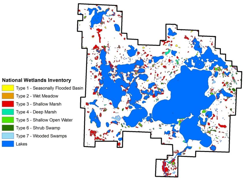
CWLD Plan, 2012-2022 Chapter 2: Description of the District 15Wetlands In addition to the above listed lakes, there are many sloughs, wetlands, water courses and basins that comprise subwatersheds that contribute to the major watersheds (Figure 12). These wetlands are important for water storage, water filtration and fish and wildlife habitat. Some of the wetlands in the CLWD have been ditched or partially drained (Figure 13). These areas could be targeted for restoration. Figure 12. Designated wetlands in the Cormorant Lakes Watershed District. Figure 13. Partially drained or ditched wetlands in the Cormorant Lakes Watershed District. CWLD Plan, 2012-2022 Chapter 2: Description of the District 16
Artificial drainage systems

There are no judicial ditches located within the
Watershed District. Private ditches may be present, and
need inventorying, which can be done in cooperation with
the Becker Soil and Water Conservation District.

Water management structures

There is an outlet control structure at the Spring Creek
outlet from Big Cormorant Lake (Figure 14). The
structure is controlled by the CLWD.

D.      EXISTING PROGRAMS AND POLICIES                             Figure 14. Big Cormorant Outlet water control structure
                                                                   location.
Local Government

Counties. The CLWD is located entirely within Becker County. Becker County has its own
Comprehensive Water Plan, completed in accordance with Chapter 103B of the Minnesota Statutes. The
Becker County Comprehensive Water Management Plans must be updated every five years in
accordance with current Minnesota legislative requirements. It is also a requirement that the
comprehensive water plans be consistent with watershed management plans covering the same
geographic area. Becker County regulates shore land zoning ordinances for the control of development
activity along the shorelines of lakes and streams, sub-surface sewage treatment systems, and the
established 100-year flood plains.

Townships. Each Township within the watershed district has the authority under Minnesota Law to
establish ordinances necessary for the administration of the Township. In some cases, these ordinances
relate to water management activities, especially drainage along or through township road systems.

Municipalities. There are no existing municipal governments in the CLWD which has been incorporated
under Minnesota Law, having the authority to establish ordinances and conduct zoning activities within
their territorial limits.

Soil and Water Conservation Districts. The Becker County. Soil and Water Conservation District
(SWCD) is established under Chapter 103C of the Minnesota Statutes. The purpose of the SWCD is to
promote programs and policies which can conserve the soil and water resources within their territorial
limits. They are particularly concerned with erosion of soil due to wind and water. Therefore, SWCDs
frequently are involved with the implementation of practices that effectively reduce or prevent erosion,
sedimentation, siltation, and agriculturally-related pollution in order to preserve water and soil as natural
resources. Watershed Districts in Minnesota may act as local sponsors for many types of water
management projects, including: grassed waterways, drainage ditches, erosion control structures, and
other water-related projects. The SWCDs receive a great deal of technical assistance from the United

CWLD Plan, 2012-2022                   Chapter 2: Description of the District                                   17
States Department of Agriculture Natural Resources Conservation Service (NRCS). Adjacent Watershed Districts. The CLWD is bounded to the north and west by the Buffalo Red River Watershed District and the Pelican River Watershed District to the northeast. To the east of the Watershed District is Becker County Judicial Ditch #20. Becker County is the drainage authority under Minnesota law for Judicial Ditch #20. The CLWD may be involved in joint activities with its neighboring watershed districts to coordinate water-related problems which affect both districts. State Government Minnesota Board of Water and Soil Resources. BWSR's duties include oversight programs and funding of State Soil and Water Conservation Districts, formation and guidance of Watershed Districts, the direction and assistance to counties in developing their Comprehensive Water Plans. A major activity of this Board is the development of policy toward the guidance of the development of legislative initiatives involving natural resources enhancement. The BWSR has no regulatory authority. However, it does review and approve water management plans and project activity of watershed districts and soil and water conservation districts. In addition, BWSR provides grant opportunities to LGUs to do water and land protection and restoration projects. Minnesota Department of Natural Resources. The Minnesota Department of Natural Resources (DNR) has both regulatory and an enforcement authority over natural resource programs of the state. The principal divisions of DNR include the Division of Ecological and Water Resources, the Division of Forestry, and the Division of Fish and Wildlife, the Division of Lands and Minerals, the Division of Enforcement and the Division of Parks and Trails. The DNR has permit authority over watershed district projects which impact the Protected Waters jurisdiction of the state. The DNR is also actively involved in helping local units of the government administer floodplain management ordinances and standards. The CLWD frequently cooperates with the DNR in the development and implementation of water management projects which enhance wetlands, wildlife habitat and improve water quality. Minnesota Pollution Control Agency. The Minnesota Pollution Control Agency (MPCA) has both regulatory and enforcement authority relative to potential actions which could affect the quality of the ground waters and surface waters of the state. Since many of the CLWD's projects involve water quality considerations, the Minnesota Pollution Control Agency becomes an active participant in these projects. The MPCA is the main agency assessing water quality and implementing Total Maximum Daily Load (TMDL) studies where needed. The MPCA also is involved with other governmental units, such as Becker County and Townships, in the construction and operation of private septic systems and feedlots that may impact water quality. Minnesota Environmental Quality Board. The Minnesota Environmental Quality Board (EQB) has final authority on permits involving a wide range of construction activity throughout the state. The Board is comprised of the commissioners of state agencies, the chairmen of state boards, and five citizens. The EQB bases its decisions on formal environmental assessments or environmental impact statements written for specific project proposals. CWLD Plan, 2012-2022 Chapter 2: Description of the District 18
Minnesota Department of Health. The Minnesota Department of Health (MDH) has permit authority and
regulatory authority for monitoring water supply facilities. These facilities include water wells, surface
water intakes, water treatment, and water distribution for public use.

Minnesota Department of Transportation. Several County and State Aid highway systems are
administered by the Minnesota Department of Transportation within watershed district boundaries.
CLWD projects requiring structures through MDOT regulated highways require coordination and
approval by the MDOT. In a similar fashion, MDOT activities relating to improvements of their highway
systems usually require a permit from the watershed district. The CLWD has executed a memorandum of
understanding with MDOT to provide early notification and input for projects planned within the
CLWD.

Federal Government

U.S. Army Corps of Engineers. The U.S. Army Corps of Engineers has permit and regulatory authority
over some projects of the CLWD. In addition the Corps of Engineers has been actively involved in
project development and construction in other watershed districts.

U.S. Department of Agriculture. Two major agencies of the U.S. Department of Agriculture have had a
great deal of impact on the activities of the CLWD. The Natural Resource Conservation Service (NRCS)
has traditionally provided technical advice and engineering design services to the local Soil and Water
Conservation District within the CLWD.

Under the Food Security Act of 1985, the USDA, through the ASCS and the SCS, administers rules
which, if violated, will result in the denial of agricultural subsidies and other governmental benefits. The
Managers believe the Conservation Reserve Program (CRP) has had a favorable impact on water quality.

U.S. Fish and Wildlife Service. The U.S. Fish and Wildlife Service (USFWS) has been actively involved
in the restoration of wetlands previously drained on agricultural land and now in the Conservation
Reserve Program of the U.S. Department of Agriculture. The USFWS has developed wetland projects
which beneficially affect the water management activities of the CLWD. In constructing these wetland
projects, the USFWS is required to obtain a permit from the CLWD before progressing, if the project is
located within the territorial jurisdiction of the CLWD.

Private Organizations

Ducks Unlimited (DU) is primarily involved in the design, construction, and funding of projects
enhancing duck habitat. The CLWD is interested in cooperating with Ducks Unlimited in the
development and funding of multipurpose projects for duck habitat and flood control.

Miscellaneous Wildlife, Conservation Lake Associations, and Sportsmen's Organizations. Within the
CLWD, there are numerous sportsmen's clubs and wildlife preservation groups. These organizations
sponsor a wide variety of environmentally positive initiatives, including wildlife habitat, wetland
development, and other activities which are beneficial to and consistent with the goals of the Cormorant

CWLD Plan, 2012-2022                  Chapter 2: Description of the District                              19
Lakes Watershed CLWD. The CLWD has an ongoing policy of cooperating with these groups in the
development of projects of mutual benefit.

CWLD Plan, 2012-2022              Chapter 2: Description of the District                       20
Chapter 3: Assessment of Resources

A.      WATER RESOURCES

A complete assessment of water quality in Big Cormorant, Upper Cormorant and Middle Cormorant
Lakes is scheduled to be completed by RMB Environmental Laboratories in the winter of 2011. The
results from these reports will be added as a future appendix to this plan, and will help guide the CLWD
in future projects.

Lake Water Quality

Trophic State Index (TSI)
is a standard measure or
means for calculating the
trophic status, or
productivity, of a lake.
More specifically, it is the
total weight of living
biological material
(biomass) in a waterbody
at a specific location and
time.

Phosphorus (nutrients),
chlorophyll a (algae
concentration) and Secchi
depth (transparency) are
related. As phosphorus
increases, there is more
food available for algae,
resulting in increased algal
concentrations. When
algal concentrations
increase, the water
becomes less transparent
and the Secchi depth
                               Figure 15. Trophic states of CLWD lakes.
decreases.

Trophic states are defined divisions of a continuum in water quality. The continuum is total phosphorus
concentration, chlorophyll a concentration and Secchi depth. Scientists define certain ranges in the above
lake measures as different trophic states so they can be easily referred to.

The CLWD lakes fall into the mesotrophic and eutrophic categories (Table 3, Figure 15). See the next
page for a description of each category.

CWLD Plan, 2012-2022                   Chapter 3: Assessment of Resources                              21
Table 3. Trophic state and trophic state index for lakes in the Cormorant Lakes Watershed District.
Mean TSI Mean TSI Mean TSI
Lake Mean TSI Trophic State Secchi phosphorus chlorophyll a
Big Cormorant 41 Mesotrophic 36 45 41
Middle Cormorant 46 Mesotrophic 43 47 47
Nelson 48 Mesotrophic 48 49 47
Upper Cormorant 50 Eutrophic 48 52 51
Leif 53 Eutrophic 51 53 54
Bijou 54 Eutrophic 51 56 55
Rossman 55 Eutrophic 53 58 54
Table 4. Explanation of the trophic state index and lake conditions. Modified from: Carlson, R.E. 1997. A trophic
state index for lakes. Limnology and Oceanography. 22:361-369.
TSI Attributes Fisheries & Recreation
80 Algal scums, few aquatic plants. Rough fish (carp) dominate; summer fish kills
possible.
CWLD Plan, 2012-2022 Chapter 3: Assessment of Resources 22Ecoregion Comparisons Minnesota is divided into 7 ecoregions based on land use, vegetation, precipitation and geology. The MPCA has developed a way to determine the "average range" of water quality expected for lakes in each ecoregion. The MPCA evaluated the lake water quality for reference lakes. These reference lakes are not considered pristine, but are considered to have little human impact and therefore are representative of the typical lakes within the ecoregion. The "average range" refers to the 25th - 75th percentile range for data within each ecoregion. Western Becker County is in the Central Hardwood Forest Ecoregion (Figure 16). This ecoregion is an area of transition between the forested areas to the north and east and the agricultural areas to the south and west. The Figure 16. Minnesota Ecoregions. terrain varies from rolling hills to smaller plains. Upland areas are forested by hardwoods and conifers. Plains include livestock pastures, hay fields and row crops such as potatoes, beans, peas and corn. The ecoregion contains many lakes, and water clarity and nutrient levels are moderate. Land surrounding many of these lakes has been developed for housing and recreation, and the densely populated metropolitan area dominates the eastern portion of this region. Water quality problems that face many of the water bodies in this area are associated with contaminated runoff from paved surfaces and lawns. All of the lakes in the CLWD are within the ecoregion averages (Table 5). Big Cormorant Lake is better than the expected average. See the table on the next page for details. CWLD Plan, 2012-2022 Chapter 3: Assessment of Resources 23
Table 5. CLWD lakes compared to the ecoregion average range.

                  North                                               Big
                  Central                           Big               Cormorant
Ecoregion:        Hardwood                          Cormorant         204                                    Upper                               Middle
                  Forest          Leif Lake         202 (Main)        (south bay)       Rossman              Cormorant         Nelson            Cormorant     Bijou
Total
Phosphorus
                  23 –50          32.6              20.3              15.3              45.5                 29.7              23.6              22.1          38.3
(ug/l)

Chlorophyll a
(ug/l)            5 – 22          12.1              3.6               3.7               14.6                 11.2              7.6               6.5           14.1

Secchi
Water Clarity
                  4.92 – 10.5     6                 17.4              15.1              5.3                  8.2               7.6               10.2          6.2
(ft)

                                                                                                                                                 Better than
                                                                                                                                                 ecoregion
                                  Within            Better than       Better than       Within               Within            Within                          Within
                                                                                                                                                 average for
                                  ecoregion         ecoregion         ecoregion         ecoregion            ecoregion         ecoregion                       ecoregion
                                                                                                                                                 phosphorus
Discussion                        average for all   average for all   average for all   average for all      average for all   average for all                 average for all
                                                                                                                                                 and within
                                  three             three             three             three                three             three                           three
                                                                                                                                                 average for
                                  parameters        parameters        parameter         parameters           parameters        parameters                      parameters
                                                                                                                                                 other
                                                                                                                                                 parameters

Ecoregion averages are the interquartile range (25th-75th) percentile for Ecoregion Reference Lakes, MPCA

http://www.pca.state.mn.us/index.php/topics/environmental-data/eda-environmental-data-access/eda-surface-water-searches/eda-guide-to-typical-minnesota-water-quality-
conditions.html

CWLD Plan, 2012-2022                                                    Chapter 3: Assessment of Resources                                                                       24
Impaired Waters The Clean Water Act requires states to publish a list every two years (even years) of the lakes not meeting certain water quality standards. This list is called the Impaired Waters List, and currently the 2010 version is in draft form. Data for each lake are assessed and tied to a designated use. For lakes, the most common types of impairment are mercury in fish tissue for the use of aquatic consumption (fish) and excess phosphorus for the use of aquatic recreation. Eutrophication The standard for excess phosphorus impairment in the western half of Becker County (North Central Hardwood Forest Ecoregion) is 45 ppb (ug/L) total phosphorus. To be considered impaired for phosphorus, a lake must have at least 10 data points of each phosphorus, chlorophyll-a and secchi disk in the past 10 years over these standards. Each lake is carefully considered by the MPCA and the data quality is checked. No lakes in the CLWD are considered impaired for phosphorus as of 2010. Mercury For excess mercury in fish tissue, the MPCA says "A water body will be considered impaired when the recommended fish consumption frequency is less than one meal per week for any member of the population." Mercury is a different type of pollutant in that most of it comes from outside Minnesota and is deposited here from the air. Approximately 30% of the mercury deposited by air in Minnesota originates from natural sources, such as volcanoes; 60% of mercury comes from human activities outside the state such as coal-fired power plants and mining. The remaining 10% originates in the state. Big Cormorant and Leif Lakes are considered impaired for mercury. They are part of the 2008 Mercury TMDL. TMDL stands for Total Maximum Daily Load. A TMDL defines how much of a pollutant can be in the water and still allow the lake to meet designated uses such as fish consumption and aquatic recreation. The long-term goal of the Mercury TMDL is for the fish to meet water quality standards; the approach for Minnesota’s share is mass reductions from state mercury sources. This Mercury TMDL establishes that there needs to be a 93% reduction in state emissions from 1990 for the state to meet its share. Water point sources will be required to stay below 1 percent of the total load to the state and all but the smallest dischargers will be required to develop mercury minimization plans. Air sources of mercury will have a 93% emission reduction goal from 1990 levels. Air sources will be divided into three sectors: products, energy, and mining. To read more about the Mercury TMDL, please visit the MCPA website: http://www.pca.state.mn.us/index.php/water/water-types-and- programs/minnesotas-impaired-waters-and-tmdls/tmdl-projects/special-projects/statewide-mercury-tmdl- pollutant-reduction-plan.html. It is important to note that just because a lake is not named on list that it is impaired for mercury, does not mean that it is safe to eat unlimited amounts of fish. It may just mean that it hasn't been tested yet. For fish consumption advice, please visit: http://www.health.state.mn.us/divs/eh/fish/index.html. MPCA Watershed Assessment Schedule CLWD is in the Otter Tail River Major Watershed (for more details, see page 5). This watershed is scheduled for assessment in 2016. In 2016, the MPCA will do a complete study of the surface water quality of the watershed and determine if any Total Maximum Daily Load (TMDL) projects are needed. Information from this assessment will be included in a future appendix to this plan. CWLD Plan, 2012-2022 Chapter 3: Assessment of Resources 25
Fisheries Assessments

Big Cormorant Status of the Fishery (as of 08/04/2008)

Big Cormorant is regarded as an excellent natural prairie walleye lake. At 3,421 acres, it is the second largest lake
in Becker County. Its relatively close proximity to the Fargo-Moorhead area results in heavy angling pressure and
shoreline development.

High water levels during the late 1990's resulted not only in changes to the shoreline and low-lying homes and
cabins, but also in changes to the fish community. The recently high water levels opened up additional northern
pike spawning habitat and the lake's pike population is still responding. The catch rate of pike reached its
historical high in 2008 at 9.5 pike per gill net. The lake's historic average is 3.5 pike per set. The high water
effects on the pike population is illustrated in the fact that in seven surveys prior to 2002, the average catch rate of
northern pike was just 1.8 per set. Increases in numbers of small pike often result in decreases in yellow perch, the
primary forage fish for walleye and northern pike in most lakes. This is what appears to be occurring in Big
Cormorant since yellow perch catches have remained substantially lower than normal since 2002.

Fortunately, the walleye population does not appear to have been adversely affected by the abnormally high
northern pike numbers. The 2008 walleye catch rate was higher than the lake's historical average at 30.1 walleyes
per experimental gill net. Sampled walleyes averaged approximately 14 inches in length and 1.2 pounds in weight
in 2008. Cormorant Lake is an excellent natural walleye lake with two strong year classes poised to enter the
current fishery. The 2005 and 2006 year classes both made up significant portions of the walleye sample in 2008.

In addition to the periodic, mid-summer test netting, the DNR began annual, fall electrofishing for young-of-the-
year walleyes in Big Cormorant in 2000. These studies indicated that year classes from the years 2000 and 2004
were weak and those from 2001, 2002, 2003, 2005, and 2007 were relatively strong. Age class frequencies from
mid-summer test netting in 2008 appear to show similar findings. This means that fall electrofishing data can
probably be used as a reliable indicator of year class strengths in Big Cormorant. While fish from the 2007 and
2008 year classes were too small to be completely vulnerable to sampling gear in summer, fall electrofishing
yielded catch rates of 38 and 32 young walleyes per hour, respectively. Fall electrofishing catch rates over 30
young-of-the-year walleyes per hour are considered relatively strong and this bodes well for near future walleye
angling in Big Cormorant.

Smallmouth bass are another target species present in good numbers. Smallmouth bass and bluegill catches were
higher in 2008 than those reported in any of the nine previous surveys since 1954. Black crappies and largemouth
bass can also be found in moderate numbers.

Big Cormorant Lake is scheduled to be surveyed again in 2011.

CWLD Plan, 2012-2022                        Chapter 3: Assessment of Resources                                       26
You can also read