Country Fiche Poland - VASAB
←
→
Page content transcription
If your browser does not render page correctly, please read the page content below
Country Fiche
   Poland

     Updated April 2021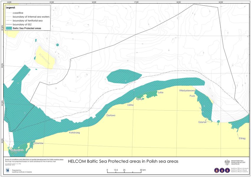
1. General information

   •   Internal sea waters: about 2 041 km2
   •   Territorial sea (12-nm zone): about 8 783 km2
   •   Marine contiguous zone (24-nm zone): about 7 787 km2
   •   Exclusive Economic Zone: about 19 736 km2

   1.1. Governance
Polish sea areas are governed by the Minister responsible for maritime economy affairs. The
sea area is administered by his regional maritime administration, i.e. the Director of
Maritime Office in Szczecin and Director of Maritime Office in Gdynia.

Directors of Maritime Offices are responsible for preparation of maritime spatial plans (see
section on plans). Construction, operation and use of artificial islands, installations or
structures, as well as laying of cables and pipelines, in Polish sea areas require obtaining a
permission. This permission is given, by means of an administrative decision. The organ
issuing the decision is either the Minister responsible for maritime economy or the
territorially competent Director of Maritime Office, depending on localization (EEZ,
territorial sea, internal sea waters) and status of spatial planning. Other types of permits and
licences for the use of the sea space (e.g. construction permits, mining licences, water law
permits) are issued by other public authorities, but always after obtaining agreement of the
appropriate organ of maritime administration (Minister responsible for maritime economy
or Director of Maritime Office).
                                               2
Contacts

MSP in general:              Ministry of Infrastructure
                             Mrs. Natalia Zając
                             Head of Maritime Spatial Planning Unit
                             ul. Nowy Świat 6/12, 00-400 Warszawa, Poland
                             Phone: +48 22 583 86 04
                             E-mail: natalia.zajac@mi.gov.pl

                             Maritime Office in Gdynia
                             Mrs. Małgorzata Gwara
                             Officer for Maritime Spatial Planning
                             ul. Chrzanowskiego 10, 81-338 Gdynia, Poland
                             Phone: +48 58 355 34 36
                             E-mail: malgorzata.gwara@umgdy.gov.pl

                             Maritime Office in Szczecin
                             Mrs. Marta Konik
                             Officer for Maritime Spatial Planning
                             pl. Batorego 4, 70-207 Szczecin, Poland
                             Phone: +48 91 440 32 68
                             E-mail: mkonik@ums.gov.pl

MSP Data Focal point:        Ministry of Infrastructure
                             Mr. Kamil Rybka
                             Chief expert
                             ul. Nowy Świat 6/12, 00-400 Warszawa, Poland
                             Phone: +48 22 583 85 68
                             E-mail: kamil.rybka@mgm.gov.pl

Espoo contact point:         General Directorate for Environmental Protection
                             Wawelska 52/54, 00-922 Warszawa, Poland
                             E-mail: kancelaria@gdos.gov.pl

Research:                    Maritime Institute of Maritime University in Gdynia
                             Mrs. Magda Matczak
                             Maritime Spatial Planning Unit
                             Długi Targ 41/42, 80-830 Gdańsk, Poland
                             Phone:+48 58 301 16 41
                             E-mail: magdalena.matczak@im.umg.edu.pl
2. General information on legislation
The first legal base for MSP was established in Poland in 2003.

2.1 The main legal act is “The Act on Sea Areas of Poland and Maritime Administration of
March 21st 1991” (Ustawa z dnia 21 marca 1991 r. o obszarach morskich Rzeczypospolitej

                                              3
Polskiej     i     administracji     morskiej)    available   in     Polish                at:
http://prawo.sejm.gov.pl/isap.nsf/download.xsp/WDU20190002169/O/D20192169.pdf

In order to implement Directive 2014/89/EU, the Polish Parliament has adopted changes on
The Act on Sea Areas of Poland and Maritime Administration of March 21st 1991, on 4th
September 2015, regarding inter alia, MSP procedure in Poland. Regulations concerning
maritime spatial planning are placed in Chapter 9: “Maritime spatial planning in maritime
internal waters, territorial sea and exclusive economic zone”. This chapter describes the
whole procedure, basis and principles of developing maritime spatial plans in Poland.

A maritime spatial plan is adopted by ordinance by the Council of Ministers. The drafts of the
plans are prepared by the territorially competent Directors of Maritime Offices.

Maritime spatial plans determine:
  • The destined use of the sea areas
  • Prohibitions and limitations in use of sea areas, taking into account the requirements
       of nature protection
  • Distribution of public investment
  • Directions for development of transport and technical infrastructure
  • Areas and conditions for protection of environment and cultural heritage

2.2 The supporting law is “Ministerial ordinance on required scope of MSPs in their textual
and graphic parts” (Rozporządzenie Ministra Gospodarki Morskiej i Żeglugi Śródlądowej oraz
Ministra Infrastruktury i Budownictwa z dnia 17 maja 2017 r. w sprawie wymaganego
zakresu planów zagospodarowania przestrzennego morskich wód wewnętrznych, morza
terytorialnego i wyłącznej strefy            ekonomicznej) available in Polish at
http://prawo.sejm.gov.pl/isap.nsf/DocDetails.xsp?id=WDU20170001025

The ordinance specifies:
   • MSP terminology,
   • scope of the plans and necessary links between different planning regimes (NATURA
       2000, terrestrial plans),
   • objects to be planned,
   • textual and graphics requirements.

2.3 An important role for MSP is also played by the “Act on access to information on
environment and its protection, public participation in environmental protection and on
environmental impact assessment” (ustawa z dnia 3 października 2008 r. o udostępnianiu
informacji o środowisku i jego ochronie, udziale społeczeństwa w ochronie środowiska oraz
o ocenach oddziaływania na środowisko). It stipulates that all spatial plans (in that maritime
plans) are subject to SEA procedure.

2.4 Several international conventions and binding legal acts such as UNCLOS, Espoo
Convention + Kiev Protocol, Bonn Convention (including EUROBAT, ASCOBANS), CBD, La
Valetta Convention, IMO Resolutions and conventions (E.G. MARPOL, COLREGS,
INTERVENTION), HELCOM recommendations, EU directives (MSFD, HABITAT, BIRD, SEA, EIA)
and many others are transposed to Polish national law.

                                              4
3. General applicability (e.g. territorial Sea, EEZ, other distinctions)
MSP regulations apply to the whole Polish sea area, i.e. the internal marine waters,
territorial sea and EEZ.
4. Spatial Plans
No maritime spatial plan has yet been officially adopted in Poland.
Designation categories:
• Priority use (Funkcja podstawowa),
• Allowed use (Funkcja dopuszczalna),
• Restricted use (Funkcja ograniczona),
• Forbidden use (Funkcja zakazana).
Planned Sea-uses:
• Transportation (T);
• Defence and National Security (B);
• Technical Infrastructure (I, Ip);
• Exploration, prospecting and extraction of minerals (K);
• Coastal protection (C);
• Environmental and nature conservation (O);
• Producing and storing renewable energy (E);
• Space reserved for future use (P, Pw);
• Multi-functional economic growth (M) - specific designation for Gulf of Gdańsk only;
• Environmentally conditioned local development (L) - specific designation for Puck bay
only;
• Artificial islands, installations and structures (W);
• Cultural heritage (D);
• Fishery (F);
• Aquaculture (A);
• Tourism, sport and recreation (S);
Information about where to access the MSP data:
MSP areas:
https://mapy.umgdy.gov.pl/pzp/apps/webappviewer/index.html?id=731dc0117f1f4c598e18
5b50a2842f68
Data regarding draft of the Maritime Spatial Plan of Polish Sea Areas in scale of 1:200 000
can be accessed via Maritime Office Gdynia website:
https://mapy.umgdy.gov.pl/pzp/
https://mapy.umgdy.gov.pl/pzp/home/group.html?id=bec4867931504e4897aa927629c5e03f#overvi
ew
OGC services:
https://mapy.umgdy.gov.pl/msp/
5What countries want to share
4.1. Pilot plans
Three pilot (non-binding) plans exist in Poland. They are used by the Polish Maritime
Administration in its daily decision making as a source of best available knowledge.
4.1.1. Pilot maritime spatial plan for the Western part of the Gulf of Gdańsk
The Pilot maritime spatial plan for the Western part of the Gulf of Gdańsk in its character is
a detailed plan with elements of a structural plan. It prioritizes certain uses and formulates
general requirements and detailed use restrictions. It covers 40,550 ha of sea area between
Gdynia and the Hel Peninsula. The graphic part is in scale of 1:25 000, under the “92” state
coordinate system. The plan covers following sea uses: water transport, water sports and
recreation, fishing, maritime structures including artificial islands and submerged structures,
technical linear infrastructure, nature conservation, cultural heritage, dredging, reeds,
ichthyofauna, sand extraction, dumping. It is based on a grid of sea subareas with defined
functions and detailed determinants. English version is available: J. Zaucha (ed.) (2009) Pilot
Draft Plan for the West Part of the Gulf of Gdansk. First Maritime Spatial Plan in Poland,
Gdańsk, 80 p., ISBN 978-83-62438-05-1, available at: http://www.im.gda.pl/wydawnictwa.
4.1.2. Pilot maritime spatial plan for Pomeranian Bight / Arkona Basin
Pilot maritime spatial plan for Pomeranian Bight / Arkona Basin is a strategic plan prioritizing
certain sea uses. It stipulates priority to certain uses and formulates general
recommendations, but it also excludes certain users from certain areas. It covers 14,100 km 2
of marine waters of Poland, Denmark, Germany and Sweden. The graphic part is in scale
1:2,000,000 in Mercator (54oN) projection (WGS84). The plan covers following sea uses:
water transport, water sports and recreation, fishing, maritime structures including artificial
islands and submerged structures, technical linear infrastructure, nature conservation,
cultural heritage, dredging, reeds, ichthyofauna, sand extraction, dumping.
English version is available: K. Gee, B. Käppeler, S. Toben, G. Chmura, S. Walkowicz, N.Nolte,
P.Schmidt, J. Lamp, C.Göke, C.Mohn, (2012) Developing a Pilot Maritime Spatial Plan for the
Pomeranian Bight and Arkona Basin, BaltSeaPlan Report 9 available at:
http://www.baltseaplan.eu/index.php/Pomeranian-Bight;832/1.
4.1.3. Pilot maritime spatial plan for the Southern Middle Bank
Pilot maritime spatial plan for the Southern Middle Bank is a strategic plan prioritizing
certain sea uses. It stipulates priority to certain uses and formulates general
recommendations, requirements and prohibitions, (limitations/prohibitions introduced only
in four cases). It covers 1751.5 km2 of EEZ of Poland and Sweden. The map of the plan is in
scale 1: 200 000, in azimuthally equal-surface Lambert projection (ETRS 1989 LAEA). The plan
covers following sea uses: water transport, fishing, mariculture, maritime structures
including artificial islands, technical linear infrastructure, nature conservation, ichthyofauna,
cultural heritage, sand extraction, research and defense. English version is available:
J.Zaucha, M.Matczak, (2012) Developing a Pilot Maritime Spatial Plan for the Southern
Middle Bank, BaltSeaPlan Report 10 available at:
http://www.baltseaplan.eu/index.php/Middle-Bank;833/1.
64.2. Good practices
Name of good Where Authors Source (where can be found)
practice tested
Know how on Gulf of Maritime J. Zaucha (ed.) (2009) Pilot Draft Plan for the West
maritime spatial Gdańsk Institute in Part of the Gulf of Gdansk. First Maritime Spatial
planning in Natura Gdansk Plan in Poland, Gdańsk
2000 areas http://www.im.gda.pl/wydawnictwa
Methodology for SEA Gulf of Maritime L. Kruk-Dowgiałło, R. Opioła & M. Michałek -
for maritime plans Gdańsk Institute in Pogorzelska (2011) Prognoza odziaływania na
Gdansk środowisko
Pilotażowego projektu planu zagospodarowania
przestrzennego zachodniej części Zatoki Gdańskiej.
BaltSeaPlan Report 18 available at:
http://www.baltseaplan.eu/index.php/Reports-and-
Publications;809/1#SEAGdasnsk
N. Nolte, M. Michałek L. J. Zaucha, J. Przedrzymirska,
Kruk-Dowgiałło & R. Opioła (2012) Strategic
Environmental Assessment in MSP.
Recommendations from the German and Polish
experience. BaltSeaPlan Report 25 available at
http://www.baltseaplan.eu/index.php/Reports-and-
Publications;809/1#SEA
Planning under high Southern Maritime J.Zaucha, M.Matczak, (2012) Developing a Pilot
level of uncertainty Middle Bank Institute in Maritime Spatial Plan for the Southern Middle Bank,
with regard to Gdansk BaltSeaPlan Report 10 available at:
ecological value of the http://www.baltseaplan.eu/index.php/Middle-
planned area Bank;833/1, p.69
(application of
precautionary
principle)
Identification and Southern Maritime J.Zaucha, (2012) Offshore Spatial Information -
classification of Middle Bank Institute in Maritime Spatial Planning in Poland “Regional
information gaps Gdansk Studies” vol. 46, No 4, 1 April 2012, pp. 459-473
Comprehensive list of Southern Maritime J.Zaucha, M.Matczak, (2012) Developing a Pilot
international Middle Institute in Maritime Spatial Plan for the Southern Middle Bank,
legislation relevant for Bank, Gdansk BaltSeaPlan Report 10 available at:
MSP in the EEZ. http://www.baltseaplan.eu/index.php/Middle-
Bank;833/1 pp.12,57-562
Stock taking on land Gulf of Maritime J. Zaucha (ed.) (2009) Pilot Draft Plan for the West
necessary for Gdańsk Institute in Part of the Gulf of Gdansk. First Maritime Spatial
elaboration of a Gdansk Plan in Poland, Gdańsk,
maritime spatial plan http://www.im.gda.pl/wydawnictwapp. 30-40
Delimitation of ‘sea Gulf of Maritime J. Zaucha (ed.) (2009) Pilot Draft Plan for the West
subareas (designated Gdańsk Institute in Part of the Gulf of Gdansk. First Maritime Spatial
areas) based on Gdansk Plan in Poland, Gdańsk,
functional http://www.im.gda.pl/wydawnictwa, pp. 47-48
characteristics in
particular ecological
features
Analysing national Southern Maritime J.Zaucha, M.Matczak, (2011) National and regional
policies affecting use Middle Bank Institute in strategies with relevance for
of sea space Gdansk Polish maritime space BaltSeaPlan Report 5 available
7at: http://www.baltseaplan.eu/index.php/Reports-
and-Publications;809/1#imapctassessment
5. New developments / current status
6.1 Maritime spatial planning process in Poland is divided into development of the following
plans:
• Maritime Spatial Plan of Polish Sea Areas in scale of 1:200 000
• Maritime Spatial Plans for Szczeciński Lagoon and Kamieński Lagoon
• Maritime Spatial Plans for Vistula Lagoon
• Maritime Spatial Plans for port area waters
• Detailed plans for selected areas covered by the Maritime Spatial Plan of Polish Sea
Areas in scale of 1:200 000
Maritime Spatial Plan of Polish Sea Areas in scale of 1:200 000
Preparation for this plan officially started on 15th November 2013. Plan will cover sea areas
referred to in the Act on Sea Areas of Poland and Maritime Administration of March 21st
1991 (with amendments), i.e.:
• exclusive economic zone and the contiguous zone,
• the territorial sea,
• internal waters adjacent to the territorial sea situated between the baseline of the
territorial sea and the coast line,
• internal waters of the Gulf of Gdansk with the exception of the waters of the ports
referred to in Article 4 Section 4 of the Act on Sea Areas of Poland and Maritime
Administration.
The first stage: “Study on the conditions of spatial development of Polish maritime areas
with spatial analysis” was completed on March 2015. The document is available in Polish at
maritime offices websites, for example: http://www.umgdy.gov.pl/?cat=96
English translation of text (without attachments) and chosen maps are available on the
website:
http://www.umgdy.gov.pl/wp-content/uploads/2015/04/INZ_Study_of_conditions.pdf
In late autumn 2015 Maritime Office in Gdynia signed grant agreement on elaboration of
the plan. In July 2015 the contractor of the draft plan has been chosen. On 2nd August 2016,
Director of the Maritime Office in Gdynia, acting also on behalf of the Director of Maritime
Office in Słupsk and Director of the Maritime Office in Szczecin, published official
information about starting of development of the “Maritime spatial plan for Polish maritime
areas on a scale of 1: 200 000” and strategic environmental assessment of the above plan. In
June 2018, the full first version of the plan was developed and submitted for official national
consultation process. The third national consultation meeting (the public discussion)
concerning the draft plan took place on 5 July 2018, in Szczecin. During the consultation
period, approximately 800 comments on the draft plan were submitted. At the beginning of
2019, the second version of the plan was developed and submitted for second round of
official national consultation process. Arrangements and opinions from competent
authorities have been collected in February 2019. They were often contradictory. The work
has been undertaken on them, which did result in development of the third version of the
8draft plan. The fourth and final national consultation meeting was held in Warsaw on 6 June
2019.
In terms of international cooperation and consultations, there were organized meetings with
representatives from Baltic Sea Region countries. First international informational and
discussion meeting concerning development of the “Maritime spatial plan for Polish sea
areas in scale 1:200 000” took place in Gdansk on 18-19 October 2016. Invited were
representatives of national authorities responsible for planning and management of sea
areas. Second international cooperation and consultations meeting, where first preliminary
draft of the Polish plan was presented, took place in Warsaw on 6-7 November 2017. The
third and the last international consultations meeting took place on 4-5 June 2019 in
Warsaw. During this meeting the third draft of the plan was presented, and countries had
the opportunity to submit substantive comments on the documentation. The official
procedure of transboundary environmental impact assessment of the draft plan, led by the
General Directorate for Environmental Protection, started in February 2020. In April 2021
the Council of Ministers adopted the plan. After publishing in the Official Journal, it will
become binding.
English and Germany translation of the draft plan and Environmental Report (chosen
paragraphs) is available on the website:
https://polishmsp.eu/
Maritime Spatial Plans for Szczeciński Lagoon and Kamieński Lagoon
Director of Maritime Office in Szczecin has officially started to prepare draft plans for
Szczeciński Lagoon and for Kamieński Lagoon in January 2017. Data inventory, study of
spatial conditions and assumptions for the draft plans were prepared in the period January
2017 - March 2018. The concepts of the draft plans were elaborated in the period April -
November 2018. At the end of 2018, the draft plans for lagoons were developed and
submitted for official national consultation process. Each stage of work was accompanied by
activities related to public participation and strategic environmental assessment. The public
discussion took place in mid-January 2019. After collecting comments from competent
authorities and stakeholders the second version of the draft plans were prepared and had to
be the subjected to the second round of agreements and opinions. The draft plan for the
Szczeciński Lagoon was presented to the German side in May 2019. Currently,
documentation is being prepared to take further steps resulting from the planning
procedure. The progress of work and consulted documentation are available in Polish at:
http://www.ums.gov.pl/9-informacje/147-projekty-planow-zagospodarowania-
przestrzennego-polskich-obszarow-morskich-morskich-wod-wewnetrznych-dla-zalewu-
szczecinskiego-i-zalewu-kamienskiego-projekt-powr-02-19-00-00-pm01-16.html.
Maritime Spatial Plans for Vistula Lagoon – a plan is being developed.
Maritime Spatial Plans for port area waters, i.e. Szczecin, Świnoujście, Police, Dziwnów,
Trzebież, Łeba, Ustka, Rowy, Kołobrzeg, Darłowo and Dźwirzyno are in the final stage of
elaboration process, while Gdańsk, Gdynia, Hel, Władysławowo, Elbląg and Mrzeżyno are
still under development.
9Detailed plans for selected areas covered by the Maritime Spatial Plan of Polish Sea Areas
in scale of 1:200 000 - work on these plans will be the last stage of planning process in Polish
maritime areas and will start after the adoption of the Maritime Spatial Plan of Polish Sea
Areas in scale of 1:200 000. Detailed plans will be prepared in a larger scale and will be
consistent with the solutions of the Maritime Spatial Plan of Polish Sea Areas in scale of
1:200 000 and will constitute its necessary specification. The detailed maritime spatial plan
for Gdańsk Bay is under preparation.
6. How coastal and marine Baltic Sea protected areas (HELCOM MPAs) are
taken into account in MSP
Poland, while elaborating its MSP, will follow the HELCOM-VASAB guiding principle of spatial
development of the sea areas (2012), where one of them is the so called ecosystem
approach - demanding inter-sectoral and sustainable management of human activities and
whose aim is to achieve a good ecological status of the Baltic Sea environment. The
ecosystem approach is also underlined in Polish Act on Sea Areas of Poland and Maritime
Administration of March 21st 1991 (JoL 2019, pos. 2169 as amended).
Draft plan preparation will be accompanied by the Strategic Environmental Assessment
procedure.
Coastal and marine protected areas are taken into consideration in Polish MSP on the basis
of the Act on Sea Areas of Poland and Maritime Administration and Ministerial ordinance on
required scope of MSPs in their textual and graphic parts - accordingly the plan should
decide on prohibitions and injunctions in the use of MPA; should include the already
approved arrangements of the conservation plans of national and landscape parks, nature
reserves, Natura 2000 and other forms of protection.
Highly important for the preparation of maritime spatial plans is the Act of 16 April 2004 on
Nature Conservation (consolidated text JoL 2020, pos. 55 ), which states that conservation
objectives are implemented, among others, by taking into account the requirements of
nature conservation in spatial planning of internal sea waters, territorial sea and exclusive
economic zone. Parts of a maritime spatial plan which concern a nature reserve and its
buffer zone, a landscape park and its buffer, and area of protected landscape require
coordination with the Regional Director of Environmental Protection in scope of the
solutions of the plan which could have a negative impact on the protected area.
In practise the information on the MPA are included in the planning process from the very
beginning – starting from the data and knowledge inventory. The Polish MSP Inventory
(2015) has shown that Polish sea areas are characterized by diverse natural values, which is
reflected in the quality, quantity and size of protected areas established in them.
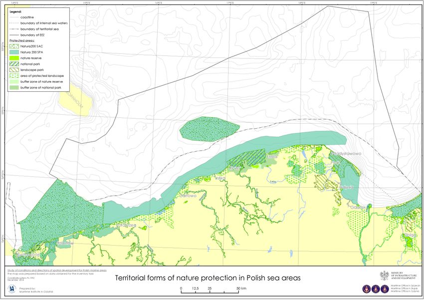
These protected areas include the highest spatial forms of nature protection:
• two national parks - Woliński and Słowiński;
• five Natura 2000 Special Areas of Conservation (SAC) - Puck Bay and Hel
Peninsula, Cliffs and Stone Reefs of Orłowo/ Gdynia, Vistula river mouth
refuge Slowinska Refuge, Refuge in Pomeranian Bay,
10• four NATURA 2000 Special Protection Areas (SPA) - Puck Bay, Vistula River
Delta, Pomeranian Bay, Baltic Coastal Waters,
• Słupsk Bank as an area of special protection of habitats Natura 2000 network
and Areas of Special Birds Protection Natura 2000.
In Poland, no new protected areas were established under the Helsinki Convention. Instead,
nine of Natura 2000 areas (all with largest area) were given the status of HELCOM Baltic Sea
Protected Area. The total surface of the protected areas is 6494 km2, which represents
almost 20% of all Polish sea areas.
1112
You can also read